List of rocks on Mars
This is an alphabetical list of named rocks (and meteorites) found on Mars, by mission. This list does not include Martian meteorites found on Earth.
Names for Mars rocks are largely unofficial designations used for ease of discussion purposes, as the International Astronomical Union's official Martian naming system declares that objects smaller than 100 m (330 ft) are not to be given official names. Because of this, some less significant rocks seen in photos returned by Mars rovers have been named more than once, and others have even had their names changed later due to conflicts or even matters of opinion. Often rocks are named after the children or family members of astronauts or NASA employees. The name "Jazzy", for example, was taken from a girl named "Jazzy" who grew up in Grand Junction, CO, USA. Her father worked for NASA and contributed to the findings and naming of the rocks.
 |
 |
 |
 |
 |
 |
 |
 |
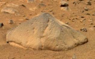
| Adirondack (Spirit) |
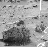
Barnacle Bill (Sojourner) |
Bathurst Inlet (Curiosity) |
Big Joe* (Viking) |
Block Island (Opportunity) M |
Bounce (Opportunity) |
Coronation (Curiosity) |
El Capitan (Opportunity) |
 |
 |
 |
 |
 |
 |
 |
.jpg) |
| Esperance* (Opportunity) |
Goulburn (Curiosity) |
Heat Shield (Opportunity) M |
Home Plate (Spirit) |
Hottah (Curiosity) |
Jake Matijevic (Curiosity) |
Last Chance (Opportunity) |
Link (Curiosity) |
 |
 |
.jpg) |
 |
 |
 |
 |
 |
| Mackinac Island (Opportunity) M |
Mimi* (Spirit) |
Oileán Ruaidh (Opportunity) M |
Pot of Gold (Spirit) |
Rocknest 3 (Curiosity) |
Shelter Island (Opportunity) M |
Tintina (Curiosity) |
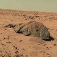
Yogi (Sojourner) |
| Notes: * = linked article is about the mission that encountered this rock; M = Meteorite - () | |||||||
1976 – Viking program: Viking 1 and Viking 2 landers
Viking 1 Lander – July 20, 1976; Last Earth Contact – November 13, 1982.[1][2]
Mars landing coordinates: 22°29′N 49°58′W / 22.48°N 49.97°W[1]
Viking 2 Lander – September 3, 1976; Last Earth Contact – April 11, 1980.[1][3]
Mars landing coordinates: 47°58′N 225°44′W / 47.97°N 225.74°W[1]
(Raw Images - Camera/Sol and 1-JPL and 2-JPL + NASA Image Viewer.)
- Big Joe
- Bonneville
- Delta
- Midas Muffler
- Mr. Badger
- Mr. Moley
- Mr. Rat
- Mr. Toad
- Patch
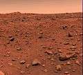 Rocks on Mars – viewed by the Viking 1 Lander (July 21, 1976).
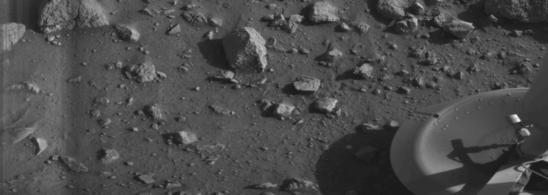
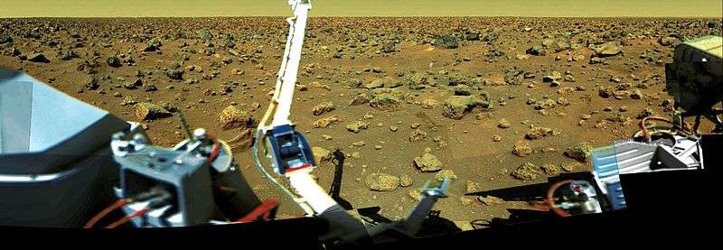
 Rocks on Mars – viewed by the Viking 2 Lander (September 5, 1976).
 Rocks on Mars – viewed by the Viking 2 Lander (September 25, 1977).

1997 – Sojourner rover (Mars Pathfinder)
Sojourner Rover – July 4, 1997; Last Earth Contact – September 27, 1997.[4]
Mars landing coordinates: 19°7′48″N 33°13′12″W / 19.13000°N 33.22000°W
(Raw Images - 1-Camera/Sol and 2-Camera/Sol and 3-Camera/Sol and 1-JPL and 2-JPL + NASA Image Viewer.)
- Anthill
- Auto
- Baby Otter
- Bama
- Bambam
- Barnacle Bill
- Barsoom
- Basket
- Bebob
- Blackhawk
- Book Shelf
- Booboo
- Bosco
- Boyle
- Brak
- Brick
- Broken Wall
- Bug
- Bullwinkle
- Bunky
- Cabbage Patch
- Calvin
- Cardiac Hill
- Casper
- Chimp
- Clumk
- Contour
- Couch
- Cradle
- Darth Vader
- Desert Princess
- Dilbert
- Dilbert's Boss
- Dogbert
- Dragon
- Duck
- Elvis
- Ender
- Flat Top
- Flipper
- Flute Top
- Frog
- Froggy
- Garfield
- Garibaldi
- Garrak
- Geordi
- Ginger
- Goldilocks
- Goose
- Gosling
- Grandma
- Grizzly
- Grommit
- Gumby
- Half Dome
- Hamster
- Hardstop
- Hassock
- Hedgehog
- Hero
- Hippo
- Hobbs
- Homer
- Hoppy
- Iggie
- Iguana
- Indiana Jones
- Jailhouse
- Janeway
- Jazzy
- Jedi
- Jimmy Cricket
- Kitten
- Lamb
- Landon
- Little Flat Top
- Longhorn
- Lookout
- Lozenge
- Lumpy
- Lunchbox
- Mafalda
- Marvin the Martian
- Matterhorn
- Mesa
- Mini
- Mint Julep
- Moe
- Mohawk
- Mouse
- Mr. Mole
- Nibbles
- Nigel
- Obelisk
- Otter
- Pancake
- Paz
- Penguin
- Picnic
- Piglet
- Pinky
- Pinocchio
- Piper
- Platypus
- Pokey
- Poohbear
- Poptart
- Potato
- Pumpkin
- Pyramid
- Pyramid Point
- Ratbert
- Ren
- Rocky
- Rolling Stone
- Rye Bread
- Sandworm
- Sardine
- Sassafras
- Scooby Doo
- Scout
- Seawolf
- Shaggy
- Shark
- Simba
- Sisyphus
- Smidgen
- Snoopy
- Snowy
- Snukums
- Souffle
- Squash
- Squeeze
- Space Ghost
- Spock
- Spud
- Stack
- Stimpy
- Stripe
- Stump
- Sulu
- T. Rex
- The Dice
- Tick
- Tigger
- Titus
- Torres
- Troll
- Trooper
- Turtle
- Tweak
- Valentine
- Warthog
- Wedge
- Woodie
- Yogi
- Zaphod
- Zorak
- Zucchini
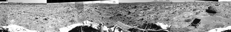
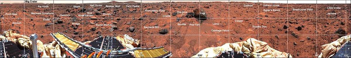
 Rover Map of Sojourner's route on Mars (Sol 83, 1997) (Archive).
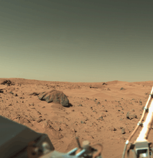
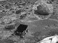
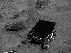 "Barnacle Bill" rock on Mars – near the Sojourner Rover.
- "Barnacle Bill" rock on Mars - viewed by the Sojourner Rover.
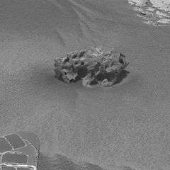
 "Yogi" rock (circled) on Mars – near the Sojourner Rover.
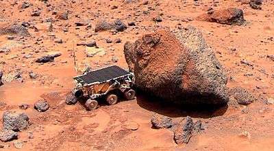 "Yogi" rock on Mars – analyzed by the Sojourner Rover.
- "Yogi" rock on Mars - viewed by the Sojourner Rover.
2004 – Spirit rover (MER-A)
Spirit Rover – January 4, 2004; Last Earth Contact – May 25, 2011.[5]
Mars landing coordinates: 14°34′06″S 175°28′21″E / 14.5684°S 175.472636°E[6]
(Raw Images - Camera/Sol and JPL + NASA Image Viewer.)
- Aboa
- Adirondack
- Allan Hills (iron meteorite)
- Arctowski
- Belgrand
- Bread-Basket
- Casey Station
- Castilla
- ChanCheng
- Cheyenne
- Clovis
- Coba
- Cobra Hoods
- Concordia
- Davis
- Druzhnaya
- Ebenezer
- El Dorado
- Esperanza
- Faget (geological feature)
- Ferraz
- Garruchaga
- Gueslega
- Halley
- Home Plate (geological feature)
- Humphrey
- Juan Carlos
- Jubany
- King George Island
- Kohnen
- Korolev
- Macquarie
- Magic Carpet
- Marambio
- Mazatzal
- Melchior
- Mimi
- Molodezhnaya
- Montalva
- Oberth (geological feature)
- O Higgens
- Orcadas
- Pot of Gold
- Prat
- Primero
- Riquelme
- San Martin
- Sashimi
- Scott Base
- Sejong
- Signy
- Sobral
- Stone Council
- Sushi
- Tetl
- Tor
- Tyrone
- Vernadsky
- Vostok
- Wasa
- White Boat
- Wishstone
- Zhong Shan (iron meteorite)
 Rover Map of Spirit's route on Mars (Sol 1509, April 2, 2008) (Archive to Sol 2555, March 15, 2011 Current).
- "Adirondack" rock on Mars – viewed by the Spirit Rover.
- "Home Plate" rock outcrop on Mars – studied by the Spirit Rover.
- "Mimi" rock on Mars – viewed by the Spirit Rover.
- "Pot of Gold" rock on Mars – viewed by the Spirit Rover.

2004 – Opportunity rover (MER-B)
Opportunity Rover – January 25, 2004; CURRENTLY ACTIVE.[7]
Mars landing coordinates: 1°56′46″S 354°28′24″E / 1.9462°S 354.4734°E[6]
(Raw Images - Camera/Sol and JPL + NASA Image Viewer.)
- Amboy
- Berry Bowl
- Baltra
- Block Island (iron meteorite)
- "Blueberries"
- Bounce
- Bylot
- Carousel
- Chapeco
- Cheyenne
- Chocolate Hills
- Cookies N Cream
- Diamond Jenness
- Earhart
- El Capitan
- Edmund
- Ellesmere
- Escher
- Esperance[8]
- Flatrock
- Florianopolis
- Guadalupe
- Heat Shield (iron meteorite)
- Homestake (vein)
- Igreja
- Ice Cream
- Joacaba
- Joseph McCoy
- Kalavrita
- Kettlestone
- Kirkwood
- Lamination
- Last Chance
- Lion Stone
- Mackinac Island (iron meteorite)
- Marquette Island
- McKittrick
- Meridiani Planum (iron meteorite)
- Oileán Ruaidh (iron meteorite)
- Palemop
- Pilbara
- Pinnacle Island
- Puffin
- Pyrrho
- Razorback
- Santa Catarina
- Sarah
- Sergeant Charles Floyd
- Shark Pellets
- Shark's Tooth
- Shelter Island (iron meteorite)
- Shoemaker
- Slick
- Snout
- "Sparkling Spheres"
- SpongeBob SquarePants
- Steffers
- Stone Mountain
- Tennessee
- The Outcrop
- Tipuna
- Tubarao
- Videira
- Wave Ripple
- Whitewater River
- Wopmay
- Xanxer
- Yuri
 Rover Map of Opportunity's route on Mars (Sol 2055, January 24, 2009) (Archive to Sol 3342, June 21, 2013 Current).
- "Block Island" meteorite on Mars – viewed by the Opportunity Rover (July 31, 2009).
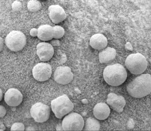 "Blueberries" (hematite spheres) on rock outcrop at Eagle Crater – viewed by the Opportunity Rover (Sol 46 – March, 2004).
 "Blueberries" at "Kirkwood" near Endeavour Crater – Opportunity Rover (September 6, 2012).
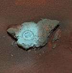
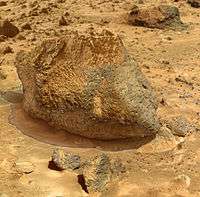
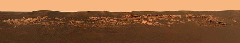
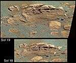 "El Capitan" rock outcrop on Mars – studied by the Opportunity Rover.
- "El Capitan" rock outcrop on Mars – studied by the Opportunity Rover.
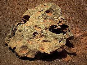
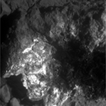
- "Heat Shield" meteorite (officially, Meridiani Planum meteorite) on Mars – viewed by the Opportunity Rover (January 6, 2005).
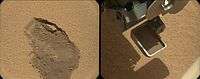
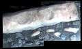 "Homestake" vein on Mars – viewed by the Opportunity Rover (November 12, 2012).
- "Last Chance" rock outcrop on Mars – viewed by the Opportunity Rover.
- "Mackinac Island" meteorite on Mars – viewed by the Opportunity Rover (October 13, 2009).
- "Oileán Ruaidh" meteorite on Mars – viewed by the Opportunity Rover (September 24, 2010).

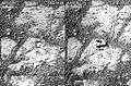
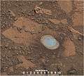
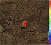
 "Pinnacle Island" rock - location where rock was dislodged by Opportunity (February 4, 2014).
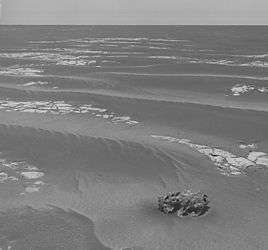 "Shelter Island" meteorite on Mars – viewed by the Opportunity Rover (October 3, 2009).
- "Shelter Island" meteorite on Mars – viewed by the Opportunity Rover (October 1, 2009).
 "Sparkling Spheres" embedded in trench wall at Meridiani Planum - viewed by the Opportunity Rover (February, 2004).
 "Whitewater River" rock on Mars – viewed by the Opportunity Rover (November 12, 2012).

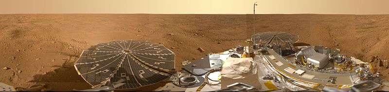
2008 – Phoenix lander
Phoenix Lander – May 25, 2008; Last Earth Contact – November 10, 2008.[11]
Mars landing coordinates: 68°13′N 125°42′W / 68.22°N 125.7°W
(Raw Images - Camera/Sol and JPL + NASA Image Viewer.)
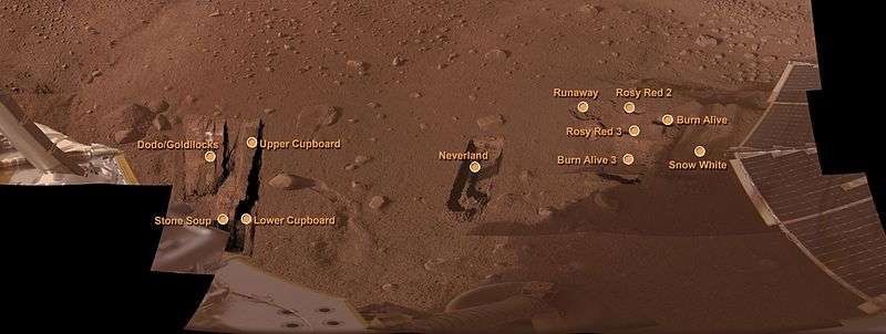
- Baby Bear
- Burn Alive
- Burn Alive 3
- Dodo
- Goldilocks
- Lower Cupboard
- Mama Bear
- Neverland
- Papa Bear
- Rosy Red 2
- Rosy Red 3
- Runaway
- Snow White
- Stone Soup
- Upper Cupboard
2012 – Curiosity rover (Mars Science Laboratory)
Curiosity Rover – August 6, 2012; CURRENTLY ACTIVE.[12]
Mars landing coordinates: 4°35′22″S 137°26′30″E / 4.5895°S 137.4417°E (4°35′31″S 137°26′25″E / 4.59194°S 137.44028°E)
(Raw Images - Camera and Sol and 1-JPL and 2-JPL + NASA Image Viewer.)
- Alexander Hills (area)
- Amargosa Valley (area)
- Bathurst Inlet
- Bonanza King
- Book Cliffs (area)
- Buckskin
- Burwash
- Chinle (area)
- Confidence Hills (area)
- Coronation
- Crest
- Crestaurum
- Cumberland
- Darwin Outcrop
- Dingo Gap (area)
- Discovery Ridge (area)
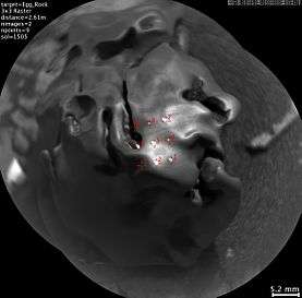
- Egg Rock (meteorite)
- Ekwir_1
- Et-Then
- Garden City (area)
- Gillespie (area)
- Gillespie Lake
- Glenelg (area)
- Goulburn
- Harrison
- Hidden Valley (area)
- High Dune (area)
- Hottah
- Ithaca
- Jake Matijevic
- John Klein-A/B/C
- Kimberley (area)
- Knorr[13]
- Lamoose
- Lebanon (iron meteorite)
- Link
- Missoula
- Mojave (area)
- Mojave 2
- Murray Unit (area)
- Namib Dune (area)
- Not Bones
- Nova
- Pahrump Hills (area)
- Panorama Point (area)
- Pink Cliffs (area)
- Point Lake (area)
- Portage[14]
- Rapitan
- Rocknest (area)
- Rocknest 3[15]
- Sayunei
- Selwyn
- Shaler[16][17]
- Sheepbed
- Shoemaker
- Snake River[18]
- Stimson unit (area)
- Sutton Inlier (area)[13]
- Telegraph Peak (area)
- Tintina[13][19]
- Twin Cairns Island (area)
- Unnamed-20120902
- Waypoint 1 (area)
- Wernecke[13]
- Whale
- Wildrose
- Windjana
- Winnipesaukee
- Yellowjacket
- Yellowknife Bay (area)
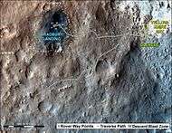 First-Year & First-Mile Traverse Map of the Curiosity rover on Mars (August 1, 2013; 3-D).
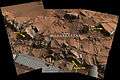 "Alexander Hills" bedrock on Mars - viewed by Curiosity (November 23, 2014).
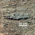
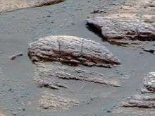
- "Bathurst Inlet" rock on Mars – as viewed by the MAHLI camera on the Curiosity rover (September 30, 2012).
 "Bonanza King" rock on Mars - dusted and initially drilled (September 11, 2014).
 "Bonanza King" rock on Mars - drilling stopped due to loose rock (September 11, 2014).
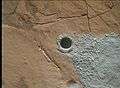 "Buckskin" rock on Mars – Curiosity drilling site
(July 30, 2015). "Burwash" rock on Mars – as viewed by the MAHLI camera on the Curiosity rover (October 29, 2012).
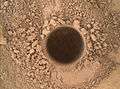 "Confidence Hills" rock on Mars - Curiosity's first target at Mount Sharp (September 24, 2014).
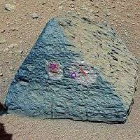
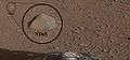 "Coronation" rock on Mars – first target of the ChemCam laser analyzer on the Curiosity rover (August 17, 2012).
- "Coronation" rock on Mars – close-up - viewed by the Curiosity rover (August 17, 2012).
 "Crestaurum" sand patch on Mars – before/after ChemCam laser hits – as viewed by Curiosity (October 20, 2012).
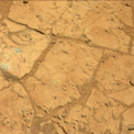
 "Cumberland" bedrock on Mars - Curiosity's second drilling site (Yellowknife Bay; February 19, 2013; white balanced).
 "Darwin" rock outcrop on Mars - viewed by Curiosity (Waypoint 1; September 10, 2013; overview).
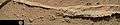 "Darwin" rock outcrop ridge - viewed by Curiosity (Waypoint1; September 21, 2013; context).
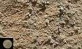 "Darwin" sandstone on Mars - viewed by the Curiosity rover (Waypoint 1; September 21, 2013; closeup).
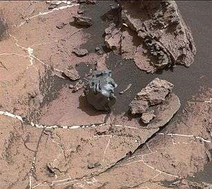
 "Ekwir_1" rock on Mars – cleaned with Curiosity's "Dust Removal Tool" (DRT) (January 6, 2013; closeup).
 "Et-Then" rock on Mars – as viewed by the MAHLI camera on the Curiosity rover (October 29, 2012).
 "Garden City" rock – as viewed by the Curiosity rover (March 18, 2015).
 "Garden City" rock - closeup – as viewed by the MAHLI camera on the Curiosity rover (March 2, 2015).
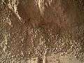
 "Gillespie Lake" rock texture – as viewed by the MAHLI camera on the Curiosity rover (December 19, 2012).
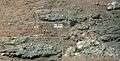
- "Goulburn" rock outcrop on Mars – close-up viewed by Curiosity (August 17, 2012).
 "Harrison" rock (and crystals) on Mars – viewed by the Curiosity rover (January 15, 2014).
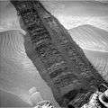 "Hidden Valley" sand - Curiosity's tracks (August 4, 2014).
 "Hidden Valley" water-related sedimentary deposits on Mars – Curiosity rover (August 7, 2014).
 "High Dune" sand (undisturbed) on Mars – Curiosity rover (December 5, 2015).
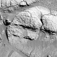
- "Hottah" rock outcrop on Mars – ancient streambed viewed by Curiosity (September 12, 2012; closeup; 3-D).
 "Ithaca" rock on Mars – target of the ChemCam laser analyzer on Curiosity (October 30, 2013; closeup).
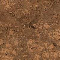
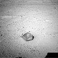 "Jake Matijevic" rock on Mars – a prime test target of the Curiosity rover (September 19, 2012).
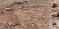
 "John Klein" mudstone - drill hole (1.6 cm (0.63 in)) made by Curiosity (Yellowknife Bay; May 10, 2013).
 "Lamoose" rock (high silica levels) – viewed by Curiosity (July 11, 2015).
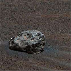
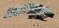 "Lebanon" meteorite on Mars – viewed by Curiosity (May 25, 2014).
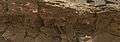 "Missoula" rock outcrop on Mars – viewed by Curiosity (July 1, 2015).
 "Missoula" rock outcrop – "Buckskin" drilling site (July 1, 2015).
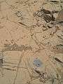 "Mojave 2" rock on Mars – drilling site - viewed by Curiosity (December 31, 2015).
 "Murray Unit" sandstone nodules – viewed by Curiosity (March 9, 2016).
 "Namib Dune" sand on Mars (at night) – (Curiosity rover; January 22, 2016).
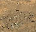 "Not Bones" on Mars - viewed by Curiosity (August 21, 2014).
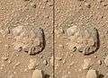 "Nova" rock on Mars – 1st laser spark imaged (Curiosity rover; July 12, 2014; video (01:07)).
 "Nova" rock on Mars – ChemCam spectra (Curiosity rover; July 12, 2014).
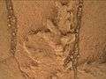 "Pahrump Hills" rock outcrop on Mars – viewed by Curiosity (September 23, 2014).
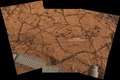 "Pahrump Hills" bedrock on Mars - viewed by Curiosity (November 9, 2014).
 "Pahrump Hills" sand - viewed by Curiosity (November 13, 2014).
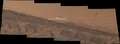 "Pahrump Hills" sand - Curiosity's tracks (November 7, 2014).
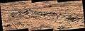 "Pink Cliffs" rock outcrop on Mars - viewed by Curiosity (October 7, 2014).
 "Point Lake" rock outcrop (detail) on Mars – viewed by Curiosity (June 13, 2013; context).
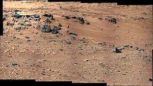

 Sand tracks – uncover finer grains (Curiosity rover; December 3, 2015).
- "Rocknest 3" rock on Mars – as viewed by the MastCam on Curiosity (October 5, 2012).
 "Sayunei" rock on Mars – Curiosity's view at night (January 22, 2013; wh light).
 "Sayunei" rock on Mars – Curiosity's view at night (January 22, 2013; uv light).
 "Shaler" rock outcrop on Mars – as viewed by the MastCam on the Curiosity rover (December 7, 2012).
 "Sheepbed" rock outcrop on Mars – as viewed by the MastCam on Curiosity (December 13, 2012).
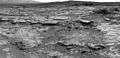 "Snake River" rock feature on Mars – as viewed by Curiosity (December 20, 2012).[18]
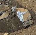 "Sutton Inlier" rock on Mars – broken by the Curiosity rover (January 31, 2013).[13]
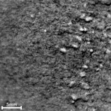
 "Unnamed-20120902" rock on Mars – as viewed by the Curiosity rover (September 2, 2012).
 "Wernecke" rock on Mars – cleaned with Curiosity's "Dust Removal Tool" (DRT) (January 26, 2013).[13]
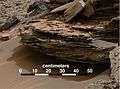 "Whale" rock on Mars - cross-bedding due to passage of water - as viewed by Curiosity (November 2, 2014).
 "Windjana" sandstone on Mars - as viewed by the Curiosity rover (Kimberley; April 23, 2014; context).
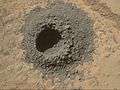 "Windjana" sandstone on Mars - drill hole (1.6 cm (0.63 in)) made by Curiosity (Kimberley; April 29, 2014).
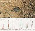 "Winnipesaukee" rock on Mars - target of the ChemCam laser analyzer on Curiosity (June 8, 2014).
 "Yellowjacket" rock on Mars – as viewed by the Curiosity rover (May 15, 2015).


Other rock formations
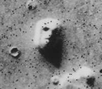 "Face on Mars" – due to Sun's lighting (Viking 1 orbiter; July 25, 1976)
(40°45′N 9°28′W / 40.75°N 9.46°W).

 Cave entrances (possible) on Mars (2001 Mars Odyssey; September 24, 2007).
 Mars monolith on Mars – rectangular boulder (MRO; July 24, 2008)
(7°13′52″S 267°21′00″E / 7.231°S 267.350°E). Oblong boulder on Mars – lands upright after rolling down a hill (MRO; July 3, 2014)
(31°S 302°E / 31°S 302°E).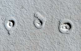 Rootless cones on Mars – due to lava flows interacting with water (MRO; January 4, 2013)
(21°57′54″N 197°48′25″E / 21.965°N 197.807°E).
See also
References
- 1 2 3 4 Williams, David R. Dr. (December 18, 2006). "Viking Mission to Mars". NASA. Retrieved February 2, 2014.
- ↑ Nelson, Jon. "Viking 1". NASA. Retrieved February 2, 2014.
- ↑ Nelson, Jon. "Viking 2". NASA. Retrieved February 2, 2014.
- ↑ Nelson, Jon. "Mars Pathfinder / Sojourner Rover". NASA. Retrieved February 2, 2014.
- ↑ Nelson, Jon. "Mars Exploration Rover - Spirit". NASA. Retrieved February 2, 2014.
- 1 2 Staff. "Mapping the Mars Rovers' Landing Sites". Esri. Retrieved May 4, 2014.
- ↑ Nelson, Jon. "Mars Exploration Rover - Opportunity". NASA. Retrieved February 2, 2014.
- ↑ Chang, Kenneth (7 June 2013). "Martian Rock Another Clue to a Once Water-Rich Planet". New York Times. Retrieved 7 June 2013.
- 1 2 3 O'Neill, Ian (January 17, 2014). "Mystery Rock 'Appears' in Front of Mars Rover". Space.com. Retrieved January 18, 2014.
- 1 2 3 Chang, Kenneth (January 24, 2014). "Mars Rover Marks an Unexpected Anniversary With a Mysterious Discovery". New York Times. Retrieved January 24, 2014.
- ↑ Nelson, Jon. "Phoenix". NASA. Retrieved February 2, 2014.
- ↑ Nelson, Jon. "Mars Science Laboratory Curiosity Rover". NASA. Retrieved February 2, 2014.
- 1 2 3 4 5 6 7 8 9 Webster, Guy; Brown, Dwayne (March 18, 2013). "Curiosity Mars Rover Sees Trend In Water Presence". NASA. Retrieved March 20, 2013.
- ↑ Staff (December 3, 2012). "A Sampling of Martian Soils". NASA. Retrieved December 3, 2012.
- ↑ Staff (November 22, 2012). "Thanksgiving on Mars: Working Holiday for Curiosity Rover". Space.com. Retrieved November 22, 2012.
- ↑ Staff (December 11, 2012). "PIA16550: Layered Martian Outcrop 'Shaler' in 'Glenelg' Area". NASA. Retrieved December 12, 2012.
- ↑ Hoagland, Richard C. (December 4, 2012). "NASA Announces Curiosity Rover To Investigate Mysterious Linear Features, Called "Shaler"". Enterprise Mission. Retrieved March 17, 2013.
- 1 2 Staff (January 4, 2013). "PIA16564: 'Snake River' Rock Feature Viewed by Curiosity Mars Rover". NASA. Retrieved January 4, 2013.
- 1 2 3 Rincon, Paul (March 19, 2013). "Curiosity breaks rock to reveal dazzling white interior". BBC. Retrieved March 19, 2013.
- 1 2 Webster, Guy; Brown, Dwayne; Cantillo, Laurie (November 2, 2016). "Curiosity Mars Rover Checks Odd-looking Iron Meteorite". NASA. Retrieved November 2, 2016.
- ↑ Anderson, Paul Scott (February 3, 2013). "Curiosity 'hammers' a rock and completes first drilling tests". The Meridiani Journal. Retrieved February 3, 2013.
- ↑ Brown, Dwayne (October 30, 2012). "NASA Rover's First Soil Studies Help Fingerprint Martian Minerals". NASA. Retrieved October 31, 2012.
External links
| Wikimedia Commons has media related to Rocks on Mars. |
- Mars - Geologic Map (USGS, 2014) (original / crop / full / video (00:56)).
- Rocks on Mars (Geology.com)
- MPF Rock Names
- Named Rocks on Mars (ppt file)
- NASA – Mars Exploration Program
- Minerals and the Origins of Life (Robert Hazen, NASA) (video, 60m, April 2014).
| General | 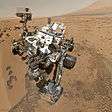 | |
|---|---|---|
| Instruments | ||
| Features | ||
| Sites | ||
| Rocks | ||
| ||
| Current | 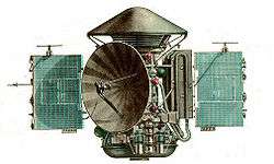  .jpg) .jpg) | ||||||||||||||||||
|---|---|---|---|---|---|---|---|---|---|---|---|---|---|---|---|---|---|---|---|
| Past |
| ||||||||||||||||||
| Failed at launch | |||||||||||||||||||
| Planned |
| ||||||||||||||||||
| Proposed | |||||||||||||||||||
| Cancelled / concepts | |||||||||||||||||||
| Related |
| ||||||||||||||||||
† indicates failure en route or before intended mission data returned. | |||||||||||||||||||
Mars Exploration Rover program | ||
|---|---|---|
| General |
|  |
| Spirit rover | ||
| Opportunity rover | ||
| Instruments |
| |
| Related |
| |
| Other | ||