Argyre quadrangle
|
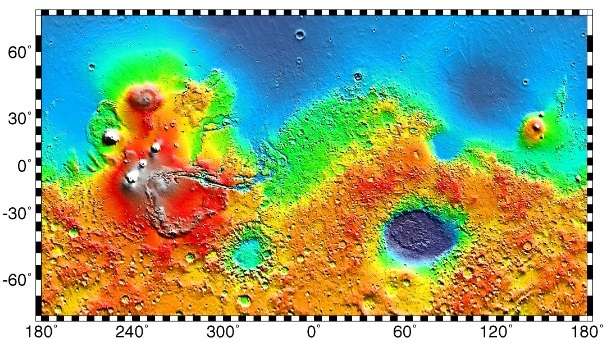
Map of Argyre quadrangle from Mars Orbiter Laser Altimeter (MOLA) data. The highest elevations are red and the lowest are blue. | |
| Coordinates | 47°30′S 30°00′W / 47.5°S 30°WCoordinates: 47°30′S 30°00′W / 47.5°S 30°W |
|---|---|


The Argyre quadrangle is one of a series of 30 quadrangle maps of Mars used by the United States Geological Survey (USGS) Astrogeology Research Program. The Argyre quadrangle is also referred to as MC-26 (Mars Chart-26).[1] It contains Argyre Planitia and part of Noachis Terra.
The Argyre quadrangle covers the area from 0° to 60° west longitude and from 30° to 65° south latitude on Mars. It contains Galle crater, which resembles a smiley face and the Argyre basin, a giant impact crater. Research published in the journal Icarus has found pits in Hale Crater that are caused by hot ejecta falling on ground containing ice. The pits are formed by heat forming steam that rushes out from groups of pits simultaneously, thereby blowing away from the pit ejecta.[2] Many steep slopes in this quadrangle contain gullies, which are believed to have formed by relatively recent flows of water.
Martian gullies
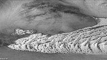
Gullies are common in some latitude bands on Mars. Usually, martian gullies are found on the walls of craters or troughs, but Charitum Montes, a group of mountains, has gullies in some areas (See the image below).
Gullies occur on steep slopes, especially on the walls of craters. Gullies are believed to be relatively young because they have few, if any craters. Moreover, they lie on top of sand dunes which themselves are considered to be quite young. Usually, each gully has an alcove, channel, and apron. Some studies have found that gullies occur on slopes that face all directions,[3] others have found that the greater number of gullies are found on poleward facing slopes, especially from 30-44 S.[4][5]
Although many ideas have been put forward to explain them,[6] the most popular involve liquid water coming from an aquifer, from melting at the base of old glaciers, or from the melting of ice in the ground when the climate was warmer.[7][8] Because of the good possibility that liquid water was involved with their formation and that they could be very young, scientists are excited. Maybe the gullies are where we should go to find life.
There is evidence for all three theories. Most of the gully alcove heads occur at the same level, just as one would expect of an aquifer. Various measurements and calculations show that liquid water could exist in aquifers at the usual depths where gullies begin.[7] One variation of this model is that rising hot magma could have melted ice in the ground and caused water to flow in aquifers. Aquifers are layer that allow water to flow. They may consist of porous sandstone. The aquifer layer would be perched on top of another layer that prevents water from going down (in geological terms it would be called impermeable). Because water in an aquifer is prevented from going down, the only direction the trapped water can flow is horizontally. Eventually, water could flow out onto the surface when the aquifer reaches a break—like a crater wall. The resulting flow of water could erode the wall to create gullies.[9] Aquifers are quite common on Earth. A good example is "Weeping Rock" in Zion National Park Utah.[10]
As for the next theory, much of the surface of Mars is covered by a thick smooth mantle that is thought to be a mixture of ice and dust.[11][12][13] This ice-rich mantle, a few yards thick, smoothes the land, but in places it has a bumpy texture, resembling the surface of a basketball. The mantle may be like a glacier and under certain conditions the ice that is mixed in the mantle could melt and flow down the slopes and make gullies.[14][15][16] Because there are few craters on this mantle, the mantle is relatively young. An excellent view of this mantle is shown below in the picture of the Ptolemaeus Crater Rim, as seen by HiRISE.[17] The ice-rich mantle may be the result of climate changes.[18] Changes in Mars's orbit and tilt cause significant changes in the distribution of water ice from polar regions down to latitudes equivalent to Texas. During certain climate periods water vapor leaves polar ice and enters the atmosphere. The water comes back to ground at lower latitudes as deposits of frost or snow mixed generously with dust. The atmosphere of Mars contains a great deal of fine dust particles. Water vapor will condense on the particles, then fall down to the ground due to the additional weight of the water coating. When Mars is at its greatest tilt or obliquity, up to 2 cm of ice could be removed from the summer ice cap and deposited at midlatitudes. This movement of water could last for several thousand years and create a snow layer of up to around 10 meters thick.[19][20] When ice at the top of the mantling layer goes back into the atmosphere, it leaves behind dust, which insulating the remaining ice.[21] Measurements of altitudes and slopes of gullies support the idea that snowpacks or glaciers are associated with gullies. Steeper slopes have more shade which would preserve snow.[4][5] Higher elevations have far fewer gullies because ice would tend to sublimate more in the thin air of the higher altitude.[22]
The third theory might be possible since climate changes may be enough to simply allow ice in the ground to melt and thus form the gullies. During a warmer climate, the first few meters of ground could thaw and produce a "debris flow" similar to those on the dry and cold Greenland east coast.[23] Since the gullies occur on steep slopes only a small decrease of the shear strength of the soil particles is needed to begin the flow. Small amounts of liquid water from melted ground ice could be enough.[24][25] Calculations show that a third of a mm of runoff can be produced each day for 50 days of each Martian year, even under current conditions.[26]
-

Gullies on the western rim of Argyra Planitia as seen with CTX.
-

Charitum Montes Gullies, as seen by HiRISE.
-

Gullies in Green Crater, as seen by HiRISE.
-

Close-up of gullies in Green Crater, as seen by HiRISE.
-

Jezza Crater,as seen by HiRISE. North wall (at top) has gullies. Dark lines are dust devil tracks. Scale bar is 500 meters long.
-
Gullies, as seen by HiRISE under HiWish program. Location is Nereidum Montes.
-
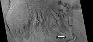
Scene in Argyre quadrangle with gullies, alluvival fans, and hollows, as seen by HiRISE under HiWish program. Enlargements of parts of this image are below.
-
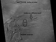
Several levels of alluvial fans, as seen by HiRISE under HiWish program. Locations of these fans are indicated in the previous image.
-
Small, well-formed alluvial fan, as seen by HiRISE under HiWish program. Location of this fan is shown in an image displayed above.
-
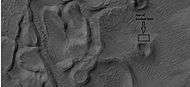
Enlargement of above image showing hollows with box showing the size of a football field, as seen by HiRISE under HiWish program.
-

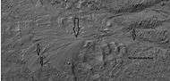
Gullies as seen by HiRISE under HiWish program.
-

Gullies in Nereidum Montes, as seen by HiRISE under HiWish program.
-

Gullies in a crater, as seen by HiRISE under HiWish program
-

Close up of gully aprons, as seen by HiRISE under HiWish program Note this is an enlargement of the previous image of gullies in a crater.
-

Wide view of gullies in Arkhangelsky Crater, as seen by HiRISE under HiWish program
-

Close-up of small channels in gullies in Arkhangelsky Crater, as seen by HiRISE under HiWish program Patterned ground in the shape of polygons can be seen to the right. Note: this is an enlargement of the previous image from Arkhangelsky Crater.
-

Close-up of a gully showing a channel going across the apron, as seen by HiRISE under HiWish program. Note: this is an enlargement of a previous image from Arkhangelsky Crater.
-

Gullies in crater, as seen by HiRISE under HiWish program
-

Close view of gullies from previous image The channels are quite curved. Because channels of gullies often form curves, it was thought that they were made by flowing water. Today, it is thought that they could be produced with chunks of dry ice. The image is from HiRISE under HiWish program.
Argyre basin
The Argyre basin was created by a giant impact that occurred 70 million years after the Hellas impact.[27] It is believed to have contained a lake early in the history of Mars.[28] At least three river valleys (Surius Vallis, Dzigal Vallis, and Palacopus Vallis) drain into it from the south. After it froze solid, the ice formed eskers which are visible today.[29][30] An article written by 22 researchers in Icarus concluded that the impact that formed the Argyre basin probably stuck an ice cap or a thick permafrost layer. Energy from the impact melted the ice and formed a giant lake that eventually sent water to the North. The lakes's volume was equal to that of Earth's Mediterranean Sea. The deepest part of the lake may have taken more than a hundred thousand years to freeze, but with the help of heat from the impact, geothermal heating, and dissolved solutes it may have had liquid water for many millions of years. Life may have developed in this time. This region shows a great deal of evidence of glacial activity with flow features, crevasse-like fractues, drumlines, eskers, tarns, aretes, cirques, horns, U-shaped valleys, and terraces. Because of the shapes of Argyre sinuous ridges, the authors concluded that they are eskers.[31] Studies with advanced cameras, such as CTX, and MRO High Resolution Imaging Science Experiment (HiRISE) suggests that these ridges are probably eskers.[32][33]
-
Topography of the Argyre basin, the major feature in the Argyre quadrangle.
Galle (Martian crater)
-

Galle Crater, also called Happy-Face Crater, as seen by Mars Global Surveyor
-

Part of Galle Crater, as seen by CTX camera (on Mars Reconnaissance Orbiter). The right eye and mouth are labeled. One of two dune fields are labeled as well.
-

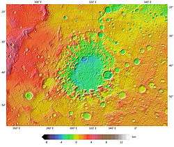
Wide view of area around Galle Crater Colors show elevations.
-

Region around Galle Crater Colors show elevations.
-

Galle Crater Colors show elevations. Arrow indicates a layered mound that is enlarged in other images to follow.
-

Wide CTX view of part of layered mound. Parts of this mound are enlarged in HiRISE images that follow.
-

HiRISE image from area in previous image Picture taken under HiWish program.
-

Layers in mound in Galle Crater, as seen by HiRISE under HiWish program
-

Layers in mound in Galle Crater, as seen by HiRISE under HiWish program
-

Layers in mound in Galle Crater, as seen by HiRISE under HiWish program
-

Layers breaking up into boulders in Galle Crater, as seen by HiRISE under HiWish program
-

Layers and gullies in Galle Crater, as seen by HiRISE under HiWish program
-

Close view of layers in mound in Galle Crater, as seen by HiRISE under HiWish program
-

Layered mesa in mound in Galle Crater, as seen by HiRISE under HiWish program
-

Layers and polygons in mound in Galle Crater, as seen by HiRISE under HiWish program
-

Close view of layers in mound in Galle Crater, as seen by HiRISE under HiWish program
Other craters
Impact craters generally have a rim with ejecta around them, in contrast volcanic craters usually do not have a rim or ejecta deposits. As craters get larger (greater than 10 km in diameter) they usually have a central peak.[34] The peak is caused by a rebound of the crater floor following the impact.[35] Often, craters with diameters greater than 100 km have rings on their floors. Since so much material is blasted away, the ground readjusts, making circular faults. When lava flows upward along the faults, rings are produced.[36] Sometimes craters will display layers. Since the collision that produces a crater is like a powerful explosion, rocks from deep underground are tossed unto the surface. Hence, craters can show us what lies deep under the surface.
-

Wirtz Crater Dunes with ripples and frost, as seen by HiRISE.
-

Bond Crater Floor, as seen by HiRISE.
-

Hartwig Crater Floor, as seen by HiRISE. The scale bar is 500 meters long.
-

Baltisk Crater Floor,as seen by HiRISE. Scale bar is 1000 meters long. Dark dunes are visible at the bottom of image on the left.
-

Lohse Crater Gullies on Central Peak, as seen by HiRISE.
-

Arkhangelsky Crater Dunes, as seen by THEMIS. Click on image to see possible gullies on central peak.
-

East side of Halley Crater, as seen by CTX camera (on Mars Reconnaissance Orbiter).
-

Floor of Halley Crater, as seen by CTX camera (on Mars Reconnaissance Orbiter). Thin dark lines are dust devil tracks. Note: this is an enlargement of the previous image of Halley Crater.
-
West side of Vogel Crater, as seen by CTX camera (on Mars Reconnaissance Orbiter).
-

Hooke Crater, as seen by CTX camera (on Mars Reconnaissance Orbiter). Dark places are dunes.
-

Dust devil tracks in and around Hooke Crater, as seen by CTX camera (on Mars Reconnaissance Orbiter). Note: this is an enlargement of the previous image of Hooke Crater.
-

Dunes and gullies in Hooke Crater, as seen by CTX camera (on Mars Reconnaissance Orbiter). Note: this is an enlargement of a previous image of Hooke Crater.
-

Dunes and dust devil tracks in Hooke Crater, as seen by HiRISE. There are also gullies just visible.
-
Jones Crater, as seen by CTX camera (on Mars Reconnaissance Orbiter). Regions on the floor containing layers, fans, and dunes are labeled.
-

Fan, layers, and dunes on the floor of Jones Crater, as seen by CTX camera (on Mars Reconnaissance Orbiter). Note: this is an enlargement of the previous image of Jones Crater.
-

Maraldi Crater, as seen by CTX camera (on Mars Reconnaissance Orbiter).
-

Dust devil tracks just outside rim of Maraldi Crater, as seen by CTX camera (on Mars Reconnaissance Orbiter). Note: this is an enlargement of the previous image of Maraldi Crater.
-

East side of Helmholtz Crater, as seen by CTX camera (on Mars Reconnaissance Orbiter).
-
Dunes and dust devil tracks in Helmholtz Crater, as seen by CTX camera (on Mars Reconnaissance Orbiter). Note: this is an enlargement of the previous image of Helmholtz Crater.
-

Wegener Crater, as seen by CTX camera (on Mars Reconnaissance Orbiter).
-

Wegener Crater showing dunes defrosting, as seen by CTX camera (on Mars Reconnaissance Orbiter). Dark spots are places where frost has disappeared from the dark dunes. Note: this is an enlargement of the previous image of Wegener Crater.
-

Von Karman Crater, as seen by CTX camera (on Mars Reconnaissance Orbiter). Dark parts near the top are dunes.
-
Defrosting dunes in Von Karman Crater, as seen by CTX camera (on Mars Reconnaissance Orbiter). Dark places are where frost has left dark dunes. Picture taken in the springtime on Mars.
Gallery
-

Map of Argyre quadrangle with major features labeled. Galle crater looks like a smile.
-

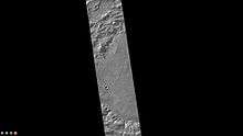
Surface in Argyre quadrangle as seen by HiRISE, under the HiWish program. This is the image of the surface from a single HiRISE image. The scale bar at the top is 500 meters long.
-

CTX image showing context for the next image. A group of channels are visible in this image.
-

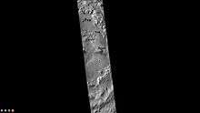
Close-up of surface in Argyre quadrangle, as seen by HiRISE, under the HiWish program.
-

Dust devil tracks as seen by HiRISE under HiWish program
-

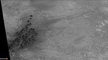
Layers exposed in Nereidum Montes, as seen by HiRISE under HiWish program The light-toned layers may contain sulfates which are good for preserving traces of ancient life.
-
Close-up of layers from previous image, as seen by HiRISE under HiWish program
-

Low, layered mesa, as seen by HiRISE under HiWish program Arrows point to some layers.
-

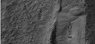
Channel, as seen by HiRISE under HiWish program
Other Mars quadrangles
Interactive Mars map
See also
References
- ↑ Davies, M.E.; Batson, R.M.; Wu, S.S.C. "Geodesy and Cartography" in Kieffer, H.H.; Jakosky, B.M.; Snyder, C.W.; Matthews, M.S., Eds. Mars. University of Arizona Press: Tucson, 1992.
- ↑ Tornabene, L.; et al. (2012). "Widespread crater-related pitted materials on Mars. Further evidence for the role of target volatiles during the impact process". Icarus. 220: 348–368. Bibcode:2012Icar..220..348T. doi:10.1016/j.icarus.2012.05.022.
- ↑ Edgett, K. et al. 2003. Polar-and middle-latitude martian gullies: A view from MGS MOC after 2 Mars years in the mapping orbit. Lunar Planet. Sci. 34. Abstract 1038.
- 1 2 http://www.planetary.brown.edu/pdfs/3138.pdf
- 1 2 Dickson, J.; et al. (2007). "Martian gullies in the southern mid-latitudes of Mars Evidence for climate-controlled formation of young fluvial features based upon local and global topography". Icarus. 188: 315–323. Bibcode:2007Icar..188..315D. doi:10.1016/j.icarus.2006.11.020.
- ↑ "PSRD: Gullied Slopes on Mars". Retrieved 26 December 2014.
- 1 2 Heldmann, J.; Mellon, M. (2004). "Observations of martian gullies and constraints on potential formation mechanisms". Icarus. 168: 285–304. Bibcode:2004Icar..168..285H. doi:10.1016/j.icarus.2003.11.024.
- ↑ Forget, F. et al. 2006. Planet Mars Story of Another World. Praxis Publishing. Chichester, UK.
- ↑ "Mars Gullies Likely Formed By Underground Aquifers". Space.com. Retrieved 26 December 2014.
- ↑ Harris, A and E. Tuttle. 1990. Geology of National Parks. Kendall/Hunt Publishing Company. Dubuque, Iowa
- ↑ Malin, M.; Edgett, K. (2001). "Mars Global Surveyor Mars Orbiter Camera: Interplanetary cruise through primary mission". J. Geophys. Res. 106: 23429–23570. Bibcode:2001JGR...10623429M. doi:10.1029/2000je001455.
- ↑ Mustard, J.; et al. (2001). "Evidence for recent climate change on Mars from the identification of youthful near-surface ground ice". Nature. 412: 411–414. doi:10.1038/35086515.
- ↑ Carr, M (2001). "Mars Global Surveyor observations of fretted terrain". J. Geophys. Res. 106: 23571–23595. Bibcode:2001JGR...10623571C. doi:10.1029/2000je001316.
- ↑ "Martian gullies could be scientific gold mines". msnbc.com. Retrieved 26 December 2014.
- ↑ "Formation of gullies on Mars: Link to recent climate history and insolation microenvironments implicate surface water flow origin". Retrieved 26 December 2014.
- ↑ Head, J.; et al. (2008). "Formation of gullies on Mars: Link to recent climate history and insolation microenvironments implicate surface water flow origin". PNAS. 105: 13258–13263. doi:10.1073/pnas.0803760105.
- ↑ Christensen, P (2003). "Formation of recent martian gullies through melting of extensive water-rich snow deposits". Nature. 422: 45–48. doi:10.1038/nature01436.
- ↑ "Melting Snow Created Mars Gullies, Expert Says". Retrieved 26 December 2014.
- ↑ Jakosky, B.; Carr, M. (1985). "Possible precipitation of ice at low latitudes of Mars during periods of high obliquity". Nature. 315: 559–561. doi:10.1038/315559a0.
- ↑ Jakosky, B.; et al. (1995). "Chaotic obliquity and the nature of the Martian climate". J. Geophys. Res. 100: 1579–1584. Bibcode:1995JGR...100.1579J. doi:10.1029/94je02801.
- ↑ MLA NASA/Jet Propulsion Laboratory (2003, December 18). Mars May Be Emerging From An Ice Age. ScienceDaily. Retrieved February 19, 2009, from http://www.sciencedaily.com /releases/2003/12/031218075443.htmAds by GoogleAdvertise
- ↑ Hecht, M (2002). "Metastability of liquid water on Mars". Icarus. 156: 373–386. Bibcode:2002Icar..156..373H. doi:10.1006/icar.2001.6794.
- ↑ Peulvast, J. Physio-Geo. 18. 87-105.
- ↑ Costard, F. et al. 2001. Debris Flows on Mars: Analogy with Terrestrial Periglacial Environment and Climatic Implications. Lunar and Planetary Science XXXII (2001). 1534.pdf
- ↑ http://www.spaceref.com:16090/news/viewpr.html?pid=7124,
- ↑ Clow, G (1987). "Generation of liquid water on Mars through the melting of a dusty snowpack". Icarus. 72: 93–127.
- ↑ Robbins; et al. (2013). "large impact crater histories of Mars: The effect of different model crater age techniques". Icarus. 225: 173–184. Bibcode:2013Icar..225..173R. doi:10.1016/j.icarus.2013.03.019.
- ↑ Parker, T. et al. 2000. Argyre Planitia and the Mars global hydrolocia cycle. LPSC XXXI. Abstract 2033
- ↑ Kargel,J. and R. Strom. 1991. Terrestrial glacial eskers: analogs for martian sinuous ridges. LPSC XXII, 683-684.
- ↑ Michael H. Carr (2006). The surface of Mars. Cambridge University Press. ISBN 978-0-521-87201-0. Retrieved 21 March 2011.
- ↑ Dohm, J.; Hare, T.; Robbins, S.; Williams, J.-P.; Soare, R.; El-Maarry, M.; Conway, S.; Buczkowski, D.; Kargel, J.; Banks, M.; Fairén, A.; Schulze-Makuch, D.; Komatsu, G.; Miyamoto, H.; Anderson, R.; Davila, A.; Mahaney, W.; Fink, W.; Cleaves, H.; Yan, J.; Hynek, B.; Maruyama, S. (2015). "Geological and hydrological histories of the Argyre province, Mars". Icarus. 253: 66–98. Bibcode:2015Icar..253...66D. doi:10.1016/j.icarus.2015.02.017.
- ↑ Banks, M.; Lang, N.; Kargel, J.; McEwen, A.; Baker, V.; Grant, J.; Pelletier, J.; Strom, R. (2009). "An analysis of sinuous ridges in the southern Argyre Planitia, Mars using HiRISE and CTX images and MOLA data". J. Geophys. Res. 114. Bibcode:2009JGRE..114.9003B. doi:10.1029/2008JE003244.
- ↑ Bernhardt, H.; Hiesinger, H.; Reiss, D.; Ivanov, M.; Erkeling, G. (2013). "Putative eskers and new insights into glacio-fluvial depositional settings southern Argyre Planitia, Mars". Planet. Space Sci. 85: 261–278. Bibcode:2013P&SS...85..261B. doi:10.1016/j.pss.2013.06.022.
- ↑ "Stones, Wind, and Ice: A Guide to Martian Impact Craters". Retrieved 26 December 2014.
- ↑ Hugh H. Kieffer (1992). Mars. University of Arizona Press. ISBN 978-0-8165-1257-7. Retrieved 7 March 2011.
- ↑ Forget, F. et al. 2006. Planet Mars Story of Another World. Praxis Publishing. Chichester, UK
- 1 2 Morton, Oliver (2002). Mapping Mars: Science, Imagination, and the Birth of a World. New York: Picador USA. p. 98. ISBN 0-312-24551-3.
- ↑ "Online Atlas of Mars". Ralphaeschliman.com. Retrieved December 16, 2012.
- ↑ "PIA03467: The MGS MOC Wide Angle Map of Mars". Photojournal. NASA / Jet Propulsion Laboratory. February 16, 2002. Retrieved December 16, 2012.
- ↑ "Online Atlas of Mars". Ralphaeschliman.com. Retrieved December 16, 2012.
- ↑ "PIA03467: The MGS MOC Wide Angle Map of Mars". Photojournal. NASA / Jet Propulsion Laboratory. February 16, 2002. Retrieved December 16, 2012.
External links
| Wikimedia Commons has media related to Argyre quadrangle. |
- General review of many of the theories involving the origin of gullies.
- Good review of the history of the discovery of gullies.
- Lakes on Mars - Nathalie Cabrol (SETI Talks)
| Quadrangles on Mars | ||||||||||||||||||||||||||||||||||||||||||||||||||||||||||||||||||||||||||||||||||||||||||||||||||||||||||||||||||||||||||||||||||||||||||||||||
|---|---|---|---|---|---|---|---|---|---|---|---|---|---|---|---|---|---|---|---|---|---|---|---|---|---|---|---|---|---|---|---|---|---|---|---|---|---|---|---|---|---|---|---|---|---|---|---|---|---|---|---|---|---|---|---|---|---|---|---|---|---|---|---|---|---|---|---|---|---|---|---|---|---|---|---|---|---|---|---|---|---|---|---|---|---|---|---|---|---|---|---|---|---|---|---|---|---|---|---|---|---|---|---|---|---|---|---|---|---|---|---|---|---|---|---|---|---|---|---|---|---|---|---|---|---|---|---|---|---|---|---|---|---|---|---|---|---|---|---|---|---|---|---|---|
| ||||||||||||||||||||||||||||||||||||||||||||||||||||||||||||||||||||||||||||||||||||||||||||||||||||||||||||||||||||||||||||||||||||||||||||||||