Lovatnet
| Lovatnet | |
|---|---|
 Lovatnet | |
| Location | Stryn (Sogn og Fjordane) |
| Coordinates | 61°50′19″N 06°56′01″E / 61.83861°N 6.93361°E / 61.83861; 6.93361Coordinates: 61°50′19″N 06°56′01″E / 61.83861°N 6.93361°E / 61.83861; 6.93361 |
| Primary inflows | Kjenndalselva river |
| Primary outflows | Loelva river |
| Basin countries | Norway |
| Surface area | 10.49 km2 (4.05 sq mi) |
| Shore length1 | 26.98 km (16.76 mi) |
| Surface elevation | 52 m (171 ft) |
| References | NVE |
| 1 Shore length is not a well-defined measure. | |
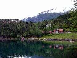
Lovatnet is a lake in the municipality of Stryn in Sogn og Fjordane county, Norway. It is located about 2 kilometres (1.2 mi) southeast of the village of Loen and about 6 kilometres (3.7 mi) east of the village of Olden. The lake lies just 2 kilometres (1.2 mi) southwest of the mountain Skåla. The water from the lake flows down from the mountains; especially from the Jostedalsbreen and Tindefjellbreen glaciers. It then flows out through the Loelva river into the Nordfjorden.[1]
See also
References
- ↑ Store norske leksikon. "Lovatnet" (in Norwegian). Retrieved 2010-07-23.
This article is issued from Wikipedia - version of the 9/4/2015. The text is available under the Creative Commons Attribution/Share Alike but additional terms may apply for the media files.