Kalandsvatnet
| Kalandsvatnet | |
|---|---|
 | |
| Location | Bergen, Hordaland |
| Coordinates | 60°16′20″N 5°23′55″E / 60.2721°N 5.3986°E / 60.2721; 5.3986Coordinates: 60°16′20″N 5°23′55″E / 60.2721°N 5.3986°E / 60.2721; 5.3986 |
| Basin countries | Norway |
| Max. length | 3 kilometres (1.9 mi) |
| Max. width | 2.66 kilometres (1.65 mi) |
| Surface area | 3.5 km2 (1.4 sq mi) |
| Shore length1 | 12.39 kilometres (7.70 mi) |
| Surface elevation | 53 metres (174 ft) |
| References | NVE |
| 1 Shore length is not a well-defined measure. | |
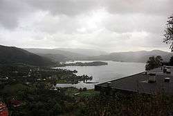
Kalandsvatnet is the largest lake in the municipality of Bergen in Hordaland county, Norway. The 3.5-square-kilometre (1.4 sq mi) lake is located in the borough of Fana, just east of the village of Fanahammeren. The European route E39 highway runs along the northeastern shore of the lake, about 12 kilometres (7.5 mi) south of the city centre of Bergen.[1]
See also
References
- ↑ "Kalandsvatnet" (in Norwegian). Bergens byarkiv. Retrieved 2014-09-17.
This article is issued from Wikipedia - version of the 9/18/2014. The text is available under the Creative Commons Attribution/Share Alike but additional terms may apply for the media files.