Holsavatnet
| Holsavatnet | |
|---|---|
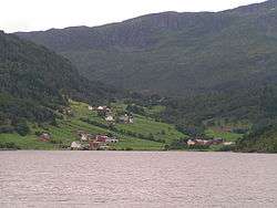 View of the lake, seen from Nyddalen | |
| Location | Førde (Sogn og Fjordane) |
| Coordinates | 61°25′N 6°06′E / 61.417°N 6.100°E / 61.417; 6.100Coordinates: 61°25′N 6°06′E / 61.417°N 6.100°E / 61.417; 6.100 |
| Primary inflows | Skorpaelva river and Nyddalselva river |
| Primary outflows | Åsvatnet lake |
| Basin countries | Norway |
| Surface area | 3.33 km2 (1.29 sq mi) |
| Shore length1 | 16.78 km (10.43 mi) |
| Surface elevation | 131 m (430 ft) |
| References | NVE |
| 1 Shore length is not a well-defined measure. | |
Holsavatnet is a lake which lies in the municipality of Førde in Sogn og Fjordane county, Norway. The lake is located about 12 kilometres (7.5 mi) east of the town of Førde and about 9.5 kilometres (5.9 mi) east of the village of Bruland. The village of Holsen lies at the eastern end of the lake. The European route E39 highway passes 3 kilometres (1.9 mi) west of the lake. The lake eventually flows into the river Jølstra.[1]
See also
References
- ↑ Store norske leksikon. "Holsaelva" (in Norwegian). Retrieved 2010-08-06.
This article is issued from Wikipedia - version of the 9/4/2015. The text is available under the Creative Commons Attribution/Share Alike but additional terms may apply for the media files.