Mjøsa
| Mjøsa | |
|---|---|
 | |
| Location | Akershus, Hedmark, Oppland |
| Coordinates | 60°40′N 11°00′E / 60.667°N 11.000°ECoordinates: 60°40′N 11°00′E / 60.667°N 11.000°E |
| Primary inflows | Gudbrandsdalslågen |
| Primary outflows | Vorma |
| Basin countries | Norway |
| Max. length | 117 km |
| Max. width | 15 km |
| Surface area | 362 km²[1] |
| Average depth | 155 m[1] |
| Max. depth | 449 m[1] (other sources give 468 m) |
| Water volume | 56.0 km³[1] |
| Surface elevation | 121 m[1] (other sources give 123 m) |
| Islands | Helgøya |
| Settlements | Hamar, Gjøvik, Lillehammer |
| References | [1] |

From its southernmost point at Minnesund in Eidsvoll to its northernmost point in Lillehammer it is 117 km long. At its widest, near Hamar, it is 15 km wide. It is 365 km² in area and its volume is estimated at 56 km³; normally its surface is 123 metres above sea level, and its greatest depth is 468 metres. Its total coastline is estimated at 273 km, of which 30% is built up. Dams built on the distribuary of Vorma in 1858, 1911, 1947, and 1965 raised the level by approximately 3.6 metres in total. In the last 200 years, 20 floods have been registered that added 7 metres to the level of Mjøsa. Several of these floods inundated the city of Hamar.
The cities of Hamar, Gjøvik, and Lillehammer were founded along the shores of the lake. Before the construction of railways past the lake, it was an important transport route. Today, aside from minor leisure boating and the steamship Skibladner, there is no water traffic on the lake. Most of its shores are dominated by rolling agricultural areas, among them some of the most fertile grainlands in Norway. The main train line, Dovrebanen between Oslo and Trondheim goes along its eastern shore, making stops in Hamar and Lillehammer. The largest, and only, island is Helgøya. Except for Helgøya, Mjøsa only contains small islets. The most interesting of these are Steinsholmen, with the ruins of a Middle Age citadel.
From the south European route E6 runs along the eastern shore of the lake until the Mjøsa Bridge connects Moelv on the east with Biri on the west.
Fish
Lake Mjøsa has 20 species of fish. Among the most common are pike, European perch, common roach, greyling, and the hundertrout, a brown trout which can reach a weight more than 20 kg. Another common species is the European smelt, which is the most important baitfish for the predators. Historically, the most economically significant species is the lågsild (European cisco).
The name
The name (Norse Mjǫrs, Proto-Norse *Merso) must be very old. The meaning is, maybe, 'the bright/shiny one'. (If *mer- is related to the English word mere 'clear, bright', and -so is a suffix.)
 The lake seen from the harbor in Hamar
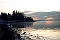 The landmark Geiteryggen looking south from Hamar
 Mjøsa from Hamar
 Steamboat Skibladner on the lake of Mjøsa
Events
In 1975, the 14th World Scout Jamboree was held on its shores. More than 17.000 Scouts from 91 countries took part.
In 1995, a Swedish team lifted a Halifax bomber that was shot down in World War II.
See also
Culture projects
| Wikimedia Commons has media related to Mjøsa. |