Breimsvatn
| Breimsvatnet | |
|---|---|
 | |
| Location |
Gloppen and Jølster, Sogn og Fjordane |
| Coordinates | 61°41′38″N 06°23′17″E / 61.69389°N 6.38806°ECoordinates: 61°41′38″N 06°23′17″E / 61.69389°N 6.38806°E |
| Primary outflows | Gloppeelva river |
| Basin countries | Norway |
| Max. length | 18 kilometres (11 mi) |
| Max. width | 2.7 kilometres (1.7 mi) |
| Surface area | 22.52 km2 (8.70 sq mi) |
| Max. depth | 278 metres (912 ft) |
| Shore length1 | 42.97 kilometres (26.70 mi) |
| Surface elevation | 61 metres (200 ft) |
| References | NVE |
| 1 Shore length is not a well-defined measure. | |
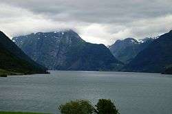
Breimsvatn or Breimsvatnet is a lake in the municipalities of Gloppen and Jølster in Sogn og Fjordane county, Norway. At 22.52 square kilometres (8.70 sq mi), it is the largest lake in Gloppen (followed by the lake Emhjellevatnet). The European route E39 highway runs along the north end of the lake, connecting the two nearby areas of Sandane and Byrkjelo. On the shores of the 17-kilometre (11 mi) long lake lie several villages including Re and Kandal. The lake flows into the Gloppenelva river which flows into the Gloppefjorden, an arm of the Nordfjorden. Historically, the area surrounding the lake was part of the municipality of Breim, which existed from 1886 until 1964.[1][2]
See also
References
- ↑ Store norske leksikon. "Breimsvatnet" (in Norwegian). Retrieved 2010-08-07.
- ↑ "Breimsvatnet" (in Norwegian). Sportsfiske.nu. Retrieved 2010-08-07.
External links
This article is issued from Wikipedia - version of the 11/7/2016. The text is available under the Creative Commons Attribution/Share Alike but additional terms may apply for the media files.