Ringedalsvatnet
| Ringedalsvatnet | |
|---|---|
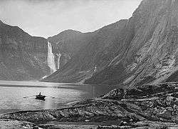 View of the lake with Ringedalsfossen in the background (c. 1885) | |
| Location | Odda, Hordaland |
| Coordinates | 60°07′21″N 6°39′21″E / 60.1226°N 6.6557°ECoordinates: 60°07′21″N 6°39′21″E / 60.1226°N 6.6557°E |
| Basin countries | Norway |
| Max. length | 8 kilometres (5.0 mi) |
| Max. width | 1 kilometre (0.62 mi) |
| Surface area | 7 km2 (2.7 sq mi) |
| Water volume | 426,000,000 m3 (557,000,000 cu yd) |
| Shore length1 | 465 kilometres (289 mi) |
| Surface elevation | 18.36 metres (60.2 ft) |
| References | NVE |
| 1 Shore length is not a well-defined measure. | |
Ringedalsvatnet is a lake in the municipality of Odda in Hordaland county, Norway. The 7-square-kilometre (2.7 sq mi) lake lies about 3.5 kilometres (2.2 mi) east (up the valley) from the village of Tyssedal, which sits on the shore of the Sørfjorden. The lake is the main reservoir for a hydroelectric power station in Tyssedal which provides electricity for the power intensive industries in the nearby town of Odda. The 521-metre (1,709 ft) wide and 33-metre (108 ft) high Ringedals Dam was constructed from 1910–1918.[1]
Due to the extensive regulation of the nearby lakes such as Langavatnet and Nybuvatnet in the mountains above this lake, several of the large waterfalls that once fed Ringedalsvatnet are no longer regularly flowing. The Tyssestrengene and Ringedalsfossen waterfalls were once very notable waterfalls on the cliffs surrounding this lake. The Trolltunga cliff overlooks this lake too, attracting many tourists and hikers each year.
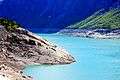 View of the lake, from the dam
 Tyssestrengene waterfall
 Ringedalsfossen
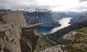 View of the Trolltunga outcropping
See also
References
- ↑ Store norske leksikon. "Ringedalsvatnet" (in Norwegian). Retrieved 2014-06-13.
External links
- Map of the lakes regulated by "Tyssefaldene" for hydropower plants