Hundred Islands National Park
| Hundred Islands National Park | |
|---|---|
|
IUCN category V (protected landscape/seascape) | |
|
View of some of the Hundred Islands | |
.svg.png) | |
| Location | Lingayen Gulf, Philippines |
| Nearest city | Alaminos, Pangasinan |
| Coordinates | 16°12′N 120°2′E / 16.200°N 120.033°ECoordinates: 16°12′N 120°2′E / 16.200°N 120.033°E |
| Area | 1,844 hectares (4,560 acres) |
| Established | January 18, 1940 |
| Governing body | Department of Environment and Natural Resources |
| http://www.hundredislands.ph/ | |
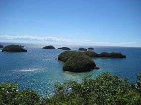
The Hundred Islands National Park (Pangasinan: Kapulo-puloan or Taytay-Bakes) is a national park in the Philippines. The protected area is located in the city of Alaminos, in the province of Pangasinan in northern Philippines. The islands, totaling 124 at low tide and 123 at high tide, are scattered in Lingayen Gulf covering an area of 16.76 square kilometres (6.47 sq mi). Only three of them have been developed for tourism: Governor Island, Quezon Island, and Children's Island. The Lucap wharf in Alaminos, the entrance to the National Park, is about 240 kilometres (150 mi) north of Manila, the capital of the Philippines.[1]
Geology

The islands are believed to be about two million years old. They are actually ancient corals that extend well inland, in an area previously comprising the seabed of an ancient sea. The lowering of the sea level have exposed them to the surface. The peculiar "mushroom-like" shapes of some of the islands were caused by the eroding action of the ocean waves.
History
The national park was created by Presidential Proclamation No. 667, covering an area of 16.76 square kilometres (6.47 sq mi) and signed by President Manuel L. Quezon on January 18, 1940, for the benefit and enjoyment of the people of the Philippines and known as the Hundred Islands National Park (HINP). The Republic Act No. 3655 signed on June 22, 1962, created the Hundred Islands Conservation and Development Authority (HICDA), for the conservation, development and management of HINP. The park including Lucap Bay was transferred from HICDA to the Philippine Tourism Authority (PTA) by virtue of Section 35 of Presidential Decree No. 564.[2]
On April 27, 1982 under Proclamation No. 2183, the national park including Lucap Bay and its foreshore areas, beginning from Sitio Telbang to the east to Sitio Recudo to the west, were declared as a Tourist Zone and Marine Reserve under the control and administration of the PTA. Subsequently under the Presidential Proclamation No. 2237 enacted on November 6, 1982, the parcels of land reserve for the Marine Fisheries Multi-Purpose Farm (created under Proclamation No. 1282 of June 21, 1974) were withdrawn and were also placed under the control and supervision of the Tourism Authority for development purposes.[2]
The Executive Order No. 436 signed by President Gloria Macapagal-Arroyo on June 21, 2005 transferred the administration, management, maintenance, and operation of the whole Hundred Islands National Park (HINP), including all the activities, facilities, and improvements thereafter, from the Philippine Tourism Authority (PTA) to the city government of Alaminos, Pangasinan in pursuit of Republic Act No. 7160, otherwise known as the Local Government Code of 1991, which encouraged the transfer of power and authority from the national government to local government units, in line with the government’s devolution program mandated by the Constitution.[2]
Cabarruyan Island
The Cabarruyan Island, the largest island in the island-municipality of Anda, Pangasinan located northwest of the National Park, is often referred to as the "mother island" of the Hundred Islands.

Fauna
The Sagip Lingayen Gulf Project is a study done in 2010, implemented by the Marine Environment and Resources Foundation Inc. and funded by the Dutch government, in response to the lack of resources on the terrestrial wildlife of the islands. The study assessed and created an inventory of the flora and fauna of the islands to help the city government create an environmental monitoring program to protect the island's biodiversity. Some of the wildlife found living in the National Park are:[3]
- Crab-eating macaque
- Common palm civet
- Dugong
- Fraser's dolphin
- Gecko
- Monitor lizard
- Sea turtles
- Green sea turtle
- Olive ridley sea turtle
- a species of Red turtle
- Snakes
- Laticauda colubrina, a species of sea snake
- Reticulated python
- Various bat species
- Various rodent species
Getting there
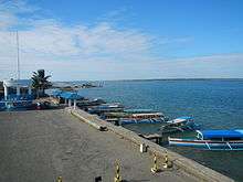
Lucap or Alaminos Wharf, the entrance to the National Park, is about 240 kilometres (150 mi) north from the Kilometer Zero marker in Rizal Park in Manila or about 3.75 hours drive by private vehicle.[1] By public transportation from Manila, the bus ride takes about 5 to 6 hours.[4]
Gallery
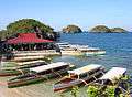 Quezon Island is one of the few developed tourist locations on Hundred Islands.
 Some of the islands as seen from the viewing point on Governor Island.
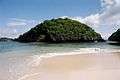 One of the islands of National Park
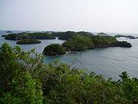 View of the other islands from the Governor island.
 Count Hundred Islands Monument
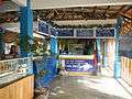 Tourism and registration office of the park
See also
References
- 1 2 "Rizal Park to Hundred Islands National Park". Google Maps. Retrieved on 2013-05-20.
- 1 2 3 "Executive Order No. 436". the LawPhil Project. Retrieved on 2013-05-20.
- ↑ Sotelo, Yolanda (2010-08-18). "Study finds no frogs in Hundred Islands". Inquirer.net.
- ↑ "Getting here". Hundred Islands National Park Official Website. Retrieved on 2013-05-20.
External links
| Wikimedia Commons has media related to Hundred Islands National Park. |