Islip, Oxfordshire
| Islip | |
 St. Nicholas the Confessor parish church |
|
 Islip |
|
| Area | 6.42 km2 (2.48 sq mi) |
|---|---|
| Population | 652 (2011 Census) |
| – density | 102/km2 (260/sq mi) |
| OS grid reference | SP5214 |
| Civil parish | Islip |
| District | Cherwell |
| Shire county | Oxfordshire |
| Region | South East |
| Country | England |
| Sovereign state | United Kingdom |
| Post town | Kidlington |
| Postcode district | OX5 |
| Dialling code | 01865 |
| Police | Thames Valley |
| Fire | Oxfordshire |
| Ambulance | South Central |
| EU Parliament | South East England |
| UK Parliament | Henley |
| Website | Islip Village Oxfordshire |
|
|
Coordinates: 51°49′23″N 1°14′10″W / 51.823°N 01.236°W
Islip /ˈaɪslɪp/ is a village and civil parish on the River Ray, just above its confluence with the River Cherwell in Oxfordshire, England. It is about 2 miles (3 km) east of Kidlington and about 5 miles (8 km) north of Oxford. The 2011 Census recorded the parish's population as 652.[1]
Archaeology
The remains of a Romano-British villa have been found about half a mile (800 metres) southwest of the village.[2]
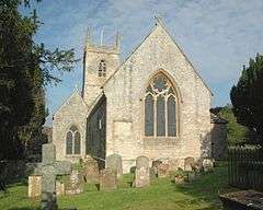
Parish church
Edward the Confessor (born circa 1004, died 1066) was born in Islip and tradition holds that he was baptised in a church here.[3] Parts of the present building date from about 1200.[4] The chancel was rebuilt in 1780 and the church was restored in 1861.[4] The church is Islip's only Grade I Listed Building.[5] The belltower has a ring of eight bells.[6] The Church of England parish is now part of the Benefice of the Ray Valley.[7]
A chapel associated with Edward the Confessor used to exist north of the church. The chapel was damaged in April 1645 in a military engagement in the English Civil War, and in the 1780s it was demolished.[4]
The former Rectory was built in 1689 for Robert South and enlarged in 1807 for William Vincent. It is Islip's only Grade II* Listed Building.[8]
Economic and social history

The Domesday Book of 1086 recorded a watermill at Islip.[3] There was one in operation in the village until 1947.
When the Domesday Book was compiled, Islip's system of common fields was entirely on the north side of the River Ray. At some time after this and before 1300, Islip's villagers assarted (i.e. cleared) about 200 acres (81 ha) of uncultivated land south of the River Ray and east of the River Cherwell[3] and divided it into strips as a new common field for strip farming.[10] In the 1970s this area of farmland was still called Sart Field.[11]
The Black Death in the 14th century led to the end of week-work in the parish. This was unpaid work that peasants had to do for the Lord of the Manor, and the number of days per week that the Manor could ask was fixed.[12] This system had been reinstated by the harvest of 1357 and was probably stopped in Islip in 1386.[13]
Sir William Fermor was Steward of the Manor of Islip in March 1540.[14] His brother Richard Fermor was a wool merchant. The Fermor family had its seat at Somerton, Oxfordshire, and had a number of estates in the northern part of the county.
The old medieval road linking London and Worcester crossed the Ray at Islip. The original crossing was a ford but this was later supplemented by a bridge.[3]
In the 1640s the bridge and Islip's nearness to Oxford made the village a strategic objective for both sides in the English Civil War. Early in the war, Islip was a strategic outpost for the Royalist capital at Oxford. In May 1644 a force under the Parliamentarian Earl of Essex occupied Islip but early in 1645 a Royalist force under the Earl of Northampton retook it. In April 1645 a force under Oliver Cromwell retook the village and routed the Earl of Northampton's men in an engagement on Islip Bridge.[3] On 4 July 1645[15] the Parliamentarian Lord Fairfax had his men demolish the bridge,[16] which was described as having been "new-built".[15] Then in 1646 during the Third Siege of Oxford a force under the Parliamentarian Colonel George Fleetwood occupied the village.[3]
After the war the bridge was rebuilt or replaced, and John Ogilby's Britannia Atlas of 1675 describes it as having six arches.[16] However, until the 18th century the ford remained the main crossing except in winter. In that century the road between London and Worcester became a main coaching route and Islip developed as a staging post.[3] Islip was also on the winter route between Oxford and Buckingham, when Gosford Bridge was impassable.[17]
A number of houses in the village still bear the names of its numerous coaching inns. The Plume of Feathers, also called the Prince's Arms, was built around 1780 reputedly from materials from the demolished Confessor's Chapel.[3] It has since been demolished. The King's Head, also called the Coach And Horses,[3] was built in the 17th century and became a private house in about 1976. There were also inns called the Boot, the Britannia, the Fox and Grapes and the Saddlers Arms. The Saddlers Arms was still trading in 1949[3] but has since closed. Some of the Westminster Prebends used to meet their tenants at the Red Lion.[18]
In 1788 the bridge was turnpiked and the turnpike trustees closed the ford. The Dean and Chapter of Westminster Abbey, who were responsible for the bridge's upkeep, objected that this increased the traffic and wear on the bridge. In 1816 they tried and failed to pass responsibility for these repairs to either the turnpike trustees or the county. In 1815 Parliament passed the Otmoor Enclosure Act,[3] which after violent local objection[19] eventually led to the partial drainage of Otmoor. This increased flow of the River Ray, and hence scoured the river bed and undermined the bridge. Otmoor Drainage Commissioners denied liability for this, but nevertheless paid for the repair of two of its arches.[3] An engraving published by John Dunkin in 1823 shows the bridge as having four arches.[9] In 1878 the Thames Valley Drainage Commission widened the river and replaced the bridge with a new one of three arches.[3]
Villagers in the "seven towns" of Otmoor formed organisations to resist the proposed enclosure and drainage of Otmoor. Unrest came to a head in 1830–31, and the Oxfordshire Militia and the Buckinghamshire Yeomanry were deployed to quell it.[19] They were joined by a company of the Coldstream Guards, which marched from London to Islip on 30 July 1831[20] and was billeted in the village.

In 1850 the Buckinghamshire Railway completed its line from Bletchley through Islip parish to Oxford Rewley Road, and opened Islip railway station to serve the village. British Railways withdrew passenger services from the line in 1967 and later Islip station was demolished. Oxfordshire County Council and Network SouthEast reinstated passenger trains between Oxford and Bicester Town in 1987 and opened a new Islip station in 1989. The line and Islip station were closed for upgrading under Chiltern Railways' Evergreen 3 project and reopened on 26 October 2015. Trains between London Marylebone and Oxford Parkway serve Islip, and will be extended to the main Oxford railway station in 2016. When the East West Rail Link is completed, trains between Oxford and Milton Keynes Central will also pass through Islip.
School
In 1704 the Rector, Robert South, founded a trust for apprenticing two children from the parish each year, and in 1709 he enlarged and endowed the trust to create a school for the poor boys of the parish. A school building was completed in 1710, and in 1712 South finalised the size of the school at not less than 15 and not more than 21 pupils. The school issued each boy with a uniform of a blue coat and a blue cap.[3]
In 1812 the number of pupils was increased and in 1815 there were between 90 and 100 boys at the school. By then Dr South's school was following the National School system. By 1833 the number of pupils had fallen to 75 but girls were also being admitted. By 1856 a separate infants' school had been added, but later in the 19th century this was absorbed as the infants' department of Dr South's school. In 1893 a new school building was completed to replace the original 1710 premises. The combined total of infants and older pupils was 102 in 1889 and 100 in 1906.[3]
In Dr South's was reorganised as a junior school, with secondary age pupils being transferred to the new Kidlington Church of England Central School at Gosford. This left Dr South's with only 34 pupils by 1937. In 1950 Dr South's became a voluntary aided school. In 1954 Dr South's had 84 pupils;[3] it now has modern 20th century premises.[21]
Culture
A mummers play, dating from 1780, has been linked to Islip.[22] Mummery continued in Islip until at least 1894[23] with a play depicting a girl called Molly who fell ill with toothache only to find, on extraction, that a nail was causing her the pain. There is another play featuring Fat Jack, a comic servant.
The Shakespearean scholar and collector of English nursery rhymes and fairy tales James Orchard Halliwell-Phillipps lived in Islip in the 1840s.[24]
Early in the 1920s Robert Graves and Nancy Nicholson lived here, and Graves describes their life in the village in Goodbye to All That. In 2014 the Oxfordshire Blue Plaques Board unveiled a blue plaque to Graves on the house that he and Nicholson shared in Collice Street.[25] A village dweller, Paul O'Connor produced a 30minute video documentary about the history of Islip. Entitled The Village and presented by Jojo Tobitt of Laneside house, the video was released in the village hall and broadcast on the community channel and via Oxford production company Undercurrents.
The rock band the Candyskins had its origins in Islip in the late 1970s and 1980s.
Amenities
Islip has two public houses: The Red Lion and The Swan.[26] It has also a community shop[27] and a village hall.[28]
Notable residents
- Edward the Confessor, King of England, was born circa 1004 in Islip.[3]
- Poet Robert Graves and artist Nancy Nicholson lived in Islip after the First World War, before moving to Majorca.[29]
- James Orchard Halliwell-Phillipps lived in Islip in the 1840s.[24]
- Simon Islip, Archbishop of Canterbury 1349–66 was born in Islip and took his surname from it.[30]
- Walter de Islip, Treasurer of Ireland 1314–25 was Simon's cousin and also a native of Islip.[31]
Climate
This area has a maritime temperate climate ("Cfb" by the Köppen system). Precipitation is uniformly distributed throughout the year and is provided mostly by weather systems that arrive from the Atlantic. The lowest temperature ever recorded was −16.6 °C (2.1 °F) in January 1982. The highest temperature ever recorded in Oxford is 35.6 °C (96 °F) in August 2003 during the 2003 European heat wave.
The average conditions below are from the Radcliffe Meteorological Station. It has the longest series of temperature and rainfall records for one site in Britain. These records are continuous from January 1815. Irregular observations of rainfall, cloud and temperature exist from 1767.[32]
| Climate data for Islip, Oxfordshire | |||||||||||||
|---|---|---|---|---|---|---|---|---|---|---|---|---|---|
| Month | Jan | Feb | Mar | Apr | May | Jun | Jul | Aug | Sep | Oct | Nov | Dec | Year |
| Record high °C (°F) | 14.7 (58.5) |
18.5 (65.3) |
22.1 (71.8) |
27.1 (80.8) |
30.6 (87.1) |
34.3 (93.7) |
33.9 (93) |
35.6 (96.1) |
33.5 (92.3) |
27.3 (81.1) |
19.0 (66.2) |
15.2 (59.4) |
35.6 (96.1) |
| Average high °C (°F) | 6.8 (44.2) |
7.4 (45.3) |
10.1 (50.2) |
13.0 (55.4) |
16.7 (62.1) |
19.8 (67.6) |
21.7 (71.1) |
21.2 (70.2) |
18.5 (65.3) |
14.2 (57.6) |
9.8 (49.6) |
7.4 (45.3) |
13.9 (57) |
| Average low °C (°F) | 1.4 (34.5) |
1.4 (34.5) |
2.5 (36.5) |
4.3 (39.7) |
7.2 (45) |
10.2 (50.4) |
12.2 (54) |
11.9 (53.4) |
9.8 (49.6) |
6.8 (44.2) |
3.8 (38.8) |
2.1 (35.8) |
6.1 (43) |
| Record low °C (°F) | −16.6 (2.1) |
−16.2 (2.8) |
−10.9 (12.4) |
−4.8 (23.4) |
−1.8 (28.8) |
1.3 (34.3) |
4.4 (39.9) |
3.5 (38.3) |
−0.6 (30.9) |
−5.1 (22.8) |
−8.8 (16.2) |
−16.1 (3) |
−16.6 (2.1) |
| Average precipitation mm (inches) | 52.6 (2.071) |
41.0 (1.614) |
41.1 (1.618) |
43.9 (1.728) |
50.6 (1.992) |
53.3 (2.098) |
59.5 (2.343) |
58.3 (2.295) |
60.3 (2.374) |
65.3 (2.571) |
61.8 (2.433) |
55.8 (2.197) |
643.5 (25.335) |
| Mean monthly sunshine hours | 54.3 | 70.3 | 113.3 | 151.8 | 191.8 | 196.9 | 191.6 | 180.3 | 138.3 | 102.8 | 64.4 | 48.8 | 1,504.3 |
| Source: Radcliffe Meteorological Station (NB: Data from the period 1881–2004)[33] | |||||||||||||
References
- ↑ "Area: Islip (Parish): Key Figures for 2011 Census: Key Statistics". Neighbourhood Statistics. Office for National Statistics. Retrieved 13 October 2015.
- ↑ Sherwood & Pevsner 1974, p. 665.
- 1 2 3 4 5 6 7 8 9 10 11 12 13 14 15 16 17 Lobel 1959, pp. 205–219
- 1 2 3 Sherwood & Pevsner 1974, p. 664.
- ↑ Historic England. "Church of St Nicholas (Grade I) (1046574)". National Heritage List for England. Retrieved 20 December 2011.
- ↑ Grant, Kathryn (10 November 2011). "Islip, Oxon S Nicholas". Dove's Guide for Church Bell Ringers. Retrieved 13 October 2015.
- ↑ Archbishops' Council. "Benefice of the Ray Valley". A Church Near You. Church of England. Retrieved 13 October 2015.
- ↑ Historic England. "The Old Rectory (Grade II*) (1046539)". National Heritage List for England. Retrieved 20 December 2011.
- 1 2 Dunkin 1923.
- ↑ Taylor 1975, pp. 75–76.
- ↑ Taylor 1975, p. 76.
- ↑ Knox, E.L. Skip. "Medieval Society, The Village". History of Western Civilization. Boise State University.
- ↑ Harvey 1991, p. 667.
- ↑ Bindoff 1982, pp. 127–128.
- 1 2 Rushworth 1722, pp. 22–89.
- 1 2 Jervoise 1932, p. 154.
- ↑ "Islip History". Islip Village Oxfordshire. Retrieved 19 December 2011.
- ↑ Gordon & Buckland 1894, p. 260.
- 1 2 Lobel 1957, pp. 70–71.
- ↑ MacKinnon 1833, p. 449.
- ↑ Dr South's C E (VA) School
- ↑ Preston, M.J. (1973). "The Islip Mummers' Play of 1780". Folk Play Research Home Page. Traditional Drama Research Group. Retrieved 19 December 2011.
- ↑ Norland 1995, p. 59.
- 1 2 Halliwell-Phillipps, James Orchard (1845). Statement in answer to reports which have been spread abroad against Mr. James Orchard Halliwell.
- ↑ "Robert Graves (1895–1985)". Oxfordshire Blue Plaques Scheme. Oxfordshire Blue Plaques Board. 2014. Retrieved 13 October 2015.
- ↑ The Swan
- ↑ "Islip Village Shop Report July 2013". Islip Village Oxfordshire. Retrieved 13 October 2015.
- ↑ "Islip Village Hall". Islip Village Oxfordshire. Retrieved 13 October 2015.
- ↑ "War poet Robert Graves blue plaque unveiled in Islip". News. BBC. 18 May 2014. Retrieved 13 October 2015.
- ↑ "Simon Islip". New Advent. Kevin Knight. 2012. Retrieved 13 October 2015.
- ↑ Ball 1926, p. 61.
- ↑ "Radcliffe Meteorological Station". School of Geography and the Environment. University of Oxford. 26 March 2013. Retrieved 1 June 2013.
- ↑ "Summary of Long Period of Observations". School of Geography and the Environment. University of Oxford. 8 February 2011. Retrieved 1 June 2013.
Sources and further reading
- Ball, F Elrington (1926). The Judges in Ireland 1221–1921. I. London: John Murray. p. 61.
- "D.F.C." (1982). "Fermor, William (by 1480–1552) of Somerton, Oxon. and London". In Bindoff, S.T. The House of Commons 1509–1558; Appendices, Constituencies, Members A–C. The History of Parliament. I. London: Secker and Warburg for the Parliament Trust. pp. 127–128. ISBN 0-436-04282-7.
- Dunkin, John (1823). "Islip". Oxfordshire. The History & Antiquities of the Hundreds of Bullington & Ploughley. London: Harding, Mavor and Lepard. pp. 274–302.
- Gordon, Elizabeth Oke; Buckland, William (1894). Life & Correspondence of William Buckland, D.D., F.R.S. Cambridge: Cambridge University Press. p. 260.
- Halliwell, J.O. (1801). "Historical Notices of Islip, Oxfordshire". Journal of the British Archaeological Association. London: Henry G Bohn. 5: 39–51.
- Harvey, P.D.A. (1991). Thirsk, Joan; Miller, Edward, eds. The Agrarian History of England And Wales. III, 1348–1500. Cambridge: Cambridge University Press. p. 667. ISBN 0-521-20074-1.
- Hayward, Sarah (2007). Islip, Oxfordshire: From Edward the Confessor to the 21st Century. Cameron Grant Associates. ISBN 978-0-9555466-0-0.
- Jervoise, Edwyn (1932). The Ancient Bridges of Mid and Eastern England. III. Westminster: The Architectural Press for the SPAB. p. 154.
- Jennings, Anthony (2009). The Old Parsonage, The Story of the English Parsonage. London and New York: Continuum International Publishing Group. p. 100.
- Lobel, Mary D, ed. (1957). A History of the County of Oxford. Victoria County History. 5: Bullingdon Hundred. London: Oxford University Press for the Institute of Historical Research. pp. 70–71.
- Lobel, Mary D, ed. (1959). A History of the County of Oxford. Victoria County History. 6: Ploughley Hundred. London: Oxford University Press for the Institute of Historical Research. pp. 205–219.
- MacKinnon, Daniel (1833). Origin and Services of the Coldstream Guards. 2. London: Richard Bentley. p. 449.
- Norland, Howard B. (1995). Drama in Early Tudor Britain 1485–1558. Lincoln: University of Nebraska Press. p. 59. ISBN 0-8032-3337-X.
- Percy, Reuben; Timbs, John, eds. (1824). "The Topographer. No. III. Edward the Confessor's Font". The Mirror of literature, amusement, and instruction. 4. London: J Limbird. p. 230.
- Rushworth, John, ed. (1722). "II: Actions between his Majesty's Forces and the Parliament's New Modell'd Army from the Beginning of the Year 1645, until after the Battle at Naseby, June 14th". Historical Collections of Private Passages of State. 6: 1645–47. pp. 22–89.
- Sherwood, Jennifer; Pevsner, Nikolaus (1974). Oxfordshire. The Buildings of England. Harmondsworth: Penguin Books. pp. 664–665. ISBN 0-14-071045-0.
- Taylor, Christopher (1982) [1975]. Fields in the English Landscape. Archaeology in the Field Series. London: J.M. Dent & Sons Ltd. pp. 75–76. ISBN 0-460-02232-6.
External links
| Wikimedia Commons has media related to Islip, Oxfordshire. |
- Islip Village Oxfordshire
- "Islip.Today". FlickrGroup. Flickr.