Middleton Stoney
| Middleton Stoney | |
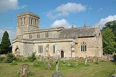 All Saints' parish church |
|
 Middleton Stoney |
|
| Area | 7.50 km2 (2.90 sq mi) |
|---|---|
| Population | 331 (2011 Census) |
| – density | 44/km2 (110/sq mi) |
| OS grid reference | SP5323 |
| Civil parish | Middleton Stoney |
| District | Cherwell |
| Shire county | Oxfordshire |
| Region | South East |
| Country | England |
| Sovereign state | United Kingdom |
| Post town | Bicester |
| Postcode district | OX25 |
| Dialling code | 01869 |
| Police | Thames Valley |
| Fire | Oxfordshire |
| Ambulance | South Central |
| EU Parliament | South East England |
| UK Parliament | Banbury |
| Website | Middleton Stoney Village Website |
|
|
Coordinates: 51°54′29″N 1°13′30″W / 51.908°N 1.225°W
Middleton Stoney is a village and civil parish about 2 1⁄2 miles (4 km) west of Bicester, Oxfordshire. The 2011 Census recorded the parish's population as 331.[1]
History
Aves ditch is pre-Saxon and may have been dug as a boundary ditch. It still forms the western boundary of the parish.
Middleton Stoney existed by the time of King Edward the Confessor, when one Turi held the manor.[2]
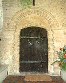
The earliest parts of the Church of England parish church of All Saints[3] are Norman, dating from the middle of the 12th century.[4] The bell tower has a ring of six bells, all cast in 1717 by Henry III Bagley of Chacombe.[2] Mears and Stainbank of the Whitechapel Bell Foundry recast the tenor and treble bells in 1883 and the fifth bell in 1885.[5]
All Saints' is now a member of the Church of England Benefice of Akeman, which includes the parishes of Bletchingdon, Chesterton, Hampton Gay, Kirtlington, Wendlebury and Weston-on-the-Green.[6]
Middleton Stoney had a motte-and-bailey castle, which was first recorded in 1215. Its remains are east of All Saints Church.[7]
The parish's common lands were enclosed at the end of the 17th century.[8] In 1824–25 George Child Villiers, 5th Earl of Jersey demolished the original village and manor house to make way for him to expand Middleton Park eastwards.[8] The castle mound and All Saints' church remain isolated within the extended park.[8] His wife Sarah Villiers, Countess of Jersey directed the building of new cottages on the edge of the park, each with a rustic porch and a flower garden.[8] These form the nucleus of the current village.[8]
The current village is at the crossroads of two main roads. The north-south road used to be the main road between Oxford and Brackley. In the 1920s it was classified as the A43. In the 1990s the M40 motorway was completed and the stretch of the A43 through Middleton Stoney was reclassified B430. The east-west road is the main road between Bicester and Enstone. In 1797 an Act of Parliament made this road into a turnpike.[2] It was disturnpiked in the 19th century and in the 20th it was classified B4030.
Middleton Park is a neo-Georgian country house built in 1938 by Edwin Lutyens and his son Robert for the 9th Earl of Jersey.[9]
Amenities
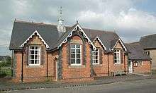
The village has one public house, the Jersey Arms,[10] and an Italian restaurant, the Rigoletto.[11] Middleton Stoney used to have a parish school; the building is now the village hall.
References
- ↑ "Area: Middleton Stoney (Parish): Key Figures for 2011 Census: Key Statistics". Neighbourhood Statistics. Office for National Statistics. Retrieved 29 October 2015.
- 1 2 3 Lobel 1959, pp. 243–251.
- ↑ "Middleton Stoney". Oxfordshire Churches & Chapels. Brian Curtis.
- ↑ Pevsner & Sherwood 1974, pp. 701–702.
- ↑ Davies, Peter (14 December 2006). "Middleton Stoney All Saints". Dove's Guide for Church Bell Ringers. Retrieved 19 December 2011.
- ↑ Archbishops' Council. "Benefice of Akeman". A Church Near You. Church of England. Retrieved 19 December 2011.
- ↑ Pevsner & Sherwood 1974, pp. 702–703.
- 1 2 3 4 5 Rowley 1978, p. 137.
- ↑ Pevsner & Sherwood 1974, p. 703.
- ↑ Best Western Jersey Arms Hotel
- ↑ Rigoletto Ristorante Italiano
Sources and further reading
- Blomfield, James Charles (1888). History of Middleton and Somerton. London.
- Lobel, Mary D, ed. (1959). A History of the County of Oxford, Volume 6. Victoria County History. pp. 243–251.
- Rahtz, Sebastian; Rowley, Trevor, eds. (1984). Middleton Stoney, Excavation and Survey in a North Oxfordshire Village 1970–1982. Oxford: Oxford University Department for External Studies. ISBN 0-903736-16-0.
- Rowley, Trevor (1978). Villages in the Landscape. Archaeology in the Field Series. London: J.M. Dent & Sons Ltd. p. 137. ISBN 0-460-04166-5.
- Sherwood, Jennifer; Pevsner, Nikolaus (1974). Oxfordshire. The Buildings of England. Harmondsworth: Penguin Books. pp. 701–704. ISBN 0-14-071045-0.
External links
| Wikimedia Commons has media related to Middleton Stoney. |
- Middleton Stoney Village Website
- Map sources for Middleton Stoney