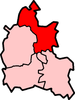
Upper Heyford, Oxfordshire
| Upper Heyford | |
 St Mary's parish church |
|
 Upper Heyford |
|
| Area | 6.59 km2 (2.54 sq mi) |
|---|---|
| Population | 1,295 (2011 census)[1] |
| – density | 197/km2 (510/sq mi) |
| OS grid reference | SP5026 |
| Civil parish | Upper Heyford |
| District | Cherwell |
| Shire county | Oxfordshire |
| Region | South East |
| Country | England |
| Sovereign state | United Kingdom |
| Post town | Bicester |
| Postcode district | OX25 |
| Dialling code | 01869 |
| Police | Thames Valley |
| Fire | Oxfordshire |
| Ambulance | South Central |
| EU Parliament | South East England |
| UK Parliament | Banbury |
| Website | Upper Heyford |
|
|
Coordinates: 51°55′48″N 1°16′26″W / 51.930°N 1.274°W
Upper Heyford is a village and civil parish about 6 miles (10 km) northwest of Bicester in Oxfordshire, England. The 2011 Census recorded the parish's population as 1,295.[2]
Geography
Upper Heyford is on the east bank of the River Cherwell. "Upper" distinguishes it from Lower Heyford which is about 1 mile (1.6 km) "lower", downstream along the Cherwell valley. Upper Heyford has access to the Oxford Canal from Allens Lane (at Allens Lock) which runs parallel to the River Cherwell. The canal flows from Banbury and Somerton to the north towards Lower Heyford and Oxford to the south.
Pre-history
The Portway is a pre-Roman road running parallel with the River Cherwell on high ground about 1 mile (1.6 km) east of the river. Its course bisects Upper Heyford parish and passes just east of the village. Part of it forms a minor road to Kirtlington.
Manor
The Domesday Book of 1086 records the village as Haiford, with a manor or 10 hides that was one of the many estates of the Norman baron Robert D'Oyly.[3] Along with many manors of the D'Oyly estate, Heyford became part of the Honour of Wallingford.[3] The manor was tenanted by the de Chesney family until the late 12th century, when Maud de Chesney became married to Henry FitzGerold, chamberlain to Henry II.[3] Maud left the manor to her eldest son Warin, who had succeeded to the manor by 1198 and after whom the village became called Heyford Warren.[3] Warin's daughter Margaret married Baldwin de Redvers, son of William de Redvers, 5th Earl of Devon.[3] Heyford Warren remained with the Earls of Devon and thereby passed to Isabella de Fortibus, Countess of Devon in 1262.[3]
Isabella outlived all her children, so after her death in 1293 her inheritance was disputed between Warin de Lisle and Hugh de Courtenay, who later became 9th Earl of Devon.[3] Warin died in 1296 but his son Robert eventually won seisin of Heyford Warren in 1310, except for two and a half virgates that were awarded to de Courtenay.[3] Robert also received the nearby manor of Fritwell from the Countess's estate. In 1380 his great-grandson, also Robert de Lisle, sold the manor along with some land at Barford St. Michael for £1,000 to William of Wykeham, Bishop of Winchester, who made them part of his endowment for the foundation of New College, Oxford.[3]
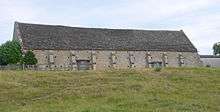
In about 1400[4] or shortly thereafter[3] New College had a tithe barn built at Manor Farm in the village. Its plan is 120 feet (37 m) by 24 feet (7.3 m),[3] it is of nine bays and built of coursed rubble with ashlar quoins and buttresses.[4] The roof is of Stonesfield slate and has raised-cruck trusses.[5] The building has similarities with tithe barns at Swalcliffe[5] and Adderbury,[3] both of which were also built for New College early in the 15th century. It is a scheduled monument[6] and a Grade I listed building.[5]
Upper Heyford's common lands were enclosed in 1842.[3] New College still held the manor in the early 1950s.[3]
Parish church
The village had a church by AD 1074.[3] The current Church of England parish church of Saint Mary may have been rebuilt in the latter part of the 15th century, but only the Perpendicular Gothic tower survives from that time.[3] Major repairs to the roof and south aisle were made in 1668 and 1769, but by the 1860s the nave and chancel were in a poor condition again.[3] The architect Thomas Talbot Bury, a pupil of A.W.N. Pugin, demolished all except the tower in 1865, and rebuilt them in a Gothic Revival interpretation of Perpendicular Gothic.[4] This Victorian building has extremely regular coursed masonry, which departs conspicuously from the traditional Medieval rubble masonry of the tower and, presumably, the previous church building. Bury preserved only a handful of features from the Medieval church: a Perpendicular Gothic window in the north wall of the chancel, a piscina, a tomb recess and a 13th-century effigy of a priest.[4]
The tower has three bells, the oldest of which is the tenor bell cast in 1624 by Richard I Purdue,[7] who had foundries in places including Glastonbury and Stoford in Somerset.[8] Mears & Stainbank of the Whitechapel Bell Foundry cast the second bell in 1866 and the treble bell in 1946.[7] St Mary's has also a Sanctus bell of unknown date.[7]
St Mary's parsonage was designed by William Wilkinson and built in 1869.[9]
St Mary's parish is now part of the Cherwell Valley Benefice, along with the parishes of Ardley, Fritwell, Lower Heyford, Somerton and Souldern.[10]
Economy and amenities


The village comprises just over 100 homes: a mixture of original 18th- and 19th-century Cotswold stone cottages, converted barns, stone-brick houses, 1950s and 1960s brick bungalows and rendered houses. The most recent houses have Cotswold stone exteriors which is more in keeping with the village's character.
The village green is overlooked by the former school, now a private house. The village has allotments, a sports field (home of Heyford United football team), village hall, children's playground and a public house: The Barley Mow.
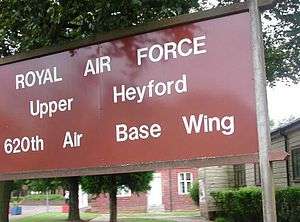
About 1 mile (1.6 km) east of the village is the former RAF Upper Heyford airfield. The RAF used the airfield from the 1920s as a bomber station, then in the 1950s assigned to the USAF. Since its closure in 1994, the airfield has become a substantial industrial and commercial estate. The runway, once the second longest in Europe, is used to store new cars awaiting delivery to dealers. Numerous Cold War relics remain including disused bunkers, water towers, huts and fences. There is a large number of former MoD houses immediately south of the airfield and industrial area which are rented.
There is a suggestion that Upper Heyford may be renamed "Heyford Warren" (the name for the village from about 200 years ago) with the Upper Heyford name being retained for the housing at the RAF station. It has been subject to much speculation regarding development for new housing. Several proposals (firstly for as many as 10,000 homes, then 1,000, then "several hundred") have been rejected. A further planning discussion is underway.
A planning application for RAF Upper Heyford was underway in 2007. The plan proposed the protection of most of the historic elements of the ex RAF station. However, most if not all of the bungalows south of the airfield would be demolished to make way for about 1,000 new houses.
In 2010 it was proposed that Houses south of Camp Road were to be retained and renovated and a new primary school built as well as new homes with some for social housing.
References
- ↑ Parish: Key Statistics: Population. (2011 census Retrieved 2016-05-04.
- ↑ "Area: Upper Heyford (Parish): Key Figures for 2011 Census: Key Statistics". Neighbourhood Statistics. Office for National Statistics. Retrieved 24 August 2015.
- 1 2 3 4 5 6 7 8 9 10 11 12 13 14 15 16 17 Lobel, 1959, pages 196–205
- 1 2 3 4 Sherwood & Pevsner 1974, p. 820.
- 1 2 3 "Tithe barn approximately 30 metres south of Manor Farmhouse". The National Heritage List for England. English Heritage. 26 February 1988. Retrieved 11 August 2011.
- ↑ Historic England. "Tithe Barn (1006351)". National Heritage List for England. Retrieved 25 August 2015.
- 1 2 3 Davies, Peter (15 December 2006). "Upper Heyford S Mary". Dove's Guide for Church Bell Ringers. Retrieved 9 August 2011.
- ↑ Dovemaster (25 June 2010). "Bell Founders". Dove's Guide for Church Bell Ringers. Retrieved 9 August 2011.
- ↑ Sherwood & Pevsner 1974, p. 821.
- ↑ Archbishops' Council. "Benefice of Cherwell Valley". A Church Near You. Church of England. Retrieved 24 August 2015.
- ↑ Crossley 1983, pp. 81–120.
Sources and further reading
- Blomfield, James Charles (1892). Part VI: History of Upper and Lower Heyford. Deanery of Bicester. London: Elliot Stock & Co.
- Crossley, Alan (ed.); Baggs, A.P.; Colvin, Christina; Colvin, H.M.; Cooper, Janet; Day, C.J.; Selwyn, Nesta; Tomkinson, A. (1983). A History of the County of Oxford. Victoria County History. 11: Wootton Hundred (northern part). London: Oxford University Press for the Institute of Historical Research. pp. 81–120. ISBN 978-0-19722-758-9.
- Lobel, Mary D, ed. (1959). A History of the County of Oxford. Victoria County History. 6: Ploughley Hundred. London: Oxford University Press for the Institute of Historical Research. pp. 196–205.
- Sherwood, Jennifer; Pevsner, Nikolaus (1974). Oxfordshire. The Buildings of England. Harmondsworth: Penguin Books. pp. 820–821. ISBN 0-14-071045-0.
- Wing, William (1865). Annals of Heyford Warren, otherwise Upper Heyford. Oxford.
External links
| Wikimedia Commons has media related to Upper Heyford, Oxfordshire. |