Cape Vincent, New York
| Cape Vincent | |
| Town | |
| Country | United States |
|---|---|
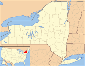
| State | New York |
| County | Jefferson |
| Coordinates | 44°07′40″N 76°20′00″W / 44.12778°N 76.33333°WCoordinates: 44°07′40″N 76°20′00″W / 44.12778°N 76.33333°W |
| Area | 89.9 sq mi (232.8 km2) |
| Population | 2,777 (2010) |
| Density | 30.9/sq mi (11.9/km2) |
| Town Supervisor | Debra Suller (R) |
| - Town Council | |
| Timezone | EST (UTC-5) |
| - summer (DST) | EDT (UTC-4) |
| ZIP code | 13618 |
| Area code | 315 |
 Location of Cape Vincent in New York
| |
Cape Vincent is a town in Jefferson County, New York, United States. The population was 2,777 at the 2010 census.[1]
The Town of Cape Vincent is located in the northwest part of the county. In the town is a village also called Cape Vincent. Both town and village are northwest of Watertown.
History
The town was first explored in the 17th Century by French explorers and missionaries. At that time it was home to the Onondaga tribe. Modern settlement began in 1801 at Millens Bay.
During the War of 1812, Cape Vincent was an armed camp to oppose the British forces in adjacent Kingston, Ontario.
The town was formed in 1849 from the north part of the Town of Lyme. In 1895, the community of Cape Vincent set itself apart by incorporating as a village. By that time, the region was becoming a famous tourist area due to the Thousand Islands.
In 1935, the East Charity Shoals Light was erected at the entrance to the Seaway.
The Xavier Chevalier House, Nicholas Cocaigne House, Remy Dezengremel House, Joseph Docteur House, James Buckley House, E. K. Burnham House, Reuter Dyer House, East Charity Shoal Light, Johnson House, Captain Louis Peugnet House, George Reynolds House, Rogers Brothers Farmstead, Tibbetts Point Light, Union Meeting House, Claude Vautrin House, and Warren Wilson House are listed on the National Register of Historic Places.[2]
Geography
According to the United States Census Bureau, the town has a total area of 89.9 square miles (233 km2).
The northwest border is the St. Lawrence River and the western border is Lake Ontario. Much of the town is a peninsula projecting into Lake Ontario, where the lake enters the river. The south part of the peninsula is in the neighboring Town of Lyme. The opposite shore of the river and some of the river islands are in Canada.
New York State Route 12E, an important highway, runs along the St. Lawrence River before it turns southeast at Cape Vincent village.
Demographics
| Historical population | |||
|---|---|---|---|
| Census | Pop. | %± | |
| 1850 | 3,044 | — | |
| 1860 | 3,585 | 17.8% | |
| 1870 | 3,342 | −6.8% | |
| 1880 | 3,143 | −6.0% | |
| 1890 | 3,014 | −4.1% | |
| 1900 | 2,882 | −4.4% | |
| 1910 | 2,575 | −10.7% | |
| 1920 | 2,111 | −18.0% | |
| 1930 | 1,958 | −7.2% | |
| 1940 | 1,954 | −0.2% | |
| 1950 | 1,842 | −5.7% | |
| 1960 | 1,756 | −4.7% | |
| 1970 | 1,748 | −0.5% | |
| 1980 | 1,823 | 4.3% | |
| 1990 | 2,768 | 51.8% | |
| 2000 | 3,345 | 20.8% | |
| 2010 | 2,777 | −17.0% | |
| Est. 2014 | 2,886 | [3] | 3.9% |
As of the census[5] of 2000, there were 3,345 people, 867 households, and 601 families residing in the town. The population density was 59.2 people per square mile (22.9/km²). There were 2,783 housing units at an average density of 49.3 per square mile (19.0/km²). The racial makeup of the town was 70.64% White, 21.88% African American, 0.39% Native American, 0.36% Asian, 6.28% from other races, and 0.45% from two or more races. Hispanic or Latino of any race were 13.27% of the population.
There were 867 households out of which 25.7% had children under the age of 18 living with them, 56.6% were married couples living together, 8.1% had a female householder with no husband present, and 30.6% were non-families. 27.0% of all households were made up of individuals and 13.5% had someone living alone who was 65 years of age or older. The average household size was 2.36 and the average family size was 2.83.
In the town the population was spread out with 13.2% under the age of 18, 8.7% from 18 to 24, 43.3% from 25 to 44, 22.4% from 45 to 64, and 12.4% who were 65 years of age or older. The median age was 38 years. For every 100 females there were 216.8 males. For every 100 females age 18 and over, there were 251.8 males.
The median income for a household in the town was $37,330, and the median income for a family was $43,558. Males had a median income of $42,361 versus $22,308 for females. The per capita income for the town was $16,375. About 8.5% of families and 12.3% of the population were below the poverty line, including 20.0% of those under age 18 and 11.1% of those age 65 or over.
Communities and locations in the Town of Cape Vincent
- Burnham Point State Park – A park on the St. Lawrence River across the channel from the eastern shores of Carlton Island.
- Carleton Island – An island in the St. Lawrence River opposite Burnham Point State Park. It was the site of the earliest settlement in Jefferson County, known as "King's Garden" where a fort was built in the late 17th century.
- Cedar Point State Park – A state park on the St. Lawrence River near the east town line.
- Cape Vincent – The Village of Cape Vincent is in the northwest part of the town on NY-12E. It had a railroad station from 1852 until the mid 20th century.
- Dablon Point – A headland on Lake Ontario between Mud Bay and Wilson Bay.
- Fox Island – An 263-acre (1.06 km2) island in Lake Ontario, southeast of Grenadier Island; once owned by former New York Governor Horace White; island auctioned off August 24, 2007 for $3.78 million to Vance Wilson, who claims he will keep the estate as it currently is.
- Fuller Bay – A bay of Lake Ontario at the west end of Cape Vincent peninsula.
- Grenadier Island – A large island in Lake Ontario west of Cape Vincent. It was an important military installation in the War of 1812.
- Kents Creek – A stream flowing southwest to enter Lake Ontario at Mud Bay.
- Millens Bay – A location northeast of Sunnybank on NY-12E.
- Mud Bay – A bay of Lake Ontario at the west end of Cape Vincent peninsula.
- Ponds Corners – A location at the junction of County Roads 8 and 56 in the southwest part of the town.
- Rosiere – A hamlet near the southeast town line on County Road 4. One of the former stations on the old Rome, Watertown and Ogdensburg Railroad.
- St. Lawrence – A hamlet near the east town line on County Road 4. It was originally called "St. Oars' Corners," "Gotham's Corners," and "Crane's Corners."
- Sunnybank – A hamlet located on the south bank of the St. Lawrence River, northeast of Cape Vincent village on NY-12E.
- Tibbets Point – A headland on Lake Ontario, north of Wilson Point. The lighthouse marking the entrance to the St. Lawrence Seaway is now a youth hostel operated by Hostelling International USA.[6]
- Warren Settlement-- A hamlet on County Road 4 near the town center. It was settled around 1825 by members of the Warren family.
- Wilson Bay – A bay of Lake Ontario at the west end of Cape Vincent peninsula.
- Wilson Point – A headland on Lake Ontario at the north headland of Wilson Bay.
References
- ↑ "American FactFinder". United States Census Bureau. Archived from the original on 2013-09-11. Retrieved 2011-05-14.
- ↑ National Park Service (2010-07-09). "National Register Information System". National Register of Historic Places. National Park Service.
- ↑ "Annual Estimates of the Resident Population for Incorporated Places: April 1, 2010 to July 1, 2014". Retrieved June 4, 2015.
- ↑ "Census of Population and Housing". Census.gov. Archived from the original on May 11, 2015. Retrieved June 4, 2015.
- ↑ "American FactFinder". United States Census Bureau. Archived from the original on 2013-09-11. Retrieved 2008-01-31.
- ↑ HI-Tibbetts Point Lighthouse 60050. HIUSA (2013-07-01). Retrieved on 2013-07-12.
External links
- Town of Cape Vincent - Official Website
- Village of Cape Vincent - Official Website
- Cape Vincent Village Information
- Cape Vincent Chamber of Commerce
- Early Cape Vincent history
- Fox Island auctioned off August 2007
Municipalities and communities of Jefferson County, New York, United States | ||
|---|---|---|
| City | 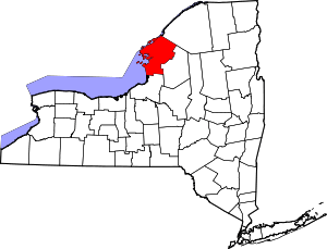 | |
| Towns | ||
| Villages | ||
| CDPs |
| |
| Hamlets | ||