Ijevan
| Ijevan Իջևան | ||
|---|---|---|
|
From top left: Ijevan skyline • Ijevan central park Ijevan Dendropark • World War II memorial Gugark mountains • Ijevan Wildlife Sanctuary Winter panorama of Ijevan area | ||
| ||
 Ijevan Իջևան | ||
| Coordinates: 40°52′45″N 45°08′50″E / 40.87917°N 45.14722°ECoordinates: 40°52′45″N 45°08′50″E / 40.87917°N 45.14722°E | ||
| Country |
| |
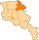
| Marz | Tavush | |
| Founded | 1780s | |
| City status | 1961 | |
| Area | ||
| • Total | 4.6 km2 (1.8 sq mi) | |
| Elevation | 755 m (2,477 ft) | |
| Population (2011 census) | ||
| • Total | 21,081 | |
| • Density | 4,600/km2 (12,000/sq mi) | |
| Time zone | AMT (UTC+4) | |
| Postal code | 4001, 4002 | |
| Area code(s) | (+375) 263 | |
| Vehicle registration | 57 | |
| Sources: Population[1] | ||


Ijevan (Armenian: Իջևան), is a town in Armenia and the administrative centre of the Tavush Province. It is located in the center of the region, at the foot of Ijevan and Nalteket ridges of Gugark mountains, on the shores of Aghstev River. As of the 2011 census, the population of the town is 21,081, making it the most populated town in the province.
Ijevan is located 137 km northeast of Yerevan.[2] The Yerevan-Tbilisi highway passes through Ijevan.
The town's current name Ijevan, and its former name Karavansara (until 1919), both mean "inn" (caravanserai), in Armenian and Persian, respectively.[3]
Etymology
The area of modern-day Ijevan used to have many roadside inns known as caravanserais that served travelers between historic Syria and North Caucasus. The settlement became to be known as Istibulagh, literally meaning hot spring in Azeri. On the same site, the small village of Karavansara was founded in the 1780s during the Persian rule. However, during the days of the First Republic of Armenia in 1919, the settlement was renamed Ijevan, meaning inn or caravanserai in the Armenian language.[4]։
History

It is said by tradition that about 2000 years ago, King Artavasdes I built a city on the place of modern-day Ijevan. He gathered only the beautiful girls and the handsome boys from all over Armenia, so that later they would get married and settle in the newly established town. Thus, the successors of that handsome generation live today in Ijevan.
Being located on a very important trade route between the Levant and Northern Caucasus, the region was home to many rest-houses and caravanserais for the merchants and their caravans. In the 1780s, during the Persian rule, the village of Karavansara was founded.[5] In 1801, the area of Ijevan along with Lori Province and the Georgian territories became part of the Russian Empire. During the rule of Paul I, approximately 6000 Armenian families from Karabakh were allowed to move to the valley of Aghstev river and occupy the region around Karavansara village.
In 1919, after the independence of Armenia, the name of the settlement of Karavansara was changed into Ijevan.
On 29 November 1920, Ijevan was the venue of the first Soviet rule in Armenia after being invaded by the Red Army from the north.
Chamber tombs near the city hospital and a late Bronze Age cemetery on the left bank of Aghstev attest to the early occupation of the site.[6] The remains of a medieval caravanserai could be found on the banks of Aghstev river on a site called Hamam-Jala.
Ijevan was granted the status of an urban community in 1970.
Geography

Surrounded with the Gugark mountains, Ijevan is situated in the valley of Aghstev river at an average height of 755 meters above sea level.[7] The surrounding mountains are covered with thick forests, turning into alpine meadows in some areas.
Ijevan is bordered by the village of Getahovit from the north and the village of Gandzakar from the south.
There is a small lake at the southern entrance of the town known as Spitak Jur.
Climate
This location is classified as Cfa by Köppen and Geiger.[8] The average temperature of the year is 10.6 C, in January 0 C, while in July 21.3 C. The maximum temperature registered ever in Ijevan is +37 C and the minimum is -23. The annual precipitation is 562 mm.
| Climate data for Ijevan, Armenia | |||||||||||||
|---|---|---|---|---|---|---|---|---|---|---|---|---|---|
| Month | Jan | Feb | Mar | Apr | May | Jun | Jul | Aug | Sep | Oct | Nov | Dec | Year |
| Average high °F (°C) | 40.8 (4.9) |
43.2 (6.2) |
52.5 (11.4) |
64.4 (18.0) |
73.8 (23.2) |
80.8 (27.1) |
86.9 (30.5) |
85.8 (29.9) |
78.3 (25.7) |
66.7 (19.3) |
54.3 (12.4) |
44.2 (6.8) |
64.31 (17.95) |
| Average low °F (°C) | 25.2 (−3.8) |
26.8 (−2.9) |
33.6 (0.9) |
42.8 (6.0) |
51.4 (10.8) |
57.9 (14.4) |
63.3 (17.4) |
62.8 (17.1) |
55.2 (12.9) |
45.7 (7.6) |
37 (2.8) |
29.1 (−1.6) |
44.23 (6.8) |
| Average precipitation inches (mm) | 0.67 (17) |
0.94 (24) |
1.3 (33) |
1.81 (46) |
2.83 (72) |
2.44 (62) |
1.42 (36) |
1.22 (31) |
1.1 (28) |
1.42 (36) |
1.06 (27) |
0.67 (17) |
16.88 (429) |
| Source: http://en.climate-data.org/location/2018/ | |||||||||||||
Demographics

Population
With a population of 20,223 (census2001), Ijevan is the largest urban community of Tavush. There has been no census since 2001. The population has declined considerably since 2001 due to high unemployment and subsequent emigration to Russian Federation.
| Year | 1831 | 1873 | 1897 | 1926 | 1939 | 1959 | 1976 | 1989 | 2001 |
|---|---|---|---|---|---|---|---|---|---|
| Population | 440 | 1,016 | 1,790 | 2,261 | 4,426 | 7,639 | 15,006 | 18,681 | 20,223 |
Religion
The majority of Ijevan are ethnic Armenians who belong to the Armenian Apostolic Church. The regulating body of the church is the Diocese of Tavush, headed by Archbishop Yeznik Petrosyan. The Surp Nerses Cathedral in Ijevan is the seat of the diocese.
Culture

Ijevan was used to host an annual symposium of sculpture between 1985 and 1990 with the presence of many experts from all over the world. Therefore, the residents of Ijevan started to call their town "the city of 100 sculptures". Currently, there are 116 sculptures erected at Ijevan sculptures garden at the centre of the town.
The ethnographic museum of Ijevan was reopened in 1999 while the art gallery was renovated in 2003.[9] The church of Surp Hovhannes is located in the southern part of the town. Another church in Ijevan has been built and financed by an Armenian benefactor from Boston.
Ijevan and the nearby countryside are home to several historic monuments of Armenian Architecture:
- Makaravank monastery of the 10th century located around 15 km north of Ijevan near the Achajur village. This purple and green stone complex in the forest above the village is a very popular destination.
- Arakelots Monastery of Kirants, dating back to the 13th century, located few kilometers north of Ijevan.
- Kirants Monastery of the 8th century 10 km north of Ijevan.
- Gandzakar village monastery few kilometers south of Ijevan.
Ijevan is a major centre for traditional Armenian handmade rugs and carpets.
The town has its local "Ijevan TV" station.[10]
Transportation

Ijevan is connected with the capital Yerevan and the rest of Armenian territories through the M-4 highway. The highway extends through the Armenia-Azerbaijan border at the northeast of the town.
Domestically, Ijevan is connected with other parts of Tavush through the H-35 Road.
The town used to have a railway station opened at the end of the 19th century. It was an important junction between Erivan and Elisabethpol within the Russian Empire. Nowadays, The station is closed with no rail service.
Economy
Industry

Ijevan is the economic centre of Tavush. During the Soviet period, the town had witnessed a remarkable industrial progress especially in the spheres of carpet manufacturing and wood processing. Many industrial plants of the Soviet days are still operating in Ijevan, including the "Ijevan Woodworking Enterprise" founded in 1936, the Ijevan Wine-Brandy Factory founded in 1951[11] (particularly famous for its pomegranate wine), the "Ijevan Mechanical Enterprise" founded in 1954, the "Ijevan Carpets" weaving mill founded in 1959, and the "Ijevan Bentonit Combine" for mining founded 1967. The Ijevan carpet weaving mill was the largest in the Caucasus and the 3rd-largest in the whole Soviet Union. The town is also famous for its handmade rugs and carpets. After the independence of Armenia, many small industrial plants were founded, including the "Karart" stone processing plant (since 2003).
In 2014, the "Vector" company for software development was opened in Ijevan.[12]
However, unemployment rates remain high in Ijevan and the entire region.
Tourism

Tavush is one of the most picturesque regions in Armenia. Nestled in the valley of Aghstev surrounded with forests and high mountains, Ijevan is more likely a forest-resort. The town did have a 200-bed high-rise hotel built in 1969 on the northern side of the main road which is now in ruins due to vandalism.
The Ijevan Sanctuary is a protected wildlife sanctuary at the west of the town, covering an area of 59 km².
The Yenokavan canyon near the village of Yenokavan village just to the north of Ijevan is among the most visited destinations in the region. It is characterized with beautiful cliffs, caves, forests, rivers and cascades. "Anapat cave" has pre-Christian carvings that resemble Mayan and Aztec works. There are small rest houses and a modern resort in the Yenokavan canyon.
Education

Ijevan is home to 6 public education schools and 3 kindergartens.
The Yerevan State University Ijevan Branch is operating since the 1994-1995 academic year. As of 2016, with more than 700 students, the Ijevan branch has 4 faculties:[13][14]
- Faculty of Natural Sciences:
- Programming and Information Technologies
- General Mathematics and Natural Science
- Faculty of Humanities:
- History and Social Science
- Pedagogy and Psychology
- Armenian Language and Literature
- Foreign Languages
- Faculty of Economics:
- General Economics
- Tourism Management and Culturology
- Faculty of Applied Arts:
- Drawing, Painting and Sculpture
- Decorative-Applied Art and Design
Sport

Ijevan is home to the all-seater Arnar Stadium, built in 2007 and hosted the Armenian Independence Cup final match in 2008 for the first and the only time being played outside the capital Yerevan.
FC Bentonit Ijevan was the only professional football club in the town, dissolved in 2007 due to financial difficulties.
International relations
Sister cities
-
 Valence, Drôme (France) since 1996.
See also
References
| Wikivoyage has a travel guide for Ijevan . |
| Wikimedia Commons has media related to Ijevan. |
- ↑ Tavush
- ↑ "Malcolm Simpson, Community-Based Economic Development Strategy, City of Ijevan, Armenia, 2003-2006" (PDF). 2002. Retrieved 2008-06-06.
- ↑ Kiesling, Rediscovering Armenia, p. 111, available online at the US embassy to Armenia's website
- ↑ Հ. Ղ. Գրգեարյան, Ն. Մ. Հարությունյան (1987). Աշխարհագրական անունների բառարան. Երևան: «Լույս».
- ↑ Lusamut
- ↑ "ArmeniaPedia.org, Ijevan Town". Retrieved 2009-01-04.
- ↑ Weather forecast for Ijevan in Tavush (Armenia), 755 m.
- ↑ http://en.climate-data.org/location/2018/. Missing or empty
|title=(help) - ↑ "Radio Liberty Armenia : Archives".
- ↑ "Albert Ghaltakchyan, 4th activity of the Technical Task (Agreement N C-3-020-3-F) of the "Rendering Service of Information Dissemination on Biodiversity Conservation and Protected Areas in the Gegharkunik and Tavush marzes of the Republic of Armenia"" (PDF). 16 April 2006. Retrieved 2008-06-06.
- ↑ Ijevan Wine-Brandy Factory
- ↑ New IT company opens in Armenian Ijevan
- ↑ YSU Ijevan branch
- ↑ "Yerevan State University : Structure". Retrieved 2008-06-06.