Kotayk Province
| Kotayk Կոտայք | ||
|---|---|---|
| Province | ||
| ||
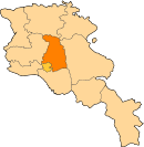
 Location of Kotayk within Armenia | ||
| Coordinates: 40°25′N 44°45′E / 40.417°N 44.750°ECoordinates: 40°25′N 44°45′E / 40.417°N 44.750°E | ||
| Country | Armenia | |
| Capital Largest city |
Hrazdan Abovyan | |
| Government | ||
| • Governor | Karapet Guloyan | |
| Area | ||
| • Total | 2,086 km2 (805 sq mi) | |
| Area rank | 8th | |
| Population (2011) | ||
| • Total | 254,397[1] | |
| • Rank | 4th | |
| Time zone | AMT (UTC+04) | |
| Postal code | 2201–2506 | |
| ISO 3166 code | AM.KT | |
| FIPS 10-4 | AM05 | |
| Website | Official website | |

Kotayk (Armenian: Կոտայք, Armenian pronunciation: [kɔˈtɑjkʰ]), is a province (marz) of Armenia. It is located at the central part of the country. Its capital is Hrazdan and the largest city is Abovyan. It is named after the Kotayk canton of the historic Ayrarat province of Ancient Armenia.
Kotayk is bordered by Lori Province from the north, Tavush Province from the northeast, Gegharkunik Province from the east, Aragatsotn Province from the west, and Ararat Province and the capital Yerevan from the south. Kotayk is the only province in Armenia that has no borders with foreign countries.
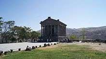
The province is home to many ancient landmarks and tourist attractions in Armenia including the 1st-century Temple of Garni, the medieval Bjni Fortress, 11th-century Kecharis Monastery and the 13th-century monastery of Geghard. Kotayk is also home to the popular winter sports resort and the spa-town of Tsaghkadzor and the mountain resort of Aghveran.
Etymology
| Part of a series on |
| Armenia Հայաստան |
|---|
  |
| Culture |
| History |
| Demographics |
| Administrative divisions |
|
| Armenia portal |
Kotayk Province is named after the historic Kotayk canton of the historic Ayrarat province of Ancient Armenia, directly ruled by the royal Arsacid dynasty.
Kotayk was first mentioned as an Armenian region by Ptolemy as Kotakene. According to Movses Khorenatsi, the name Kotayk is derived from an ancient nearby settlement called Kutis.
Geography

Situated at the central part of modern-day Armenia, Kotayk covers an area of 2,089 km2 (807 sq mi) (7% of total area of Armenia). It is bordered by Gegharkunik Province from the east, Tavush Province from the northeast, Lori Province from the north, Aragatsotn Province from the west, Ararat Province from the south and the capital Yerevan from the southwest.

Historically, the current territory of the province mainly occupies parts of the Aragatsotn, Kotayk, Varazhnunik and Mazaz cantons of Ayrarat province of Ancient Armenia.
Kotayk occupies the northeastern part of the Ararat plain. The Kotayk plain located between Hrazdan and Azat rivers has a height of 1,200–1,500 m (3,937–4,921 ft) above sea level. It is dominated by the Gegham mountains from the northeast including the mountains of Azhdahak, Hatis and Gutanasar. The province approximates the Pambak mountains at the north, while the Tsaghkunyats mountains lie at the west, and the Voghjaberd mountains at the southwest of Kotayk.
Affected by the Gegham volcanoes, the land relief of Kotayk is covered with lava and tufa.
Hrazdan, Getar and Azat are the 3 major rivers of the province. Lake Akna located at a height of 3,032 m (9,948 ft), is the only lake in the province.
The climate of the province is quite diversified. It ranges between arid and semi-arid climate at the south, and snowy climate at the centre and the north. Annual precipitation levels are less than 200 mm (7.9 in) at the dry areas, while it ranges between 400 and 900 mm (35.4 in) at the heights in the centre and the north of the province.
_%D5%AF%D5%A1%D5%B4%D5%A1%D6%80%D5%A7%D5%B6_%D5%BF%D5%A5%D5%BD%D5%A1%D6%80%D5%A1%D5%B6%D5%A8.jpg)
History

The earliest records about the region date back to the 1st and 2nd centuries AD. According to Ptolemy, Kotayk was directly ruled by the Arsacid kings of Armenia. However, during the 4th and the 5th centuries, the territories were granted to the Varazhnuni noble family who governed the forests and lands used as a hunting ground by the kings of the Arsacid kings. Later between the 5th and 7th centuries, the region was granted to the Kamsarakan and Amatuni families, under the Persian rule. Between the 7th and 9th centuries, Armenia suffered from the Arab Islamic occupation.
By the end of the 9th century, the region became part of the newly-established Bagratid Kingdom of Armenia. Between the 11th and 15th centuries, the region suffered from the Seljuk, Mongol, Ag Qoyunlu and Kara Koyunlu invasions, respectively.
At the beginning of the 16th century, the territory of modern-day Kotayk became part of the Erivan Beglarbegi within the Safavid Persia. During the first half of the 18th century, the territory became part of the Erivan Khanate under the rule of the Afsharid dynasty and later under the Qajar dynasty of Persia. It remained under the Persian rule until 1827-1828, when Eastern Armenia was ceded by the Russian Empire as a result of the Russo-Persian War of 1826–28 and the signing of the Treaty of Turkmenchay. With the fall of the Russian Empire and after the decisive Armenian victories over the Turks in the battles of Sardarabad, Abaran, and Gharakilisa, the region became part of the independent Armenia in May 1918.
After 2 years of brief independence, Armenia became part of the Soviet Union in December 1920. After the World War II, Kotayk witnessed major growth and development under the soviet rule. Many new urban settlements and industrial centres were established in the region, including the towns of Byureghavan (1945), Charentsavan (1947), Nor Hachn (1953), Hrazdan (1959) and Abovyan (1963). Thus Kotayk had gradually become a major industrial region within the Armenian SSR.
Between 1930 and 1995, modern-day Kotayk was divided into 3 raions: Kotayk raion, Nairi raion, and Hrazdan raion. With the territorial administration reform of 1995, the 3 raions were merged to form the Kotayk Province.
Demographics
Population
According to the 2011 official census, Kotayk has a population of 254,397 (123,524 men and 130,873 women), forming around 8.4% of the entire population of Armenia. The urban population is 137,481 (54%) and the rural is 116,916 (46%). The province has 7 urban and 60 rural communities. The largest urban community is the town of Abovyan, with a population of 43,495. The other urban centres are Hrazdan, Charentsavan, Yeghvard, Byureghavan, Nor Hachn, and Tsaghkadzor.
With a population of 7,198, the village of Jrvezh is the largest rural municipality of Kotayk.
Ethnic groups and religion

The majority of Kotayk Province are ethnic Armenians who belong to the Armenian Apostolic Church. The regulating body of the church is the Diocese of Kotayk, headed by Archbishop Arakel Karamyan. The Kecharis Monastery in Tsaghkadzor is the seat of the diocese.
However, small communities of Yazdis in Zovuni, Bjni, Getamej, and Dzoraghbyur.
Zovuni and Alapars have a significant number of Russian Molokans.
Hankavan has a majority of Greeks, while the village of Arzni is predominantly populated by Assyrians.
Minor communities of Russian Molokans, Yazidis, Kurds, Assyrians and Greeks are also found in Abovyan and Byureghavan.[2]
Culture
The Hrazdan Drama Theatre was founded in 1953. The Hrazdan branch of the National Gallery of Armenia and the Geological Museum of Hrazdan are also among the prominent cultural institutions in the province.
The urban centres of Kotayk have their own cultural centres and public libraries.
The House-museum of Brothers Orbeli in Tsaghkadzor, is dedicated to the Armenian scientists Ruben, Levon and Joseph Orbeli.[3]
The town of Yeghvard has a number of historic structures dating back to classical antiquity and the medieval period, including the "Seghanasar" ancient settlement from the 2nd millennium BC, the ruins of a 4th-century church surrounded with more than 30 khachkars dating back to the 12th century, the ruins of the 5th to 6th-centuries Katoghike Church, and the well-preserved Holy Mother of God Church of 1301.
Fortresses and archaeological sites
- Darani Cyclopean fortress, 2nd millennium BC,
- Seghanasar ancient settlement of Yeghvard, 2nd millennium BC,
- Jrvezh fortress, 2nd millennium BC,
- Garni Temple of the 1st century AD,
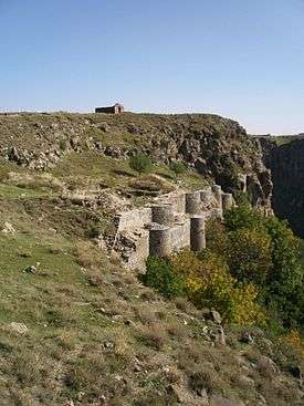
- Bjni Fortress of the 9th century,
- Astghaberd fortress of Hatis, medieval period
Churches and monasteries
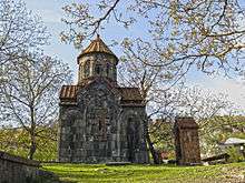
- Geghard monastery, founded in the 4th century,
- Surp Kiraki church in Arzni of the 6th century,
- Ptghnavank monastery, 6th to 7th centuries,
- Teghenyats Monastery, 6th to 7th centuries,
- Artavaz Monastery of the 7th century,
- Gharghavank monastery of the 7th century,
- Dzagavank Monastery of the 7th century,
- Mayravank Monastery of the 7th century,
- Neghuts Monastery of the 10th century,
- Makravank Monastery, 10th to 13th centuries,
- Holy Mother of God church in Bjni of 1031
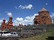
- Kecharis Monastery, 11th to 13th centuries,
- Havuts Tar monastery, 11th to 13th centuries,
- Mashtots Hayrapet Church of Garni of the 12th century,
- Tejharuyk Monastery of the Georgian Orthodox Church, opened in 1199,
- Yeghvard Church of 1301,
- Kaptavank Church of 1349,
- Holy Mother of God church in Arinj of the 15th century,
- Surp Hovhannes church of Abovyan opened in 2013.
Transportaion

The M-4 Motorway connects the province with the rest of Armenia. The local urban and rural settlements are connected to each other with a well-developed network of roads.
Economy
Agriculture
.jpg)
Kotayk is a major centre for agricultural products and cattle-breeding in Armenia, forming 6% of the annual total agricultural product of Armenia. Around 74% (1,546.4 km²) of the total area of the province are arable lands, out of which 24.4% (378 km²) are ploughed.[4] A total of 36,125 farms in Kotayk are operated by the private sector or through cooperatives.
The agricultural products of the province are divided as follows: 40% provided by cattle-breeding 40%, 14% by tobacco processing, 10% by fruits, 8% by vegetables, 28% by other products including grains and dry grains. The orchards mainly produce grapes, apricot, peach and apple.
Around 40% of the farmlands are irrigated, mainly through the Kanaker Hydroelectric Power Station canal and the Kotayk canal of Sevan–Hrazdan Cascade.
Kotayk has the 3 largest poultry farms in Armenia including the farms of Lusakert (in Nor Geghi), Arzni and Getamej.
Industry
Kotayk was a major industrial centre during the Soviet period. The towns of Byureghavan, Charentsavan, Nor Hachn, Hrazdan and Abovyan were founded by the USSR government between the 1940s and the 1960s to promote the industrial capacity of the Armenian SSR. However, many industrial plants have been revived after the independence of Armenia, mainly during the first decade of the 21st century. Currently, the province has a contribution of 13.5% in the annual total industrial product of Armenia. Food-processing, alcoholic beverages adn building materials production are the prevailing sectors in the industry of the province.
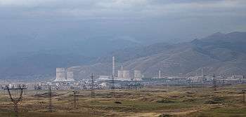
- Hrazdan is the most industrialized town of Kotayk. The Hrazdan Hydro Power Plant opened in 1959, the Hrazdan Thermal Power Plant opened in 1966, and the MIKA Cement factory opened in 1970, are among the largest plants in Armenia. The "Qualitech Machinery" machine tool-plant was founded in 1999. The town has also minor industrial firms including the "Hidro Storm" metal-plastic manufacturing plant founded in 2009, as well as the "Arjermek" and "Hakobyan" plants for building materials.
- Charentsavan is another major industrial centre in Kotayk. The town is home to many types of industries including the "Dzulakentron" metal casting plant founded in 1962, the "Charentsavan Precision Tool-Making Plant" founded in 1964,[5] the "Khorda Hydroturbines Manufacturing Enterprise" founded in 2006,[6] the "Bjni and Noy" mineral waters factory founded in 2010, the "Lubawa Armenia" safety equipments production founded in 2014.[7]
- Yeghvard has many major industrial plants including the Yeghvard wine-brandy factory founded in 1966, the "Nairishin" building materials plant founded in 1986, the Yeghvard sport shoes factory founded in 1987, the Yeghvard yeast plant founded in 1991, the Yeghvard Combined Feed Factory founded in 1993, the "Semur & Co" steel and metal manufacturing plant founded in 2003, and the "Shanazaryan" wine-brandy factory founded in 2005.[8] In 2016, the "Armoil" company for petroleum has built an oil refinery in Yeghvard.[9] The town is also home to the "65 Military Factory" specialized in military products.
- Byureghavan is major industrial centre since the Soviet period. The town's largest firms were opened during the Soviet days, including the "Arzni Group" mineral water plant founded in 1925 in Arzni and relocated to Byureghavan in 1974, the "Glass World" glass manufacturing enterprise founded in 1947, the "Almaqar" stone-processing enterprise founded in 1971, the "Sunenergashin" reinforced concrete columns manufacturers founded in 1973. During the 1990s, he "Byuregh Alco" wine-brandy-vodka factory (founded in 1996), and the "Varat" stone crushing plant (founded in 1997) were opened.
- Abovyan has an industrial district located to the south of the town. It is home to the "Suardi Armenia" factory for building materials (since 1963), the "Samkon" brandy factory (since 1970, privatized in 1998), the famous Kotayk Brewery founded in 1974, the "Poli-Serv" factory for polymer products (since 2001), the "Ginevan" factory for wine, brandy, beer and canned food (since 2011), and the "Italasphalt LLC" for asphalt and concrete production (since 2015). Other major firms include the "Tamara" factory for dairy products and sweets (since 1988), the "Luma" factory for meet products and chips (since 1995) , the "Armstone" plant for building materials (since 1996), the "Sipan" canned food and soft drinks plant (since 2003), and the "Tamara Food" for convenience food (since 2007).
- Nor Hachn is famous for its diamond cutting plants with many enterprises including: the "Shoghakn" plant founded in 1958, the "Andranik" plant founded in 1994, the "Arevakn" plant founded in 2000, and the "Agates" plant founded in 2001.
- Being located at the eastern suburbs of Yerevan, the village of Jrvezh is home to a large number of industrial firms including: the "Arega Cannery" (since 1995), the "Garni Crystalline" water manufacturers (since 1999), the Jrvezh Meat Factory (since 2006), and the "Javalex" factory for plastic products (since 2008).
- The village of Balahovit is also home to a number of industrial firms, including the "Argishty" mechanical enterprise (since 1989), the "Saranist" factory for glass containers (since 1989), and the "Filishin LLC" for concrete (since 2007).
Other major industrial firms located in the villages of Kotayk include: the "Chanakh" dairy factory founded in 1991 in Zovk, the "Glanzh Alco" wine, brandy and vodka factory founded in 2003 in Aramus, the "Nicola International Armenia" for canned food in Aramus (since 2003), the "Ptghni Gold" wine and liquor factory founded in 1996 in Ptghni, the "Bacon" factory for meet products founded in 1995 in Arzni, the "Multi Aquamarine" (since 2003) and "Pacific Home" (since 2014) for spring water production in Akunk, and the "Aquastone" spring water manufacturers in Bjni opened in 2012.
Tourism
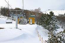
Tsaghkadzor spa town is a popular mountain resort in Kotayk with its several hotels and sanatoriums. The Tsaghkadzor ski resort is a major destination for the lovers of winter sports. Many 5-star luxury hotels and resorts serve the town during the summer and winter seasons including the Marriott Tsaghkadzor Hotel, Multi Rest House Hotel, Golden Palace Hotel and Ararat Resort Tsaghkadzor Hotel. The "Senator Royale" casino of Tsaghkadzor is among the largest entertainment centers in Armenia.
The villages of Hankavan, Pyunik, Agveran, Bjni and Arzni are popular summer resorts and major destinations for medical tourism.
The monastery of Geghard located at the south of province is a UNESCO World Heritage Site, designated as the Monastery of Geghard and the Upper Azat Valley. The pagan Temple of Garni and the medieval Kecharis Monastery are also among the attractive monuments of the province.
The province has 4 nature protected areas: the Erenbuni State Reserve, the Arzakan-Meghradzor Sanctuary, the Banks' Pine Grove Sanctuary, and the Hankavan Hydrological Sanctuary.
Kotayk has many spa and mountain resorts that attract tourists, including:
- Hankavan mountain resort,
- Aghveran mountain resort,
- Tsaghkadzor spa town,
- Tsaghkadzor ski resort.
Education
Hrazdan is home to the Humanitarian University of Hrazdan. Owned by the private sector, the university has 3 faculties: law, pedagogy and economics.
2 major science institutions and research centres are located in Abovyan: the Republican Hospital of tuberculosis and the Institute of Biological Microbes of the Armenian National Academy of Sciences.
The Armenak Khanperyants Military Aviation Institute is located near the town of Nor Hachn.
As of the 2015-16 educational year, Kotayk has 103 public schools as well as 1 private school. The number of state pre-school kindergartens is 54.[10][11]
Sport

Football, basketball and other Olympic sports including weightlifting and wrestling are popular in Kotayk.
FC Kotayk founded in 1955, is one of the oldest football clubs in Armenia. Like many other football teams in the country, the club was forced to default from the Armenian football league and consequently from professional football since 2005, due to financial crisis. The short-lived King Delux FC of Abovyan played a single season in the Armenian First League of 2012-13. Other defunct football teams of Kotayk include FC Moush Charentsavan, Hachn FC, FC Shinarar Hrazdan, FC Yeghvard, FC Dinamo Yeghvard and FC Moush Kasagh.
Abovyan City Stadium is the largest sport venue of the province. Minor stadiums are also located in Yeghvard, Hrazdan, Nor Hachn, Byureghavan, Charentsavan and Kasagh.
The town of Tsaghkadzor is a major centre for sports in general, mainly winter sports. It has a large sports complex as well as a ski resort.
The Zepyur Football Training Camp is located in the village of Pyunik at the north of Kotayk. The Dzoraghbyur Training Centre owned by FC Ararat Yerevan is also located in Kotayk, in the Dzoraghbyur village.
Communities
The province of Kotayk consists of the following 67 communities (hamaynkner), of which 7 are considered urban and 60 are considered rural.[12]
Towns or urban communities
| Image | City (town) | Province | Founded | Land area (km2) |
Population (2011 census) |
Population (2016 estimate) |
|---|---|---|---|---|---|---|
 | Abovyan | Kotayk | 1963 | 11 | 43,495 | 44,400 |
 | Byureghavan | Kotayk | 1945 | 4 | 9,513 | 9,300 |
 | Charentsavan | Kotayk | 1947 | 5 | 20,363 | 20,500 |
 | Hrazdan | Kotayk | 1959 | 22 | 41,875 | 41,200 |
 | Nor Hachn | Kotayk | 1953 | 2.3 | 9,307 | 9,400 |
 | Tsaghkadzor | Kotayk | 3rd century (first mentioned) |
4 | 1,256 | 1,200 |
 | Yeghvard | Kotayk | 6th century (first mentioned) |
7 | 11,672 | 11,900 |
Villages or rural communities
Non-community villages
- Aghveran, belongs to the Arzakan community.
- Gorgoch, belongs to the Meghradzor community.
- Pyunik, belongs to the Artavaz community.
Notable natives
- Grigor Magistros (990–1058), Armenian scholar and linguist.
- Leon Orbeli (1882–1958), Armenian physiologist.
- Arthur Gregorian, Armenian politician.
- Armen Nazaryan, Armenian judoka.
- Vanes Martirosyan, Armenian-American professional boxer.
- Masis Voskanyan, Armenian footballer.
Gallery
-

Arzakan-Meghradzor Sanctuary
-
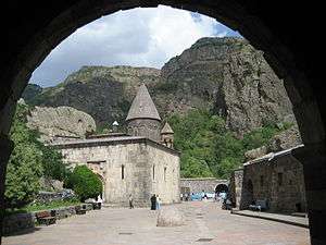
Geghard, 4th century, UNESCO World Heritage Site
-

The remains of Ptghnavank monastery, dating back to the 6th and 7th centuries
-

Kecharis Monastery in Tsaghkadzor, 11th century
-

The Azat Reservoir along the Azat River
See Also
References
- ↑ Kotayk population, 2011 census
- ↑ Byureghavan
- ↑ "Tsaghkadzor official web: Orbeli brothers' house-museum".
- ↑ Armstat: Kotayk Province
- ↑ About factory
- ↑ About Khorda
- ↑ Lubawa Armenia
- ↑ About Shahnazaryan factory
- ↑ Armoil factory in Yeghvard
- ↑ Kotayk Province schools
- ↑ Armstat: Kotayk Province
- ↑ "RA Kotayk Marz" (PDF). Marzes of the Republic of Armenia in Figures, 2002–2006. National Statistical Service of the Republic of Armenia. 2007.
External links
| Wikimedia Commons has media related to Kotayk Province. |
| Provinces (մարզեր) | ||
|---|---|---|
| City with special status |
| |
’