Aparan
| Aparan | ||
|---|---|---|
|
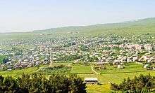
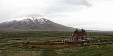
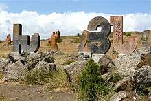
From top left: Aparan skyline with Mount Aragats to the right Battle of Abaran memorial • Mausoleum of General Dro Kasagh Basilica • Alphabet park and Mkhitar Gosh statue Aparan cross • Dusk over Aparan | ||
| ||
 Aparan | ||
| Coordinates: 40°35′20.81″N 44°21′25.97″E / 40.5891139°N 44.3572139°ECoordinates: 40°35′20.81″N 44°21′25.97″E / 40.5891139°N 44.3572139°E | ||
| Country |
| |
| Marz | Aragatsotn | |
| First mentioned | 2nd century | |
| Government | ||
| • Mayor | Gor Abrahamyan | |
| Area | ||
| • Total | 3.5 km2 (1.4 sq mi) | |
| Elevation | 1,880 m (6,170 ft) | |
| Population (2011 census) | ||
| • Total | 6,451 | |
| • Density | 1,800/km2 (4,800/sq mi) | |
| Time zone | GMT (UTC+4) | |
| Website | Official website | |
| Sources: Population[1] | ||


Aparan (Armenian: Ապարան), is a town in Armenia, located in the Aragatsotn Province, about 50 kilometers northwest of the capital Yerevan. As of the 2011 census, the population of the town is 6,451.
Etymology
It is commonly believed that the name of Aparan is derived from the Armenian word of Aparank; meaning a royal palace. However, throughout the history, the town was known with different names including Kasagh, Paraznavert, Abaran and Abaran Verin. Later, it was konwn as and Bash Aparan (Բաշ Ապարան) until 1935, when the name was finally changed to Aparan.
History
The first reference to the town of Aparan was made by Ptolemy during the 2nd century. Ptolemy referred to the settlement as Casala; the Hellenized version of the Armenian name of Kasagh. The town was the centre of Nig canton of the Ayrarat province of ancient Armenia. Kasagh was under the administration of the Gntunyan Armenian noble family.
Starting from the 10th century, the settlement of Kasagh was mentioned as Aparan. The new name was originated from the village of Aparank located in the Moxoene province of the Kingdom of Armenia, when some remains from the ancient Armenian monastery of Surp Khach of Aparan were transferred to the town of Kasagh. However, the 17th-century Armenian historian Zakarya of Kanaker, used to name of Kasagh to refer to Aparan. During the 18th century, the town was known as Bash-Aparan. The town remained under the name of Bash-Aparan until 1935, when it was officially changed into Aparan.
being one of the oldest surviving churches in the Armenian highland, the famous Kasagh Basilica of the Holy Sign of Cross was built by the end of the 4th century.[2] The church is undated and was partly restored in 1877.[2]
20th century and beyond
During the years of the Armenian Genocide, many Armenian refuge families arrived in Aparan from the Western Armenian cities of Van, Mush, Alashkert and Karin between 1914-1918. Many other families had also arrived from the Eastern Armenian town of Khoy.
The town was the site of the famous Battle of Abaran against the Turkish army on May 21, 1918 during the Caucasus Campaign of World War I, when the Turkish invasion of the newly independent Democratic Republic of Armenia was turned around. An impressive monument to the battle was erected in 1978 just north of the town.
Currently, Aparan has 3 public education schools and one musical school.
Aparan has to major industrial firms: the "Aparan Group" company for beverages, mineral water and dairy products, and the "Aparan Cheese Factory".
Geography and climate
Historically, Aparan is located in Nig canton of Ayrarat Province of the Kingdom of Armenia Mayor.
Modern-day Aparan is located at the eastern slopes of Mount Aragats and the norther slopes of Mount Ara, on the shores of Kasagh River, with an elevation of 1880 metres above sea level. The town is located 42 km north of Yerevan and 32 km north of the provincial capital Ashtarak, on Armenia's main north-south road.
Aparan has an Alpine climate in general with the influence of cold semi-arid climate. the town is characterized with snowy winters and mild humid summers. The average temperature is around -7°C in winter and 18°C in summer. The annual precipitation amount is between 450-600 millimeters.
Demographics
Many residents of Aparan are the descendents of Armenian migrants from the cities of Van, Mush, Alashkert and Karin, who arrived in the area escaping the massacres of the Armenians during World War I.
Currently the town has a predominantly Armenian population with a very small (~1%) minority of Pontic Greeks and Kurds.
Here is the population timeline of Aparan since 1831:
| Year | 1831 | 1873 | 1914 | 1931 | 1959 | 1979 | 2005 | 2011 |
|---|---|---|---|---|---|---|---|---|
| Population | 386 | 1,353 | 2,337 | 2,666 | 2,662 | 5,990 | 5,711 | 6,451 |
Culture
Aparan has many places of cultural interest including:
- Kasagh Basilica of the Holy Cross, built during the 4th century.
- Monument to the Battle of Abaran erected in 1978.
- Mausoleum of General Drastamat Kanayan near the battle memorial, reburied in Aparan on 28 May 2000.
- Aparan Alphabet park and the statue of the 12th-century Armenian scholar Mkhitar Gosh.
Transportation
Aparan is located on the M-3 Motorway that connects the Armenian capital Yerevan with the Georgian capital Tbilisi, passing through Aparan on the way to Lori Province.
Economy
Aparan used to be a major centre of carpet and textile production during the Soviet years. However, with collapse of the USSR the economy had drastically declined.
Currently, Aparan is home to the "Nig" factory for electrical products founded in 1964, the "Aparan Cheese Factory" founded in 1982 (privatized in 1995), and the "Aparan Group LLC" for bottled water, soft drinks and dairy products, founded in 2006, and the "Gntunik" plant for bakery and dairy products.
Sport
FC Nig Aparan represented the town in the domestic football completions after the independence of Armenia. However, like many other Armenian clubs, it was dissolved in 1999 due to financial difficulties. The town has a football stadium.
References
- ↑ Aragatsotn
- 1 2 Thierry, Jean-Michel (1989). Armenian Art. New York: Harry N. Abrams. p. 545. ISBN 0-8109-0625-2.
| Wikimedia Commons has media related to Aparan. |