Kajaran
- For the village just south of Kajaran, also called Kajaran, see Kajaran (village).
| Kajaran Քաջարան | ||
|---|---|---|
| community | ||
|
View of Kajaran | ||
| ||
 Kajaran | ||
| Coordinates: 39°09′04″N 46°09′36″E / 39.15111°N 46.16000°ECoordinates: 39°09′04″N 46°09′36″E / 39.15111°N 46.16000°E | ||
| Country |
| |
| Marz (Province) | Syunik | |
| City | 1958 | |
| Government | ||
| • Mayor | Vardan Gevorgyan | |
| Area | ||
| • Total | 2.8 km2 (1.1 sq mi) | |
| Elevation | 1,950 m (6,400 ft) | |
| Population (2011 census) | ||
| • Total | 7,163 | |
| • Density | 2,600/km2 (6,600/sq mi) | |
| Time zone | AMT (UTC+4) | |
| Website | Official website | |
| Sources: Population[1] | ||
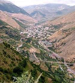

Kajaran (Armenian: Քաջարան [kʰɑdʒɑˈɾɑn]) is a town in the southern Syunik Province of Armenia. The name translates from Armenian as "the place of the brave". It is located 356 km away from Yerevan, 25 km away from Kapan, the regional center, and 50 km from the border of Armenia and Iran.
As of the 2011 census, the population of the town is 7,163.
History
The area of Kajaran has been occupied by dwellers since the 3rd-2nd millenaries B.C. The pagan temple found in the area testifies that. Metal was processed here since the Bronze Age.
The first copper mines of the area were built in 1850 and worked till 1910. After the discovery of huge copper deposits in 1930, the Soviet government proposed to build a copper-molybdenum plant which was put in service 1952, becoming one of the biggest enterprises of the USSR at that time. Thus, a town was built in the area of Verin Hand and Okhchi villages and its name was derived from the nearby village of Kajarants. The majority of the population of Kajaran were immigrants from Kapan and Karabakh.[2]
Nowadays, the town has 5 public education schools, 4 nursery schools, six libraries, a cultural centre, and a football stadium.
Geography
Kajaran occupies a part of Dzork county of the historic province of Syunik. The town is located on the border of two natural landscapes, alpine and highland forests and 1750-1800m above sea level, on the banks of river Voghji, between Zangezour and Meghri mountain ranges. The highest peak of Zangezour range, Mt. Kaputjugh (3905m) is located to the west of Kajaran. The relief is composed of plicate rock strata of river Araks basin and is characterized by active erosion.
Climate
Kajaran is located in an alpine climate zone. The average annual temperature is +6,9C, with the absolute maximum of +33,5C and the absolute minimum of -18.5C. Annual precipitation level is 600-705mm, mostly occurring in May-June, when it reaches 99-104mm, with maximum daily level of 66mm. The average humidity is 69% with May being the most humid month of the year (74%).
Mineral resources

Syunik is rich in mineral resources, including stone and ore resources. Armenia's biggest copper and molybdenum mine is located in Syunik. The mine was prospected in 1931, the exploitation started in 1952. The ore mainly contains molybdenite, chalcopyrite, magnetite and pyrite. It also contains valuable accompanying elements like gold, silver, rhenium, selenium and bismuth. Thick (up to 5m) quartz veins, containing significant amounts of molybdenum and copper are also quite common. The mine of Kajaran contains 87% of copper and 8% of molybdenum deposits of the region. The city is home to the Zangezur Copper and Molybdenum Combine.
Water resources
Kajaran belongs to the South Water Basin Management area. River Voghji (the length is 82 km, the catchment area is 1175sq.km) flows through the city; it starts from the confluence of Kajarants and Kaputjugh rivers, 6 km away from the Kajaran. Voghji is a typical mountain river with rugged stream bed and developed hydrographic network. It feeds both from thawing snow runoffs and groundwaters, with prevalence of one of its tributaries, Tzaghkari. It then flows into Arax river, at an altitude of 350m above sea level.
Land resources
The community is located at an altitude of up to 2100m above sea level. The soil is mostly gray and brown. Southern slopes are covered by typical alpine scrub grasslands with weak alpine turf soil. The total land area of the community is 1412ha, of which1342.59ha are owned by the community with the rest is public land.
Biodiversity
Kajaran is a part of Holarctis floristic province, Zangezur region, Voghji-Geghi area, characterised by prevalence of mesophytic, eurivalent and xerophytic plants. The area around the town is mostly covered by deciduous forests. The prevailing tree species are oak and hornbeam. Subalpine and alpine flora is represented by Gramieae, Poaceae Papilionacenae and Cyperaceae (feather-grass, brome-grass, cereals, sedge). The vegetation period is short. high humidity contributes to humus formation. Currently there are about 877 described plant species from 4 classes (Equisetophyta, Polipodiophyta, Pinophyta, Magnoliophyta), 57 families and 33 genera. The analysis of the local plant species confirmed that these include 4 Caucasian endemic and 2 Armenian endemic species. The habitats of the fauna in the area around the city include forests, sub-alpine and alpine zones with their characteristic flora. According to Dahl (1954) this area is a home to 2 described amphibia, 8 reptile, 52 bird and 16 mammal species. Deciduous forests are predominantly inhabited by small rodents; there are also bears, roes, wildcats, bats and other animals.
Demographics
According to 2001 census, the population of Kajaran was 8439. Men comprise 48%, women 52% of the population. According to the municipality data, the unemployment rate is 8.3%, of which 85% are women and 15% are men. There are 700 job seekers, which comprise 14% of the total labour force. The high level of female unemployment is due to the closure of weaving, relay and condenser manufacturing facilities, which used to employ the majority of women in the city.
Insufficient supply of housing in residential blocks forces the population to purchase apartments outside Kajaran, in the nearby communities. The influx of job seekers also creates pressure on the housing market. There are 120 people registered as job seekers in the need of housing.
Economy
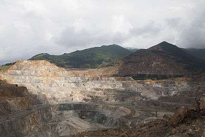
The key economic sector of the town is mining. Kajaran is home to the Zangezur Copper and Molybdenum Combine, operating since 1951. The plant initially used subsurface mining method; in 1959 it shifted to open-pit mining and used it in the central section of Kajaran moly-mine to extract ore and produce copper and molybdenite concentrates. The plant currently produces 10 million tons of concentrate annually. The copper concentrate is transported to Alaverdi metallurgical plant and Armenian Molybdenum Production company in Yerevan for further processing. Final treatment of molybdenite takes place at Yerevan Clear Iron Plant. The Copper-Molybdenum Plant employs 3800 people.
The labour market is rather lopsided. The industry sector employs 41% of the labor force. People from Kapan, Goris and Nagorno Karabagh come to Kajaran in search of employment. There are 1120 retired citizens in Kajaran. The average pension size is AMD 12000. 94 households are beneficiaries of the family benefit system. There are 216 registered people with disabilities, including 19 with service-incurred disabilities and 64 with congenital disabilities.
Notable natives
- Vahe Hakobyan (b. 1977), member of National Assembly of Armenia
References
| Wikimedia Commons has media related to Kajaran. |