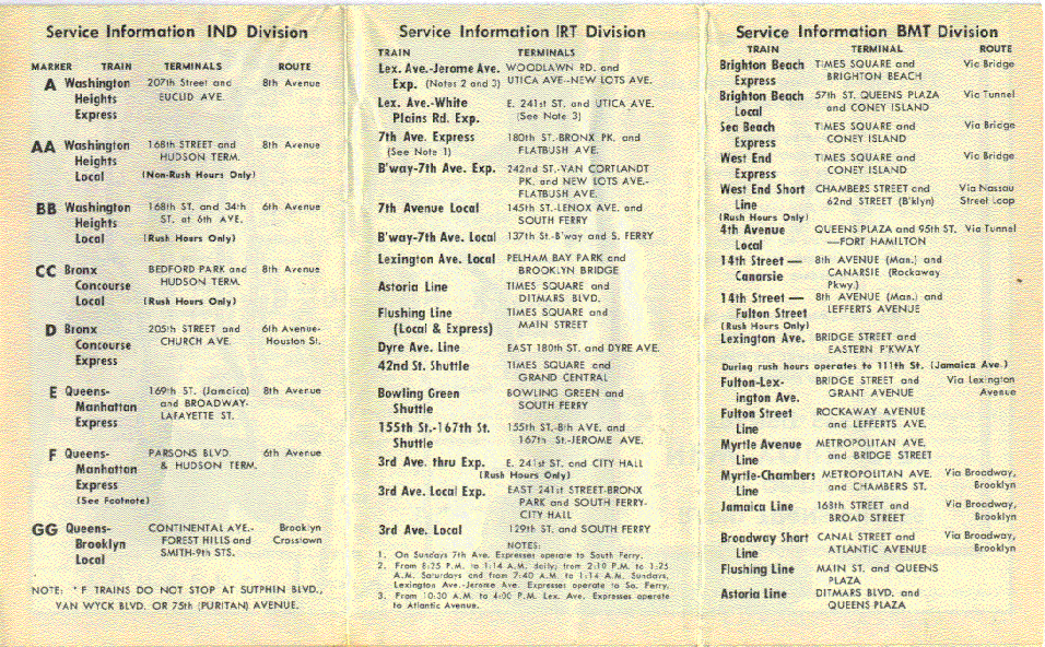
IRT Dyre Avenue Line
| IRT Dyre Avenue Line | |
|---|---|
|
The 5 train serves the entire IRT Dyre Avenue Line at all times. | |
| Overview | |
| Type | Rapid transit |
| System | New York City Subway |
| Termini |
North of Eastchester – Dyre Avenue Junction south of Morris Park |
| Stations | 5 |
| Daily ridership | 34,802[1] |
| Operation | |
| Opened | 1941 |
| Owner | City of New York |
| Operator(s) | New York City Transit Authority |
| Character | Elevated, open–cut, embankment, underground |
| Technical | |
| Number of tracks | 2–4 |
| Track gauge | 4 ft 8 1⁄2 in (1,435 mm) |
| Electrification | Direct Current traction |
IRT Dyre Avenue Line | ||||||||||||||||||||||||||||||||||||||||||||||||||||||||||||||||||||||||||||||||||||||||||||||||||||||||||||||||||||||||||||||||||||||||||||||||||
|---|---|---|---|---|---|---|---|---|---|---|---|---|---|---|---|---|---|---|---|---|---|---|---|---|---|---|---|---|---|---|---|---|---|---|---|---|---|---|---|---|---|---|---|---|---|---|---|---|---|---|---|---|---|---|---|---|---|---|---|---|---|---|---|---|---|---|---|---|---|---|---|---|---|---|---|---|---|---|---|---|---|---|---|---|---|---|---|---|---|---|---|---|---|---|---|---|---|---|---|---|---|---|---|---|---|---|---|---|---|---|---|---|---|---|---|---|---|---|---|---|---|---|---|---|---|---|---|---|---|---|---|---|---|---|---|---|---|---|---|---|---|---|---|---|---|---|
Legend | ||||||||||||||||||||||||||||||||||||||||||||||||||||||||||||||||||||||||||||||||||||||||||||||||||||||||||||||||||||||||||||||||||||||||||||||||||
| ||||||||||||||||||||||||||||||||||||||||||||||||||||||||||||||||||||||||||||||||||||||||||||||||||||||||||||||||||||||||||||||||||||||||||||||||||
The IRT Dyre Avenue Line is a New York City Subway rapid transit line, part of the A Division (IRT). It is a branch of the IRT White Plains Road Line in the northeastern section of the Bronx, north of East 180th Street. As of 2013 it has a daily ridership of 34,802.[1]
Extent and service
The following services use the Dyre Avenue Line:
| Time period | Services | |
|---|---|---|
| 5 | All times | Entire line |
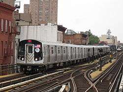
It is served by the 5 train, which makes all stops.[2]
The line is double-tracked for its entire length, with additional center tracks between Eastchester – Dyre Avenue and Baychester Avenue, and from Pelham Parkway to just south of Morris Park Avenue.
In the late 1990s the southbound express track was extended from south of Dyre Avenue and connected to the stub end track at Pelham Parkway for testing new subway cars for the A division. The southbound track at Dyre Avenue is in the position of the southbound express track, as the southbound local track is no longer present. The current platform is built over the northbound express track. Small portions of the original side platforms remain on both sides of Dyre Avenue station. South of Dyre Avenue station, the southbound track moves over to the local position and the southbound express track begins.
The northbound express track, now a stub end track at Pelham Parkway, has been used for storage but this use has largely been made redundant by the expansion of Unionport Yard. A small portion of this track also exists between Baychester and Dyre Avenue stations. The portion between Baychester and Dyre Avenue stations is currently in the process of demolition. The other portion has been extended to the northern end of Pelham Parkway in conjunction to the signal modernization project on the line.
The north end of the line is a simple two-track stub just below the Bronx County line, which is used to store trains,[3] with crossover tracks south of Dyre Avenue terminal. The south end is a flying junction (the Dyre Avenue Flyover), into the local tracks of the IRT White Plains Road Line (with crossovers to the express track).
Both of the inner tracks are currently in use for work trains involved in the signal modernization project on the line.
History
The Dyre Avenue Line was originally part of the four-track main line of the New York, Westchester and Boston Railway, an electrified commuter line that connected White Plains and Port Chester, New York to a station at the Harlem River adjacent to the IRT Third Avenue Line. The NYW&B opened on May 29, 1912. Soon a transfer station opened at East 180th Street, with transfers to the IRT White Plains Road Line and various surface lines. Express trains stopped within the Bronx only at Pelham Parkway and East 180th Street.[4] The NYW&B was abandoned on December 31, 1937 due to bankruptcy.[5]
Plans were made for a parallel subway line even before the NYW&B's abandonment; a 1929 expansion plan included a line along Morris Park Avenue, Wilson Avenue and Boston Road to Baychester Avenue, fed by the IND Second Avenue Line. When the IND Concourse Line was being built, the City, as part of the 1929 expansion plan, planned the line to be extended further east via Burke Avenue and Boston Road to Baychester Avenue.[6] However, due to the Great Depression, money for the line ran out, and as a result the integration of the NYW&B line was seen as a cheaper way to serve the Northeast Bronx.[7] In 1939, after abandonment, the plan was to integrate the former NYW&B to Dyre Avenue into the IRT system branching off the IRT Pelham Line as the Westchester and Boston Line. It was later decided to only utilize the line north of the East 180th Street station, even though the line continued to the Harlem River Terminal paralleling the New Haven Railroad right-of-way. However, a track connection to the New Haven Railroad was build in 1955 for equipment and material transfer.[8][9][10][11] The R17s were delivered via this connection in 1955,[12] and the R33/R36s were delivered via the connection in February 1964.[13]
The New York City Board of Transportation bought the NYW&B within the Bronx north of East 180th Street in April 1940 for $1,800,000 and rehabilitated the line.[14] The line was converted to accommodate IRT cars, and the 11,000 Volt AC power supply and the catenary were replaced by 600 Volt DC power supply via the third rails. Signals from the BMT Fulton Street Line also installed on the line. The Board of Transportation decided to rehabilitated twenty old surplus gate cars, numbered 1580–1587, 1589–1600, and 107, that were operating on the Third Avenue Elevated to use on the line.[7][15]
On March 19, 1941 a trailing point was built in from the existing White Plains Road Line to the former Track 3 of the NYW&B just north of the East 180th Street station, near the original IRT tower, and under the present Bronx River Parkway bridge. This granted access to the newly BOT-owned line for construction purposes, specifically re-electrification and signaling.[16]
The first train, an official train consisting of four cars with the Mayor and City officials, departed from East 180th Street at 11:21 AM on May 15, 1941. Trains on the line were shuttles, with a paper transfer to the IRT White Plains Road Line at East 180th Street.[7] When the city began operating the line it was considered as part of the IND Division internally, with IND crews operating the line because the city takeover of the IRT and BMT required that new lines be part of the IND.[14][17][18] However, to the riding public the line was advertised as an IRT line.[19] Shuttle trains consisting of two cars operated on the line and there was no late night service when the line opened in 1941. The fares were collected in the stations during rush hours, and by conductors on the trains when ridership was light.[7] The signs for stations on the Dyre Avenue Line used IND signs, with white letters on a green background. Plans for restoring the old line north into Westchester County failed.[20] For a few years, the line retained the 11,000 Volt catenary on the express tracks in case service to Westchester was resumed.[21] After the Dyre Avenue line was opened, using the outer tracks, tracks Y1 and Y2, and once it was certain that service to Westchester would not be revived the superfluous trackage from NYW&B days was removed, along with the catenary supports, for the World War II scrap drive of 1943.[16]
The connecting switch from the White Plains Road Line was not regularly used to bring in extra equipment or lay up a train on the Dyre Avenue Line itself until November 1952, and then only via new switches and the former Track 3, now Y1, at East 180th Street station. By this time some middle trackage had been restored as “Y3 and Y4” through Morris Park station and south of Dyre Avenue. The Y4 siding was later extended from Morris Park toward, but not to, Pelham Parkway by July 1971.[16]
On March 28, 1955, the NYCTA contracted with the New Haven Railroad (NHRR) for the installation of a non-electrified siding coming off NHRR track 1 below East 177th Street and using what would have been the alignment of NYW&B Track 2, track Y4. Third rail was installed north of East 177th Street, where the siding also swung over to the alignment of NYW&B track 4, track Y2 so as to line into the existing Y2 track at the local side of the station.[16]
In March 1954, the old gate cars were replaced by Hi-V cars. In October 1956 several Steinway cars were assigned to service on the line, and continued to serve the line until through service began.[7]
The Dyre Avenue Line was connected directly to the White Plains Road Line north of East 180th Street for $3 Million and through service began on May 6, 1957. The connection was originally supposed to open in 1950.[22] With the connection, the line became part of the IRT Division. Night service would continue to be operated by a shuttle. At this time, the old NYW&B station was closed and the trackage through the former station was made non-revenue, and it remains in part as a siding designated Track Y1A.[16][23] Through service was operated by Seventh Avenue express trains between 5:30 AM and 8:30 PM. Between 8:30 and 1:15 shuttle trains operated from East 180th Street to Dyre Avenue, and in the early morning hours no trains operated over the line.[15]
In the 1957 and 1960, on the grounds of the former Starlight Amusement Park grounds the former the last wooden MUDC cars and many Hi-V Steel subway cars were scrapped and burned. The tracks south of East 180th Street were used to hold the cars before the cars were disposed of.[24]
On February 27, 1962, the Transit Authority announced a $700,000 modernization plan of the Dyre Avenue Line, including the reconstruction of the Dyre Avenue station, and the extension of the platforms of the other four stations on the line.[25][26]
In 1963–1964, the Dyre Avenue terminal station was rebuilt. Previously, trains had used the northbound side platform as the terminal with the southbound platform unused. Remnants of the side platforms still exist.[27][28] The station was rebuilt with a single center island platform where the northbound express track was.[29]
On April 18, 1965, IRT Broadway – Seventh Avenue Line trains and IRT Lexington Avenue Line trains swapped their northern routings, with Broadway – Seventh Avenue 2 trains running via the IRT White Plains Road Line to 241st Street, and Lexington Avenue 5 trains running via the Dyre Avenue Line to Dyre Avenue.[30][31][32] The line is still operated as a shuttle late nights.[33]
The siding connection between the Dyre Avenue Line and Penn Central was discontinued on August 12, 1975, and the third rail was removed south of the station in 1979, where retired IRT subway cars were stored, and by 1979 the physical connection between the line and what was then Amtrak was permanently removed.[16]
In 2003–2004 the former NYW&B elevated structure was demolished south of Lebanon Street.[34][35] The former right-of-way was redeveloped with new buildings, and parking lots. Between 2006 and 2008, the earthen embankment from East 177th Street south to East 172nd Street at the Amtrak ROW was totally excavated and all that fill was removed to provide flat ground for redevelopment. The section between East 177th Street and East 174th Street was redeveloped into the Bronx Greenway–Starlight Park. A catenary signal gantry from the NYW&B was preserved and is located inside the park.[12][36]
Station listing

| Station service legend | |
|---|---|
| |
Stops all times |
| Time period details | |
| Neighborhood (approximate) |
Station | Tracks | Services | Opened | Notes | |
|---|---|---|---|---|---|---|
| Remainder of NYW&B in Westchester County abandoned | ||||||
| Eastchester | Eastchester–Dyre Avenue | 5 |
May 29, 1912 (NYW&B) May 15, 1941 (IRT) |
Originally a local station with two side platforms on the NYW&B. Converted to an island platform by the NYCTA. | ||
| Baychester | Baychester Avenue | local | 5 |
May 29, 1912 (NYW&B) May 15, 1941 (IRT) |
||
| Gun Hill Road | local | 5 |
May 29, 1912 (NYW&B) May 15, 1941 (IRT) |
|||
| Pelham Parkway | Pelham Parkway | all | 5 |
May 29, 1912 (NYW&B) May 15, 1941 (IRT) |
Bx12 Select Bus Service Was an express station on the NYW&B | |
| Morris Park | Morris Park | local | 5 |
May 29, 1912 (NYW&B) May 15, 1941 (IRT) |
||
| Connecting Track to Unionport Yard | ||||||
| Merges with IRT White Plains Road Line (5 | ||||||
| Remainder of NYW&B abandoned or demolished | ||||||
References
- 1 2 MTA. "Average weekday subway ridership". Retrieved 2 April 2014.
- ↑ "5 Subway Timetable, Effective November 7, 2016" (PDF). New York Metropolitan Transportation Authority. Retrieved November 7, 2016.
- ↑ "img356--NEG# 385 - N above Dyre AV STA by NB local Tk as layup-7-1964". Flickr. Retrieved 2016-08-31.
- ↑ "world.nycsubway.org: New York, Westchester, and Boston Railway". www.nycsubway.org. Retrieved 2016-08-31.
- ↑ "Westchester Line Passes with 1937". The New York Times. January 1, 1938. p. 36. Retrieved October 4, 2011.
- ↑ Raskin, Joseph B. (2015-01-20). The Routes Not Taken: A Trip Through New York City's Unbuilt Subway System. Oxford University Press. ISBN 9780823267408.
- 1 2 3 4 5 "Two Anniversaries–Dyre Avenue and Nassau Street". New York Division Bulletin. New York Division, Electric Railroaders' Association. 54 (5). May 2011. Retrieved August 31, 2016 – via Issu.
- ↑ Authority, New York City Transit (1955-01-01). Minutes and Proceedings.
- ↑ "Dyre Ave Line Memories". www.angelfire.com. Retrieved 2016-08-31.
- ↑ "www.nycsubway.org: Subway FAQ: Evidence of Former Lines and Connections". www.nycsubway.org. Retrieved 2016-08-31.
- ↑ "Dyre Ave Line Memories". www.angelfire.com. Retrieved 2016-08-31.
- 1 2 "NYW&B-IRT Line- E.174th St. JCT to E. 180th St Station & Yards". Flickr. Retrieved 2016-08-31.
- ↑ "NEW IRT R-33 Cars delivered in Feb. 1964 via ex-NYW&B RR tracks". Flickr. Retrieved 2016-08-31.
- 1 2 Cudahy, Brian J. (2009-08-25). A Century of Subways: Celebrating 100 Years of New York's Underground Railways. Fordham University Press. ISBN 9780823222957.
- 1 2 "Subway Trains Run to Dyre Avenue: Through Service Replacing Shuttle for Part of Each Day on Bronx Line". New York Times. May 7, 1957. Retrieved 20 December 2015.
- 1 2 3 4 5 6 "Map of the IRT Dyre Avenue Line". New York Division Bulletin. 30 (10). October 1987.
- ↑ Report including analysis of operations of the New York City transit system for five years, ended June 30, 1945. [New York,.
- ↑ "www.nycsubway.org: History of the Independent Subway". www.nycsubway.org. Retrieved 2016-08-31.
- ↑ "1958 Subway System Map Service Information". nycsubway.org. Hagstrom Company. 1948. Retrieved August 31, 2016.
- ↑ "Rail Line is Added to Subway System". The New York Times. May 16, 1941. p. 25. Retrieved October 4, 2011.
- ↑ "Dyre Ave Line Memories". www.angelfire.com. Retrieved 2016-08-31.
- ↑ Report for the three and one-half years ending June 30, 1949. [New York,.
- ↑ "IRT Spur Opens Today: Dyre Avenue Line in Bronx Will Have Five Stations". New York Times. May 6, 1957. Retrieved 20 December 2015.
- ↑ "Scrapping IRT EL & Subway cars along NYW&B at E.174th St Area". Flickr. Retrieved 2016-08-31.
- ↑ "IRT Improvements Set: $700,000 Contract Awarded for Work on Dyre Ave. Line". New York Times. February 28, 1962. Retrieved 20 December 2015.
- ↑ "NYW&B R'way-IRT Dyre Line - Morris Park to Dyre Ave.". Flickr. Retrieved 2016-08-31.
- ↑ "N on NB Local Track-Dyre STA to S. end old NB platform2008". Flickr. Retrieved 2016-08-31.
- ↑ Henderson, John (1992). Gotham Turnstiles: A Visual Depiction of Rapid Transit in the New York Metropolitan Area from 1958-1968. Flushing, New York: H&M Productions. ISBN 0-9629037-8-7.
- ↑ "N. at end of Dyre Line (ex-NYW&B RR) Track -6-1973". Flickr. Retrieved 2016-08-31.
- ↑ "New Routes Scheduled for 2 IRT Lines in Bronx". New York Times. March 22, 1965. Retrieved 20 December 2015.
- ↑ "Better Subway Service For Bronx IRT Riders Starting Sunday, April 18". Photobucket. New York City Transit Authority. April 1965. Retrieved 2016-08-31.
- ↑ "Better Subway Service For Bronx IRT Riders Starting Sunday, April 18". Photobucket. New York City Transit Authority. April 1965. Retrieved 2016-08-31.
- ↑ "5 Subway Timetable, Effective November 7, 2016" (PDF). New York Metropolitan Transportation Authority. Retrieved November 7, 2016.
- ↑ "NYW&B RR West Farms Trestle Demolition-2003". Flickr. Retrieved 2016-08-31.
- ↑ "Photos 1-50 of 52". www.nycsubway.org. Retrieved 2016-08-31.
- ↑ "S on former NYW&B R-o-W to Catenary-Signal Gantry above E.174 Roadway Bridge". Flickr. Retrieved 2016-08-31.
External links
| Wikimedia Commons has media related to IRT Dyre Avenue Line. |
- NYCsubway.org - IRT Dyre Avenue Line
- NYCsubway.org - New York, Westchester & Boston Railway
- New York, Westchester & Boston Railway
- Forgotten New York: New York, Westchester & Boston Railroad: Part 1, Part 2
- The Bronx Chronicle Dyre Avenue Projects
- Report to Committee on rehabilitation of the New York, Westchester and Boston railroad upon traffic, operation, earnings and capital costs, June 1940
| Services |
|      | ||||||
|---|---|---|---|---|---|---|---|---|
| Stations | ||||||||
| Divisions | ||||||||
| Other lists | ||||||||
| Expansion | ||||||||
| History | ||||||||
| Infrastructure | ||||||||
| Arts and culture | ||||||||
| Miscellaneous | ||||||||
| Other rapid transit in NYC | ||||||||