Williamsburg Bridge
| Williamsburg Bridge | |
|---|---|
 | |
| Coordinates | 40°42′47″N 73°58′12″W / 40.713°N 73.97°WCoordinates: 40°42′47″N 73°58′12″W / 40.713°N 73.97°W |
| Carries |
8 lanes of roadway, 2 tracks of the pedestrians, and bicycles |
| Crosses | East River |
| Locale | Manhattan and Brooklyn, in New York City |
| Maintained by | New York City Department of Transportation |
| Characteristics | |
| Design | Suspension bridge and truss causeways |
| Total length | 7,308 feet (2,227 m) |
| Width | 118 feet (36 m) |
| Longest span | 1,600 feet (490 m) |
| Clearance above | 10 feet 6 inches (3.2 m) (inner roadways only) |
| Clearance below | 135 feet (41 m) at mean high water |
| History | |
| Architect | Henry Hornbostel |
| Designer | Leffert L. Buck |
| Opened | December 19, 1903 |
| Statistics | |
| Daily traffic | 106,783 (2008)[1] |
| Toll | Free |
|
The bridge connects the Lower East Side neighborhood in Manhattan with the Williamsburg neighborhood in Brooklyn | |

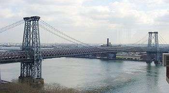
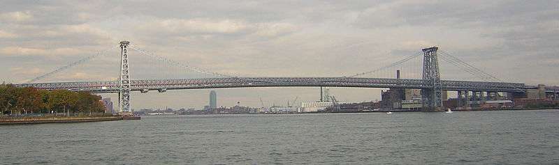
The Williamsburg Bridge is a suspension bridge in New York City across the East River connecting the Lower East Side of Manhattan at Delancey Street with the Williamsburg neighborhood of Brooklyn at Broadway near the Brooklyn-Queens Expressway (Interstate 278). It once carried New York State Route 27A and was planned to carry Interstate 78, though the planned I-78 designation was aborted by the cancellation of the Lower Manhattan Expressway and Bushwick Expressway.
This is one of four toll-free crossings between Manhattan and Long Island. The others are the Queensboro, Manhattan, and Brooklyn Bridges.
History

Construction on the bridge, the second to cross this river, began in 1896, with Leffert L. Buck as chief engineer, Henry Hornbostel as architect and Holton D. Robinson as assistant engineer, and the bridge opened on December 19, 1903 at a cost of $24,200,000.[2][3] At the time it was constructed, the Williamsburg Bridge set the record for the longest suspension bridge span on Earth. The record fell in 1924, when the Bear Mountain Bridge was completed.
Decades of deferred maintenance caused the bridge to deteriorate significantly; by 1988, more than 200 cables in the suspension had snapped, and pieces of concrete were falling from the bridge. The bridge's structural integrity was rated as 1.6 out of a scale of 1 to 7. Inspectors were appointed to monitor the bridge's status and make temporary bridge closures based on the amount of stress placed on the bridge.[4] The bridge was completely shut down to motor vehicle traffic and subway trains on April 11, 1988, after a painter noticed a large hole in a girder; upon further review, inspectors also discovered severe corrosion in a floor beam.[5] The bridge was reopened in June 1988.
The bridge was rebuilt through much of the 1990s and 2000s. The cast iron stairway on the Manhattan side, and the steep ramp from Driggs Avenue on the Williamsburg side to the footwalks, were replaced to allow handicapped access in the 1990s. Since the new bike path opened, the bridge has become the most heavily bicycled span in North America.[6] In 1999, Gandhi Engineering designed, engineered, and installed the pedestrian bridge along the Williamsburg Bridge.[7]
A celebration was held on June 22, 2003, to mark the 100th anniversary of the bridge and the area surrounding Continental Army Plaza was filled with musical performers, exhibits on the history of the bridge, and street vendors. Dignitaries marched across the bridge carrying the 45-star American flag used in a game of capture the flag played by workers after the placement of the final cable in June 1902. A truck-sized birthday cake was specially made for the event by Domino Sugar, which had a factory on the East River waterfront near the bridge.[8] The bridge was designated as a National Historic Civil Engineering Landmark by the American Society of Civil Engineers in 2009.[9]
Description
The Williamsburg Bridge has an unconventional structure among suspension bridges; though the main span hangs from cables in the usual manner, the side spans leading to the approaches are supported by trusswork, drawing no support from the cables above.[9] The main span of the bridge is 1,600 feet (490 m) long. The entire bridge is 7,308 feet (2,227 m) long, including approaches, and the deck is 118 feet (36 m) wide.[10] The height at the center of the bridge is 135 feet (41 m) and each tower is 310 feet (94 m),[11][12] measurements being taken from the river's surface at high-water mark.
The Brooklyn landing is between Grand Street and Broadway, which both had ferries at the time. The five ferry routes operated from these landings withered and went out of business by 1908.[13]
The bridge once carried New York State Route 27A. Had the Lower Manhattan Expressway been built, the Williamsburg Bridge would have been designated Interstate 78.
In reference to the area’s large Yiddish-speaking population, a sign on the westbound approach to the bridge reads, "Leaving Brooklyn: Oy Vey!"
Rail tracks
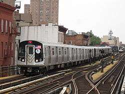
The Williamsburg and Manhattan bridges are the only suspension bridges in New York City that still carry both automobile and rail traffic. On the Williamsburg Bridge, there were once two sets of trolley tracks (four tracks in total), in addition to the two subway tracks currently on the bridge that connect the New York City Subway's BMT Nassau Street Line and BMT Jamaica Line.[14]


Two tracks on the south side carried streetcars from the Brooklyn side:[15]
- Williamsburg Bridge Local, 1904–1948
- Nostrand Avenue Line, 1904–1923 and 1931–1948[16]
- Ralph Avenue Line, 1905–1908; Ralph and Rockaway Avenues Line, 1908–1923 and 1931–1948[16]
- Tompkins Avenue Line, 1906–1923 and 1931–1947[16]
- Reid Avenue Line, 1904–1923[17][18] and 1931–1937[16]
- Broadway Line, 1904–1923[17][18]
- Franklin Avenue Line, 1904–1923
- Grand Street Line, 1904–1923
- Sumner Avenue Line, 1904–1923
- Wilson Avenue Line, 1904–1923
- Bushwick Avenue Line, 1904–1921
- Nostrand-Culver Line and Nostrand-Prospect Line, 1906–1919
Two north-side tracks carried Manhattan streetcars:
- Grand Street Line, 1904–1932
- Post Office Line, 1919-1932
- Seventh Avenue-Brooklyn Line, 1911-1919
- 8th Street Crosstown Line, 1904–1911
- 14th Street-Williamsburg Bridge Line, 1904–1911
- Fourth Avenue and Williamsburg Bridge Line, 1904–1911
The rapid transit tracks in the center of the bridge were initially used by the Brooklyn Rapid Transit Company (BRT) elevated railroad. Today, the New York City Subway's J M Z trains, successors to the BRT/BMT lines, use these tracks at the following times:
| Time period | |
|---|---|
| All times | |
| All times except late nights | |
| Rush hours in peak direction |
Plazas

At the foot of the bridge in Williamsburg between South 5th Place and Havemeyer Street in Brooklyn are three public areas that, collectively, comprise the Williamsburg Bridge Plaza, also known as Washington Plaza or George Washington Monument Park. It contains Continental Army Plaza and LaGuardia Playground, both operated by the Parks Department, as well as the Williamsburg Bridge Plaza Bus Terminal, which serves numerous bus lines to Brooklyn and Queens. The plaza is named after the large statue of George Washington in Continental Army Plaza erected in 1906.[19][20]
In popular culture
- The 1928 Edward Hopper painting "From Williamsburg Bridge" depicts a long-gone building as seen from the bridge's since remodeled walkway.[21]
- The Williamsburg Bridge appears in the films Fighting Death (1914); a lost film,[22] City for Conquest (1940), A Tree Grows in Brooklyn (1945), The Naked City (1948), The French Connection (1971), Serpico and Live and Let Die (both 1973), Once Upon a Time in America (1984), Johnny Suede (1991), Scent of a Woman (1992), American Gangster (2007), The Siege (1998), Léon (1994), The Naked Brothers Band: The Movie (2005), and The Dark Knight Rises and The Amazing Spider-Man (both 2012).
- The bridge is mentioned several times in the novel A Tree Grows in Brooklyn (1943) by Betty Smith. It is also referenced in the novels The Alienist (1994) by Caleb Carr and City of Bones, the first book of The Mortal Instruments. A scene in the book The Last Olympian takes place on the bridge.
- It is mentioned in several songs as well. East Bay rockers Black Cat Music have a song titled "Williamsburg Bridge Song". The song "True Dreams of Wichita", by Soul Coughing, includes the lyric "And you can stand on the arms of the Williamsburg Bridge crying 'Hey man, well this is Babylon'" The area by the bridge was the location for Depeche Mode's 1990 single "Policy Of Truth". It was also used as cover art for their following song "World In My Eyes". The Korean group BIGBANG filmed their "Bad Boy" music video on and around the bridge in 2012. Finally, Grammy-winning singer-songwriter Susan McKeown's 2012 album Belong opens with a duet with fellow Irish singer-songwriter Declan O'Rourke entitled "On The Bridge to Williamsburg".
- From 1959-61, during a sabbatical from performing, American jazz saxophonist Sonny Rollins would go to the Williamsburg Bridge for practice sessions in order to spare a neighboring expectant mother the noise. His 1962 album The Bridge, produced on his return from retirement, was titled after the bridge.[23]
- In 1996, artist Chris Doyle gilded the steps to the pedestrian walkway of the bridge. The project, known as "Commutable", was sponsored by the Public Art Fund, and transformed the decrepit and dangerous stairway into a monument to the thousands of everyday bicycle and walking commuters.[24][25]
- Aerialist Seanna Sharpe used the top of the bridge to stage an acrobatic performance on July 12, 2011.[26]
Gallery
 Fireworks on opening night, 1903
 The bridge under construction, seen from the Brooklyn side
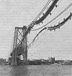 The bridge damaged by fire while under construction in 1902
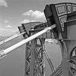 View of cables and saddle housing
 From South 6th Street on the Brooklyn side
 From Delancey Street on the Manhattan side
 J train on Williamsburg Bridge
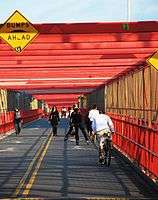 Runners and cyclists can avoid Brooklyn Bridge's tourist traffic
References
Notes
- ↑ "New York City Bridge Traffic Volumes 2008" (PDF). New York City Department of Transportation. March 2010. p. 63. Retrieved 2010-07-10.
- ↑ "Williamsburg Bridge". NYV Roads. Retrieved 2010-02-27.
- ↑ Staff (December 20, 1903). "New Bridge in a Glory of Fire; Wind-Up of Opening Ceremonies a Brilliant Scene". The New York Times. Retrieved 2010-02-27.
- ↑ "The Harder They Fall: Someone left the Williamsburgh Bridge out in the rain," New York Daily News Magazine, (April 10th, 1988) p.12
- ↑ Lyall, Sarah (April 13, 1988). "The Williamsburg Bridge Is Shut For 2 Weeks as Cracks Are Found". The New York Times. Retrieved 2010-02-27.
- ↑ "Williamsburg Bridge, New York, NY". Bikes Belong. Retrieved 11 April 2013.
- ↑ "Project Detail (221)".
- ↑ Mitchell, Ellen (June 19, 2003). "A 100-Year Span Gets Its Big Moment". Newsday.
- 1 2 "Williamsburg Bridge". ASCE Metropolitan Section. Retrieved 2016-11-12.
- ↑ "Williamsburg Bridge: Historic Overview" NYC Roads
- ↑ "Infrastructure: Williamsburg Bridge" New York City Department of Transportation website
- ↑ "Williamsburg Bridge". SkyscraperPage.
- ↑ Cudahy, Brian J. (1990). Over and Back: The History of Ferryboats in New York Harbor. New York: Fordam University Press. pp. 175–179. ISBN 0-8232-1245-9.
- ↑ Staff (December 19, 1903). "Construction of the Bridge". Brooklyn Daily Eagle. Retrieved 3 July 2015.
- ↑ Brennan, Joseph. "Williamsburg Bridge Railway Terminal". Retrieved 2010-02-27.
- 1 2 3 4 "Through Trolley Service on Bridge". Brooklyn Daily Eagle. February 15, 1931. p. 16. Retrieved 19 January 2016 – via Newspapers.com.
- 1 2 "Rush On New Bridge: Sunday Crowds Necessitated Extra Cars. Most Patrons Traveled to Brownsville". Brooklyn Daily Eagle. November 7, 1904. p. 2. Retrieved 19 January 2016.
- 1 2 "Through Service on Bridge to End". The New York Times. November 22, 1923. Retrieved 19 January 2016.
- ↑ "MTA Neighborhood Maps: Williamsburg & Bedford-Stuyvesant" (PDF). Metropolitan Transportation Authority. 2015. Retrieved 3 July 2015.
- ↑ Waite, Thomas L. (February 20, 1989). "About-Face for 'Valley Forge' Statue? Maybe.". The New York Times. Retrieved 3 July 2015.
- ↑ "Edward Hopper". National Gallery of Art. Retrieved 2010-02-27.
- ↑ 'Fighting Death' at the American Film Institute Catalog Retrieved February 24, 2016]
- ↑ Rollins, Sonny (April 23, 2015). "Sax and Sky". The New York Times Magazine. Retrieved 2015-05-27.
- ↑ Weber, Bruce (September 11, 1996) "Artist Transforms Bleak Bridge Walk Into Urban Dream" The New York Times
- ↑ "Commutable" on the Public Art Fund website
- ↑ Staff (July 12, 2001) "Daring Aerialist Seanna Sharpe Arrested After Scaling, Performing On Williamsburg Bridge" CBS New York
Further reading
- Barbas, Jamey A. (October 2000). "Saving the Williamsburg Bridge". Civil Engineering: 64–67.
- Bruschi, Maria Gracia (March 1996). "Preserving Williamsburg's Cables". Civil Engineering: 36–39.
- Mondello, Frank J. (January 1989). "Inspecting and Evaluating New York's East River Suspension Bridge Cables". Public Works.
External links
| Wikimedia Commons has media related to Williamsburg Bridge. |
- Preliminary proposal for a new Williamsburg Bridge by Pei Cobb Freed & Partners
- Williamsburg Bridge info from NYCDOT
- Williamsburg Bridge at Structurae
- Historic American Engineering Record (HAER) No. NY-128, "Williamsburg Bridge"
- nycroads.com Williamsburg page. Has excellent construction photos (taken from Parsons Transportation Group (parsons.com site), the successor company to the design firm that executed the original design) as well as replacement bridge proposal details.
- NYCsubway.org - Williamsburg Bridge
- Williamsburg Bridge photographs from the pedestrian walkway by Lindsay Blair Brown
- NYCDOT Bicycle counts on Williamsburg Bridge and other major bike routes
| ||||||||||||||||||||||||||||||||||||||||||||||||||||||||||||