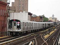
IRT Pelham Line

The IRT Pelham Line, also called the Southern Boulevard–Pelham Bay Park Line,[2] is a rapid transit line on the New York City Subway, served by the 6 and <6> trains.[3] It was built as part of the Dual Contracts expansion and opened in 1918. It is both elevated and underground with Whitlock Avenue being the southernmost elevated station. It has three tracks from the beginning to just south of the Pelham Bay Park terminal. The Pelham Line also has a connection to Westchester Yard, where 6 trains are stored, just north of Westchester Square–East Tremont Avenue. As of 2013, it has a daily ridership of 205,590.
History
The construction of the Pelham Line was part of the Dual Contracts, signed on March 19, 1913 and also known as the Dual Subway System.[4] The Pelham Line was proposed to be a branch of the Lexington Avenue Line running northeast via 138th Street, Southern Boulevard and Westchester Avenue to Pelham Bay Park.[5]
A report, "Proposed Subway Plan for Subway Relief and Expansion" by Major Philip Mathews, published on December 24, 1926, proposed a connection from the Pelham Line to a newly proposed four-track Third Avenue subway that would run to City Hall and Downtown Brooklyn.[6]
On August 1, 1918, a branch of the IRT Lexington Avenue Line, the IRT Pelham Line was opened to Third Avenue–138th Street.[7] On January 17, 1919, the Pelham Line was extended to Hunts Point Avenue. The extension was originally supposed to be finished by the end of 1918, but due to the difficulty in acquiring materials, the opening was delayed. In January 1919, the Public Service Commission was acquiring property for a subway yard at Pelham Bay Park.[2] On May 27, 1920, the Pelham Line was extended to East 177th Street.[8] By October 24 of the same year, it was extended to Westchester Square, and by December 20, it was extended to the western edge of Pelham Bay Park.
When the New York, Westchester and Boston Railway was abandoned in 1937, one proposal for the replacement IRT Dyre Avenue Line was to connect the line to the IRT Pelham Line at Whitlock Avenue, rather than its current terminus at East 180th Street on the IRT White Plains Road Line.[6]
Improvements
On June 6, 1946, the Board of Transportation announced that a contract for the instillation of signal equipment that would allow express service to run on the Pelham Line was jointly awarded to the Emerson–Garden Electric Company and L. K. Comstock & Company Incorporated for $129,516. The signals were to be installed between Third Avenue–138th Street and Parkchester.[9]
Beginning October 14, 1946, weekday rush and Saturday morning rush peak direction express service started, with Pelham Bay trains using the middle track between East 177th Street and Third Avenue – 138th Street.[10] This express service saved eight minutes between Third Avenue and East 177th Street. During this time, 6 trains that ran local in the Bronx when express trains operated began to terminate at East 177 Street to make room for express trains to Pelham Bay Park.[11] Express service did not start until this date because of the increase in ridership from the huge Parkchester housing complex at East 177th Street.[12]
On November 8, 1947, Union Switch and Signal Company was awarded a contract for $819,375 for block signaling on the Pelham Line. This would have allowed an extension of express service from Parkchester to Pelham Bay Park.[13]
The Westchester Yard was expanded between 1946 and 1949 and the scope of the project included a new signal tower, signal installations, and the elimination of the grade crossings between the yard and the Pelham Line north of the Westchester Square station. All of these projects would allow for sped up main line service and train movements in and out of the yard. The grade separation allowed trains to enter Westchester Yard without crossing the express track or the downtown local track and it allowed for the possibility of the extension of express service to Pelham Bay Park, which would save four more minutes.[12] The increased capacity of the yard allowed the yard to store 358 additional subway cars. With the additional storage space, it would no longer be required to lay up trains on the middle track of the line between East 177th Street and Pelham Bay Park, and it would allow for full day express service. The construction of substations would improve voltage conditions and allow for longer trains to be operated on the line. The work was projected to cost $6,387,000 and it was projected to be completed in 1950.[11]
On August 27, 1953, the New York City Transit Authority approved a plan to lengthen trains along the Pelham Line from seven cars to eight cars during rush hours. The change took place on September 8, 1953.[14]
Unrealized expansion plans
As part of a 1951 plan, the capacity on the Pelham Line would have been increased.[15]
In March 1954, as part of a proposed $658,000,000 construction program, the Pelham Line would have been connected to the Second Avenue Subway, with service being tripled on the Pelham Line.[16]
The IRT Pelham Line would be converted to B Division standards and connected to the Second Avenue line as Route 132–B of the 1968 Plan for Action. IND Second Avenue Line trains would run east under 138th Street, then along the right-of-way of Amtrak's Northeast Corridor from 138th Street to a point near the Bruckner Expressway and Westchester Avenue as an express bypass of the Pelham line, after which the line would split into a Pelham branch and a Dyre Avenue branch.[17]
The Brook Avenue station just east of Third Avenue–138th Street on the IRT Pelham Line would be reconstructed to allow a cross-platform interchange.[17][18][19] Further north, there would be a connection with the IRT Pelham Line near Westchester Avenue at the Whitlock Avenue station, and station platforms north to Pelham Bay Park would be narrowed and lengthened to accommodate the longer and wider B Division trains from the Second Avenue Subway. IRT local service on the Pelham Line would terminate at Hunts Point Avenue one stop south.[17][18][19] This project would have helped relieve overcrowding on the IRT Lexington Avenue Line, which is the busiest line in the country.[20]
Under Phase 2 of the Plan for Action, the Pelham Line would have been extended to a modern terminal in the Co-op City housing complex.[18][19]
Due to the 1975–76 fiscal crisis that affected the city, most of the remaining projects did not have funding, so they were declined. Expected to be completed by the mid-1970s and early 1980s,[21][22] lines for the Program for Action had to be reduced or canceled altogether due to the 1970s fiscal crisis.[23]
Extent and service
| Service | Time period | Between | |
|---|---|---|---|
| Third Ave–138 St Parkchester |
Parkchester Pelham Bay Pk | ||
| Rush hours and middays |
local | no service | |
| Other times | local | ||
| Rush hours and middays |
express | local | |
| Other times | no service | ||
Express service operates between Parkchester and Third Avenue–138th Street during weekdays from approximately 6:30 a.m. to 8:45 p.m. At those times, Pelham Bay Park cannot handle the large number of 6 and <6> trains in service. As a result, 6 trains run local on the Pelham Line south of Parkchester and short turn there. <6> trains make all stops north of Parkchester, then run express using the center track between that station and Third Avenue–138th Street in the peak direction. At all other times, 6 trains run local on the entire line.[3]
Route description
Beginning at a junction with the IRT Jerome Avenue Line north of the Lexington Avenue Tunnel at 135th Street,[2] the IRT Pelham Line runs beneath 138th Street for the first three stations in Mott Haven, then curves to the northeast along eastbound Bruckner Boulevard before shortly curving north again along Southern Boulevard. After 145th Street at Samuel Gompers High School, the line curves to the northeast continuing to run under Southern Boulevard. The line returns under eastbound Bruckner Boulevard again, only to leave at Whitlock Avenue and begins to emerge from underground at Aldus Street. The line is transformed into an elevated line over Whitlock Avenue at East 165th Street, but shortly after this encounters the Whitlock Avenue Subway station and curves east over Westchester Avenue which runs over the Sheridan Expressway, Harlem River and Port Chester Railroad line, and the Bronx River. The line remains over Westchester Avenue throughout the rest of its journey.
East of Morrison Avenue station, the road runs over the Bronx River Parkway, and enters Parkchester. The station named after the neighborhood runs over the Hugh J. Grant Circle, which is also over the Cross Bronx Expressway. East of Castle Hill Avenue station, Westchester Avenue branches off to the northeast at Waterbury Avenue (which runs in the same direction prior to that branching), and the line follows. After the Westchester Yard the line runs over the Hutchinson River Parkway interchange just west of Middletown Road station. The line finally ends at Pelham Bay Park station, which contains a pedestrian bridge across Bruckner Expressway leading to the eponymous park.
Depiction in fiction
The train that is hijacked in the book The Taking of Pelham One Two Three by Morton Freedgood (writing as John Godey) and the three films based on the novel originated on this line from Pelham Bay Park at 1:23 (hence the name "Pelham 123"). It was subsequently hijacked on the IRT Lexington Avenue Line.
Station listing
| Station service legend | |
|---|---|
| |
Stops all times |
| |
Stops all times except rush hours in the peak direction |
| |
Stops rush hours in the peak direction only |
| Time period details | |
| Neighborhood (approximate) |
Station | Tracks | Services | Opened | Notes | |
|---|---|---|---|---|---|---|
| Pelham Bay | Pelham Bay Park | 6 |
December 20, 1920 | Bx12 Select Bus Service Elevators are temporarily out of service for repairs until March 2016.[24] | ||
| Center Express track begins (No Regular Service to Parkchester) | ||||||
| Buhre Avenue | local | 6 |
December 20, 1920 | |||
| Middletown Road | local | 6 |
December 20, 1920 | |||
| connecting tracks to Westchester Yard | ||||||
| Westchester Square | Westchester Square–East Tremont Avenue | local | 6 |
October 24, 1920 | ||
| Castle Hill | Zerega Avenue | local | 6 |
October 24, 1920 | ||
| Castle Hill Avenue | local | 6 |
October 24, 1920 | |||
| <6> | ||||||
| Parkchester | Parkchester | all | 6 |
May 27, 1920 | Q44 Select Bus Service originally Parkchester–East 177th Street | |
| Soundview | St. Lawrence Avenue | local | 6 |
May 27, 1920 | ||
| Morrison Avenue–Soundview | local | 6 |
May 27, 1920 | originally Sound View Avenue, Morrison–Sound View Avenues | ||
| Elder Avenue | local | 6 |
May 27, 1920 | |||
| Longwood | Whitlock Avenue | local | 6 |
May 27, 1920 | ||
| Hunts Point Avenue | all | 6 |
January 7, 1919 | |||
| Longwood Avenue | local | 6 |
January 7, 1919 | |||
| East 149th Street | local | 6 |
January 7, 1919 | |||
| Mott Haven | East 143rd Street–St. Mary's Street | local | 6 |
January 7, 1919 | ||
| Cypress Avenue | local | 6 |
January 7, 1919 | |||
| Brook Avenue | local | 6 |
January 7, 1919 | |||
| Third Avenue–138th Street | all | 6 |
August 1, 1918 | |||
| Center Express track ends | ||||||
| Merges with IRT Lexington Avenue Line (6 | ||||||
References
- ↑ MTA. "Average weekday subway ridership". Archived from the original on March 28, 2014. Retrieved 2 April 2014.
- 1 2 3 "New Lines In Bronx Coming This Year: Rays of Rapid Transit to be Let Into Dark Sections in the West and North". nytimes.com. The New York Times. January 7, 1919. Retrieved 25 January 2016.
- 1 2 "6 Subway Timetable, Effective November 7, 2016" (PDF). New York Metropolitan Transportation Authority. Retrieved November 7, 2016.
- ↑ nycsubway.org—The Dual Contracts
- ↑ "The Dual System of Rapid Transit (1912)". www.nycsubway.org. Retrieved March 25, 2014.
- 1 2 nycsubway.org—History of the Independent Subway
- ↑ "Opening New Subway H Shortens Distance to A. & S.". Brooklyn Daily Eagle. August 1, 1918. p. 8. Retrieved January 25, 2016.
- ↑ "Bronx Subway Extension Opened". New York Times. May 28, 1920. Retrieved 25 January 2016.
- ↑ "Awards Subway Contract". New York Times. June 7, 1946. Retrieved January 25, 2016.
- ↑ Bolden, Eric. "NYCT Line by Line History". www.erictb.info. Retrieved 2016-09-01.
- 1 2 Report for the three and one-half years ending June 30, 1949. New York City Board of Transportation. 1949.
- 1 2 Null(0), Tramway (2014-10-08). "Streetcars and Spatial Analysis: Pelham Subway Line: Track Plan as of 1988". Streetcars and Spatial Analysis. Retrieved 2016-09-01.
- ↑ "Signals to Expedite Subway". New York Times. November 9, 1947. Retrieved January 25, 2016.
- ↑ Ingalls, Leonard (August 28, 1953). "2 Subway Lines to Add Cars, Another to Speed Up Service". New York Times. Retrieved January 25, 2016.
- ↑ "Board of Transportation - 1951". Thejoekorner.com. Retrieved March 25, 2014.
- ↑ "Improvements That Are Planned for Subways". The New York Times. March 24, 1954. Retrieved February 8, 2016.
- 1 2 3 "Highlights of Program For Subway, Rail and Air". The New York Times. February 29, 1968. Retrieved September 27, 2015.
- 1 2 3 "Full text of "Metropolitan transportation, a program for action. Report to Nelson A. Rockefeller, Governor of New York."". Internet Archive. November 7, 1967. Retrieved October 1, 2015.
- 1 2 3 Feinman, Mark. "The New York Transit Authority in the 1970s". nycsubway.org. Retrieved April 23, 2015.
- ↑ Second Ave subway construction, 34th St to 126th St, Manhattan :environmental impact statement. 1970-01-01.
- ↑ "New Line May Get Double Trackage: Transit Unit Shift on Queens Super-Express". The New York Times. February 21, 1971. Retrieved September 26, 2015.
- ↑ Burks, Edward C. (October 24, 1973). "Work Begun on Queens Subway Extension". The New York Times. Retrieved September 26, 2015.
- ↑ Joseph B. Raskin (November 1, 2013). The Routes Not Taken: A Trip Through New York City's Unbuilt Subway System. Fordham University Press. ISBN 978-0-8232-5369-2. Retrieved August 12, 2015.
- ↑ "mta.info | Station Information". web.mta.info. Retrieved 2016-03-25.
External links
 Media related to IRT Pelham Line at Wikimedia Commons
| Services |
|      | ||||||
|---|---|---|---|---|---|---|---|---|
| Stations | ||||||||
| Divisions | ||||||||
| Other lists | ||||||||
| Expansion | ||||||||
| History | ||||||||
| Infrastructure | ||||||||
| Arts and culture | ||||||||
| Miscellaneous | ||||||||
| Other rapid transit in NYC | ||||||||