BMT Sea Beach Line
| BMT Sea Beach Line | |
|---|---|
|
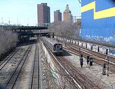
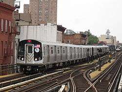
The N train serves the entire BMT Sea Beach Line at all times. | |
| Overview | |
| Type | Rapid transit |
| System | New York City Subway |
| Termini |
Eighth Avenue Coney Island–Stillwell Avenue |
| Stations | 10 |
| Operation | |
| Opened | 1915–1918 |
| Owner | City of New York |
| Operator(s) | New York City Transit Authority |
| Character |
Open-Cut Elevated (at Stillwell Avenue) |
| Technical | |
| Number of tracks | 2-4 |
| Track gauge | 4 ft 8 1⁄2 in (1,435 mm) |
| Electrification | 600V DC third rail |
The BMT Sea Beach Line is a rapid transit line of the BMT division of the New York City Subway, connecting the BMT Fourth Avenue Line at 59th Street via a four-track wide open cut to Coney Island in Brooklyn. It has at times hosted the fastest express service between Manhattan and Coney Island, since there are no express stations along the entire stretch, but now carries only local trains on the N service, which serves the entire line at all times.
Extent and service
| Time period | Section of line | |
|---|---|---|
| all times | full line |
Route description
The modern line begins as a split from the BMT Fourth Avenue Line at a flying junction immediately south of 59th Street. Between the station and the split, crossover switches are provided between the local and express tracks of the Fourth Avenue Line, and then the express tracks curve east under the northbound local track to become the beginning of the Sea Beach Line. After emerging from the tunnel under Fourth Avenue, the two separate Sea Beach tracks rise on either side of a ramp which formerly connected to the original line to the Brooklyn shore at 65th Street in Bay Ridge.[1]
After passing the former junction with the line to the shore, the Sea Beach widens to the width of four tracks. All stations have two side platforms with no platform access to the express tracks anywhere on the Sea Beach right-of-way.[1]
Before and after Kings Highway, there are crossover switches to the southbound express track from the northbound express track. On both sides of Kings Highway, crossovers exist to allow express trains to switch to the local tracks before the station or local trains to switch to express after the station. The express tracks end south of 86th Street as the line becomes double-tracked, and cut diagonally adjacent to the Coney Island Yards. After several yard connections, the line ends at the Coney Island–Stillwell Avenue terminal.[1]
Express tracks
The express tracks were originally intended to host the Coney Island Express. Service was carried on these tracks twice in the line's history — for summer weekend service to Chambers Street from 1924–1952 and again from 1967-1968 to provide a fast rush-hour Broadway Line express service for Coney Island riders (NX). Though these expresses are thought of as being Sea Beach Expresses, they did not serve a single station on the Sea Beach Line.
The express tracks on the Sea Beach had other uses over the years. Most new equipment, especially experimental cars, was broken in on these tracks. The tracks were used for motorman training and set up with a short stretch of 1950s-era automation to test the ill-fated system later used on one track of the IRT 42nd Street Shuttle.
Historically, the two express tracks were an absolute block, that is, there was no signal control between one end of the tracks near Sixth Avenue and Kings Highway. A train was not supposed to enter the block until any train in front of it had departed the block.
The express tracks' section on this block was allowed to deteriorate severely as did much of the system from the 1970s on. In 1998, it was decided to rehabilitate the express tracks in this area, with full signaling. Only the northbound (E4) track was rehabilitated, however, for two-way traffic from its northern end to Kings Highway if needed. The southbound (E3) track remains unused, being disconnected from the other three tracks and inaccessible from 59th Street to Kings Highway.[1]
History
Early history

The New York and Sea Beach Railroad was organized on September 25, 1876 as a steam-powered excursion railroad. It opened from a junction with the Brooklyn, Bath and Coney Island Railroad (West End Line) and concurrently-opened New York, Bay Ridge and Jamaica Railroad (Manhattan Beach Line) to Coney Island on July 18, 1877.[2][3] After a delay of two years, it was opened to the Bay Ridge Ferry (to South Ferry, Manhattan) on July 17, 1879, at which time the Sea Beach Palace opened at the Coney Island end.[4][5][6]
Except at its two ends, the railroad used the same route as the current Sea Beach Line. At the Bay Ridge end, the railroad ran just north of the Long Island Rail Road's Bay Ridge Branch, ending at the Bay Ridge Channel around 64th Street. The current line joins this alignment near Fifth Avenue. The old railroad crossed the Bay Ridge Branch with a pronounced S-curve just east of Seventh Avenue; the crossing is now much straighter with the Bay Ridge Branch in a deeper cut. On the Coney Island end, the original path curved left soon after the curve to the right at the northern edge of the Coney Island Yards, ending at the combined Sea Beach Palace hotel and depot, on the north side of the BMT Brighton Line at around West 10th Street.[6]
On May 22, 1883, the company was reorganized as the New York and Sea Beach Railway Company and was allowed to operate from New York Harbor to the Sea Beach Palace in Coney Island. The company went bankrupt, and a receiver was appointed on January 15, 1896, before the company was sold at foreclosure by the Sea Beach Railway, which was incorporated on August 29, 1896. The Brooklyn Rapid Transit Company (BRT) bought the company's stock on November 5, 1897, along with the short elevated Sea View Railway on Coney Island, and assigned it by lease to the Brooklyn Heights Railroad. It was soon fitted with trolley wire for electric operation. A March 1, 1907 agreement allowed the company to operate through service from 38th Street and New Utrecht Avenue to Coney Island. Starting around 1908, electric trains began operating as a branch of the BMT West End Line from Bath Junction to Coney Island, with trains coming from Park Row in Manhattan via the Brooklyn Bridge and BMT Fifth Avenue Line. Streetcars ran over the rest of the line to Bay Ridge, from New Utrecht Avenue and 62nd Street to 65th Street and Third Avenue. In 1907, connecting tracks were built connecting to the West End Line just north of Coney Island Creek in order to bring Sea Beach trains into West End Depot. The original alignment was retained for freight service only.[6]
The portion of the line between 62nd Street and New Utrecht Avenue and Third Avenue and 65th Street was replaced by bus service between December 1, 1913 and June 23, 1914, when trolley service resumed service before being eliminated on June 22, 1915.[6]
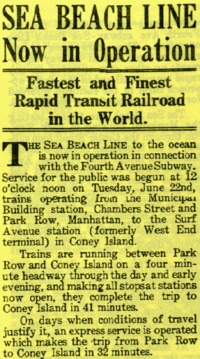
As part of the Dual Contracts, and while the Fourth Avenue Subway Line was being constructed the BRT dug a four-track open cut and built high-level platforms for subway operation on the Sea Beach Line. Trolley cars started using the new open cut between Avenue T and 86th Street on January 9, 1914. Service was gradually extended until the new Sea Beach Line opened for full subway service. Two subway cars with poles were operated between Third Avenue and New Utrecht Avenue started operating on March 16, 1915. Additional cars were equipped with poles and operated service on the line from May 1, 1915 until the line opened for full subway service on June 22, 1915, with trains running between Coney Island and Chambers Street in Lower Manhattan. Service started with two- and three-car trains operating via the Fourth Avenue local track and the Manhattan Bridge south tracks. The express tracks were finished several weeks later. When the BMT Fourth Avenue Line was extended south from the Sea Beach Line on January 15, 1916, the Sea Beach trains were shifted to the express tracks on Fourth Avenue, with Fourth Avenue trains providing local service.[6]
The tracks over the north side of the Manhattan Bridge opened on September 4, 1917, along with part of the BMT Broadway Line. All Sea Beach service was moved to the new line, ending at 14th Street–Union Square. This was extended to Times Square–42nd Street on January 5, 1918.
In 1924 the BMT assigned numbers to its services. The Sea Beach Line service became the 4. This has since become the N train. In general, Sea Beach service has always run express in Manhattan and on Fourth Avenue in Brooklyn, ending at 42nd Street and later 57th Street. The NX began in 1967 as a "super-express" from Brighton Beach on the BMT Brighton Line through Coney Island–Stillwell Avenue, and along the Sea Beach Line express tracks to 57th Street with only seven stops between Stillwell Avenue and 57th Street, three in Brooklyn and four in Manhattan. This service was discontinued in early 1968 due to low ridership, and no regular trains have used the Sea Beach express tracks since.
Later years
In later years, the N service was extended from 57th Street, first to Forest Hills–71st Avenue via the BMT 60th Street Tunnel Connection. In 1987, it was moved to Astoria–Ditmars Boulevard, which is its current terminus, so that the R had access to Jamaica Yard.
| Wikinews has related news: New York City Subway N service to be restored to Coney Island May 29, via the Sea Beach Line |
When Coney Island–Stillwell Avenue was closed for reconstruction from 1993–1995 and 2001–2005, 86th Street was the southern terminal for the N train.[7]
In October 2013, it was announced that the line was going to be renovated extensively. All stations would be waterproofed, with their station houses and passageways remodeled and stairways rebuilt; they would also get Help Points, and turnstiles would be added to each station. In addition, graffiti, which is prevalent on the line, would be mitigated; workers would need to go onto private property to remove graffiti and fix the roofs of the stations, so work would only be done on weekdays. Eighth Avenue would get wheelchair-accessible ramps and New Utrecht Avenue/62nd Street would get wheelchair-accessible elevators. During renovations, northbound platforms at all stations will be closed during the construction. At Bay Parkway and Eighth Avenue, temporary wooden platforms were placed on the southbound express trackbed. The US$300,000,000 project was scheduled to begin in the Winter of 2015.[8] Work began in late June 2015 and is expected to end in September 2018.[9] Funding for the renovation was provided for in the 2010–2014 Capital Program.[10] On January 18, 2016, the Manhattan-bound platforms of all Sea Beach Line stations. At Bay Parkway and Eighth Avenue, temporary wooden platforms were placed on the southbound express trackbed.[11] In 2017 the same Coney Island-bound platforms will close after the renovated Manhattan-bound stations open.
Chaining information
The Sea Beach Line is chained BMT E.[1][12]
Station listing
| Station service legend | |
|---|---|
| |
Stops all times |
| Time period details | |
| Neighborhood | Station | Tracks | Services | Opened | Transfers and notes | |
|---|---|---|---|---|---|---|
| splits from the BMT Fourth Avenue Line (N | ||||||
| Two center express tracks begin (no regular service) (Southbound track disconnected from line; northbound track bi-directional) | ||||||
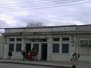
| Sunset Park | Eighth Avenue | local | N |
June 22, 1915 | Manhattan-bound platform closed for renovation. Temporary express platform in use.[11] | |
| Borough Park | Fort Hamilton Parkway | local | N |
June 22, 1915 | Manhattan-bound platform closed for renovation.[11] | |
| Bensonhurst | New Utrecht Avenue | local | N |
June 22, 1915 | BMT West End Line (D Manhattan-bound platform closed for renovation.[11] | |
| 18th Avenue | local | N |
June 22, 1915 | Manhattan-bound platform closed for renovation.[11] | ||
| 20th Avenue | local | N |
June 22, 1915 | Manhattan-bound platform closed for renovation.[11] | ||
| Bay Parkway | local | N |
June 22, 1915 | Manhattan-bound platform closed for renovation. Temporary express platform in use.[11] | ||
| Southbound express track reconnects to line (no regular service) | ||||||
| Gravesend | Kings Highway | local | N |
June 22, 1915 | Manhattan-bound platform closed for renovation.[11] | |
| Avenue U | local | N |
June 22, 1915 | Manhattan-bound platform closed for renovation.[11] | ||
| 86th Street | local | N |
June 22, 1915 | Manhattan-bound platform closed for renovation.[11] | ||
| Center express tracks end | ||||||
| connecting tracks to Coney Island Yard | ||||||
| Coney Island | Coney Island–Stillwell Avenue | all | N |
December 13, 1918 | BMT Brighton Line (Q IND Culver Line (F BMT West End Line (D | |
See also
References
- 1 2 3 4 5 Marrero, Robert (2015-09-13). "469 Stations, 846 Miles" (PDF). B24 Blog, via Dropbox. Retrieved 2015-10-09.
- ↑ ‹The template Cite BDE is being considered for deletion.› "Another Line Open". Brooklyn Daily Eagle. Brooklyn, NY. July 17, 1877. p. 4.
- ↑ ‹The template Cite BDE is being considered for deletion.› "The Sea Beach Railroad". Brooklyn Daily Eagle. Brooklyn, NY. July 19, 1877. p. 2.
- ↑ ‹The template Cite BDE is being considered for deletion.› "Sea Beach". Brooklyn Daily Eagle. Brooklyn, NY. July 15, 1879. p. 2.
- ↑ ‹The template Cite BDE is being considered for deletion.› "The First Train". Brooklyn Daily Eagle. Brooklyn, NY. July 17, 1879. p. 4.
- 1 2 3 4 5 "Two Anniversaries–Sea Beach and Steinway Tunnel". New York Division Bulletin. New York Division, Electric Railroaders' Association. 58 (8). August 2015. Retrieved August 31, 2016 – via Issu.
- ↑ "Noteworthy - N restored to Coney Island". 2005-05-07. Archived from the original on 2005-05-07. Retrieved 2016-09-18.
- ↑ "Two elevators coming to the N line during massive rehabilitation". October 4, 2013. Retrieved May 24, 2014.
- ↑ lvladimirova. "Hazards Of The Sea Beach N Line Stations". Bensonhurst Bean.
- ↑ http://web.mta.info/capital/pdf/CapitalConstruction_1014.pdf
- 1 2 3 4 5 6 7 8 9 10 "N Line Sea Beach - 2016". web.mta.info. Retrieved 2016-01-18.
- "9 Brooklyn N train stations to shut down for 14 months". am New York. 2016-01-14. Retrieved 2016-01-18.
- Katinas, Paula (2014-12-18). "Commuter headache: MTA to renovate N train stations". Brooklyn Daily Eagle. Retrieved 2016-01-18.
- ↑ Korman, Joe. "New York City Subway Chaining". The JoeKorNer. Retrieved May 24, 2014.
Further reading
- Rapid Transit's Coney Island Route, New York Times November 30, 1897 page 4
- Brooklyn's Subway Will Open Today, New York Times June 19, 1915 page 18
- New Subway Opens; Mayor Not Present, New York Times June 20, 1915 page 6
- To Open New Subway Link, New York Times January 14, 1916 page 16
- Open First Section of Broadway Line, New York Times September 5, 1917 page 8
- New Subway Extension, New York Times January 6, 1918 page 37
External links
| Wikimedia Commons has media related to BMT Sea Beach Line. |
- nycsubway.org - BMT Sea Beach Line
- nycsubway.org - Early Rapid Transit in Brooklyn, 1878 to 1913
- rapidtransit.net - BMT Sea Beach Express Tracks
| Services |
|      | ||||||
|---|---|---|---|---|---|---|---|---|
| Stations | ||||||||
| Divisions | ||||||||
| Other lists | ||||||||
| Expansion | ||||||||
| History | ||||||||
| Infrastructure | ||||||||
| Arts and culture | ||||||||
| Miscellaneous | ||||||||
| Other rapid transit in NYC | ||||||||
Companies and predecessors of the Brooklyn–Manhattan Transit Corporation | |||||||
|---|---|---|---|---|---|---|---|
| Elevated Railroads and Subways |
|   | |||||
| Streetcars |
| ||||||
| Buses |
| ||||||
| Streetcar lists | |||||||
| Other |
| ||||||