Pelham Parkway, Bronx
| Pelham Parkway | |
|---|---|
| Neighborhood of The Bronx | |
|
White Plains Road and Pelham Parkway South | |
 Pelham Parkway  Pelham Parkway  Pelham Parkway Location in New York City | |
| Coordinates: 40°51′27″N 73°51′23″W / 40.8575°N 73.856389°WCoordinates: 40°51′27″N 73°51′23″W / 40.8575°N 73.856389°W | |
| Country |
|
| State |
|
| City |
|
| Borough |
|
| Area[1] | |
| • Total | 1.95 km2 (0.754 sq mi) |
| Population (2010)[2] | |
| • Total | 30,073 |
| • Density | 15,000/km2 (40,000/sq mi) |
| Economics | |
| • Median income | $51,004 |
| Ethnicity[3] | |
| • Hispanic | 39.4% |
| • Black | 10.7% |
| • White | 36.2% |
| • Asian | 11.3% |
| • Others | 2.4% |
| ZIP codes | 10461, 10462 |
| Area code | 718, 347, 646 |
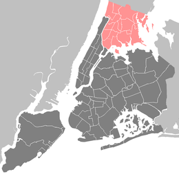
Pelham Parkway is a working- and middle-class residential neighborhood geographically located in the center of the Bronx, a borough of New York City in the United States.[4] The neighborhood is part of Bronx Community Board 11.[5] Its boundaries, starting from the north and moving clockwise are: Waring Avenue to the north, the IRT Dyre Avenue Line tracks (5 train) to the east, Neill Avenue to the South, and Bronx River Parkway to the west. White Plains Road is the primary commercial thoroughfare through Bronx Park East. The local subway line is the IRT White Plains Road Line (2 5 trains) operating along White Plains Road. Zip codes include 10461 and 10462. The area is patrolled by the New York City Police Department 49th Precinct located at 2121 Eastchester Road in the Morris Park section of the Bronx.
Pelham Parkway is a major parkway in the neighborhood, which gives way to the neighborhood's name, originally called The Bronx and Pelham Parkway.
Demographics
Based on data from the 2010 United States Census, the population of Pelham Parkway was 30,073, an increase of 67 (0.2%) from the 30,006 counted in 2000. Covering an area of 531.08 acres (214.92 ha), the neighborhood had a population density of 56.6 inhabitants per acre (36,200/sq mi; 14,000/km2).[2]
The racial makeup of the neighborhood was 36.2% (10,875) White, 10.7% (3,223) African American, 0.2% (59) Native American, 11.3% (3,389) Asian, 0.0% (4) Pacific Islander, 0.7% (196) from other races, and 1.5% (466) from two or more races. Hispanic or Latino of any race were 39.4% (11,861) of the population.[6]
The neighborhood has a significantly diverse population including Albanians (the largest concentration in New York City), Arabs, African Americans, Dominicans, Filipino, Germans, Guyanese, Indians, Irish, Italians, Jamaicans, Jews, Muslims, Pakistanis, Puerto Ricans, and Russians. Hispanics of various races account for 45% of the community; 38% of the community are non-Hispanic White and 20% non-Hispanic Black. Like most neighborhoods in New York City, the vast majority of households are renter occupied. However, there is a large community of co-op owners in the area. There is significant income diversity on a block by block basis, spanning from low wage immigrant households to solid upper middle class. While the poverty rate for The Bronx as a whole is 28%, the poverty rate in the neighborhood, at less than 20%, is much closer to the overall New York City rate of 15%.[7]
Land use and terrain
Pelham Parkway is dominated by 6 and 7-story elevator apartment and coop buildings but the residential streets are lined with a vibrant blend of housing types including detached houses and larger Art Deco and Tudor Style apartment buildings. In the last decade, construction of modern 2 and 3 unit row-houses and apartment buildings have increased the percentage of owners versus renters. The total land area is roughly one square mile. The terrain is relatively low laying and flat.
Bronx Park, on 718 acres (291 ha) along the Bronx River, is the home of the New York Botanical Garden and the Bronx Zoo. Bicycle paths go northwest, north and east, along Mosholu Parkway, Bronx River Parkway and Pelham Parkway respectively. The east end of Fordham Road is inside the park, at an interchange with the Pelham and Bronx River Parkways. The park is operated by the New York City Department of Parks and Recreation. The park is bounded by Southern Boulevard, Webster Avenue, Burke Avenue, Bronx Park East, and East 180th Street. The Bronx Zoo is a subsidiary of the Wildlife Conservation Society which was founded in 1895 as the New York Zoological Society. The Bronx Zoo opened to the public in 1899 and still adheres to its original mission to advance the study of zoology, protect wildlife and educate the public. The zoo is a leader in the care, feeding and exhibition of animals–including mammals, birds, reptiles and amphibians from around the world. With the award winning Congo Gorilla Forest, Tiger Mountain, Jungle World and Baboon Reserve, the Bronx Zoo has earned its place as one of the foremost zoos in the world.[8]
The neighborhood has long served as home to working and middle class New York families. The six-story apartment houses in which they reside provide comfortable living at affordable prices and stand in large numbers throughout the metropolitan area. This commonality of the speculative six-story elevator apartment building has long left this type of construction under-recognized and unappreciated. Though many of these dwellings stand alone or in large concentration; a survey of similar communities affirm that the area is one of few truly cohesive neighborhoods of this typology, offering an unusually compact and well-preserved stretch of these buildings. These structures have proven vital as they contain facilities to meet resident's commercial, religious, and educational needs.[9]
Bronx House, a settlement house that moved to Pelham Parkway in the 1950s is the heart of the neighborhood. It is run by the Federation of Jewish Philanthropies as a community center and provides social services, support networks, English Language classes, free lunches for the elderly, and a gym for all neighborhood residents.[10]
History

The parkway’s official name is the Bronx and Pelham Parkway since it connects Bronx Park and Pelham Bay Park. It is also an integral part of the Mosholu-Pelham Greenway. Pelham Parkway was established in 1911 and was originally only one lane, which is today’s westbound lane. The parkway was one part of John Mullaly's vision of creating a vast system of six parks along with connecting parkway roads to link them.[8][11]
The parkway was lined with trees on both sides and had a strict building code. Nobody was allowed to build within 150 feet (46 m) of the center. No railroads were allowed to cross over the parkway; this is why the roadbed of the New York, Westchester and Boston Railway, which is now the Dyre Avenue subway line, had to be laid in a tunnel underneath the parkway. Bars and hotels are also prohibited alongside the parkway. Land in 1900 cost between $3,500 and $5,000 for one lot; near Bronx Park the prices were even higher. The neighborhood was named after the Parkway.[8]
After a late 20th-century deterioration of the neighborhood, coinciding with what was known as white flight from the Bronx, the Pelham Parkway neighborhood showed signs of revitalization in the new century. Many apartments have been rehabilitated and offered as rentals to the growing middle income population found in the area. A number of buildings have been converted to cooperative ownership and the business section on White Plains Road and Lydig Avenue is a beehive of activity. Their stores reflect the neighborhood's polyglot lineage with many ethnic restaurants side by side with Kosher and Italian butchers and bakeries.[12]
Today’s parkway was constructed in the 1930s and is 2.3 miles (3.7 km) in length and 400 feet (120 m) wide and features wide expanses of lawn with full canopies of trees. The center of the parkway, prior to World War II, was closed off on Sunday mornings for professional bicycle racing. Today, a recreational bikeway runs alongside the westbound motor lanes of the parkway, near the north side of the Parkway.[13]
Education

Christopher Columbus High School is in the neighborhood, on the north side of Pelham Parkway, in 2014 it permanently closed.[14] CUNY Prep High School is in the southwest part of the neighborhood. The Albert Einstein College of Medicine is also nearby.
Transportation
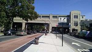
The neighborhood is served by two New York City Subway services serving two New York City Subway lines, as well as local bus route and an express bus to midtown Manhattan. The Pelham Parkway and Bronx Park East stations on the IRT White Plains Road Line (served by the 2 5 trains) and Morris Park on the IRT Dyre Avenue Line (served by the 5 train) service the area.
Two Bronx-Manhattan express buses, the BxM10 (Morris Park Avenue route) and BxM11 (White Plains Road route), provide service to Midtown Manhattan along Fifth Avenue and returns to Pelham Parkway along Madison Avenue. The Bx12 and Bx12 Select Bus Service goes through Bronx Park East on Pelham Parkway, beginning at 207th Street in Manhattan and ending in Bay Plaza (Co-Op City) with transfers to other bus routes on White Plains Road, Williamsbridge Road and Eastchester Road. The buses BX 39,[15] BX 22,[16] BX 31[17] and BX 8[18] also all run through Pelham Parkway.
Notable residents
- Regis Philbin (born 1931), talk show host who grew up on Cruger Avenue between Sagamore Street and Bronxdale Avenue, which has been co-named Regis Philbin Avenue.[19]
References
- ↑ "Pelham Parkway neighborhood in New York". Retrieved September 26, 2015.
- 1 2 Table PL-P5 NTA: Total Population and Persons Per Acre - New York City Neighborhood Tabulation Areas*, 2010, Population Division - New York City Department of City Planning, February 2012. Accessed June 16, 2016.
- ↑ "Center for Urban Research". Retrieved 26 September 2015.
- ↑ NY Times, Living in Pelham Parkway, the Bronx
- ↑ "Bronx Community District 11" (PDF). Retrieved 26 September 2015.
- ↑ Table PL-P3A NTA: Total Population by Mutually Exclusive Race and Hispanic Origin - New York City Neighborhood Tabulation Areas*, 2010, Population Division - New York City Department of City Planning, March 29, 2011. Accessed June 14, 2016.
- ↑ "Pelham Parkway neighborhood in Bronx, New York (NY), 10461, 10462 subdivision profile - real estate, apartments, condos, homes, community, population, jobs, income, streets". city-data.com. Retrieved 4 June 2015.
- 1 2 3 "White Plains Road Business Improvement District - History". pelhamparkway.com. Retrieved 4 June 2015.
- ↑ http://www.arch.columbia.edu/hp/2007pelham.html
- ↑ "Bronx House Website". Retrieved 3 October 2015.
- ↑ "Pelham Parkway History - NYC Parks". Retrieved 30 September 2015.
- ↑ "If You're Thinking of Living In /Pelham Parkway; A Polyglot Enclave In Central Bronx". The New York Times. Retrieved 30 September 2015.
- ↑ "Pelham Parkway Historic Overview". Retrieved 30 September 2015.
- ↑ Beloved Bronx high school named for Christopher Columbus sets sail
- ↑ "MTA Bus Time: Route Bx39". bustime.mta.info. Retrieved 2016-10-23.
- ↑ "MTA Bus Time: Route Bx22". bustime.mta.info. Retrieved 2016-10-23.
- ↑ "MTA Bus Time: Route Bx31". bustime.mta.info. Retrieved 2016-10-23.
- ↑ "MTA Bus Time: Route Bx8". bustime.mta.info. Retrieved 2016-10-23.
- ↑ Jaccarino, Mike. "Regis Philbin wants to save Pelham Parkway trees slated to be cut down by city for guardrail space", New York Daily News, August 13, 2010. Accessed July 1, 2016. "Locals fighting the removal of 87 trees along Pelham Parkway in the Bronx found a champion this week when Philbin bashed the city on his Live with Regis and Kelly show. Philbin grew up in the neighborhood that the picturesque parkway runs through."