Archer Avenue Lines
| BMT/IND Archer Avenue Lines | |
|---|---|
|
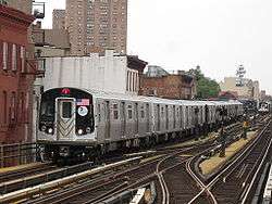
The E, J, and Z trains serve the Archer Avenue Lines. | |
| Overview | |
| Type | Rapid transit |
| System | New York City Subway |
| Locale | Queens |
| Termini |
Parsons/Archer (north) west of Jamaica–Van Wyck (south, upper level) south of Sutphin Boulevard–Archer Avenue–JFK Airport (south, lower level) |
| Stations | 3 |
| Operation | |
| Opened | December 11,1988 |
| Owner | City of New York |
| Operator(s) | New York City Transit Authority |
| Character | Underground |
| Technical | |
| Number of tracks | 2-4 |
| Track gauge | 4 ft 8 1⁄2 in (1,435 mm) |
| Electrification | 600V DC third rail |

Archer Avenue Lines | ||||||||||||||||||||||||||||||||||||||||||||||||||||||||||||||||||||||||||||||||||||
|---|---|---|---|---|---|---|---|---|---|---|---|---|---|---|---|---|---|---|---|---|---|---|---|---|---|---|---|---|---|---|---|---|---|---|---|---|---|---|---|---|---|---|---|---|---|---|---|---|---|---|---|---|---|---|---|---|---|---|---|---|---|---|---|---|---|---|---|---|---|---|---|---|---|---|---|---|---|---|---|---|---|---|---|---|
Legend | ||||||||||||||||||||||||||||||||||||||||||||||||||||||||||||||||||||||||||||||||||||
| ||||||||||||||||||||||||||||||||||||||||||||||||||||||||||||||||||||||||||||||||||||
The Archer Avenue Lines are two rapid transit lines of the New York City Subway, mostly running under Archer Avenue in the Jamaica neighborhood of Queens. Conceived as part of the Metropolitan Transportation Authority's 1968 expansion plans, they opened on December 11, 1988.[1][2]
The two lines are built on separate levels, served by trains from the IND Queens Boulevard Line (E train) on the upper level, and the BMT Jamaica Line (J Z trains) on the lower. Since the two levels share no track connections and have different chainings and radio frequencies, they are two separate lines—the B2 (IND) Division Archer Avenue Line (upper level) and the B1 (BMT) Division Archer Avenue Line (lower level).
Extent and service
The following services use the Archer Avenue Line:
| Service information |
Lines served | Section of line | |
|---|---|---|---|
| Former company | |||
| |
IND | Eighth Avenue Local and Queens Boulevard Express | upper level, north of junction with the IND Queens Boulevard Line |
| |
BMT | Nassau Street and Jamaica Local/Express | lower level, north of 121st Street (at 129th Street) on the BMT Jamaica Line |
The two Archer Avenue Lines begin at a northern (geographic eastern) terminal, Jamaica Center–Parsons/Archer (E J Z trains), as a bi-level subway, each level having two tracks.[3] The two lines run compass west along Archer Avenue to another station at Sutphin Boulevard–Archer Avenue–JFK Airport, where connections can be made to the Long Island Rail Road and AirTrain JFK.[4] West of this station, the two levels diverge. The lower level tracks (J Z trains) continue roughly compass northwest, emerging from a portal near 89th Road and 130th Street and paralleling the Main Line of the LIRR before turning west onto the elevated structure of the BMT Jamaica Line at about 127th Street.[3][4] The upper level tracks (E train) turn compass north under the Van Wyck Expressway, with another station at Jamaica Avenue.[3][4] Just north of Hillside Avenue, they meet the four tracks of the IND Queens Boulevard Line at a flying junction, with connections to both the local and express tracks.[3][4][5]
Jamaica Center–Parsons/Archer was not intended to be the lines' northern terminal, as there are spurs on both levels for possible future extensions. On the lower level, they continue one train length and end with at bumper blocks. This was a planned extension toward 190th Street–Hollis Avenue.[3][6] Where the lower level tracks end, there is a provision for a diamond crossover switch at the end of the tunnel (under 160th Street). On the upper level, the tracks curve south to run under 160th Street and stop at about South Road, also ending at bumper blocks.[7][3][8][9][6] The plan was for this line to use the LIRR Atlantic Branch ROW and run to Springfield Boulevard or Rosedale. Where the upper level tracks stub end, there is a provision for a portal to go outside if the line going to Southeastern Queens is ever built.[3][8][6] The tail tracks on both levels are currently used for storage.[5][6]
History
Planning
What is now the Archer Avenue subway was originally conceived as an extension of the IND Queens Boulevard Line under the IND Second System in the 1920s and 1930s. The original plans had a line diverging south of Van Wyck Boulevard station (now called Briarwood), running down what is now the Van Wyck Expressway to Rockaway Boulevard near modern John F. Kennedy International Airport. A bellmouth with two additional trackways was built into the station to facilitate this extension, which was never constructed due to lack of funding.[5]
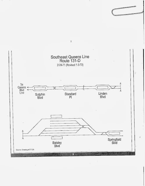
The current Archer Avenue plans emerged in the 1960s under the city and MTA's Program for Action. It was conceived as an expansion of Queens Boulevard service to a "Southeast Queens" line along the right-of-way of the Long Island Rail Road Atlantic Branch towards Locust Manor, and as a replacement for the dilapidated eastern portions of the Jamaica Avenue elevated within the Jamaica business district which business owners and residents sought removal of; both would meet at the double-decked line under Archer Avenue. The two-track spur from the Queens Boulevard Line would use the original Van Wyck Boulevard bellmouths.[3][5][6][10][11][12] The lines and the Jamaica El removal were part of urban renewal efforts in the Downtown Jamaica area. This included the construction of the York College campus, which was planned to be built in conjunction with the LIRR Atlantic Branch connection.[6][12][13]
The original plan for the upper level (now the E train) was for it to continue as a two-track line along the LIRR Atlantic Branch. It would have run through Locust Manor and Laurelton stations, with stops at Sutphin, Parsons, Linden, Baisley, and Springfield Boulevards.[14] The line would have served a large-scale housing development at Rochdale Village; such a line would have required conversion involving modifying existing platforms at Locust Manor and Laurelton to accommodate the IND loading gauge, as well as constructing new stations to serve Southeast Queens. It would have also run parallel to the eastern Montauk Branch, which already provided parallel service through St. Albans to Jamaica. The lower level (now the J Z trains) would have been extended eastward toward 190th Street – Hollis Avenue (near the Hollis LIRR station). Due to a lack of funding as well as some political opposition, these plans were never implemented.[5][3][10]
Construction and opening
Construction on the Archer Avenue subway began on October 23, 1973 at 159th Street and Beaver Road, just south of Archer Avenue, paving the way for the southeast Queens subway line and the demolition of the Jamaica Avenue Elevated from 129th Street to the 168th Street terminal. It was then expected that the subway would be complete by 1980 or 1981;[3] the Jamaica elevated between Queens Boulevard and 168th Street was closed in September 1977.[11] The first tunnel between the Jamaica Avenue Elevated and the Archer Avenue subway was holed through in October 1977. The second tunnel connection holing through of the Archer Avenue subway tunnels occurred in December 1977. In October 1979, groundbreaking for a 1,300 feet (396 m) cut-and-cover section of the Archer Avenue line occurred, which would connect the line with the IND Queens Boulevard Line. This section also included the Jamaica–Van Wyck station. Most of the project was constructed via cut-and-cover methods, with portions of the lines excavated with tunneling shield methods.[6]
In October 1980, the MTA considered stopping work on the line, due to its budget crisis and the bad state of the existing subway system. Originally set to be opened in 1980, the line kept getting delayed, and by the late 1970s, the opening was delayed to 1983, then to 1985 or 1986.[15] Progress of the Archer Avenue Line temporarily stopped in March 1982, when on March 5th, part of the tunnel caved in around the vicinity of Archer Avenue and 138th Street, where one construction worker was killed, and three others narrowly escaped injury.[16]
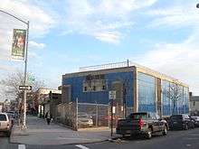
Despite the delays, disagreements over the condition of the line and the speed of construction, and the federal Urban Mass Transportation Administration's reluctance to provide funding to complete the line due to concerns over the quality of concrete and the leakage of water into the tunnels, construction was completed a year ahead of schedule, in 1983.[17] Due to the city's fiscal crisis, the subway line was truncated to Jamaica Center–Parsons/Archer.[2] The line, which consisted of the first stations added to the subway system since the 57th Street station opened in 1968, and the first stations in Queens since the IND Rockaway Line in 1956, opened on December 11, 1988—at a cost of nearly five times its original budgeted cost and severely cut back to a length of 2 miles (3 km).[2][18]
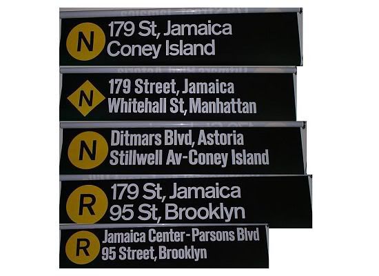
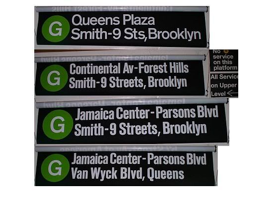
In the original service plan, the G and N local trains (the N ran on the IND Queens Boulevard Line until 1987, when the R train replaced the N to allow it access to the Jamaica Yard) were to serve the Archer Avenue upper level,[19][20] while the E and F express trains would have remained on the Queens Boulevard mainline towards 179th Street. The N train was to run between Jamaica Center and Coney Island during weekdays while G trains were to terminate at 71st Avenue. During weekends the G train was to run between Jamaica Center and Smith–Ninth Streets, while N trains would terminate at 57th Street–Seventh Avenue or 71st Avenue. During late nights there was supposed to be a G train shuttle between Jamaica Center and Van Wyck Boulevard.[21] The signage indicating such service was installed inside the Kew Gardens – Union Turnpike station in the mid-1980s. When the Archer Avenue Line opened in 1988, a simpler service plan was put into effect, which involved the E going to Jamaica Center and the F going to 179th Street, with all local service terminating at 71st Avenue.[2] That plan remains as of September 2016.
Station listing
| Station service legend | |
|---|---|
| |
Stops all times |
| |
Stops rush hours in the peak direction only |
| Time period details | |
| Neighborhood (approximate) |
Station | Tracks | Services | Opened | Transfers and notes | |
|---|---|---|---|---|---|---|
| Jamaica | Jamaica Center–Parsons/Archer | all | E |
December 11, 1988 | Q44 Select Bus Service | |
| Sutphin Boulevard–Archer Avenue–JFK Airport | all | E |
December 11, 1988 | Q44 Select Bus Service Connection to LIRR at Jamaica Connection to | ||
| Merge into BMT Jamaica Line (lower level) (J | ||||||
| Jamaica–Van Wyck | upper level | E |
December 11, 1988 | |||
| Merge into IND Queens Boulevard Line (upper level) (E | ||||||
References
- ↑ Johnson, Kirk (1988-12-09). "Big Changes For Subways Are to Begin". The New York Times. Retrieved 2009-07-05.
- 1 2 3 4 Johnson, Kirk (1988-12-09). "Big Changes For Subways Are to Begin". The New York Times. ISSN 0362-4331. Retrieved 2016-06-06.
- 1 2 3 4 5 6 7 8 9 10 Burks, Edward C. (October 24, 1973). "Work Begun on Queens Subway Extension". The New York Times. Retrieved 26 September 2015.
- 1 2 3 4 "MTA Neighborhood Maps: Jamaica" (PDF). mta.info. Metropolitan Transportation Authority. 2015. Retrieved 30 June 2015.
- 1 2 3 4 5 Joseph B. Raskin (1 November 2013). The Routes Not Taken: A Trip Through New York City's Unbuilt Subway System. Fordham University Press. ISBN 978-0-8232-5369-2. Retrieved 12 August 2015.
- 1 2 3 4 5 6 7 Archer Ave Route (proposed) Construction, Queens: Environmental Impact Statement. Urban Mass Transit Administration, United States Department of Transportation. August 1973. Retrieved 6 August 2016.
- ↑ Final Environmental Statement Archer Avenue Route. Urban Mass Transportation Administration
U.S. Department of Transportation. March 1974 – via Hathitrust. - 1 2 Burks, Edward C. (March 9, 1975). "Building Progresses On Subway In Jamaica". The New York Times. Retrieved 27 September 2015.
- ↑ Burks, Edward C. (September 24, 1976). "Coming: Light at End of 63d St. Tunnel". The New York Times. Retrieved 27 September 2015.
- 1 2 nycsubway.org—The 1968 MTA "Program for Action"
- 1 2 Dembart, Lee (September 9, 1977). "A Sentimental Journey on the BMT...". nytimes.com. The New York Times. Retrieved 2 July 2015.
- 1 2 "Full text of "Metropolitan transportation, a program for action. Report to Nelson A. Rockefeller, Governor of New York."". Internet Archive. November 7, 1967. Retrieved October 1, 2015.
- ↑ Clines, Francis X. (November 24, 1970). "City Board Approves York College Campus Plan". The New York Times. Retrieved 6 August 2016.
Designed in conjunction with a planned IND subway station for the area
- ↑ "http://1.bp.blogspot.com/-KeE0zA-o9eQ/UkwMlD5iQgI/AAAAAAAACtM/rJZIo37CvK8/s640/southwest_route.jpg". External link in
|title=(help) - ↑ "Jamaica Subway Under Way". The New York Times. July 8, 1973.
- ↑ "Dies in Cave-In: Sand Avalanche Buries Worker in Queens IND," New York Daily News, March 5th, 1982, page 3.
- ↑ Schmalz, Jeffrey (August 18, 1985). "U.S. HOLDS UP AID FOR SUBWAY WORK". The New York Times.
- ↑ "New Subway Line Finally Rolling Through Queens," Newsday, December 11th, 1988, page 7.
- ↑ "http://img.photobucket.com/albums/v93/GP36Chris/Subway/roll2.jpg". External link in
|title=(help) - ↑ "http://img.photobucket.com/albums/v93/GP36Chris/Subway/roll3.jpg". External link in
|title=(help) - ↑ "R46 Jamaica Image 14".
External links
-
 Media related to Archer Avenue Line at Wikimedia Commons
| Services |
|      | ||||||
|---|---|---|---|---|---|---|---|---|
| Stations | ||||||||
| Divisions | ||||||||
| Other lists | ||||||||
| Expansion | ||||||||
| History | ||||||||
| Infrastructure | ||||||||
| Arts and culture | ||||||||
| Miscellaneous | ||||||||
| Other rapid transit in NYC | ||||||||