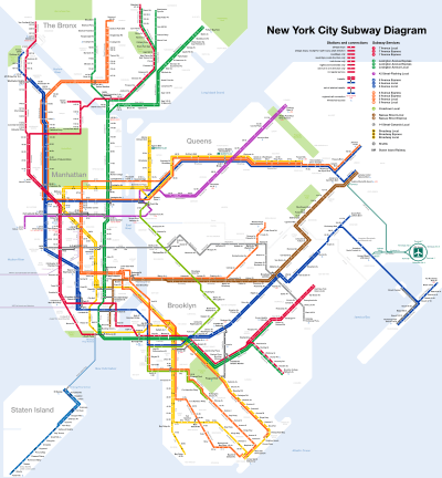
New York City Subway stations
The New York City Subway is a rapid transit system that serves four of the five boroughs of New York City, New York: the Bronx, Brooklyn, Manhattan, and Queens.[1] Its operator is the New York City Transit Authority, which is itself controlled by the Metropolitan Transportation Authority of New York. In 2015, an average of 5.65 million passengers used the system daily, making it the busiest rapid transit system in the United States and the seventh busiest in the world.[2][3]
The present New York City Subway system is composed of three formerly separate systems that merged in 1940: the Interborough Rapid Transit Company (IRT), the Brooklyn–Manhattan Transit Corporation (BMT), and the Independent Subway System (IND). The privately held IRT, founded in 1902, constructed and operated the first underground railway line in New York City.[4] The opening of the first line on October 27, 1904 is commonly cited as the opening of the modern New York City Subway, although some elevated lines of the IRT and BMT that were initially incorporated into the New York City Subway system but then demolished predate this. The oldest sections of elevated lines still in operation were built in 1885. The BMT, founded in 1923 and also privately held, was formed from the bankruptcy of the Brooklyn Rapid Transit Company. The IND was created by the City of New York in 1921 to be a municipally owned competitor of the two private companies. Unification in June 1940 by the New York City Board of Transportation brought the three systems under one operator. The New York City Transit Authority, created in 1953 to be a public benefit corporation that acquired the rapid transit and surface line (buses and streetcars) infrastructure of the Board of Transportation, remains the operator of the New York City Subway today.
The official count of stations is 469; however, this tabulation classifies some transfer stations as two or more stations, which are called "station complexes" within the nomenclature of the New York City Subway. If station complexes are counted as one station each, the number of stations is 422. 32 such station complexes exist. The reason for the higher count generally lies in the history of the New York City Subway: IRT, BMT and IND stations are usually counted separately, particularly if their lines are not parallel and are adjacent to or on another level to each other. Regardless of how stations are counted, the New York City Subway has the largest number of rapid transit stations in the world.
Included in the station counts is one station that is temporarily closed: Cortlandt Street on the IRT Broadway–Seventh Avenue Line. The station closed when it was destroyed during the September 11, 2001 attacks. There are numerous other New York City Subway stations that are closed, many of which stem from the demolition of elevated lines once operated by the IRT and the BMT that were made largely but not completely redundant to underground lines subsequently constructed. The newest New York City Subway station is 34th Street–Hudson Yards, which opened on September 13, 2015.
The Metropolitan Transportation Authority is currently building three new New York City Subway stations as part of the Second Avenue Subway, a long-deferred project intended to relieve congestion on the IRT Lexington Avenue Line (4 5 6 <6> trains), the busiest rapid transit corridor in the United States. The stations will be located on Second Avenue at 72nd, 86th and 96th streets.
Stations that share identical street names are disambiguated by the line name and/or the cross street each is associated with. For example, "125th Street station" can refer to four separate stations: 125th Street on the IND Eighth Avenue Line (A B C D trains), the IRT Broadway–Seventh Avenue Line (1 train), the IRT Lenox Avenue Line (2 3 trains), and the IRT Lexington Avenue Line (4 5 6 <6> trains).[5] This situation occurs numerous times.
Station facilities and amenities
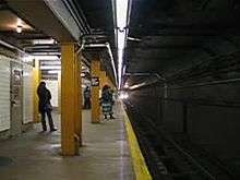
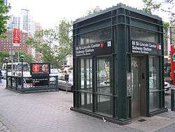
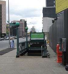
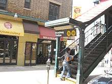
467 of the 469 stations in the system are served 24 hours a day.[note 1] Underground stations in the New York City Subway are typically accessed by staircases going down from street level. Many of these staircases are painted in a common shade of green, with slight or significant variations in design.[6] Other stations have unique entrances reflective of their location or date of construction. Several station entrance stairs, for example, are integrated into adjacent buildings.[6] Nearly all station entrances feature color-coded globe or square lamps signifying their status as an entrance (see below).[7]
Entrances
Turnstiles and entrance gates
The New York City Subway primarily employs two types of turnstiles: a waist-high turnstile, and a full-height turnstile known as a High Entry-Exit Turnstile (HEET). The waist-high turnstiles, the most prominent in the system, were installed beginning in 1993 along with the implementation of MetroCard, though they originally accepted tokens.[8] The newer HEETs resemble several older turnstiles of that design informally called "iron maidens", and are prevalent at subway entrances without token booths to discourage fare evasion.[9] Both turnstiles are stainless steel and are bidirectional, allowing passengers to enter with fare payment and to exit. A third older type of turnstile, the High Exit Turnstile (HET), is a black-painted unidirectional iron maiden and only turns in the exiting direction.[9] Entrance is also available via Service Entry gates or AutoGates, which cater primarily to handicapped passengers[10][11][12] or passengers with large items such as strollers and luggage. These gates double as pushbar Emergency Exits, though they are often used for regular exiting in crowded stations.[13]
Lamps
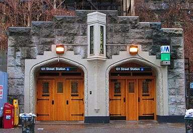
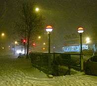
At most of the system's entrances and exits, there is a lamppost or two bearing a colored spherical or cube-shaped lamp. These lights roughly indicate the station's availability (i.e. how often it is accessible): green means a full-time entrance and booth, red means either a part-time booth or no booth, hence either exit-only or entrance with MetroCard. Older lamps are completely colored green or red, while newer ones, called "half-moons", have only the top half colored, while the bottom half is milky white; this is to provide more light, and the half-colored globes have the same meanings as the globes with full colors.[7] There are also some square lamps.
The meaning of the lights is poorly understood by passengers, and was originally more complicated. Green, yellow, and red lights were introduced in the early 1980s to indicate the entrance's availability, mostly to prevent muggings by warning riders away from entrances that were closed at night. Originally, green signified an entrance located at a full-time station booth, which was open 24/7 and had regular waist-high turnstiles; yellow signified a part-time booth, to which access to the platforms could be gained using High Entry-Exit Turnstiles (HEETs); and red signified an exit-only.[7][14] This proved too complicated and yellow was dropped in the early 1990s. Red globes now indicate both part-time entrance or exit-only;[15] indeed, a joke when the system was introduced was that "green meant go in, red meant don't. And yellow meant take a [yellow New York City taxi] cab."[7]
Further, with the introduction of the MetroCard in 1994, the MTA converted many previous exit-only entrances to full-time entrances via HEETs.[9] The introduction of half-colored globes further confused riders of the subway system, and as of a 2002 survey, the globe lamps are poorly understood.[note 2]
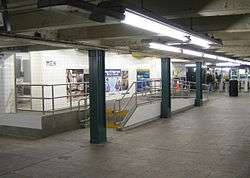
Concourse

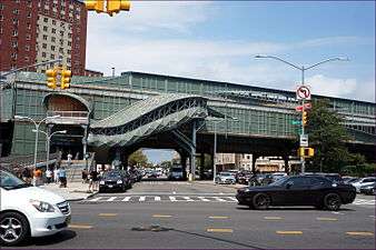
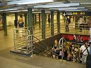
Many stations in the subway system have mezzanines.[9] In underground stations, this typically consists of the first level below the street or the areas between the street and platform level. For open-cut, grade-level and elevated stations, prevalent in uptown Manhattan and the outer boroughs, the mezzanine area often consists of a station house at street level or above the street.[16][17] Mezzanines allow for passengers to enter from multiple locations at an intersection and proceed to the correct platform without having to cross the street before entering. At busy intersections, they also act as a pedestrian underpass or overpass. They also allow for crossover between uptown and downtown trains on side platforms or a pair of island platforms, which is very useful when local tracks are closed for construction. Within the mezzanines are fare control areas, where passengers physically pay their fare to enter the subway system.[9][18][19] In underground subway stations built close to ground level or under narrow streets, a characteristic of early IRT and BMT construction, the fare control area is at platform level with no mezzanine crossovers.[20][19] Many elevated stations also have platform-level fare control with no common station house between directions of service.[21]
Upon entering a station, passengers may use station booths (formerly known as token booths)[22] or vending machines to buy their fare, which is currently stored in a MetroCard. Each station has at least one booth, typically located at the busiest entrance.[23] After swiping the card at a turnstile, customers enter the fare-controlled area of the station and continue to the platforms.[10] Inside fare control are "Off-Hours Waiting Areas", which consist of benches and are identified by a yellow sign.[10][24]
For various reasons, including maintenance costs, decreases in ridership, along with crime and safety issues, many stations have fare control areas, mezzanine areas and entrances that have been closed.[25][26][27] Many mezzanines that previously stretched the entire length of a station have been split or partitioned by fencing or permanent walls. These closed areas have been abandoned or converted into space for Transit Operations or the New York City Police Department.[9][18]
_by_David_Shankbone.jpg)
Facilities and amenities
Air conditioning
In August 2006, the MTA announced that all future subway stations, which include 34th Street–Hudson Yards, South Ferry, and all Second Avenue Subway stations, will have platforms outfitted with air-cooling systems.[28][29] The existing Grand Central–42nd Street station also has these cooling systems; however, for the most part, subway stations lack air-cooling systems due to their expense, and only a few stations have ceiling fans.[30]
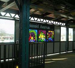
Artwork
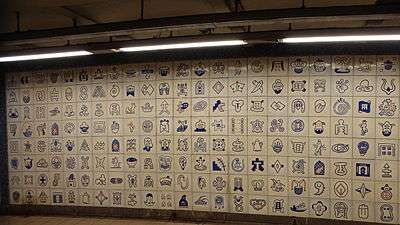
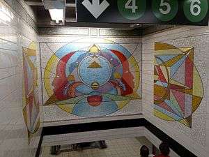
Many stations are decorated with intricate ceramic tile work, some of it dating back to 1904 when the subway first opened. The subway tile artwork tradition continues in a Percent for Art program.
The MTA Arts & Design program oversees art in the subway system.[31] Permanent installations, such as sculpture, mosaics, and murals; photographs displayed in lightboxes encourage people to use mass transit.[32][33] In addition, commissioned art displayed in stations and "art cards", some displaying poetry, are in many of the trains themselves in unused advertisement fixture slots. Some of the art is by internationally known artists such as Elizabeth Murray's Blooming, displayed at Lexington Avenue/59th Street station.[34]


Accessibility
Since the majority of the system was built before 1990, the year the Americans with Disabilities Act (ADA) went into effect, many New York City Subway stations were not designed to be handicapped-accessible. Since then, elevators have been built in newly constructed stations to comply with the ADA. (Most grade-level stations required little modification to meet ADA standards.) In addition, the MTA identified "key stations", high-traffic and/or geographically important stations, which must conform to the ADA when they are extensively renovated. As of December 2015, out of 469 total stations in the system, 112 are accessible;[lower-alpha 1] many of them have AutoGate access.[35][36][37] Four stations on the Staten Island Railway are also accessible. Additionally, there are 16 more non-ADA-accessible stations with cross-platform interchanges, as well as other same-platform transfers, designed to handle wheelchair transfers.[37]
Entertainment
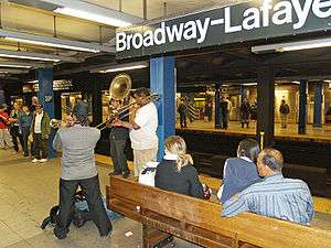
Since 1987, MTA has sponsored the "Music Under New York" (MUNY) program[38] in which street musicians enter a competitive contest to be assigned to the preferred high traffic locations. Each year, applications are reviewed and approximately 70 eligible performers are selected and contacted to participate in live auditions held for one day.[39][40][41][42]
At present, more than 100 soloists and groups participate in MUNY providing over 150 weekly performances at 25 locations throughout the transit system, for example Natalia Paruz, a musical saw player, plays at Union Square. In addition, any musician/entertainer may perform in subway mezzanines and platforms. On platforms, there may be no amplifications as this is part of MTA policies:
The New York City Transit (NYCT) is a subdivision of the Metropolitan Transportation Authority (MTA) that operates the city's subways and buses. The NYCT authorizes these types of free expression in subway stations: "Public speaking; distribution of written materials; solicitation for charitable, religious or political causes; and artist performances, including the acceptance of donations."
Performers must not be within 25 feet (7.6 m) of a token booth or 50 feet (15 m) from an MTA office/tower, blocking access to an escalator, stairwell, or elevator, interfering with transit services or passenger movement; or in an area where construction is occurring. In addition, performance is prohibited during public service announcements and may be no louder than 85 dBA at 5 feet (1.5 m) away or 70 dBa at 2 feet (0.61 m) from a token booth. Performances are prohibited in subway cars.[43]
Restrooms
Restrooms are rare in the subway system as only 129 open restrooms are in 77 of the system's 469 stations.[44] Most station restrooms previously open to the public have been closed to the public and converted to storage spaces or for employee use only.[45] However, there are a few major stations that have operating restrooms, including on the concourses of 42nd Street–Port Authority Bus Terminal; Chambers Street; 57th Street–Seventh Avenue; Coney Island–Stillwell Avenue; and Lexington Avenue/59th Street.[46] The majority of restrooms in the New York City Subway are found in express and transfer stations, at ADA-accessible stations, and at terminals, though not all of the aforementioned types of stations have restrooms.[47]
Newer subway stations have restrooms, including 34th Street–Hudson Yards on the IRT Flushing Line[48] and three future Second Avenue Subway stations.[49]
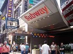
Retail
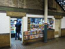
Some platforms have newspaper stands that sell various items including newspapers and food. The MTA also installed retail spaces within paid areas in selected stations, including the station concourses of the Times Square complex and the Sixth Avenue concourse at 42nd Street–Bryant Park.
According to the MTA, the New York City Subway is home to 345 retail spaces, making over US$70 million in rent and licensing fees in 2009 for the authority. It is continuing to make efforts in attracting more diverse retailers and vendors to set up shop in the subway system.[50][51]
Connections
Rapid transit and rail connections are available at designated stations to Amtrak, Long Island Rail Road, AirTrain JFK, Metro-North Railroad, New Jersey Transit and PATH. Connections to the Staten Island Ferry and privately operated ferries such as NY Waterway and New York Water Taxi, as well as intercity and commuter bus lines at the Port Authority Bus Terminal and George Washington Bridge Bus Terminal, are also available. Free MetroCard-only transfers to buses are available to MTA New York City Transit buses (including the bus rapid transit Select Bus Service), MTA Bus Company, NICE buses (Nassau County) and Bee-Line buses (Westchester County).[52]
Station platforms and configurations
NYCS station configurations | |||||||||||||||||||||||||||||||||||||||||||||||||||||||||||||||||||||||||||||||
|---|---|---|---|---|---|---|---|---|---|---|---|---|---|---|---|---|---|---|---|---|---|---|---|---|---|---|---|---|---|---|---|---|---|---|---|---|---|---|---|---|---|---|---|---|---|---|---|---|---|---|---|---|---|---|---|---|---|---|---|---|---|---|---|---|---|---|---|---|---|---|---|---|---|---|---|---|---|---|---|
Legend | |||||||||||||||||||||||||||||||||||||||||||||||||||||||||||||||||||||||||||||||
| Station with 2 tracks and 2 side platforms | |||||||||||||||||||||||||||||||||||||||||||||||||||||||||||||||||||||||||||||||
| |||||||||||||||||||||||||||||||||||||||||||||||||||||||||||||||||||||||||||||||
| Station with 2 tracks and one island platform | |||||||||||||||||||||||||||||||||||||||||||||||||||||||||||||||||||||||||||||||
| |||||||||||||||||||||||||||||||||||||||||||||||||||||||||||||||||||||||||||||||
| Local station with 3 tracks | |||||||||||||||||||||||||||||||||||||||||||||||||||||||||||||||||||||||||||||||
| |||||||||||||||||||||||||||||||||||||||||||||||||||||||||||||||||||||||||||||||
| Express station with 3 tracks | |||||||||||||||||||||||||||||||||||||||||||||||||||||||||||||||||||||||||||||||
| |||||||||||||||||||||||||||||||||||||||||||||||||||||||||||||||||||||||||||||||
| Local station with 4 tracks | |||||||||||||||||||||||||||||||||||||||||||||||||||||||||||||||||||||||||||||||
| |||||||||||||||||||||||||||||||||||||||||||||||||||||||||||||||||||||||||||||||
| Express station with 4 tracks (typical configuration) | |||||||||||||||||||||||||||||||||||||||||||||||||||||||||||||||||||||||||||||||
| |||||||||||||||||||||||||||||||||||||||||||||||||||||||||||||||||||||||||||||||
| |||||||||||||||||||||||||||||||||||||||||||||||||||||||||||||||||||||||||||||||
| DeKalb Avenue station (only weekday services shown) | |||||||||||||||||||||||||||||||||||||||||||||||||||||||||||||||||||||||||||||||
| |||||||||||||||||||||||||||||||||||||||||||||||||||||||||||||||||||||||||||||||
Out of the system's 469 stations, 280 are underground,[note 3] 149 are elevated, 20 are in open cuts, 7 are at-grade,[note 4] and 13 are on embankments.[note 5]
|
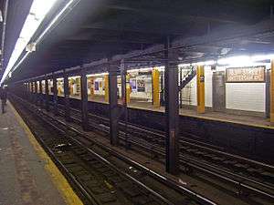


A typical subway station has waiting platforms ranging from 480 to 600 feet (150 to 180 m) long, though some IND platforms may be as long as 660 to 745 feet (201 to 227 m) long.[53][54] Platforms of former commuter rail stations, such as those on the IND Rockaway Line, are even longer. Due to the large number of transit lines, one platform or set of platforms often serves more than one service (unlike other rapid transit systems including the Paris Metro, but like some lines on the London Underground). A passenger needs to look at the signs hung at the platform entrance steps and over each track to see which trains stop there and when, and at the arriving train to see which train it is.
Almost everywhere expresses run, they run on the inner one (of 3) or two (of 4) tracks, and locals run on the outer two tracks. In a 3-track configuration, the center track can be used toward the center of the city in the morning and away from the center in the evening, though not every 3-track line has that express service.
There are a number of common platform configurations:
- On a 2-track line, a station may have one center island platform used for trains in both directions, or 2 side platforms, one for a train in each direction.
- For a 3-track or 4-track line, local stops will have side platforms and the middle one or two tracks will not stop at the station.
- For most 3- or 4-track express stops, there will be two island platforms, one for the local and express in one direction, and another for the local and express in the other direction. Each island platform provides a cross-platform interchange between the local and express services.
In a few cases, a 4-track station has an island platform for the center express tracks and two side platforms for the outside local tracks. This occurs only at three stations near major railway stations where the next station along the line is also an express station with the more common platform configuration. The purpose of splitting the platforms is to limit overcrowding by preventing cross-platform interchanges between local and express services. This occurs at Atlantic Avenue–Barclays Center on the IRT Eastern Parkway Line (2 3 4 5 trains) with an adjacent express station at Nevins Street, where the connection is to the Atlantic Terminal of the Long Island Rail Road; and 34th Street–Penn Station on both the IRT Broadway–Seventh Avenue Line (1 2 3 trains) and IND Eighth Avenue Line (A C E trains), with adjacent express stations at Times Square–42nd Street and 42nd Street–Port Authority Bus Terminal, where the connection is to Pennsylvania Station, one of the two major New York City railway stations. This does not occur with the connection to New York's other major station, Grand Central Terminal, at Grand Central on the IRT Lexington Avenue Line (4 5 6 <6> trains), which has no adjacent express station.
There is one notable 6-track local station, DeKalb Avenue on the BMT Fourth Avenue Line, where trains to or from the Manhattan Bridge either stop at the outer tracks of the island platforms (B Q trains), or pass through and bypass the station on the middle tracks ("bypass express tracks") (D N trains). Trains to or from the Montague Street Tunnel ( R train) stop across the platform from the respective outer track.
Stations with two levels
Some stations have two levels. The levels separate the platforms of different services and/or directions. For example:
- the local trains on one level and the express trains on another level
- trains of two different lines on two different levels
- trains of two different directions on two different levels, with a cross-platform interchange on each level
- trains of different services on two different levels that are on the same line
Complete lists of stations
The complete list of stations is split by borough. The second column displays the number of stations as counted by the Metropolitan Transportation Authority. The third column shows the number of stations when "station complexes" are considered to be one station each.
| Borough | Number of stations | Number of stations | Station complexes | Services |
|---|---|---|---|---|
| The Bronx | 70 | 68 | 2 | 1 2 4 5 6 <6> B D |
| Brooklyn | 170 | 157 | 10 | 2 3 4 5 A B C D |
| Manhattan | 148 | 119 | 18 | 1 2 3 4 5 6 <6> 7 |
| Queens | 81 | 78 | 2 | 7 <7> A E F G J |
| All | 469 | 422 | 32 | 1 2 3 4 5 6 <6> 7 |
Station complexes
The New York City Subway has several types of transfer stations, among them station complexes (i.e. sets of two or more stations connected with a passageway inside fare control) and stations serving two or more lines (considered to be one station each). The table below only lists the station complexes. For a more detailed list see the main article.
Stations with the same name

There are many stations that share the same name. These stations are disambiguated by the line each of them is on. The following list shows these occurrences presented alphabetically by borough, then west to east, then north to south; stations of the same name that form a subway complex are grouped in parentheses (); demolished and permanently closed stations are stricken through; future stations are in italics:
- The 5 on each of its two northern branches in the Bronx stops at two stations that bear the same name: Gun Hill Road on the Dyre Avenue Line and the White Plains Road Line, and Pelham Parkway on the Dyre Avenue Line and the White Plains Road Line.
- The B stops at two stations named Seventh Avenue: Seventh Avenue (BMT Brighton Line) in Brooklyn and Seventh Avenue (IND Sixth Avenue Line) in Manhattan.
- The D stops at three stations named 50th Street: 47th–50th Streets–Rockefeller Center (IND Sixth Avenue Line) in Manhattan, and 50th Street (BMT West End Line) in Brooklyn.
- The E stops at two stations named 23rd Street: 23rd Street (IND Eighth Avenue Line) in Manhattan and Court Square–23rd Street (IND Queens Boulevard Line) in Queens.
- The M stops at two stations named Myrtle Avenue: Myrtle Avenue–Broadway (BMT Jamaica Line) and Myrtle–Wyckoff Avenues (BMT Myrtle Avenue Line), both in Brooklyn. It also stops at two stations named 23rd Street: 23rd Street (IND Sixth Avenue Line) in Manhattan and Court Square–23rd Street (IND Queens Boulevard Line) in Queens.
- The R stops at two stations named 36th Street: 36th Street (BMT Fourth Avenue Line) in Brooklyn and 36th Street (IND Queens Boulevard Line) in Queens.
- Dyckman Street and Bedford Park Boulevard were both originally known as 200th Street.
Top stations by ridership
These tables list the top ten New York City Subway stations by annual, average weekday, and average weekend ridership in 2015.[2]
| Rank | Station | Annual ridership (2015) |
|---|---|---|
| 1 | Times Square–42nd Street/42nd Street–Port Authority Bus Terminal | 66,359,208 |
| 2 | Grand Central–42nd Street | 46,737,564 |
| 3 | 34th Street–Herald Square | 39,541,865 |
| 4 | 14th Street–Union Square | 35,320,623 |
| 5 | 34th Street–Penn Station (Seventh Avenue) | 28,309,160 |
| 6 | 34th Street–Penn Station (Eighth Avenue) | 26,147,434 |
| 7 | 59th Street–Columbus Circle | 23,299,666 |
| 8 | Fulton Street | 21,671,684 |
| 9 | Lexington Avenue/59th Street | 21,407,792 |
| 10 | 86th Street (Lexington Avenue) | 20,890,828 |
| Rank | Station | Average weekday ridership (2015) |
|---|---|---|
| 1 | Times Square–42nd Street/42nd Street–Port Authority Bus Terminal | 206,247 |
| 2 | Grand Central–42nd Street | 160,294 |
| 3 | 34th Street–Herald Square | 126,776 |
| 4 | 14th Street–Union Square | 108,440 |
| 5 | 34th Street–Penn Station (Seventh Avenue) | 92,176 |
| 6 | 34th Street–Penn Station (Eighth Avenue) | 84,778 |
| 7 | Fulton Street | 74,676 |
| 8 | 59th Street–Columbus Circle | 73,954 |
| 9 | Lexington Avenue/51st–53rd Streets | 70,686 |
| 10 | Lexington Avenue/59th Street | 68,988 |
| Rank | Station | Average weekend ridership (2015) |
|---|---|---|
| 1 | Times Square–42nd Street/42nd Street–Port Authority Bus Terminal | 253,004 |
| 2 | 14th Street–Union Square | 143,123 |
| 3 | 34th Street–Herald Square | 132,961 |
| 4 | Grand Central–42nd Street | 109,137 |
| 5 | 34th Street–Penn Station (Seventh Avenue) | 88,770 |
| 6 | 34th Street–Penn Station (Eighth Avenue) | 83,698 |
| 7 | 59th Street–Columbus Circle | 82,220 |
| 8 | 86th Street (Lexington Avenue) | 76,054 |
| 9 | 74th Street–Broadway/ | 73,373 |
| 10 | Lexington Avenue/59th Street | 71,184 |
See also
- List of New York City Subway transfer stations
- List of New York City Subway terminals
- List of accessible New York City Subway stations
- List of closed New York City Subway stations
- List of Staten Island Railway stations
Notes
- ↑ The Times Square and Grand Central stations of the IRT 42nd Street Shuttle are closed during late nights.
- ↑ According to a 2002 New York Times article: "Junior Torres, smoking a cigarette yesterday near an entrance to the A line on Eighth Avenue and 15th Street, said confidently that he knew exactly what all the globes meant: green means always open, red means always closed, half-green means open most of the time and half-red means closed most of the time. 'That's what they mean,' Mr. Torres said. "Two transit workers near a 14th Street entrance allowed that they had never known just what the colors meant. And Toribio Nunez, coming out of the entrance, said he had always assumed that they were purely decorative, like lights on a Christmas tree. 'I've never looked at them, to tell you the truth,' he said. "Linda Vaccari and Laura Cugini, tourists from Bologna, Italy, said they were pretty sure that the colors showed the colors of the train lines below, though this often did not work.[7]"
- ↑ This counts both the island and loop platforms of the South Ferry Broadway–Seventh Avenue Line station as one station, even though these are two stations by MTA standards.
- ↑ This includes the Wilson Avenue station, which is partially at-grade and partially elevated, but due to the surrounding topography, appears to be partially underground and partially at-grade, respectively. In addition, Harlem–148th Street is also at-grade, and Botanic Garden is in an open cut, though they seem to be underground.
- ↑ This counts stations that are partially on overpasses, but are not completely elevated.
References
- ↑ The remaining New York City borough, Staten Island, is served by the Staten Island Railway, a rapid transit system also operated by the MTA but not connected physically to the New York City Subway.
- 1 2 "Subway and Bus Ridership Statistics 2015". New York Metropolitan Transportation Authority. Retrieved April 19, 2016.
- ↑ "(New York City) Subways (Facts and Figures under title of Annual Subway Ridership)". MTA.info. Retrieved 2016-04-19.
- ↑ Prior to the founding of the IRT, the Beach Pneumatic Transit was an 1869 demonstration for an underground transit system in New York City, measuring 312 feet (95 m) in length. The concept, heavily based on pneumatic tubes, was not adopted.
- ↑ Martin, Andrew (2004-09-09). "USA: Going underground in New York". The Daily Telegraph. Retrieved 2009-07-04.
- 1 2 "SUBWAY ENTRANCE STYLINGS". Forgotten New York. February 14, 2005. Retrieved 6 December 2015.
- 1 2 3 4 5 Kennedy, Randy (August 13, 2002). "Tunnel Vision; The Light at the Top of the Subway Stairs". The New York Times. Retrieved July 7, 2008.
- ↑ Faison, Seth (January 21, 1993). "Automating Transit Fares Runs Afoul". The New York Times. Retrieved 6 December 2015.
- 1 2 3 4 5 6 "Reopening Closed Subway Entrances" (PDF). pcac.org. New York City Transit Riders Council. November 2001. Retrieved 6 December 2015.
- 1 2 3 "How to Ride the Subway". Retrieved November 17, 2013.
- ↑ "NYC Official Accessibility Guide" (PDF). nyc.gov. City of New York. 2008. Retrieved 20 September 2015.
- ↑ Zimmer, Amy (June 13, 2002). "Stuck in the System: Disabled rider questions subway access". disablednyc.com. City Hall: Metro New York. Retrieved 20 September 2015.
- ↑ Flegenheimer, Matt (December 31, 2014). "Exit Alarms in the Subways Are Silenced by the M.T.A.". The New York Times. Retrieved 6 December 2015.
- ↑ "SUBWAY ENTRANCE LAMPS | | Forgotten New YorkForgotten New York". Retrieved 2016-02-10.
- ↑ "New York City Transit". 1999-02-09. Archived from the original on February 9, 1999. Retrieved 2016-02-14.
- ↑ "STATION HOUSES | | Forgotten New York". forgotten-ny.com. Retrieved 2016-02-24.
- ↑ "Construction of Foundations and Structure: Section 1, Jamaica Line" (PDF). New York Municipal Railway Corporation. 1915. Retrieved 4 March 2016.
- 1 2 "MTA New York City Transit Jay Street / Lawrence Street Stations Contract A-35913 / A-35914 / A-35927 / A-35978" (PDF). Metropolitan Transportation Authority. Retrieved 6 December 2015.
- 1 2 Interborough Rapid Transit Company (June 2007). IRT Interborough Rapid Transit / the New York City Subway: Its Design and Construction. Lulu.com. ISBN 978-1-4303-2550-5. Retrieved 27 February 2016.
- ↑ "www.nycsubway.org: IRT West Side Line". www.nycsubway.org. Retrieved 2016-02-24.
- ↑ "www.nycsubway.org: BMT Nassau Street-Jamaica Line". www.nycsubway.org. Retrieved 2016-02-25.
- ↑ "MTA/New York City Transit - Subway Station Booth". web.mta.info. Retrieved 2016-03-13.
- ↑ Grynbaum, Michael M. (October 8, 2009). "M.T.A. Station Agent Cuts Leave Riders Lost". New York Times. Retrieved March 13, 2016.
- ↑ "Riding Safely". Metropolitan Transportation Authority. Retrieved 6 December 2015.
- ↑ "Review of the A and C Lines" (PDF). Metropolitan Transportation Authority. December 11, 2015. Retrieved 19 January 2016.
- ↑ "Closed entrances at over 100 subways stations create bottlenecks". am New York. Retrieved 2016-02-24.
- ↑ "Brooklyn subway entrances remain locked despite ridership spike". am New York. Retrieved 2016-02-24.
- ↑ Roberts, Sam (September 30, 2013). "No Heel Hazards (or Gusts) as Subway Expands". New York Times. Retrieved May 5, 2014.
- ↑ Donohue, Pete (August 4, 2006). "Cooler Subways Coming – Eventually". Daily News. New York. Retrieved February 10, 2016.
- ↑ Jewler, Sam (August 30, 2009). "Does the New York Subway System Really Need to Be This Hot?". New York Magazine. Retrieved May 23, 2014.
However, New York's system now has a few D.C.-style chiller units — some were installed in Grand Central's 4,5,6 station during the Terminal's recent restoration, and there are four in the brand new South Ferry station.
- ↑ "Arts for Transit: The Official Subway and Rail Art Guide". Metropolitan Transportation Authority. www.mta.info. Retrieved July 7, 2008.
- ↑ Subway Art Hard To Miss, Easy To Uncover NY1 local news channel. Made November 11, 2010. Retrieved November 12, 2010.
- ↑ "Subway Art Guide". nycsubway.org.
- ↑ "MTA – Arts for Transit | NYCT Permanent Art". web.mta.info. Retrieved 2016-02-10.
- ↑ "MTA Guide to Accessible Transit: MTA Subways and Buses". New York Metropolitan Transportation Authority. Retrieved March 8, 2010.
- ↑ "About New York City Transit". MTA.info. Retrieved June 1, 2011.
- 1 2 "MTA Guide to Accessible Transit". MTA.info. Retrieved June 1, 2011.
- ↑ MTA's Arts for Transit's Music Under New York (MUNY) Section MTA.info website.
- ↑ "2010 Music Under New York Auditions". MTA.info (YouTube). May 27, 2010. Retrieved May 29, 2010.
- ↑ "2011 Music Under New York Auditions". MTA.info (YouTube). May 27, 2011. Retrieved May 28, 2011.
- ↑ "2012 Music Under New York Auditions". MTA.info (YouTube). May 16, 2012. Retrieved May 16, 2012.
- ↑ Ramey, Corinne. "Musicians Try Out for Coveted Spots to Play in the Subway". Wall Street Journal. ISSN 0099-9660. Retrieved 2016-02-10.
- ↑ "Rules of Conduct & Fines". mta.info. Metropolitan Transportation Authority. Retrieved February 10, 2016.
- ↑ Haddon, Heather; Klopsis, Nicholas (April 11, 2010). "Flush with filth: Many subway station bathrooms dirty, or locked up". Newsday. Retrieved November 24, 2015.
- ↑ Chatelain, Phillipe Martin. "Hold It In: Why Are Most Bathrooms in the NYC Subway Locked?". Untapped Cities. Retrieved 24 November 2015.
- ↑ "Rapid Transit Challenge-restroom locations". Retrieved April 13, 2007.
- ↑ Robbins, Christopher (February 25, 2014). "Map: Where Are The Usable Subway Bathrooms?". Gothamist. Retrieved May 8, 2014.
- ↑ "Subway planners present the No. 7 extension, with room for improvement". Capital New York. February 15, 2011. Retrieved May 8, 2014.
- ↑ "Second Avenue Subway SDEIS Chapter 13: Infrastructure and Energy" (PDF). mta.info. Metropolitan Transportation Authority. Archived from the original (PDF) on May 8, 2014. Retrieved February 10, 2016.
- ↑ Trendy Shops in the Subway MTA.info website. Made August 26, 2010. Retrieved September 2, 2010.
- ↑ Morris, Keiko. "Below the Surface Lies Retail". Wall Street Journal. Retrieved 24 November 2015.
- ↑ "Press Release – MTA Headquarters – MTA Board Approved Free Transfer Between Westchester County Bee Lines Bus Service and New York City Transit Subway, Buses and Railway Starting in April". MTA. 2007-02-05. Retrieved 2015-10-21.
- ↑ Feinman, Mark S. (2000). "History of the Independent Subway". nycsubway.org. Retrieved February 10, 2016.
- ↑ "IND Station Lengths". 2011-08-06. Archived from the original on August 6, 2011. Retrieved 2016-02-14.
| Services |
|      | ||||||
|---|---|---|---|---|---|---|---|---|
| Stations | ||||||||
| Divisions | ||||||||
| Other lists | ||||||||
| Expansion | ||||||||
| History | ||||||||
| Infrastructure | ||||||||
| Arts and culture | ||||||||
| Miscellaneous | ||||||||
| Other rapid transit in NYC | ||||||||
- ↑ This includes station complexes but excludes some non-accessible platforms at such complexes.