Ontario Highway 427
| ||||
|---|---|---|---|---|
|
Highway 427 (in red) within Ontario, Canada, with the Greater Toronto Area enlarged in the inset | ||||
| Route information | ||||
| Length: | 19.9 km[1] (12.4 mi) | |||
| Existed: | December 4, 1971[2] – present | |||
| Major junctions | ||||
| South end: |
| |||
|
| ||||
| North end: |
| |||
| Highway system | ||||
| ||||

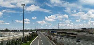
King's Highway 427 (pronounced "four twenty-seven"), also known as Highway 427 and colloquially as the 427, is a 400-series highway in the Canadian province of Ontario that connects the Queen Elizabeth Way (QEW) and Gardiner Expressway with York Regional Road 7 (formerly Highway 7) via Highway 401. An arterial extension, known as York Regional Road 99, continues 800 metres (2,600 ft) north to Zenway Boulevard. It is Ontario's second busiest freeway by volume and third busiest in North America, behind Highway 401 and Interstate 405 in California.[1][3] Like Highway 401, a portion of the route is divided into a collector-express system with twelve to fourteen continuous lanes. Notable about Highway 427 are its several multi-level interchanges; the junctions with QEW and Highway 401 are two of the largest interchanges in Ontario and were constructed between 1967 and 1971, while the interchanges with Highway 409 and Highway 407 are more recent and were completed in 1992 and 1995, respectively.
Highway 427 is the main feeder to Toronto Pearson International Airport from the north and south. However, while much of the traffic comes from Highway 407, Highway 401 (eastbound), and the QEW / Gardiner Expressway makes use of the freeway for airport access, it serves the western portion of Toronto (Etobicoke), the northeastern portion of Mississauga (Malton), the southeastern portion of Brampton (Claireville), and the western portion of Vaughan (Woodbridge). The section between Highway 401 and Dundas Street is a heavily traversed transit corridor; GO Transit, MiWay, and the Toronto Transit Commission (TTC) all operate express buses along this section of the highway.
First designated in 1972, Highway 427 follows what was originally a two lane roadway known as Highway 27, as well as a short freeway north of Highway 401 known as the Airport Expressway. Both routes were upgraded throughout the 1950s and 1960s, eventually becoming intertwined into the present configuration in 1972. The freeway was extended north from Pearson Airport to Highway 7 over the following twenty years. A short arterial extension was later built, though this section is designated as York Regional Road 99 (Zenway Boulevard). Plans have been announced to extend Highway 427 north to Major Mackenzie Drive; construction will begin in 2017 and is expected to be completed by 2020.[4]
Route description

Highway 427 is the second busiest freeway in Canada with an average of 300,000 vehicles that use it between the QEW and Highway 401 per day. The section between Burnhamthorpe Road and Rathburn Road has an annual average daily traffic (AADT) count of 353,100. The route is 19.9 km (12.4 mi) long.[1]
At its southern terminus, the route begins at Coules Court, where Brown's Line becomes Highway 427.[1] Alderwood Plaza, located on the east side of the route, has a parking lot which provides access to the highway; this is the only at-grade access along the length of the route.[5] The four lane road splits into a divided highway and descends below Evans Avenue. The highway weaves through a complicated interchange, providing northbound access to Evans Avenue and the Gardiner Expressway, and southbound access to The Queensway, QEW / Gardiner Expressway, and Evans Avenue. North of the interchange, the lanes from Brown's Line diverge and form the collector lanes of a collector-express system. Flyover ramps to and from the QEW / Gardiner pass over the southbound lanes and converge to form the express lanes. This collector-express system serves to divide local traffic from freeway-to-freeway traffic; the express lanes provide access between the QEW / Gardiner Expressway and Highway 401, while the collector lanes provide local access between those interchanges.[6]

After crossing Canadian Pacific Railway (CPR) tracks, the freeway interchanges with Dundas Street. A set of criss-crossing ramps provide access between the collector and express lanes north of here,[6] referred to as The Basketweave. The highway passes beneath Bloor Street West but does not provide direct access. Instead, it provides ramps to parallel arterial roads; The East Mall and The West Mall run parallel with the freeway from Evans Avenue to Rathburn Road.[5] A full interchange is provided shortly after with Burnhamthorpe Road, southwest of Burnhamthorpe Collegiate Institute. Across from the college, an offramp provides access from the southbound lanes to Holiday Drive and The West Mall. Following the offramp, to the north, is a partial interchange with Rathburn Road, which provides access from the northbound lanes and to the southbound lanes.[6]
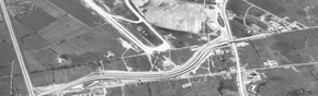
Transfers provide a second and final opportunity to cross between express and collector lanes, or vice versa, south of the complicated 1.56-square-kilometre (0.60 sq mi) Highway 401 interchange. A final set of ramps along the collector-express system provides access to and from the southbound lanes and Eringate Drive, after which the collectors diverge, and the express lanes cross the southbound collectors. The collector lanes provide access to and from Eglinton Avenue then transition into Highway 27, while the express lanes interchange with Highway 401 and continues the route of Highway 427 north. The Highway 427 express lanes and flyover ramps to/from Highway 401 are constructed around the Richview Memorial Cemetery.[6][7] Highway 427 passes through the sprawling interchange and becomes displaced approximately 1 km (0.62 mi) to the west. Despite its size, there are no ramps to provide access from southbound Highway 427 to eastbound Highway 401 and vice versa, as this connection is handled by Highway 409.[5] Highway 427 crosses Renforth Drive and then curves to the east of Runway 24R and 24L of Pearson Airport.[8] Shortly thereafter, it crosses and interchanges with Dixon Road and Airport Road, between which it forms the demarcation line.[6] Several ramps diverge at this point to provide access to Pearson Airport, and the freeway narrows to eight lanes.[5]
From here to Finch Avenue, the freeway follows the boundary line between Toronto and Mississauga.[6] It encounters the third multi-level junction along its length, with Highway 409, which provides access to the airport as well as the southbound to eastbound movement that cannot be performed at the interchange with Highway 401 to the south.[5] Highway 427 continues straight north and narrows again to six lanes.[5] After crossing the Kitchener GO line, it passes west of Woodbine Racetrack and beneath Rexdale Boulevard, Morning Star Drive, and Finch Avenue West, the first and last interchange with the route. The freeway bends slightly eastward, diverging from the Mississauga–Toronto boundary, and crosses the West Humber River where it drains from Claireville Reservoir.[6] Approaching the fourth and final sprawling interchange, it crosses Steeles Avenue and enters Vaughan.[5] It passes beneath Highway 407 and crosses through an undeveloped area before terminating at its final interchange with Highway 7.[5][6] The mainline continues north as a four lane arterial road to Zenway Boulevard and is designated as York Regional Road 99.[1][6]
History

QEW to Highway 401
Although Highway 427 was not officially designated until 1972,[9] several sections of freeway were already in place prior to that date. The designation was applied following the completion of the interchanges at the QEW and Highway 401 as well as the expansion of the section between them into a collector-express system.[2]
Highway 27 was designated as a two lane road travelling north from Highway 2 (Lake Shore Boulevard) towards Barrie. As Toronto grew outwards following the annexation of various municipalities, the Ontario Department of Highways (DHO) began planning for a bypass of the city, aptly named the Toronto Bypass. A significant portion of this bypass was designed to be incorporated into the Transprovincial Highway, now Highway 401. The remainder was designed to follow the existing right-of-way of Highway 27 between the QEW and Richview Sideroad (now Eglinton Avenue).[10]
Construction of the Toronto Bypass began near Yonge Street in 1949 (along present-day Highway 401) and on the four-laning of Highway 27 in 1953.[11][12] The Highway 27 work involved the construction of two interchanges: a three-way stack at Highway 401 and a large cloverleaf at the QEW, the latter of which would become one of the worst bottlenecks in the province a decade after its completion, according to Minister of Transportation Charles MacNaughton.[13] By September 1956, it was possible to bypass Toronto entirely on the four lane divided highway composed of Highway 401 and Highway 27.[14][15] Highway 401 was extended to the west soon after,[16] but Highway 27 remained a two lane highway north of it.[17]
Airport Expressway 1964-1971
During the early 1960s, Toronto International Airport was expanded with the construction of the Aeroquay One terminal.[18] To serve the expected demand of the expansion, the DHO built a new four lane freeway north from Highway 401 at Renforth Drive. This new route, which roughly followed the same route as Highway 427 as far as Dixon/Airport Road, was known as the Toronto Airport Expressway and was opened on January 3, 1964.[19][20] It featured a connection with the western terminus of Richview Sideroad at the southern end of the interchange with Highway 401 as well as an interchange with Renforth Drive.[19]
Expansion

In 1963, it was announced by MacNaughton that Highway 401 would be widened from a four lane highway to a collector-express system, modelled after the Dan Ryan Expressway in Chicago.[15] Plans were soon developed to apply this model to the QEW between Highway 27 and Royal York Road and to Highway 27 between the QEW and Highway 401, and were unveiled to Etobicoke council on October 13, 1966.[21] Design work followed and was completed by May 1967.[22] This reconstruction once again involved the junctions with the QEW and Highway 401, which were reconfigured into complicated multi-level interchanges to permit free-flow movement; construction began in September 1968.[23] The widening of Highway 27 required the demolition and rebuilding of overpasses at Bloor Street, Burnhamthorpe Road and Rathburn Road constructed just over a decade earlier.[22]
The junction with the QEW was built over 48.5 ha (120 acres) and required the construction of 19 bridges and the equivalent of 42 km (26 mi) of two lane roadway.[23] The junction with Highway 401 sprawls over 156 ha (385 acres) and required the construction of 28 bridges and the equivalent of 46.6 km (29 mi) of two lane roadway, the largest interchange in Canada.[24] The former was opened to traffic on November 14, 1969,[25] while the latter required several more years of construction staging, fully opening on December 4, 1971 (though portions were opened in the weeks prior to that[26]), just prior to Highway 27's renumbering as Highway 427. The rest of the route was rebuilt prior to the completion of these interchanges.[2]

The completed project resulted in the creation of Highway 427 between the QEW and Dixon / Airport Road, north of which traffic was defaulted onto Indian Line. The entire Airport Expressway was removed to make way for the new interchange, but the new route still included direct access to the airport.[22][27]
Extensions beyond Highway 401

Ultimately, it was planned to extend Highway 427 north along Indian Line to the future Highway 407, where ramps would direct northbound traffic onto Highway 27.[22] An extension north of Dixon/Airport Road began in 1976 as part of the work to build Highway 409,[28] and it included the construction of the interchange between the two freeways. By the beginning of 1980, this work was completed, and construction was progressing on the section north to Rexdale Boulevard, which opened by the end of the year.[29][30] In 1982, Construction began on the next section of Highway 427, which would extend it to Albion Road, north of the West Humber River.[31] This project included the extension of Finch Avenue west from Highway 27 to Steeles Avenue West and was completed in late 1984.[32]
As part of the initial phase of Highway 407, Highway 427 was extended north to Highway 7 in Vaughan and began with the construction of the interchange between the two in 1988.[33] With the interchange only half-completed, the extension was opened in late 1991.[34] By 1994, the final at-grade intersections—one at Morning Star Drive, and another as a left turn to the southbound lanes with eastbound Highway 409—were replaced, making Highway 427 a fully controlled-access freeway for its entire length.[35]
Future
An environmental assessment has been completed on a northward extension of Highway 427 to Major Mackenzie Drive to relieve traffic issues on Highway 7 and Highway 27, as well as provide improved access to the Canadian Pacific Intermodal Terminal.[36] A temporary arterial road extension was opened in the autumn of 2008 by York Region and designated as Regional Road 99. This road serves to provide improved access to Highway 27 and Highway 50, but will be removed when construction begins on the freeway extension.[36][37]
A section of Highway 427 between Campus Road-Fasken Drive and Steeles Avenue is being expanded to four lanes in each direction as of 2015. This project includes the installation of high-mast lighting, median barriers, and the addition of a High-occupancy toll (HOT) lane in both directions, and is scheduled for completion in the autumn of 2017.[38] On March 3, 2016, the Ontario government approved the extension of Highway 427 north towards Major Mackenzie Drive, with construction scheduled to begin in 2017. The project will include HOT lanes as far north as Rutherford Road. The extension is scheduled to open in 2020, with the HOT lanes opening the following year.[39]
Exit list
The following table lists the major junctions along Highway 427, as noted by the Ministry of Transportation of Ontario.[1] All exits are unnumbered.
| Division | Location | km[1] | mi | Destinations | Notes | |
|---|---|---|---|---|---|---|
| Toronto | 0.0 | 0.0 | Coules Court | Southbound terminus of Highway 427 | ||
| 0.3 | 0.19 | Evans Avenue | No access to Gardiner Expressway from northbound entrance | |||
| 0.6 | 0.37 | Gardiner Expressway – downtown Toronto | Southbound exit and northbound entrance; other movements are directed to Evans Avenue | |||
| Sherway Gardens Road The Queensway | No northbound exit; no access to QEW from southbound entrance. | |||||
| 2.3 | 1.4 | Dundas Street | Formerly Highway 5; no access to QEW from southbound entrance | |||
| Gibbs Road | Northbound entrance only | |||||
| Valhalla Road | Northbound exit only | |||||
| Eva Road | Southbound exit and entrance | |||||
| 4.2 | 2.6 | Burnhamthorpe Road | ||||
| Holiday Drive | Southbound exit only | |||||
| 5.2 | 3.2 | Rathburn Road | Northbound exit and southbound entrance | |||
| Eringate Drive | Southbound entrance only; southbound exit accessible from Highway 27 and Eglinton Avenue | |||||
| 7.8 | 4.8 | Eglinton Avenue | No access to Highway 401 east from northbound entrance | |||
| Northbound exit and southbound entrance | ||||||
| Toronto–Peel boundary | Toronto–Mississauga boundary | 10.3 | 6.4 | Dixon Road | Northbound exit and southbound entrance, access to Toronto Pearson International Airport | |
| Fasken Drive | Northbound exit only | |||||
| 11.6 | 7.2 | Southbound access to eastbound 401 via Highway 409, access to Toronto Pearson International Airport | ||||
| 14.2 | 8.8 | Regional Road 5 (Derry Road) Rexdale Boulevard | ||||
| 16.0 | 9.9 | Regional Road 2 (Finch Avenue) Finch Avenue West | ||||
| York|Regional Municipality of York|York | Vaughan | 18.3 | 11.4 | |||
| 19.9 | 12.4 | Northbound exit and southbound entrance | ||||
| 1.000 mi = 1.609 km; 1.000 km = 0.621 mi | ||||||
References
Sources
- 1 2 3 4 5 6 7 Ministry of Transportation of Ontario (2010). "Annual Average Daily Traffic (AADT) counts". Government of Ontario. Retrieved June 29, 2015.
- 1 2 3 "Highway 27 Interchange Fully in Service". The Globe and Mail. Toronto. December 4, 1971. p. 5.
- ↑ Office of Highway Policy Information (July 27, 2010). "Most Travelled Urban Highways Average Annual Daily Traffic (AADT) > 250,000". Federal Highway Administration. Retrieved June 30, 2014.
- ↑ Searle, Patrick; Nichols, Bob (March 3, 2016). "Ontario Moving Forward on Highway 427 Extension" (Press release). Ministry of Transportation of Ontario. Retrieved August 27, 2016.
- 1 2 3 4 5 6 7 8 Google (November 7, 2011). "Highway 427 length and route" (Map). Google Maps. Google. Retrieved November 7, 2011.
- 1 2 3 4 5 6 7 8 9 MapArt (2011). Golden Horseshoe (Map). Peter Heiler Ltd. pp. 101, 107, 113, 118, 353. § A2–T5, X–Z3. ISBN 978-1-55198-877-1.
- ↑ Bradburn, Jamie (October 29, 2012). "Toronto Cemetery Sojourns: Richview Memorial Cemetery". Torontoist. Retrieved June 13, 2015.
- ↑ "Aviation Investigation Report: A01O0299". Greater Toronto Airport Authority. 2001. Appendix A. Retrieved November 7, 2011.
- ↑ Sewell 2009, p. 70.
- ↑ "Speed Limit In Ontario Now At 60". The Ottawa Citizen. May 29, 1959. p. 23. Retrieved March 25, 2010.
- ↑ Sewell 2009, p. 63.
- ↑ Clarke, W.A (March 31, 1954). "Report of the Chief Engineer". Annual Report (Report). Department of Highways. p. 12.
- ↑ "Six-Mile Stretch of Highway 27 Will Be Expanded to Six Lanes". The Globe and Mail. Toronto. May 4, 1965. p. 5.
- ↑ '401' The Macdonald–Cartier Freeway. Ministry of Transportation and Communications. 1972. p. 8.
- 1 2 Shragge & Bagnato 1984, p. 94.
- ↑ Ministry of Transportation and Communications (November 3, 1958). Hwy. 10 to Hwy 27. (Toronto) 6.60. Ministry of Transportation and Communications. pp. 8–9.
- ↑ Department of Highways (1956). Ontario Road Map (Map). Cartography by C.P. Robins. Government of Ontario. § E30–F33.
- ↑ Lostracco, Marc (October 12, 2006). "Torontoist Remembers: Aeroquay One". Torontoist. Ink Truck Media. Retrieved January 9, 2012.
- 1 2 Annual Report (Report). Department of Highways. March 31, 1964. p. 108.
- ↑ "Chronology". Annual Report (Report). Department of Highways. March 31, 1965. p. 302.
- ↑ "Chronology". Annual Report (Report). Department of Highways. March 31, 1967. p. 315.
- 1 2 3 4 Planning Branch (May 1967). Functional Planning Report: Highway 27 Reconstruction from Dundas Street to Rexdale Boulevard and Proposed Belfield Expressway from Islington Avenue to New Highway 27 (Report). Ontario Department of Highways.
- 1 2 "Drivers Face Three More Years of QE-27-401 Motoring Misery". The Toronto Star. July 22, 1969. p. 43.
- ↑ "A New Maze in the Making for Motorists". The Globe and Mail. Toronto. November 20, 1969. p. 43.
- ↑ "QE and 27 Interchange Opens Friday". The Toronto Star. November 13, 1969. p. 1.
- ↑ "2 Ramps Opened at 27-401". The Toronto Star. November 24, 1971. p. 1.
- ↑ Ministry of Transportation and Communications (1973). Ontario Road Map (Map). Cartography by Photogrammetry Office. Government of Ontario. Metropolitan Toronto inset.
- ↑ Construction Program (Report). Ministry of Transportation and Communications. 1976–77. p. XIV.
- ↑ Construction Program (Report). Ministry of Transportation and Communications. 1980–81. p. XIX.
- ↑ Ministry of Transportation and Communications (1980–81). Ontario Road Map (Map). Cartography by Cartography Section. Government of Ontario. Metropolitan Toronto inset.
- ↑ Provincial Highways Construction Projects (Report). Ministry of Transportation and Communications. 1983–84. p. XIII. ISSN 0714-1149.
- ↑ Provincial Highways Construction Projects (Report). Ministry of Transportation and Communications. 1984–85. p. XIII. ISSN 0714-1149.
- ↑ Provincial Highways Construction Projects (Report). Ministry of Transportation. 1989–90. p. 13. ISSN 0714-1149.
- ↑ Provincial Highways Construction Projects (Report). Ministry of Transportation. 1991–92. p. 13. ISSN 0714-1149.
- ↑ Ministry of Transportation (1994–95). Ontario Road Map (Map). Cartography by Cartographic Mapping Unit. Government of Ontario. Metropolitan Toronto inset.
- 1 2 Rea, Bill (April 23, 2008). "MTO Just Looking North to Major Mack For 427 Extension". King Township Sentinel. King City, Ontario. Archived from the original on June 11, 2015. Retrieved January 9, 2012.
- ↑ Highway 427 Transportation Corridor Environmental Assessment Final Report (PDF) (Report). Ministry of Transportation of Ontario. January 29, 2010. Retrieved January 9, 2012.
- ↑ Searle, Patrick; Woozageer, Ajay (August 26, 2014). "Improvements Begin on Highway 427" (Press release). Ministry of Transportation of Ontario. Retrieved September 3, 2014.
- ↑ Searle, Patrick; Nichols, Bob (March 3, 2016). "Ontario Moving Forward on Highway 427 Expansion" (Press release). Ministry of Transportation of Ontario. Retrieved March 8, 2016.
Bibliography
- Sewell, John (2009). The shape of the suburbs: understanding Toronto's sprawl. University of Toronto Press. ISBN 978-0-8020-9587-9. Retrieved April 15, 2010.
- Shragge, John; Bagnato, Sharon (1984). From Footpaths to Freeways. Ontario Ministry of Transportation and Communications, Historical Committee. ISBN 0-7743-9388-2.
External links
| Wikimedia Commons has media related to Ontario Highway 427. |
- Highway 427 Corridor Environmental Assessment
- Lost Road: Indian Line Road
- Highway 427 pictures and information