Cootes Drive
| Cootes Drive | |
|---|---|
| Highway 8D, Highway 102 | |
| Route information | |
| Length: |
3.5 km (2.2 mi) (1963) |
| Existed: | 1936 (as Highway 8D) – 1964 (as Highway 102) |
| Major junctions | |
| West end: | York Boulevard |
| East end: |
|
| Location | |
| Major cities: | Hamilton, Ontario |
| Highway system | |
| Roads in Ontario | |
Cootes Drive, formerly known as the Dundas Diversion, is a city street in Hamilton, Ontario. The route connects York Boulevard and King Street in Dundas with Highway 2 and Highway 8 to the southeast, and is considered the first divided highway in Canada.
Route description

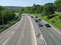
Cootes Drive travels from the former town Dundas, where it feeds into King Street at York Road. It travels through Cootes Paradise and past McMaster University to Main Street West (former Highway 2 and Highway 8)
There is a shared pedestrian and bicycle path along its length, and GO Transit operate two regional coach routes from their McMaster University GO Bus Terminal on the east side of Cootes Drive, at the edge of the university’s campus.
History
The Dundas Diversion was the first divided dual-carriageway road built in Canada; completed in 1936,[1] it predates the nearby Queen Elizabeth Way, which was still under construction at the time, with the name of ‘Middle Road’.
Cootes Drive is now signed as Hamilton Road 8. It was originally designated 8D (indicating that it was a diversion of Highway 8), then changed to the designation of Highway 102 in 1947, before being turned back to local authorities in 1964. The Highway 102 designation has since been reused on a different highway near Thunder Bay.
Major intersections
The following table lists the major junctions along Cootes Drive, as noted by the City of Hamilton. The entire route is located in Hamilton, Ontario.
| km | mi | Destinations | Notes | ||
|---|---|---|---|---|---|
| 0.0 | 0.0 | York Road | continues west as King Street | ||
| 0.5 | 0.31 | Dundas Street | Formerly Highway 99 and The Governors | ||
| 1.2 | 0.75 | Olympic Drive | |||
| 2.5 | 1.6 | Westaway Road | Access to McMaster University | ||
| 3.1 | 1.9 | Road 8 (Main Street West) | Continues south as Leland Street; formerly Highway 2 and Highway 8 | ||
| 1.000 mi = 1.609 km; 1.000 km = 0.621 mi | |||||