Garrett Park, Maryland
| Garrett Park, Maryland | |
|---|---|
| Town | |
|
Aerial view of Garrett Park, Maryland, in January 2007. | |
 | |
| Coordinates: 39°2′7″N 77°5′33″W / 39.03528°N 77.09250°W | |
| Country |
|
| State |
|
| County |
|
| Area[1] | |
| • Total | 0.26 sq mi (0.67 km2) |
| • Land | 0.26 sq mi (0.67 km2) |
| • Water | 0 sq mi (0 km2) |
| Elevation | 285 ft (87 m) |
| Population (2010)[2] | |
| • Total | 992 |
| • Estimate (2012[3]) | 1,022 |
| • Density | 3,815.4/sq mi (1,473.1/km2) |
| Time zone | Eastern (EST) (UTC-5) |
| • Summer (DST) | EDT (UTC-4) |
| ZIP code | 20896 |
| Area code(s) | 301 |
| FIPS code | 24-31525 |
| GNIS feature ID | 0584560 |

Garrett Park is a town in Montgomery County, Maryland. It was named for a former president of the Baltimore and Ohio Railroad, Robert W. Garrett. The population was 992 at the 2010 census. Garrett Park is home to Garrett Park Elementary School, just outside the town proper.
History

Garrett Park was incorporated as a town in 1898, with sponsorship by the Baltimore and Ohio Railroad, which in 1893 built a train station there.[4] The town lies along the former B&O railway corridor (now used by CSX, Amtrak, MARC) and was named for Robert W. Garrett, a former President of the B&O. It was a planned community from the beginning - when the land it was built on was purchased by a businessman named Henry W. Copp in 1886, he intended to build a suburban development reminiscent of an English village. Copp even went so far as to name the streets after locations in the novels of the English author Walter Scott, such as Kenilworth and Strathmore. He also limited commercial development, and even today there is only one store in the town. Builders were given reduced rates to transport workers and materials to the town site, and new residents were given free trips to move in. Rail suburbs did not catch on in the area, however, and the community stagnated somewhat as automobiles replaced trains and streetcars as the primary means of commuting. In the 1920s, another company built approximately 50 more houses, these with garages.[5] Much of the town is included in the Garrett Park Historic District, listed on the National Register of Historic Places in 1975.[6] Garrett Park Elementary School, designed in 1928 by prominent local architect Howard Wright Cutler, has been designated as an historic site by the Maryland Historical Trust.[7]
In May 1982 the townspeople of Garrett Park voted 245 to 46 to ban the production, transportation, storage, processing, disposal, or use of nuclear weapons within the town. This made Garrett Park the first nuclear-weapons free zone in the United States.[8]
Geography

Garrett Park is located at 39°2' North, 77°6' West. It is just west of Kensington, due north of Bethesda, northwest of Silver Spring, and southeast of Rockville. It is approximately halfway between Rockville and Silver Spring. Rock Creek Park is located along the town's southeast borders.
Its land area is 0.2 square miles (0.52 km2). According to the United States Census Bureau, the town has a total area of 0.26 square miles (0.67 km2), all of it land.[1]
Garrett Park is primarily a residential town, with a post office, and a few small businesses. The only road open to automotive traffic into or out of Garrett Park is Maryland State Highway 547 (Strathmore Avenue). The town is served by the MARC Train Brunswick Line. The town is unusual in that residents pick up their mail at the post office in person, rather than having home delivery.
Demographics
| Historical population | |||
|---|---|---|---|
| Census | Pop. | %± | |
| 1900 | 175 | — | |
| 1910 | 185 | 5.7% | |
| 1920 | 159 | −14.1% | |
| 1930 | 295 | 85.5% | |
| 1940 | 406 | 37.6% | |
| 1950 | 524 | 29.1% | |
| 1960 | 965 | 84.2% | |
| 1970 | 1,276 | 32.2% | |
| 1980 | 1,178 | −7.7% | |
| 1990 | 884 | −25.0% | |
| 2000 | 917 | 3.7% | |
| 2010 | 992 | 8.2% | |
| Est. 2015 | 1,044 | [9] | 5.2% |
2010 census
As of the census[2] of 2010, there were 992 people, 380 households, and 277 families residing in the town. The population density was 3,815.4 inhabitants per square mile (1,473.1/km2). There were 401 housing units at an average density of 1,542.3 per square mile (595.5/km2). The racial makeup of the town was 91.6% White, 1.3% African American, 0.2% Native American, 3.6% Asian, 0.4% from other races, and 2.8% from two or more races. Hispanic or Latino of any race were 5.5% of the population.
There were 380 households of which 35.3% had children under the age of 18 living with them, 61.3% were married couples living together, 8.9% had a female householder with no husband present, 2.6% had a male householder with no wife present, and 27.1% were non-families. 20.5% of all households were made up of individuals and 10.8% had someone living alone who was 65 years of age or older. The average household size was 2.61 and the average family size was 3.05.
The median age in the town was 46.8 years. 25.5% of residents were under the age of 18; 5.1% were between the ages of 18 and 24; 16.5% were from 25 to 44; 34.8% were from 45 to 64; and 18.2% were 65 years of age or older. The gender makeup of the town was 48.0% male and 52.0% female.
2000 census
As of the census[11] of 2000, there were 917 people, 347 households, and 266 families residing in the town. The population density was 3,427.8 people per square mile (1,311.3/km²). There were 356 housing units at an average density of 1,330.8 per square mile (509.1/km²). The racial makeup of the town was 91.82% White, 0.87% Black or African American, 0.22% Native American, 3.05% Asian, 1.53% from other races, and 2.51% from two or more races. 2.51% of the population were Hispanic or Latino of any race.
There were 347 households out of which 35.4% had children under the age of 18 living with them, 68.0% were married couples living together, 6.9% had a female householder with no husband present, and 23.3% were non-families. 18.2% of all households were made up of individuals and 8.9% had someone living alone who was 65 years of age or older. The average household size was 2.64 and the average family size was 3.02.
In the town the population was spread out with 25.4% under the age of 18, 3.1% from 18 to 24, 21.6% from 25 to 44, 31.7% from 45 to 64, and 18.2% who were 65 years of age or older. The median age was 45 years. For every 100 females there were 91.8 males. For every 100 females age 18 and over, there were 85.9 males.
The median income for a household in the town was $106,883, and the median income for a family was $126,662. Males had a median income of $96,588 versus $66,563 for females. The per capita income for the town was $50,305. None of the families and 0.8% of the population were living below the poverty line, including no under 18 and 2.6% of those over 64.
Law and government
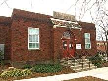
The Garrett Park Chapel was purchased by the town in 1968, and now serves as the Town Hall.
Mayor or City Executive
Recent Mayors of Garrett Park:
- Nancy M. Floreen (elected to the County Council of Montgomery County in the 2002 election)
- Peter Benjamin (2003–2004)
- Carolyn Shawaker (2005-2007)
- Chris Keller (2007-2012)
- Peter Benjamin (current)
Council
Garrett Park has a five-member council, elected for two-year terms.
Education
Garrett Park is served by the Montgomery County Public Schools.
Schools that serve the town include:
- Garrett Park Elementary School, in North Bethesda, adjacent to Garrett Park[12][13][14]
- Tilden Middle School
- Walter Johnson High School
The Washington Japanese Language School (WJLS, ワシントン日本語学校 Washington Nihongo Gakkō), a supplementary weekend Japanese school, has its school office at Quinn Hall of the Holy Cross Church in North Bethesda, adjacent to Garrett Park.[13][14][15] The WJLS holds its classes in Bethesda.[15][16] The institution, giving supplemental education to Japanese-speaking children in the Washington DC area, was founded in 1958,[17] making it the oldest Japanese government-sponsored supplementary school in the U.S.[18]
References
- 1 2 "US Gazetteer files 2010". United States Census Bureau. Retrieved 2013-01-25.
- 1 2 "American FactFinder". United States Census Bureau. Retrieved 2013-01-25.
- ↑ "Population Estimates". United States Census Bureau. Retrieved 2013-06-26.
- ↑ Garrett Park in 1898, Town of Garrett Park
- ↑ Offutt, William; Sween, Jane (1999). Montgomery County: Centuries of Change. American Historical Press. pp. 166–167.
- ↑ National Park Service (2008-04-15). "National Register Information System". National Register of Historic Places. National Park Service.
- ↑ Inventory of Historical Places, Maryland Historical Trust
- ↑ Schmidt, David (1991-06-29). Citizen Lawmakers. Temple University Press. p. 145. ISBN 978-0-87722-903-2.
- ↑ "Annual Estimates of the Resident Population for Incorporated Places: April 1, 2010 to July 1, 2015". Retrieved July 2, 2016.
- ↑ "Census of Population and Housing". Census.gov. Retrieved June 4, 2015.
- ↑ "American FactFinder". United States Census Bureau. Retrieved 2008-01-31.
- ↑ Home. Garrett Park Elementary School. Retrieved on April 30, 2014. "4810 Oxford Street, Kensington, MD 20895"
- 1 2 "Map" (Archive). Town of Garrett Park. Retrieved on April 30, 2014.
- 1 2 "2010 CENSUS - CENSUS BLOCK MAP: North Bethesda CDP, MD" (Archive). U.S. Census Bureau. Retrieved on April 30, 2014.
- 1 2 "Home" (Archive). Washington Japanese Language School. Retrieved on April 16, 2015. "学校事務局 Holy Cross Church, Quinn Hall 2F. 4900 Strathmore Avenue, Garrett Park, MD 20896[...]校舎 ストーンリッジ校 Stone Ridge School of the Sacred Heart 9101 Rockville Pike Bethesda, MD 20814"
- ↑ "SRMap2015.pdf." Washington Japanese Language School. Retrieved on April 16, 2015.
- ↑ "English." Washington Japanese Language School. Retrieved on April 30, 2014. "Washington Japanese Language School c/o Holy Cross Church, Quinn Hall, 4900 Strathmore Avenue, Garrett Park, MD 20896"
- ↑ "Andrew M. Saidel" (Archive). Japan-America Society of Greater Philadelphia (JASGP; フィラデルフィア日米協会とは). Retrieved on April 16, 2015.
External links
- Town of Garrett Park
- Garrett Park at the Maryland State Archives
- MARYLAND - Montgomery County - Historic Districts at the National Register of Historic Places
- "Seeing a Future Along Old Tracks" Sowers, Scott, Washington Post, July 8, 2006, Page F01
Coordinates: 39°02′07″N 77°05′33″W / 39.035276°N 77.092635°W
Municipalities and communities of Montgomery County, Maryland, United States | ||
|---|---|---|
| Cities | 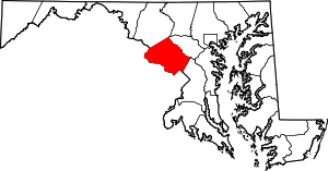 | |
| Towns | ||
| Villages & Special Tax Districts | ||
| CDPs |
| |
| Unincorporated communities | ||
| Footnotes | ‡This populated place also has portions in an adjacent county or counties | |