Ashton-Sandy Spring, Maryland
| Ashton-Sandy Spring, Maryland | |
|---|---|
| Census-designated place | |
|
Route 108 in Sandy Spring, Maryland, in November 2006. | |
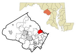 Location of Ashton-Sandy Spring, Maryland | |
| Coordinates: 39°8′54″N 76°59′55″W / 39.14833°N 76.99861°WCoordinates: 39°8′54″N 76°59′55″W / 39.14833°N 76.99861°W | |
| Country |
|
| State |
|
| County |
|
| Area | |
| • Total | 7.6 sq mi (19.7 km2) |
| • Land | 7.6 sq mi (19.6 km2) |
| • Water | 0.0 sq mi (0.1 km2) |
| Population (2010) | |
| • Total | 5,628 |
| • Density | 740.5/sq mi (287.1/km2) |
| Time zone | Eastern (EST) (UTC-5) |
| • Summer (DST) | EDT (UTC-4) |
| FIPS code | 24-02762 |

Ashton-Sandy Spring is a census-designated place (CDP) in Montgomery County, Maryland, United States. The CDP is designated to include the two unincorporated communities of Ashton and Sandy Spring.
Geography
Ashton-Sandy Spring is located at 39°8′54″N 76°59′55″W / 39.14833°N 76.99861°W (39.148270, -76.998599).[1]
According to the United States Census Bureau, the place has a total area of 7.6 square miles (20 km2), of which, 7.6 square miles (20 km2) of it is land and 0.04 square miles (0.10 km2) of it (0.26%) is water.
Demographics
As of census[2] 2010, there were 5,628 people, 1,839 households, and 1,434 families residing in the area. The population density was 740.5 people per square mile (287.1/km²). There were 1,936 housing units at an average density of 254.7/sq mi (98.8/km²). The racial makeup of the area was 71.7% White, 14.2% African American, 0.2% Native American, 8.3% Asian, 1.6% from other races, and 3.8% from two or more races. Hispanic or Latino of any race were 6.6% of the population.
There were 1,839 households out of which 35.9% had children under the age of 18 living with them, 66.6% were married couples living together, 8.5% had a female householder with no husband present, and 22.0% were non-families. 19.1% of all households were made up of individuals living alone and 12.3% had someone living alone who was 65 years of age or older. The average household size was 2.91 and the average family size was 3.34.
In the area the population was spread out with 25.3% under the age of 18, 6.3% from 18 to 24, 16.7% from 25 to 44, 32.9% from 45 to 64, and 18.8% who were 65 years of age or older. The median age was 46 years. For every 100 females there were 88.4 males. For every 100 females age 18 and over, there were 85.4 males.
A 2013 survey[2] estimated that the median household income in the area was $119,432, and the median income for a family was $163,403. Males had an estimated median income of $86,250 versus $94,861 for females. The estimated per capita income for the area was $62,468. The survey estimated about 6.9% of families and 7.2% of the population were below the poverty line, including 9.1% of those under age 18 and 9.7% of those age 65 or over.
References
- ↑ "US Gazetteer files: 2010, 2000, and 1990". United States Census Bureau. 2011-02-12. Retrieved 2011-04-23.
- 1 2 "American FactFinder". United States Census Bureau. Archived from the original on 2013-09-11. Retrieved 2015-03-03.
Municipalities and communities of Montgomery County, Maryland, United States | ||
|---|---|---|
| Cities | 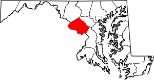 | |
| Towns | ||
| Villages & Special Tax Districts | ||
| CDPs |
| |
| Unincorporated communities | ||
| Footnotes | ‡This populated place also has portions in an adjacent county or counties | |