Cabin John, Maryland
| Cabin John, Maryland | |
|---|---|
| census-designated place | |
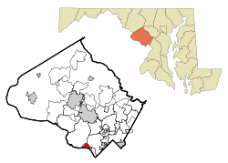 Location of Cabin John, Maryland | |
| Coordinates: 38°58′30″N 77°9′33″W / 38.97500°N 77.15917°WCoordinates: 38°58′30″N 77°9′33″W / 38.97500°N 77.15917°W | |
| Country |
|
| State |
|
| County |
|
| Area | |
| • Total | 1.3 sq mi (3.4 km2) |
| • Land | 1.0 sq mi (2.5 km2) |
| • Water | 0.3 sq mi (0.9 km2) |
| Elevation | 171 ft (52 m) |
| Population (2000) | |
| • Total | 1,734 |
| • Density | 1,762.4/sq mi (680.5/km2) |
| Time zone | Eastern (EST) (UTC-5) |
| • Summer (DST) | EDT (UTC-4) |
| ZIP code | 20818 |
| Area code(s) | 301 |
| FIPS code | 24-12075 |
| GNIS feature ID | 0589873 |
Cabin John is a census-designated place and an unincorporated area in Montgomery County, Maryland, United States.
Early land records in 1715 cite Captain John's Run, now Cabin John Creek. The toponym "Cabin John" is thought to be a corruption of the name "Captain John", but the origin of the name remains unresolved.[1]
Geography
As an unincorporated area, Cabin John's boundaries are not officially defined. Cabin John is, however, recognized by the United States Census Bureau as a census-designated place, and by the United States Geological Survey as a populated place located at 38°58′30″N 77°9′33″W / 38.97500°N 77.15917°W (38.975110, -77.159281).[2]
According to the United States Census Bureau, the place has a total area of 1.3 square miles (3.4 km2), of which, 1.0 square mile (2.6 km2) of it is land and 0.3 square miles (0.78 km2) of it (25.56%) is water.
Demographics
As of the census[3] of 2000, there were 1,734 people, 668 households, and 464 families residing in the area. The population density was 1,762.4 people per square mile (683.2/km²). There were 688 housing units at an average density of 699.3/sq mi (271.1/km²). The racial makeup of the area was 85.01% White, 3.63% African American, 0.23% Native American, 8.77% Asian, 0.46% from other races, and 1.90% from two or more races. Hispanic or Latino of any race were 2.71% of the population
There were 668 households out of which 36.2% had children under the age of 18 living with them, 60.9% were married couples living together, 5.7% had a female householder with no husband present, and 30.5% were non-families. 24.3% of all households were made up of individuals and 8.5% had someone living alone who was 65 years of age or older. The average household size was 2.60 and the average family size was 3.11.
In the area, the population was spread out with 25.8% under the age of 18, 4.7% from 18 to 24, 25.3% from 25 to 44, 34.9% from 45 to 64, and 9.3% who were 65 years of age or older. The median age was 42 years. For every 100 females there were 94.8 males. For every 100 females age 18 and over, there were 93.0 males.
The median income for a household in the area was $95,692, and the median income for a family was $125,493. Males had a median income of $84,112 versus $64,271 for females. The per capita income for the area was $52,401. None of the families and 2.4% of the population were living below the poverty line, including no under eighteens and 11.3% of those over 64.
See also
- Cabin John-Brookmont, a census-designated place delineated in 1980 and 1990
References
- ↑ Welles, Judith (2008). Cabin John: Legends and Life of an Uncommon Place. Cabin John, Maryland: Cabin John Citizens Association. ISBN 978-0-615-21117-6.
- ↑ "US Gazetteer files: 2010, 2000, and 1990". United States Census Bureau. 2011-02-12. Retrieved 2011-04-23.
- ↑ "American FactFinder". United States Census Bureau. Archived from the original on 2013-09-11. Retrieved 2008-01-31.
External links
- CabinJohn.org, a community website
Municipalities and communities of Montgomery County, Maryland, United States | ||
|---|---|---|
| Cities | 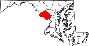 | |
| Towns | ||
| Villages & Special Tax Districts | ||
| CDPs |
| |
| Unincorporated communities | ||
| Footnotes | ‡This populated place also has portions in an adjacent county or counties | |