Floyd Bennett Field
|
Floyd Bennett Field Historic District | |
|
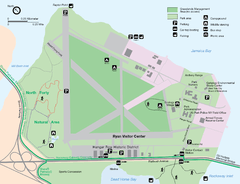
1998 map of Floyd Bennett Field from the National Park Service. | |
| Location | Marine Park, Brooklyn, New York City, United States |
|---|---|
| Built | 1928 |
| Architect | City Department of Docks |
| Architectural style | Classical Revival, Art Deco |
| NRHP Reference # | 80000363[1] |
| Added to NRHP | April 11, 1980 |
Floyd Bennett Field was New York City's first municipal airport, later a naval air station, and is now a park. While no longer used as an operational commercial, military or general aviation airfield, a section is still used as a helicopter base by the New York City Police Department (NYPD). Located in Marine Park, southeast Brooklyn, the field was created by connecting Barren Island and a number of smaller marsh islands to the mainland by filling the channels between them with sand pumped from the bottom of Jamaica Bay. The airport was named after famed aviator and Medal of Honor recipient Floyd Bennett, a Brooklyn resident at the time of his death. It was dedicated on June 26, 1930, and officially opened on May 23, 1931. The IATA airport code and FAA airfield identifier code was NOP when it was an operational naval air station and later coast guard air station, but now uses the FAA Location Identifier NY22 for the heliport operated there by the NYPD.
Since 1972, Floyd Bennett Field has been a part of Gateway National Recreation Area, managed by the National Park Service. Many of the earliest surviving original structures are included in a historic district listed on the National Register of Historic Places, being among the largest collections and best representatives of commercial aviation architecture from the period, and due to the significant contributions to civil aviation and military aviation made there during the Interwar period.
History
.jpg)
Prior to the opening of Floyd Bennett Field in 1930, a compacted dirt runway existed on the island. It was referred to as "Barren Island Airport", but was used primarily by one pilot who gave flights to paying customers.
The municipal airport site was chosen and designed by famed aviator Clarence D. Chamberlin. His preference was Barren Island, a 387-acre (1.57 km2) marsh with 33 small islands in Jamaica Bay, off the southeastern shore of Brooklyn. The site was favorable due to the lack of obstructions nearby, and because it was easily identifiable from the air. After much debate over the merits of other sites within the city (including Governors Island, the purported favorite of New York City mayor Fiorello LaGuardia), the Barren Island site was approved. Six million cubic yards of sand were pumped from Jamaica Bay to connect the islands and raise the site to 16 feet (4.9 m) above the high–tide mark. The new airfield's modern, electrically illuminated, concrete runways (when most "airports" still had dirt runways and no night landings) and comfortable terminal facilities with numerous amenities made it among the most advanced of its day, earning a rating of A-1 (the highest) by the United States Department of Commerce at the time. A seaplane base was constructed on the southern waterfront as part of the installation. Flatbush Avenue was widened and straightened to create a more direct route into Manhattan.
LaGuardia pushed for Floyd Bennett Field to replace Newark Airport in Newark, New Jersey as the city's de facto main air terminal, including designs and plans to shuttle passengers to and from Manhattan in flying boats. He was only able to persuade American Airlines to move its Newark operations to the new airport, and many passengers complained that ground travel from Bennett Field to Manhattan took longer than from Newark. In addition, particularly in the early days of commercial aviation, freight – not passengers – provided the bulk of profits. As airmail was a major fraction of air freight at the time, airports having contracts with the United States Post Office Department attracted commercial airlines. Airlines used the cargo area available on passenger aircraft to carry airmail, guaranteeing a profit on empty flights, and often providing more revenue than passenger ticket sales on under-booked flights, which were common. Public skepticism about the safety of this new form of transportation, as well as the Great Depression, made air travel an expensive luxury. As LaGuardia was never able to convince the Postal Service to move its New York City operations from Newark to Floyd Bennett Field,[2] neither did the airlines relocate. This hindered commercial air activities at the airfield. As a general aviation airfield, however, it attracted the record-breaking pilots of the interwar period because of its superior modern facilities and excellent location for flying, hosting dozens of "firsts" and time records as well as a number of air races in their heyday, such as the Bendix Cup.[3]
Notable aviators and flights
Famed aviator Wiley Post twice used the field for record-breaking 'round-the-world flights, and developed or adapted technology (such as the Sperry autopilot) there to aid him. Famous aviatrixes of the era, such as Jackie Cochran, Laura Ingalls, and even Amelia Earhart broke records at this airfield. Howard Hughes also used Floyd Bennett Field as the start and finish of his July 1938 record-setting circumnavigation of the globe in ninety-one hours (as depicted in the 2004 film The Aviator). Media-savvy pilot Roscoe Turner was also a frequent visitor at this airfield, often in conjunction with record-breaking flights.
Floyd Bennett Field's most storied flight was probably that of Douglas "Wrong Way" Corrigan who, in 1938, after repeatedly being denied permission by the authorities to attempt a non-stop flight to Ireland, "accidentally" crossed the Atlantic in a second-hand surplus aircraft on a flight registered to go to California. In the midst of the Great Depression a hero-starved nation hailed Corrigan for his "accident", even giving him a ticker-tape parade in Manhattan upon his return. (Irish authorities had his aircraft crated and sent him and his plane back to the USA on a ship.)
On July 16, 1957, then-Major John H. Glenn, Jr., USMC, established a transcontinental air speed record, flying an F8U-1P Crusader (BuNo 144608) from NAS Los Alamitos, California to NAS New York–Floyd Bennett Field, in 3 hours, 23 minutes, and 8.4 seconds. Project Bullet, as the mission was called, provided both the first transcontinental flight to average supersonic speed, and the first continuous transcontinental panoramic photograph of the United States. Glenn was awarded his fifth Distinguished Flying Cross for the mission.
Non-commercial activity

After the 1930s closure of Naval Air Station Rockaway across the inlet, a hangar at Floyd Bennett Field was dedicated as Naval Air Reserve Base New York within the larger civilian facility. The NYPD occupied a hangar for the world's first police aviation unit. At that time the fleet consisted of (fixed-wing aircraft; it later used only helicopters.
In addition, about 10 acres (40,000 m2) of Floyd Bennett Field along Jamaica Bay were leased by the city to the United States Coast Guard (USCG) in 1936, for the creation of Coast Guard Air Station Brooklyn (CGAS Brooklyn). During World War II, the civilian airfield was first leased and then sold to the United States Navy, which subsequently established Naval Air Station New York (NAS New York) to host several naval aviation units of the U.S. Atlantic Fleet, to include three land-based antisubmarine patrol squadrons, a scout observation service unit, and two Naval Air Transport Service (NATS) squadrons (processing the majority of the aircraft destined for the Pacific Theater), while still retaining the Coast Guard Air Station as a tenant.
The pilot Eddie August Schneider died in a training crash on the tarmac in 1940. NAS New York aircraft patrolled the Atlantic coastline and engaged German U-Boats, sustaining casualties, though this information was kept from the public at the time. In addition, Navy WAVES (Women Accepted for Volunteer Emergency Service) served as air traffic controllers in the control tower, directing traffic at the busy Naval Air Station, while others served as parachute riggers, packing parachutes and liferafts for use by aviators. Still others performed aircraft maintenance as Aviation Machinist's Mates, some of whom also served as "plane captains" for locally based aircraft.
Throughout the remainder of the postwar period and until the early 1970s, NAS New York-Floyd Bennett Field primarily functioned as a support base for units of the Naval Air Reserve and the Marine Air Reserve. CGAS Brooklyn continued to operate from NAS New York and the installation also served as a base for units of the New York Air National Guard from 1947 to 1970.
From the early 1980s to the early 1990s Floyd Bennett Field was homeport to a Naval combatant, the USS Boulder, LST-1190, as well as Naval Reserve Maintenance Facility (NRMTF)Brooklyn, a floating ship maintenance facility. In the early 1990s, the NRMTF function was transferred to SIMA Staten Island during the Navy's short stay in that location.
In the interim, commercial aviation in New York City moved to a new airport in Queens, which took advantage of the then-new Queens-Midtown Tunnel to Manhattan. That airport was quickly renamed LaGuardia Airport in recognition of that mayor's efforts to bring commercially viable aviation to New York City.
National Park Service acquisition
.jpg)
NAS New York was deactivated in 1971 and its tenant squadrons and personnel transferred to other naval air stations. An Armed Forces Reserve Center, which supported non-flying units remained, and is currently the airfield's only surviving military activity.
Most of the land transferred to the National Park Service (NPS) for inclusion in Gateway National Recreation Area. The majority of the remainder, constituting the area occupied by Coast Guard Air Station Brooklyn, was officially transferred to the Coast Guard and no longer leased.
CGAS Brooklyn was eventually decommissioned in 1998, following its merger with CGAS Cape May, New Jersey and relocation to the new Coast Guard Air Station Atlantic City, New Jersey. The majority of former Coast Guard land then transferred to the National Park Service (a small portion remained in the possession of the USCG parent agency at the time — the U.S. Department of Transportation — and a Doppler radar tower was placed there for use by nearby Kennedy International Airport). The NYPD moved their aviation operation from a historic hangar to the former Coast Guard Air Station facilities shortly afterward.
Current day
Normal usage
.jpg)

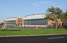
Volunteers from the Historic Aircraft Restoration Project maintain a collection of example aircraft of the type with historic connections to the airfield, and display them in the 1940s–era Hangar B.[4][5]
In addition, the airport's original Administration Building is partially accessible to the public, including (under escort) the former control tower. The runways have long since been closed, yet are occasionally reopened for fly-ins.
As the area of natural grasslands in the region has declined from its historic range due to urban sprawl (see: Hempstead Plains), the Grasslands Restoration And Management Project (GRAMP) was created to maintain the open grassland in the middle of the former airfield. The purpose is to compensate in a small way for the impact to the native flora and fauna that depend on such habitat lost on Long Island. The program is a joint venture of the National Park Service as the land management agency, and the Audubon Society.
The New York City Police Department (NYPD) has divisions located on the former airfield. The department's aviation base, with its fleet of Bell 412 and Agusta A119 Koala helicopters, is housed in space leased from the National Park Service that was once the United States Coast Guard Air Station Brooklyn, and is also now headquarters for the New York City Police Department Emergency Service Unit. The Driver Training Unit is also located there, using a section of former runway to teach officers to operate many different vehicles used by the department.
The New York City Department of Sanitation Training Center is located in Building 278 after its relocation from Randall's Island in January 2005.
The United States Park Police (USPP) operates out of the District 9 station, located on the former airfield, which is responsible for police coverage of the New York areas of the Gateway National Recreation Area.
In 2006, four of the eight original airport hangars were adapted for reuse and leased as a business concession for a community-based sports and entertainment complex. However, the historical integrity of some of the hangars has been alleged to be compromised thereby, in contradiction to the protections supposedly imposed by their inclusion on the National Register and under their management by the NPS.
The former airfield also accommodates public camping, with 46 campsites.[6] Floyd Bennett Field campground, however, is classified as primitive – with only portable toilets, and no electricity provided.[7] Still, it is the only public campground maintained by the National Park Service that is within the limits of an American city, and the only legal campground in New York City.[7] In 2011, Secretary of the Interior Ken Salazar announced that he wants Floyd Bennett Field to feature the largest urban campground in the United States – with 90 campsites by 2013, and the possibility of 600 total campsites sometime in the future.[8]
On July 21, 2011 U.S. Rep. Michael G. Grimm introduced H.R. 2606 – New York City Natural Gas Supply Enhancement Act. According to the bill's CRS Summary, "New York City Natural Gas Supply Enhancement Act – Authorizes the Secretary of the Interior to: (1) issue permits to allow the planning, construction, operation, and maintenance of natural gas pipeline facilities in the Gateway National Recreation Area (New Jersey-New York); and (2) enter into a lease agreement to allow the occupancy and use of an aircraft hangar building on Floyd Bennett Field (Brooklyn, New York) to house facilities associated with the operation of natural gas pipeline facilities. Requires rent proceeds and other fees generated in connection with such lease agreement to be deposited in a special account dedicated solely for use in the Gateway National Recreation Area".[9]
According to House Report 112-373, "Due to increased demand for natural gas in New York City, New York, additional pipeline capacity is needed. To remedy this problem, New York City is working to place a pipeline through Gateway National Recreation Area. H.R. 2606 provides the National Park Service (NPS) with the authority to approve a pipeline through its jurisdiction. As part of an agreement reached with NPS, in exchange for permitting the pipeline, the Williams Company will restore and maintain abandoned aircraft hangars in Floyd Bennett Field which is part of the Gateway National Recreation Area. One hangar will house the pipeline meter station and the others will be for park purposes".[10]
Other uses
- Since 1993, FBF has hosted a weekly bicycle racing series sponsored by Kissena Cycling Club that attracts cyclists from the Tri-state Area. The strong prevailing winds and rough pavement make the race challenging, yet it still brings racers to the airfield every Tuesday evening during the summer months.
- The Civil Air Patrol's Floyd Bennett Composite Squadron regularly meets at the former airfield.
- A small portion of the former airfield contains the only overnight campsite in a park within New York City: Ecology Village.[11] It is an environmental education program for students and specially trained teachers in cooperation with the New York City Department of Education. In the summer, the campgrounds are available on a permit basis for non-profit organizations and certified adult leaders.
- Since 1995, Floyd Bennett Field has often been the site of the annual Gateway to the Nations – New York City Native American Heritage Celebration organized by the Redhawk Native American Arts Council.
- The southern section of FBF is home to the 6th Communication Battalion of United States Marine Corps Reserve since July 1997.
- After the crash of American Airlines Flight 587 into Belle Harbor in the nearby Rockaway Peninsula on November 12, 2001, one of Floyd Bennett's hangars was used as a makeshift morgue for the crash victims.[12]
- Far from many of the brightest of nearby city lights, the former airfield offers among the best dark sky sites in the five boroughs. The Amateur Astronomers Association of New York meets there monthly from May to December for observing.
- Concorde G-BOAD was moved by agreement with the Aviator Sports concession to their entertainment complex on Floyd Bennett Field in December 2006[13] and was on display there for almost two years while the aircraft's regular home, the USS Intrepid, was moved out of its regular dock in Manhattan to be rehabilitated. Concorde's owner, British Airways, wished to see that their historic plane stay on public display in New York City until the Intrepid reopened.[14] The nose cone of the aircraft was knocked off by a truck during an event hosted by the sports center,[15] which cost Aviator a huge amount of money. The supersonic Concorde has no historic connection to the airfield.
- The New York Daily News reported on December 14, 2010,[16] that Andrew Murstein was considering a proposal to use the field as a site for a NASCAR track. Murstein is president of Medallion Financial Corp. which owns Richard Petty Motorsports.
- In the immediate aftermath of Hurricane Sandy (October 28, 2012 – November 15, 2012), a portion of the former runway was used as a staging area, by FEMA, for nearly 800 ambulances from all across the country responding to nearby Rockaway and other parts of Queens for rescues and evacuations.
Runways

- Runway 15–33: One of the original runways constructed in 1929, this 3,100-foot (940 m) x 100-foot (30 m) concrete runway was lengthened to 3,500 feet (1,100 m) in 1936. It was then modified to become the 4,500-foot (1,400 m) x 300-foot (91 m) taxiway T-10 in 1942. It runs parallel to the original hangars along Flatbush Avenue.
- Runway 6–24 (Old): The second of the original two runways constructed in 1929, this 4,000-foot (1,200 m) x 100-foot (30 m) concrete runway became taxiway T-1 and T-2 in 1942. It runs perpendicular to the original hangars along Flatbush Avenue, from the Administration Building/Control Tower to the more modern Hangar B.
- Runway 6–24 (New): Constructed in 1942, this 5,000-foot (1,500 m) x 300-foot (91 m) runway was lengthened to 6,000 feet (1,800 m) in 1952. It runs perpendicular to Flatbush Avenue on the North side of the field.
- Runway 1–19: Constructed in 1936, this 3,500-foot (1,100 m) x 150-foot (46 m) runway was lengthened to 5,000-foot (1,500 m) x 300 feet (91 m) in 1942. It was again lengthened to 7,000 feet (2,100 m) at an unknown date and was the longest runway at the airport. It runs from the vicinity of the current main public entrance to the field at the South end of Flatbush Avenue, to the North corner of the field near the Mill Basin inlet.
- Runway 12–30: Constructed in 1936, this 3,200-foot (980 m) x 150-foot (46 m) runway was lengthened to 5,000-foot (1,500 m) x 300 feet (91 m) in 1942. It was again lengthened to 5,500 feet (1,700 m) at an unknown date. It runs from the former Coast Guard Hangar to the Northwest corner of the field near Flatbush Avenue. For many years, the U.S. Coast Guard used 2,500 feet (760 m) of this runway for helicopter operations. Now the NYPD Aviation Unit uses this same segment.
Timeline
Some significant events at Floyd Bennett Field (FBF) during the Golden Age of Aviation:
- June 26, 1930 – Airport dedication. A crowd of 25,000 attended this aerial demonstration led by Charles Lindbergh and Jimmy Doolittle. A flotilla of 600 US Army Air Corps aircraft circled the field as part of the airport dedication. Admiral Byrd, Mayor Walker and his wife, and Mrs. Floyd Bennett were present at the dedication of the airport.
- July 28–30, 1931 – FBF to Istanbul, Turkey flight. Russell Norton Boardman (age 33) and John Louis Polando (age 29) flew a Bellanca Special J-300 high-wing monoplane named Cape Cod, (registration NR761W), powered by a 300 hp (220 kW) Wright J-6 Whirlwind engine, to Istanbul in 49:20 hours establishing a straight-line distance record of 5,011.8 miles (8,065.7 km), the first known non-stop, straight-line record flight whose distance surpassed either English (5,000 mi) or metric (8,000 km) mark. As the runway at FBF was just 5,000 feet (1,500 m) long, they needed to remove a fence and clear a parking lot to add another thousand feet to meet their required takeoff distance. The phone and electric utilities even took down poles along Flatbush Avenue.[17][18]
- July 28–29, 1931 – FBF to Moylegrove, Wales flight. Just 18 minutes after Boardman and Polando departed, Hugh Herndon Jr. and Clyde Pangborn flew a Red Bellanca CH-400 Skyrocket, named Miss Veedol (registration NR-796W) and powered by a 425 hp (317 kW) Pratt & Whitney Wasp engine, to Moylegrove, Wales in 31:42 hours. They stopped in Japan on their flight around the world and landed at FBF on October 17, 1931. The aircraft was later named "The American Nurse" and was lost in the Atlantic Ocean without a trace in 1932.
- June 3, 1932 – Failed transatlantic attempt. Stanislaus F. Hausner attempted a transatlantic flight from FBF to Warsaw, Poland, in a Bellanca CH Pacemaker, named Rose Marie and powered by a 300 hp (220 kW) Wright J-6 Whirlwind engine, and makes a forced landing at sea. He is rescued by a British tanker 8 days later.
- July 5–6, 1932 – Failed round-the-world attempt. James Mattern and Bennett Griffin flew a Lockheed Vega, powered by two Pratt & Whitney Wasp engines, from FBF to Harbor Grace, Newfoundland, and then nonstop to Berlin in 18:41 hours. They continued as far as Borisov, Russia in this failed round-the-world flight attempt.
- August 23 (or August 25) – September 11, 1932 – Failed transatlantic attempt. Colonel George R. Hutchinson and his family flew a Sikorsky amphibian, powered by two Pratt & Whitney engines, from FBF, but made a forced landing off the coast off Greenland. They were rescued two days later by a British trawler. In addition to the Colonel, his wife Blanche, daughters Kathryn and Janet Lee, a crew of five manned the aircraft.
- August 29, 1932 – Transcontinental record. James G. Haizlip flew a Weddell-Williams powered by a Pratt & Whitney Wasp Junior engine, from FBF to Los Angeles, California, in 10:19 hours, establishing a transcontinental record.
- August 29, 1932 – Failed transcontinental record. Roscoe Turner also flew a Weddell-Williams, powered by a Pratt & Whitney Wasp Junior engine, from FBF to Los Angeles, California, in 10:58:39 hours, but was beat by Haizlip.
- September 13, 1932 – Failed transatlantic attempt. William Ulbrich flew a Bellanca Skyrocket powered by a Pratt & Whitney Wasp engine, from FBF with passengers Dr. Leon Pisculli and Edna Newcomber. They were lost at sea.
- November 14, 1932 – Transcontinental record. Roscoe Turner flew a Weddell-Williams, powered by a Pratt & Whitney Wasp Junior engine, from FBF to Burbank, California, in 12:33 hours, establishing a new East–West record.
- June 2, 1933 – Transcontinental record. Lieutenant Commander Frank Hawks flew a Northrop Gamma, powered by a Wright Whirlwind engine, from Los Angeles, California to FBF, in 13:26:15 hours, establishing a new West–East non-stop record.
- June 11–12, 1933 – FBF to Haiti flight. Captain J. Errol Boyd, Robert G. Lyon, and Harold P. Davis flew a Bellanca monoplane, powered by a Wright Whirlwind engine, from FBF to Saint Marc, Haiti in about 24 hours.
- June 15, 1933 – Failed round-the-world attempt. James J. Mattern flew a Lockheed Vega, powered by two Pratt & Whitney Wasp engines, from FBF across the Atlantic, and makes a forced landing in Siberia. He later flew part of the way back to New York.
- July 1, 1933 – Transcontinental record. Colonel Roscoe Turner flew a Weddell-Williams, powered by a Pratt & Whitney Wasp Junior engine, from FBF to Los Angeles, California, in 11:30 hours, establishing a new East–West record.
- July 1 – August 12, 1933 – Balbo's transatlantic flight. Italian Air Force General Italo Balbo led a group of 25 Savoia-Marchetti S-55X seaplanes, powered by twin 750 hp (560 kW) Isotta-Fraschini Asso engines, from Orbetello, Italy, to Amsterdam, Iceland, Labrador, and Chicago. After two airplanes crashed along the journey, the group of 23 planes stopped at FBF for 6 days on their way back to Rome. The flight marked the 10th anniversary of Benito Mussolini's rise to power.
- July 15–17, 1933 – Transatlantic flight followed by a fatal crash. Captain Steponas Darius and Stasys Girėnas flew a Bellanca CH-300, named Lituanica and powered by a 300 hp (220 kW) Wright J-6 Whirlwind engine, from FBF to Soldin, Germany, (now Mysliborz in Poland) where they were killed in a crash. They were attempting a flight to Kaunas, Lithuania. This was the 7th transatlantic flight and 2nd in a total distance covered without landing.
- July 15–22, 1933 – Round-the-world flight. Wiley Post flew a Lockheed Vega (registration N-105W) named Winnie Mae, powered by a Pratt & Whitney Wasp engine, around the world in 7 days, 18:49:30 hours. He was the first to fly around the world solo. During that flight, he covered 15,596 miles (25,099 km) in 4 days, 19:36 hours, establishing a new record. A crowd on 50,000 people gathered at FBF to see him arrive.
- August 5–7, 1933 – FBF to Syria flight. Lt. Maurice Rossi and Paul Codos flew a Bleriot 110, powered by a Hispano Suiza engine, from FBF to Rayak, Syria in about 55 hours, and established a distance record of 5,657.4 miles (9,104.7 km).
- September 2, 1933 – Crash. Francisco de Pinedo was killed in a crash during takeoff from FBF.
- September 25, 1933 – West–East record flight. Colonel Roscoe Turner flew a Weddell-Williams, powered by a Pratt & Whitney Wasp Junior engine, from Burbank, California, to FBF, in 10:04:55 hours, establishing a new West–East record.
- February 28, 1934 – April 25, 1934 – South American flight. Laura H. Ingalls flew a Lockheed Air Express, powered by a Pratt & Whitney engine, from Glenn Curtiss Airport, North Beach, NY, on a 17,000-mile (27,000 km) tour of South America, including a solo flight across the Andes. She returned to FBF after the flight.
- May 14–15, 1934 – FBF to Rome flight. George R. Pond and Cesare Sabelli flew a Bellanca Pacemaker, named Leonardo da Vinci and powered by a 300 hp (220 kW) Wright J-6 Whirlwind engine, in an attempted non-stop flight from FBF to Rome, but were forced to land at Lahinch, Ireland, after 32:00 hours due to a fuel system problem. Later they flew to Rome. This was the 8th transatlantic flight.
- May 27–28, 1934 – Paris to FBF flight. Lt. Maurice Rossi and Paul Codos flew a Bleriot 110, powered by a Hispano Suiza engine, from Paris, France to FBF in 38:27 hours, the second non-stop flight from Europe to America. In August 1933, both men had flown from FBF to Rayak, Syria.
- September 1, 1934 – West–East record Flight. Colonel Roscoe Turner flew a Weddell-Williams, powered by a Pratt & Whitney Wasp Junior engine, from Burbank, California, to FBF, in 10:02:57 hours, beating his old record (September 25, 1933) by about 2 minutes, and establishing a new West–East record.
- January 15, 1935 – Passenger transport record flight. Major James H. Doolittle flew an "American Airlines Airplane Development" Vultee, powered by a Wright Cyclone engine, non-stop from Los Angeles, California, to FBF in 11:59 hours, and established a transcontinental non-stop record for a passenger transport airplane.
- February 20–21, 1935 – Passenger transport record flight. Leland S. Andrews also flew an American Airlines Airplane Development Vultee, powered by a Wright Cyclone engine, non-stop from Los Angeles, California, to FBF in 11:34:16 hours (beating Doolittle by almost a half-hour) and established a new transcontinental non-stop record for a passenger transport airplane.
- April 30, 1935 – Passenger transport record flight. D. W. Tomlinson flew a TWA Douglas DC-1, powered by twin Wright Cyclone engines, non-stop from Burbank, California, to FBF in 11:05:45 hours (beating Andrews by almost a half-hour).
- May 16–17, 1935 – Speed records. D. W. Tomlinson and J. S. Bartles flew the prototype Douglas DC-1, powered by twin Wright Cyclone engines, and established 14 speed records at FBF, demonstrating the increasing efficiency of transport planes and engines with heavy loads.
- May 18, 1935 – Speed records. D. W. Tomlinson and J. S. Bartles again flew the DC-1, and established 8 more speed records at FBF, further demonstrating the increasing efficiency of transport planes and engines with heavy loads.
- July 11, 1935 – Laura H. Ingalls flew a Lockheed Orion, powered by a Pratt & Whitney Wasp engine, from FBF to Burbank, California, establishing an East–West record for women.
- July 18 – August 16, 1935 – FBF to Norway flight. Thor Solberg flew a Leoning amphibian, powered by a Wright Cyclone engine, from FBF to Bergen, Norway, via Canada, Greenland, and Iceland.
- September 12, 1935 – Laura H. Ingalls flew a Lockheed Orion, powered by a Pratt & Whitney Wasp engine, from Burbank, California, to FBF, establishing a West–East record for women (return trip from her July 11, 1935 flight).
- September 21–22, 1935 – Attempted flight to Lithuania. Felix Waitkus (Feliksas Vaitkus) (1907–1956) flew a Lockheed Vega, powered by a Pratt & Whitney Wasp engine, from FBF to Ballinrobe, Ireland, on a projected flight to Lithuania.
- March 22, 1936 – The U.S. Postal Service rejected Floyd Bennett Field's application for the Air Terminal. This signals the failure of the field as a passenger airport as the airlines relied on the U.S. Mail contracts for revenue and would not schedule flights to FBF.
- April 21, 1936 – Miami to New York speed record. Howard Hughes flew a Northrop Gamma, powered by a Wright Cyclone engine, from Miami to FBF in 4:21:32, establishing an intercity speed record.
- September 2–3, 1936 – Attempted round-trip flight to London. Harry Richman and Richard T. Merrill flew an Airplane Development Vultee named Lady Peace, powered by a Wright Cyclone engine, from FBF to Llwyncelny, Wales, in 18:38 hours on an attempted round-trip flight to London, England.
- September 4, 1936 – East–West record flight. Louise Thaden and Blanche Noyes flew a Beechcraft, powered by a Wright Whirlwind engine, from FBF to Los Angeles, California, in 14:55:01, and established an East–West transcontinental speed record.
- October 6–7, 1936 – Attempted flight to Stockholm. Kurt Bjorkvall flew a Bellanca Pacemaker, powered by a Pratt & Whitney Wasp engine, in an attempted flight form FBF to Stockholm, Sweden. He was forced down in the Atlantic off the Irish coast.
- October 28–30, 1936 – Record non-stop flight to London. Captain James A. Mollison flew a Bellanca Flash, powered by a Pratt & Whitney Wasp engine, from FBF to Croydon Airport in London, England, not only making record time from Newfoundland, but was the first pilot to fly non-stop to London in 13:17 hours.
- December 14, 1936 – New York to Miami speed record. Major Alexander de Seversky flew a Seversky SEV-3, powered by a Wright Cyclone engine, from FBF to Miami, Florida, establishing a new speed record of 5:46:30 hours.
- December 17, 1936 – National Aviation Day – a celebration of the 33rd anniversary or the Wright Brothers first flight at Kitty Hawk.
- May 9–10, 1937 – Flight to London. Richard T. Merrill flew a Lockheed Model 10 Electra, powered by two Pratt & Whitney Wasp engines, from FBF to Croyden Airport in London, England, with a stop in Essex, in 20:59 hours.
- May 13–14, 1937 – Flight from London. Richard T. Merrill and John S. Lambie flew a Lockheed Electra Model 10 back from London to FBF, via Massachusetts, with photos of the coronation of George VI in 24:22:25 hours.[19]
- July 10–14, 1938 – Round-the-world flight. Howard Hughes flew a Lockheed 14N Super Electra (registration NX-18973), powered by two 900 hp (670 kW) Wright Cyclone engines, around the world in 3 days, 19:08:10 hours, testing new navigation equipment. A crowd of 25,000 people greeted his return.
- July 17–18, 1938 – The flight of "Wrong Way" Corrigan. Douglas Corrigan flew a Curtiss Robin, powered by a 165 hp (123 kW) Wright Whirlwind, J-6 engine, non-stop from FBF to Dublin, Ireland, in 28:13 hours. After being denied permission to make the flight to Ireland, he filed a flight plan to California, but then flew to Ireland. The 31-year-old pilot departed at 5:15 a.m. and claimed to have trouble with his compass and never admitted otherwise. Corrigan died on December 9, 1995 at age 88s.
- August 10–11, 1938 – Fw 200 lands at FBF. Alfred Henke, Rudolph von Moreau, Paul Dierberg, and Walter Kober, flew a prototype Focke-Wulf Fw 200 (registration D-ACON), named Brandenburg and powered by four Pratt and Whitney 875 hp (652 kW) Hornet engines, non-stop from Berlin, Germany, to FBF in a record time of 24:50:12 hours.
- August 13–14, 1938 – Fw 200 departs from FBF. Henke, von Moreau, Dierberg and Kober flew the same Focke-Wulf Fw 200 non-stop from FBF back to Berlin, in a record time of 19:55:01 hours, cutting the previous record of Wiley Post by 5:50 hours.
- December 3, 1938 – Women's West–East transcontinental record. Jacqueline Cochrane flew a Seversky, powered by two Pratt & Whitney Wasp engines, from Burbank, California, to FBF in 10:27:55 hours, setting the women's West–East transcontinental record.

- May 24, 1939 – Mexico City to FBF flight. Francisco Sarabia flew a Gee Bee Racer from Mexico City to FBF in 10:45 hours, beating the non-stop record flight time of 14:19 hours set by Amelia Earhart on May 8, 1935. Sarabia was killed in a crash minutes after departing on his return flight from Washington D.C. (June 7, 1939).
- October 15, 1939 – LaGuardia Airport dedicated. FBF's possibility of commercial success was doomed by the opening of this $45 million, 558-acre (2 km2) airport, located at the site of the old North Beach Airport. Almost 300,000 people attended the ceremony for the field, which was named for New York Mayor Fiorello LaGuardia.
In popular culture
- In the 1933 King Kong movie, the planes that attacked King Kong took off from Floyd Bennett field, though it was not specifically mentioned in the film.
- In his novel Netherland, Joseph O'Neill locates the site of the character Chuck Ramkissoon's proposed New York Cricket Club and ground at Floyd Bennett Field.[20] The character and events are based on reality.
- The field appears in the 2007 crime drama We Own The Night.
- The field is used as a makeshift headquarters for Delta Force in the video game Call of Duty: Modern Warfare 3.
- The airfield has an apparent cameo as a U.S. Police Force facility in the Gullfire takeoff scene from Escape from New York. The scene was actually shot at the now defunct Indian Dunes Airport in Valencia, California.
See also
References
- ↑ National Park Service (March 15, 2006). "National Register Information System". National Register of Historic Places. National Park Service.
- ↑ Even with the improved facilities, it was still quicker to move mail into the city from the New Jersey airfield than from Floyd Bennett field.
- ↑ Blakemore, 1981, p. 51.
- ↑ "Exploring Hangar B, Where Dying Airplanes Return To Life". Scouting New York. 17 May 2012. Retrieved 27 March 2015.
- ↑ "The Angels of HARP: Preserving, Researching and Restoring Aviation History". Gateway National Recreation Area. Retrieved 27 March 2015.
- ↑ "Camping at Gateway". National Park Service. Retrieved 2 September 2011.
- 1 2 Newman, Barry (13–14 August 2011). "A Campground Grows in Brooklyn, Bringing a New York Edge to Roughing It.". The Wall Street Journal. New York. pp. 1, A10. Retrieved 2 September 2011.
- ↑ "From Amelia Earhart to S'mores: New York City's First Airport to become Country's Largest Urban Campground". Mail Online. London. 14 June 2011. Retrieved 2 September 2011.
- ↑ "HR 2606". CRS Summary of HR 2606. Library of Congress. Retrieved 6 February 2012.
- ↑ "Background And Need For Legislation". House Report 112-373 – New York City Natural Gas Supply Enhancement Act. Library of Congress. Retrieved 6 February 2012.
- ↑ "Gateway NRA, Floyd Bennett Field: Ecology Village Camping Program" (PDF). National Park Service. Retrieved 6 September 2011.
- ↑ "FDNY Responds: Flight 587 Crashes in the Rockaways". NYC.gov. Retrieved 1 January 2007.
- ↑ "British Airways Concorde to Return to Hudson River Park's Pier 86 in Preparation for the Reopening" (Press release). The Intrepid Sea, Air & Space Museum. 20 October 2008.
- ↑ McGeehan, Patrick (5 November 2006). "Concorde to Travel to Brooklyn, but Not by Air". New York Times.
- ↑ McGeehan, Patrick (7 July 2008). "A Concorde Is Disfigured While Parked in Brooklyn". New York Times.
- ↑ Griffith, Carson; Fischer, Molly (14 December 2010). "Taxi tycoon Andrew Murstein is revved to build race track in New York, bring sport to fans". New York Daily News.
- ↑ "'Cape Cod's' Success Climaxes 5 Years [of] Bellanca Records". The Sunday Morning Star, Wilmington, DE. 2 August 1931. Retrieved 4 September 2013.
- ↑ "Airisms from the Four Winds - More Atlantic Flights". Flight. United Kingdom: flightglobal.com. July 31, 1931. p. 774. Retrieved February 23, 2016.
- ↑ "Transport: 21 Hours". Time. 17 May 1937.
- ↑ O'Neill, Joseph (2008). Netherland. Harper Perennial.
Sources
- Blakemore, Porter R. Historic structures report, Floyd Bennett Field, Gateway National Recreation Area. U.S. Dept. of the Interior, National Park Service, Denver Service Center, Mid-Atlantic/North Atlantic Team, Branch of Historic Preservation (1981), Volume 1 and Volume 2
- Delano, Michael P., Notable Flights at Floyd Bennett Field. U.S. Department of the Interior, National Park Service (1981) (Derived from Historic Structures Report).
- Scarino, Marianne Cannava, The Rise and Fall of Floyd Bennett Field, Air & Space/Smithsonian, June/July 1987, pp. 34–45.
External links
| Wikimedia Commons has media related to Floyd Bennett Field. |
- Floyd Bennett Field Visitor Information
- The Floyd Bennett Field Task Force
- Historic Floyd Bennett Field
- National Park Service: Floyd Bennett Field Historic District
- National Park Service: Gateway National Recreation Area
- Floyd Bennett Field: Naval Aviation's Home in Brooklyn, a National Park Service Teaching with Historic Places (TwHP) lesson plan
- Aviation: From Sand Dunes to Sonic Booms, a National Park Service Discover Our Shared Heritage Travel Itinerary
- United States Marine Corps: 6th Comm BN
- AirNav information for NY22: NYPD Air Operations Heliport (Floyd Bennett Field)
Coordinates: 40°35′28″N 73°53′28″W / 40.591°N 73.891°W
| |||||||||||||||||||||||||
| |||||||||||||||||||||||||
| |||||||||||||||||||||||||
| |||||||||||||||||||||||||