Brooklyn Bridge Park
| Brooklyn Bridge Park | |
|---|---|
|
View of Pier 1 with Manhattan and the Brooklyn Bridge in background | |
   | |
| Type | Urban park |
| Location |
334 Furman Street Brooklyn Heights, NY 11201 United States |
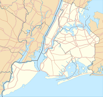
| Coordinates | 40°41′51″N 73°59′57″W / 40.69750°N 73.99917°WCoordinates: 40°41′51″N 73°59′57″W / 40.69750°N 73.99917°W |
| Area | 85-acre (34 ha) |
| Created | 2008–present |
| Designer | Michael Van Valkenburgh Associates, Inc. |
| Operated by | Brooklyn Bridge Park Corporation |
| Open | All year |
| Status | Partially open; unopened portion under construction |
| Website | www.BrooklynBridgePark.org |

Brooklyn Bridge Park is an 85-acre (34 ha) park on the Brooklyn side of the East River in New York City. The park has revitalized 1.3-mile (2.1 km) of Brooklyn's post-industrial waterfront from Atlantic Avenue in the south, under the Brooklyn Heights Promenade and past the Brooklyn Bridge, to Jay Street north of the Manhattan Bridge.[1] The site includes Brooklyn Piers 1–6, the historic Fulton Ferry Landing, and the preexisting Empire–Fulton Ferry and Main Street Parks. Two Civil War-era structures, Empire Stores and the Tobacco Warehouse, will also be integrated into the park.[1]
Brooklyn Bridge Park is overseen by Brooklyn Bridge Park Corporation, a not-for-profit entity responsible for the planning, construction, maintenance, and operation of the park. The Corporation's mission is to "create and maintain a world class park that is a recreational, environmental and cultural destination enjoyed by residents of, and visitors to, New York City".[2]
History

As a port
In 1642 the first ferry landing opened on the land that is now Brooklyn Bridge Park's Empire Fulton Ferry section. Soon after a thriving trading economy developed into a small town called "het Veer," meaning "the Ferry".[3] As het Veer grew throughout the 17th century, it became known as the "Road to the Ferry".[4]
On August 29, 1776, het Veer served as a crucial strategic location for George Washington and the Continental Army in the American Revolution's Battle of Long Island. In the middle of the night, George Washington and his men evaded the British Army, who were quickly gaining upon the Continental Army, by escaping across the East River to Manhattan.[5]
As the 18th century came to a close, additional ferry services were added to this waterfront community, including docking points for the "Catherine Street Ferry" and the first steamboat ferry landing that was created by Robert Fulton, which eventually became known as the Fulton Ferry Landing.[4] The community continued to grow into the 19th century as Brooklyn Heights developed into a residential neighborhood. By the 1850s, Brooklyn City Railroad rail lines were installed at the Fulton Ferry Landing.[4] During this boom period, brick warehouse development proliferated along the waterfront. In fact, the area soon became known as "the walled city".[4] In addition to the warehouses, the Empire Stores were constructed between 1870 and 1885.[6]
In 1883, the Brooklyn Bridge was opened after being constructed for 13 years.[7] While the Brooklyn Bridge formed a needed link between Manhattan and Brooklyn, it also disrupted ferry traffic. The Manhattan Bridge, developed in 1909, further disrupted trade to this section of the East River. The addition of these two crucial bridges resulted in the demise of this waterfront and the closing of the Fulton Ferry Landing in 1924.[4] Further disrupting the waterfront economy was the construction of the Brooklyn Heights Promenade and Brooklyn-Queens Expressway in 1950 and 1954, respectively.[4] These two developments effectively separated Brooklyn Heights from the waterfront.
Throughout the 1950s, over 130 warehouses and 25 finger piers were demolished along Brooklyn's waterfront. In order to accommodate larger ships and cargo, the New York Dock Company built 13 new piers between 1956 and 1964—this development includes Piers 1–3 and 5–6 of what is currently Brooklyn Bridge Park. Pier 2 was not developed until 1958.[4] However, as trade technology advanced, so did trade routes. By the 1970 much of the Brooklyn waterfront developments were largely barren and decrepit, causing the Port Authority to end cargo ship operations in 1983.[3] Many of these warehouses were demolished by the end of the 20th century. However, the warehouses on the piers comprising Brooklyn Bridge Park were not demolished until the park began its construction in 2008.[4] In 2011 Brooklyn Bridge Park won the Rudy Bruner Award for Urban Excellence silver medal.[8]
Conversion into park
Design

In 1984, shortly after closing cargo ship operations on this stretch of waterfront, the Port Authority decided to sell the vacant piers for commercial development.[9] In response to these plans, the not-for-profit organization Friends of Fulton Ferry Landing was established in 1985, conceiving the idea of Brooklyn Bridge Park.[9]
As the Friends of Fulton Ferry Landing grew, its name changed in 1989 to the Brooklyn Bridge Park Coalition, an organization dedicated to advocating for the park's creation, which is now known as the Brooklyn Bridge Park Conservancy.[10] With planning for the waterfront commencing, Brooklyn Borough President Howard Golden established the Brooklyn Waterfront Local Development Corporation (LDC) in 1998 to complete a year-long planning and visioning process for Brooklyn Bridge Park.[11] With $1 million in funding secured by New York State Senator Martin Connor and Assemblywoman Joan Millman, the LDC began an intense public outreach process—these efforts culminated in the Brooklyn Bridge Park Illustrative Master Plan, published in September 2000.[12]
On May 2, 2002 Mayor Michael Bloomberg and Governor George Pataki signed a Memorandum of Understanding (MOU) in which New York State and the City of New York agreed to create, develop, and operate Brooklyn Bridge Park on 85 acres of the East River waterfront, stretching from Atlantic Avenue to Jay Street.[13] The MOU also formed the Brooklyn Bridge Park Development Corporation (BBPDC) to develop the park, following the guidelines as established by the Illustrative Master Plan.[13] To begin the first-phase of construction, New York State, New York City, and the Port Authority of New York and New Jersey contributed a portion of the $360 million of capital funding for a complete park build out. To ensure the park is fiscally sustainable throughout the years, the MOU mandates that all maintenance and operations of the park are required to be economically self-sufficient, financed through revenues from commercial and residential development within the site.[13]
The first two phases of the Park, including the Main St, dog run, both beach portions and adjacent playgrounds were designed in house at the New York City Department of Parks.[14][15][16] In 2004, BBPDC hired Michael Van Valkenburgh Associates, Inc., a landscape architecture firm, to plan, design, and prepare a master plan for the full development of Brooklyn Bridge Park. Subsequently, the park's Master Plan was released in 2005 and the General Project Plan was approved in 2006 and then modified in 2010.[17] In 2011, a new MOU was signed, granting further funding for parkland construction and outlining the requirements for commercial and residential development.[18]
Construction

Park construction began on January 28, 2008.[19] The first 6 acres of park opened in March 2010 at Pier 1, including a waterfront promenade, lawns, a playground, and the Granite Prospect.[20] Later that summer nearly 12 acres of parkland opened on Pier 6 and the Pier 2 uplands, bringing diverse playgrounds, sand volleyball courts, concessionaires, and natural habitats to the park.[21]
After Piers 1 and 6 were opened to the public, a nonprofit corporation sharing a name with the park was established to continue parkland construction and plan for park maintenance and operation.[22] The Empire Fulton Ferry section, including this historic 1920 Jane's Carousel, re-opened in September 2011.[23]
Park sections

Brooklyn Bridge Park spans 85 acres of the East River waterfront in the Brooklyn Heights and Dumbo neighborhoods of Brooklyn. The park is divided into eleven sections: Piers 1 through 6; Fulton Ferry Landing; Brooklyn Bridge Plaza; Empire Fulton Ferry; Main Street; and John Street.[12] Each of these sections features unique topographies, plantings, amenities, and cultural artifacts and installations. All of the sections are currently open to the public; the Brooklyn–Queens Greenway, spanning the park, is also open.
Pier 1 and Fulton Ferry Landing
Pier 1 was the first section of parkland opened in March 2010.[20] The pier is Brooklyn Bridge Park's largest and is the only one constructed on a landfill, rather than a pile-supported structure. The area includes two landscaped lawns overlooking the Brooklyn Bridge and New York Harbor, a native salt marsh, a waterfront promenade, a granite prospect, a playground, and concessionaires.[24] Two development sites, slated to contain a 200-room hotel, 159 residential units, as well as restaurants and other public/private spaces, are located along Furman Street and are scheduled to open by Fall 2015.[25] The East River Ferry is also accessible on Pier 1.
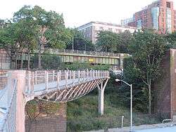
In addition to these features, Squibb Park Bridge, an award-winning, $4.9 million, 450-foot long pedestrian bridge constructed in Spring 2013, connects Brooklyn Heights' Squibb Park to Pier 1, creating a critical point of connectivity for the surrounding community.[26] The bridge was designed to be lightweight and flexible, providing a bouncy feeling to visitors. Renovations in and around Squibb Park Bridge are currently underway. The bridge was closed on August 11, 2014, with renovations seeking to strengthen the bridge's structural integrity, incorporate new material and finishes in Squibb Park, and replicate the existing furnishings to be consistent with the neighborhood's historic character. The original ramp has been re-graded in order to enable ADA access into the park. Newly installed lighting around the perimeter of the park allows the park to restore evening hours. The renovations are expected to be complete in Spring 2015.[27]
The Fulton Ferry Landing is directly adjacent to Pier 1. This small section of the park is the site of Brooklyn's first ferry landing, opened in 1642.[3] Re-opened to the public in 1997, Fulton Ferry Landing provides views of the Manhattan skyline, houses the classical music venue Bargemusic, and is home to the Brooklyn Ice Cream Factory. The New York Water Taxi is also accessible from the Landing.[28] Fulton Ferry Landing features custom-designed marine railings that interweaves Walt Whitman's famous "Crossing Brooklyn Ferry" poem with imagery evocative of the Brooklyn Bridge. Bronze relief drawings of local historic scenes are embedded in the pier deck.[29]
There are supposed to be housing units on the edge of the Pier 1 section of the park. Construction on these units, which are part of the Pierhouse residential complex, was stopped in January 2015 over a height dispute.[30] Opponents of the housing argue that the view of the Brooklyn Bridge from the Brooklyn Heights Promenade would be obstructed by the new structures. There have been height issues related to the building since 2005, when a draft environmental impact statement proposed, among other things, a 110 feet (34 m) residential building that was to replace some warehouses; the housing on the east side of the park is supposed to fund maintenance for the park itself. However, the impact statement was edited to make the Pierhouse only 100 feet (30 m) high. Construction of these units was stopped after Pierhouse's developers wanted to raise the building's roof by 3.5 feet (1 m). Regina Myer, president of the Brooklyn Bridge Park organization since 2007, said that since due to the Pierhouse's being narrower than the former warehouses, there is a greater view of the East River from the Promenade.[31]
Pier 2

A former warehouse dock, Pier 2 opened in May 2014 and is dedicated to active recreation. The Pier contains over five acres of basketball, handball, bocce, and shuffleboard courts, and over half an acre of artificial play turf, fitness equipment, swing sets, and picnic tables available for walk-up use. A wide promenade wraps around the pier, offering views of the Manhattan skyline and New York Harbor. Restrooms, lockers, water fountains/bottle refilling stations, and bike racks are also available. The Pier and all facilities are fully ADA accessible.[32] A warehouse roof preserved from when the pier was operated by the Port Authority of New York and New Jersey partially covers the pier. Additionally, Brooklyn Bridge Park Boathouse operates a free summer kayaking program, which lets patrons paddle in the protected embayment.[32]
Pier 3 Greenway Terrace
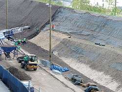
In November 2013, Brooklyn Bridge Park opened the Pier 3 Greenway Terrace, adding expansive lawns, a granite terrace and the first of the park's sound attenuating hills. The Pier 3 Greenway Terrace completes the continuous promenade that runs along the water's edge from Pier 1 to Pier 6.[33] The Granite Terrace features salvaged granite blocks that emerge from planted areas that rise 4 to 5 feet and include paintings of flowering trees and evergreens to provide a shady seating area. The granite was salvaged from reconstruction work on the Roosevelt Island Bridge and Willis Avenue Bridge. Working in partnership with the New York City Department of Parks and Recreation, Brooklyn Bridge Park received surplus granite from the bridge reconstruction projects, adding to the Park's sustainable features.[33]
Included in Pier 3 is the sound-attenuating hill that separates the stretch of park from the noisy Brooklyn-Queens Expressway cantilevered over Furman Street. To attenuate the noise, the park's design includes 20- to 30-foot high hills between Piers 2–5. This hill runs along the entire length of the Greenway Terrace and reduces noise pollution in the park up to 75 percent, from 75 decibels to 68 decibels.[34] This hill is formed by salvaged material from the Metropolitan Transportation Authority's East Side Access project in Midtown Manhattan.[35]
Dahn Vo: We the People, a public art installation inspired by the Statue of Liberty, was on display on Pier 3 from May to December 2014. The sculpture was a copper replica of the statue in 250 parts fabricated over the course of four years using the original techniques and materials. Visitors to Brooklyn Bridge Park saw a replica of the draped sleeve of the statue's arm which holds the golden torch.[36]
On October 20, 2016, construction started on the Pier 3 section of the park. Pier 3, which comprises the section of the park that includes Pier 3 Greenway Terrace, is going to be 5 acres (2.0 ha) in area. It will open in spring 2018.[37][38]
Pier 4 Beach
Built from the remnant of a railroad float transfer bridge that has settled on the river bed, Pier 4 is planted with native species to assist its ongoing evolution as a protected habitat preserve. The beach design incorporates structures designed by ECOncrete to mimic natural tidal pools typically found along rocky coasts. Some of these pools are accessible to visitors. Non-motorized boats can also be launched from the site. Seven tide pools were installed at the beach for the study of marine life.[39]
Offshore from the beach is Bird Island, an inaccessible nature preserve built from the remnants of a railroad float transfer bridge. Bird Island is planted with a variety of salt-tolerant shrubs, grasses, and trees to encourage the growth of a diverse ecology. The island also features three ECOncrete tide pools as an added ecological element. An Osprey platform has been installed to attract large fishing birds. Rip rap stones surround the edge of the island to buffer the beach.[39]
Pier 5


On December 13, 2012, Pier 5 officially opened.[40] Pier 5 consists of three athletic fields, two playgrounds and a picnic area, costing $26 million to develop the 5 acre site.[40] The athletic fields are made of synthetic turf and will predominantly be used for soccer and can also accommodate lacrosse, cricket, rugby and ultimate Frisbee. The fields will be available for youth and adult leagues, as well as for private and public schools. St. Francis College will host its Division I men's soccer home games at Pier 5 beginning in 2013.[41] The first Division I game at Pier 5 was held on September 10, 2013, as the St. Francis Terriers hosted and defeated the St. Peter's University Peacocks 3-1.[42] The inland portion of Pier 5 features 2 playgrounds and 57 picnic tables along with two dozen grills scattered around the picnic area. There are also tetherball courts and a child-size telescope.[43]
Plans are currently underway to develop a Marina at Pier 5, including a state-of-the-art floating dock and wave attenuation system that will provide the calmest waters on New York Harbor.[44] Pier 5 marina will be developed and operated by Edgewater Resources, a multi-disciplinary marina design, development, and management company.[45] Through a network of local partners, a community boating program will provide free and low cost boating opportunities that include kayaking, fishing, and sailing programs. Two percent of all marina revenue will go toward supporting these programs.[43][46]
Pier 6
Pier 6, located at the intersection of Furman Street and Atlantic Avenue, was the second section of parkland to open, in Fall 2010.[21] Pier 6 has a diverse array of amenities, including sand volleyball courts, concessionaires, a dog run, and plantings.[47][48] The pier also contains four themed playgrounds which span over 1.6 acres, including Swing Valley, Slide Mountain, Sandbox Village, and a Water Lab. The seasonal Governor's Island Ferry is also located here, providing a link between Brooklyn and Governors Island.[49] Native plantings are a prominent feature of this section of the park, including a Marsh Garden and 15,000 square feet of organically maintained lawns.[47] Portions of Pier 6 remain undeveloped and unfunded, including two development sites located on the upland portion of the pier and an expansive meadow on the pier itself.[50]
Plans to develop the Pier 6 Landscape are underway. The Pier 6 landscape will complete park construction of the outer two-thirds of the pier. Designed by Michael Van Valkenburgh Associates, the design integrates the landscape with the proposed viewing platform at the northwest corner, while large lawns and planted areas will provide a counterpoint to the adjacent active program at Piers 5 and 6. The centralized flower meadow and perimeter plantings will introduce new ecologies to the southern end of the park and the large lawn areas will provide space for park programs and events. The Pier 6 viewing platform is designed by Bjarke Ingels Group and its construction is contingent on funding. The plan provides a shaded area for visitors and space for events and programs.[51]
Pier 6 has been positively regarded for the most part. However, there have been some complaints about the pier entrance's proximity to the I-278 highway ramps, which some argue causes a safety concern.[52]
Main Street

Spanning 4.8 acres of the eastern section of parkland, Main Street came under the jurisdiction of the Brooklyn Bridge Park Corporation on December 1, 2010.[53] Prior to this transfer, the New York City Department of Parks and Recreation owned, operated, and maintained the parkland which opened in December 2002.[53] Main Street features a nautical-themed playground, a dog run, and expansive lawns that provide views of the Manhattan skyline.[54]
Plans to renovate the Main Street portion of the Park are underway. When complete, Main Street will feature an expanded lawn, an upgraded dog run, improved pedestrian and bicycle circulation, an entry plaza at Washington Street, and a rock-climbing wall. The Main Street renovation is scheduled for completion in 2015.[55]
Empire-Fulton Ferry
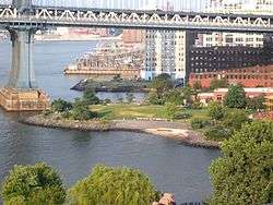

The Empire–Fulton Ferry section of the park is 4.5 acres (1.8 ha) of waterfront parkland that is directly adjacent to Main Street.[56] This part of the park was formerly a state park, but was incorporated into Brooklyn Bridge Park in 2010.[57] The part of the park offers a lawn with picnic tables and a boardwalk with views of the East River, Brooklyn Bridge, Manhattan Bridge and Lower Manhattan.
Tobacco Warehouse and Empire Stores

Two Civil-War era structures, the Tobacco Warehouse and Empire Stores, are also located on the site. The Tobacco Warehouse lacks a roof, and is used for outdoor concerts and similar events. Plans to renovate the aging Tobacco Warehouse to house St. Ann's Warehouse, a venue for theater and community use, are underway.[58]
In 2010, St. Ann's Warehouse was designated as the leasee for the Tobacco warehouse and launched a $27 million capital campaign to activate the space. In its current, roofless state, the Tobacco Warehouse assumes a trapezoidal footprint made up of a rectangle and adjacent triangle. Marvel Architects designed an 18,000-square-foot enclosed building with a performance space similar to St. Ann's previous warehouse theaters; a second, 1,000-square-foot multi-use community space for local artists, educational and community groups; artists' support spaces; offices, and a waterside lobby with archways and access points to the Park. Original brick walls will be preserved and visible throughout the foyers, theater, and Community Room. The 7,600-square-foot triangle space will be left open-air to be landscaped by Michael Van Valkenburgh Associates and open to the public during Park hours, serving as an entrance for the theater and Community Room from New Dock Street.[59]
In 2013, Brooklyn developer Midtown Equities was selected to redevelop the abandoned Empire Stores warehouses into a mix of commercial, retail and office space, designed by Studio V Architecture.[60][61] The adaptive reuse plan calls for commercial uses including restaurant, event, retail, and office space. It will also include a public passageway through the center of the building leading to a public courtyard and a public rooftop open space. Midtown Equities has discussed with the Brooklyn Historical Society to include 3,200 square feet of exhibition space to celebrate Brooklyn's industrial history.[59]
After reconstruction, the western part of the park opened in late summer 2011 with new park plantings, improved lighting, and the restored, 1922-era Jane's Carousel, purchased from Idora Park, Youngstown and housed in an all-weather acrylic and steel pavilion designed by French architect Jean Nouvel, which opened September 15, 2011.[62][63] The carousel and its pavilion are the gift of David and Jane Walentas to Brooklyn Bridge Park.[64] The carousel pavilion was designed by architect Jean Nouvel and commissioned by Walentas to allow the carousel to operate year-round. The carousel is maintained and operated by Friends of Jane's Carousel, a not-for-profit entity, guaranteeing the carousel's upkeep for up to thirty years.[64]
In October 2016, a large, 9-by-12-foot (2.7 by 3.7 m) sign with the word "DUMBO" on it was placed in the John Street area of the park. The sign, called the DUMBO Reflector, is created by neighborhood artist David Crumley. The interactive sign allows for people in the area to use hashtags to interact with the sign's displays.[65]
Ferry service
Brooklyn Bridge Park's Piers 1 and 6 are both expected to be served by the Citywide Ferry Service[66] starting in 2017.[67][68]
References
- 1 2 "Governor Paterson Announces Major Step for Brooklyn Bridge Park" (Press release). June 20, 2009. Retrieved March 9, 2012.
- ↑ "About Us: Overview". Brooklyn Bridge Park Corporation. Retrieved December 11, 2014.
- 1 2 3 "Brooklyn Bridge Park: Site History". Retrieved September 6, 2013.
- 1 2 3 4 5 6 7 8 Final Environmental Impact Statement (FEIS), Chapter 7. Historical Resources (PDF) (Report). December 12, 2005. Retrieved June 3, 2015.
- ↑ "Battle of Long Island, 26–29 August 1776". Retrieved September 6, 2013.
Military History Encyclopedia on the Web
- ↑ "Endangered Buildings Initiative". The New York Landmarks Conservancy. Retrieved March 21, 2012.
- ↑ "NYCDOT Bridges Information". New York City Department of Transportation. Retrieved March 1, 2012.
- ↑ "Rudy Bruner Award for Urban Excellence". Bruner Foundation. Retrieved September 6, 2013.
- 1 2 "Final Environmental Impact Statement (FEIS), Chapter 1. Project Description, Project Planning". December 12, 2005. Archived from the original on December 9, 2010. Retrieved September 6, 2013.
Empire State Development Corporation
- ↑ "About Us". Retrieved April 4, 2012.
- ↑ Waldman, Amy (January 25, 1998). "NEIGHBORHOOD REPORT: BROOKLYN WATERFRONT; One Park, Many Squabbles". The New York Times. Retrieved April 4, 2012.
- 1 2 "Brooklyn Bridge Park, The Park". Retrieved September 6, 2013.
- 1 2 3 Memorandum of Understanding, Brooklyn Bridge Park (PDF) (Report). May 2, 2005. Retrieved April 4, 2012.
- ↑ https://www.nycgovparks.org/parks/brooklyn-bridge-park/dailyplant/12665
- ↑ https://www.nycgovparks.org/parks/brooklyn-bridge-park/dailyplant/18193
- ↑ https://www.nycgovparks.org/parks/south-oxford-park/pressrelease/20975
- ↑ Modified General Project Plan (PDF) (Report). June 15, 2010. Retrieved April 4, 2012.
- ↑ Memorandum of Understanding (PDF) (Report). August 1, 2011. Retrieved April 4, 2012.
- ↑ "Brooklyn Bridge Park Construction Begins". The New York Sun. January 30, 2008. Retrieved July 16, 2010.
- 1 2 "Governor Paterson and Mayor Bloomberg Open First Section of Brooklyn Bridge Park" (Press release). New York State. March 22, 2010. Retrieved April 4, 2012.
- 1 2 "Mayor Bloomberg, Governor Patterson and Local Elected Officials Open Pier 6 at Brooklyn Bridge Park and Kick Off Governor's Island's 2010 Public Season" (Press release). New York City. June 5, 2010. Retrieved April 4, 2012.
- ↑ "Brooklyn Bridge Park, About Us". Brooklyn Bridge Park. Retrieved April 4, 2012.
- ↑ "Jane's Carousel Opens at Newly Refurbished Portion of Brooklyn Bridge Park". Brooklyn Bridge Park. September 15, 2011. Retrieved April 4, 2012.
- ↑ "Pier 1". Archived from the original on May 18, 2012. Retrieved September 6, 2013.
- ↑ "Mayor Bloomberg Announces Selection of Toll Brothers/Starwood Capital Group Joint Venture to Develop Hotel and Residential Complex at Pier 1 in Brooklyn Bridge Park" (Press release). June 19, 2012. Retrieved June 19, 2012.
- ↑ "Impressive Feat, HNTB's Pedestrian Bridge to Brooklyn Bridge Park". May 23, 2011. Retrieved May 31, 2012.
- ↑ "Squibb Park Bridge". Brooklyn Bridge Park. Retrieved December 11, 2014.
- ↑ "Fulton Ferry Landing". Archived from the original on May 17, 2012. Retrieved September 6, 2013.
- ↑ "Fulton Ferry Landing". http://www.brooklynbridgepark.org. Retrieved December 11, 2014. External link in
|publisher=(help) - ↑ Stephen Smith (28 January 2015). "Work Halted at Brooklyn Bridge Park's Pier 1 Over Height Questions". New York YIMBY. Retrieved 31 January 2015.
- ↑ Lisa W. Foderado (25 January 2015). "By Blocking View of the Brooklyn Bridge, a Building Incites a Battle". New York Times. Retrieved 31 January 2015.
- 1 2 "Pier 2". http://www.brooklynbridgepark.org. Retrieved December 11, 2014. External link in
|publisher=(help) - 1 2 "Pier 3: Greenway Terrace". http://www.brooklynbridgepark.org. Retrieved December 11, 2014. External link in
|publisher=(help) - ↑ "Park Design: Sound Attenuation". http://www.brooklynbridgepark.org. Retrieved December 11, 2014. External link in
|publisher=(help) - ↑ "Sustainability - Brooklyn Bridge Park". www.brooklynbridgepark.org. Retrieved 2016-10-20.
- ↑ "Dahn Vo: We the People". http://www.publicartfund.org. Retrieved December 11, 2014. External link in
|publisher=(help) - ↑ Colon, David. "Here's What Brooklyn Bridge Park Pier 3 Is Expected To Look Like". Gothamist. Retrieved 2016-10-20.
- ↑ "Brooklyn Bridge Park is one step closer to completion". am New York. Retrieved 2016-10-20.
- 1 2 "Pier 4: Beach". http://www.brooklynbridgepark.org. Retrieved December 11, 2014. External link in
|publisher=(help) - 1 2 "Fields and Picnic Area Open in Brooklyn Park". nytimes.com. Retrieved September 6, 2013.
- ↑ "Men's Soccer Team Has a New Home at Pier 5 Brooklyn Bridge Park". SFCathletics.com. Retrieved September 6, 2013.
- ↑ "In the Bag: Bagot's Two Goals Seals Home Opener For Terriers on Tuesday Night". SFCAthletics.com. Retrieved September 11, 2013.
- 1 2 "Pier 5". http://www.brooklynbridgepark.org. Retrieved December 11, 2014. External link in
|publisher=(help) - ↑ "Brooklyn Bridge Park Marina: Safe and Sustainable". http://www.bbpmarina.com. Retrieved December 11, 2014. External link in
|publisher=(help) - ↑ "Future Park: Pier 5 Marina". http://www.brooklynbridgepark.org. Retrieved December 11, 2014. External link in
|publisher=(help) - ↑ "Brooklyn Bridge Park Marina: About". http://www.bbpmarina.com. Retrieved December 11, 2014. External link in
|publisher=(help) - 1 2 "Pier 6". Archived from the original on May 18, 2012. Retrieved September 6, 2013.
- ↑ "Pier 6". http://www.brooklynbridgepark.org. Retrieved December 11, 2014. External link in
|publisher=(help) - ↑ "MAYOR BLOOMBERG, GOVERNOR PATERSON AND LOCAL ELECTED OFFICIALS OPEN PIER 6 AT BROOKLYN BRIDGE PARK AND KICK OFF GOVERNORS ISLAND'S 2010 PUBLIC SEASON" (Press release). June 5, 2010. Retrieved May 31, 2012.
- ↑ "Park Phasing". Archived from the original on August 19, 2013. Retrieved September 6, 2013.
- ↑ "Future Park: Pier 6 Landscape/Viewing Platform". http://www.brooklynbridgepark.org. Retrieved December 11, 2014. External link in
|publisher=(help) - ↑ Danger zone! Getting to the new Pier 6 is no joyride, by Gary Buiso, The Brooklyn Paper, 2010-06-25
- 1 2 "Brooklyn Bridge Park Corporation Assumes Management of Main Street Portion of Park" (Press release). December 2, 2010. Archived from the original on March 11, 2013. Retrieved September 6, 2013.
- ↑ "Main Street". Archived from the original on October 14, 2012. Retrieved September 6, 2013.
- ↑ "Future Park: Main Street". http://www.brooklynbridgepark.org. Retrieved December 11, 2014. External link in
|publisher=(help) - ↑ "Empire Fulton Ferry". Archived from the original on October 14, 2012. Retrieved September 6, 2013.
- ↑ Calder, Rich (December 17, 2009). "Brooklyn Bridge Park finally set to open". New York Post. Archived from the original on January 18, 2010. Retrieved October 24, 2013.
- ↑ "Agreement Reached with Local Community and Preservation Groups to Provide Expansion of Brooklyn Bridge Park" (Press release). May 21, 2012. Archived from the original on April 15, 2013. Retrieved September 6, 2013.
- 1 2 "Mayor Bloomberg Breaks Ground on New Home for St. Ann's Warehouse at BBP" (Press release). http://www.brooklynbridgepark.org. Retrieved December 11, 2014. External link in
|publisher=(help) - ↑ Dunlap, David (September 25, 2013). "Another Pass at Revitalizing Abandoned Warehouse Space on the Waterfront". nytimes.com. The New York Times. Retrieved December 5, 2013.
- ↑ Chaban, Matt (August 25, 2013). "Local Developer Chosen to Transform Brooklyn Bridge Area". New York Daily News.
- ↑ Official site Jane's Carousel
- ↑ "Jane's Carousel". Retrieved September 6, 2013.
- 1 2 "Jane's Carousel Opens at Newly Refurbished Portion of BBP". http://www.brooklynbridgepark.org. Retrieved December 11, 2014. External link in
|publisher=(help) - ↑ Warerkar, Tanay (2016-10-14). "Flashy, functional sign celebrating Dumbo arrives in Brooklyn Bridge Park". Curbed NY. Retrieved 2016-10-20.
- ↑ DNAinfoNewYork. "Proposed Routes for NYC's Expanded Ferry Service". Scribd. Retrieved September 22, 2016.
- ↑ "Citywide Ferry Service to Launch in June 2017, Official Says". DNAinfo New York. 2016-03-03. Retrieved 2016-09-22.
- ↑ "New York City's Ferry Service Set to Launch in 2017". NBC New York. Retrieved 9 May 2016.
External links
| Wikimedia Commons has media related to Brooklyn Bridge Park. |
- Official website
- Brooklyn Heights Association
- Brooklyn Bridge Park Flickr Photographs
- Brooklyn Bridge Park Video Sustainable Construction of Pier 1
- Brooklyn Bridge Park Video A Tour With Michael Van Valkenburgh
| |||||||||||||||||||||||||
| |||||||||||||||||||||||||
| |||||||||||||||||||||||||
| |||||||||||||||||||||||||