Manhattan Waterfront Greenway


The Manhattan Waterfront Greenway is a foreshoreway for walking or cycling, 32 miles (51 km) long, around the island of Manhattan. The largest portions are operated by the New York City Department of Parks. It is separated from motor traffic, and many sections also separate pedestrians from cyclists. There are three principal parts — the East, Harlem and Hudson River Greenways.
Components
Hudson River Greenway
The Hudson River Greenway is the longest greenway in Manhattan, running along the West Side, from Dyckman Street in the north to Battery Park in the south, mostly through Riverside Park and Hudson River Park. A gap in West Harlem was filled in early October 2008 with the opening of the Harlem Piers bike lane. A roughly 10-block detour in the west 80s, where a walkway had crumbled into the river in the late 20th century,[1] was eliminated on May 20, 2010, when the rebuilt section of greenway was opened.[2]
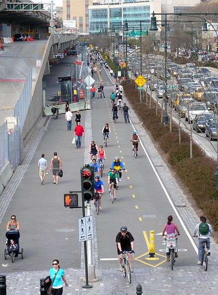
The Hudson River Greenway is the most heavily used bikeway in the United States.[3] The majority of it is close to Hudson River water level, except the portion north of George Washington Bridge where it climbs steeply, to approximately 160 feet (49 m) and includes Inspiration Point.
At the downtown end, renovation work on the South Ferry subway station resulted in a connection through Battery Park to the East River Greenway in 2013.
Travelers to Brooklyn use a bike lane in Warren Street and a one-way bike path (opened in September 2008) through the north end of City Hall Park to connect to the Brooklyn Bridge. Those arriving from Brooklyn use lanes in Park Row and Murray Street to reach the Greenway.
Mixed use paths continue a mile north from Dyckman Street into Inwood Hill Park alongside the western ball fields, at which point the path crosses the Amtrak rail tracks using a bridge with steps. This continues northeast into the park as part of the park trail system and connects north to bikeways in Spuyten Duyvil in the Bronx via the Henry Hudson Bridge, and east to the bike lane on 218th Street leading to the Broadway Bridge.
The Harbor Ring is an initiative to create a 50-mile bike route along the Lower Hudson River, Upper New York Bay, and Kill van Kull that would incorporate bike paths along the Greenway.[4][5][6]
The Hudson River Greenway is part of the East Coast Greenway, a 3,000 mile long trail system connecting Maine to Florida.
East River Greenway
This runs along the East Side, from Battery Park and past South Street Seaport to a dead end at 125th Street, East Harlem with a 1.3 miles (2.1 km) gap from 34th to 60th streets in Midtown where pedestrians use busy First and Second Avenues to get around United Nations Headquarters between the Upper East Side and Kips Bay portions of the Greenway. Cyclists going further north who do not wish to carry their bike up the long flight of stairs at 81st Street must skip the 60th Street access and continue in the on-street bike lanes another 1.1 miles (1.8 km) to 83rd Street.
Some places are narrow due to sinkholes being blocked off by protective fencing, and the Captain Patrick J. Brown Walk squeezes between the highway and the dock of Con Edison's East River Station, requiring slower speeds. Other parts are shared space with motor access to Waterside Plaza (at Stuyvesant Cove Park), or a filling station. Approximately a mile near the southwest end is in the shadow of the elevated FDR Drive. This part is to be improved by the East River Esplanade project.
In the summer of 2008 the East River Greenway, along with the Brooklyn Heights Promenade, provided viewing locations to see the New York City Waterfalls.
In October 2011, the city and state reached an agreement to use the western portion of Robert Moses Playground for an expansion of the United Nations campus. In exchange, the United Nations Development Corporation would pay $73 million to fund the development of the gap in the Greenway between 38th and 60th streets.[7]
Harlem River Greenway
Partially following the route of the old Harlem River Speedway, the Harlem River Greenway is the shortest portion of the Manhattan Waterfront Greenway and is completely uninterrupted, running north through lower Highbridge Park from 155th Street, at the north end of Central Harlem, to Dyckman Street in northern Manhattan, between the Harlem River and Harlem River Drive.[8] Users of the East River Greenway must use ordinary streets through East Harlem to reach this portion. A bike lane in Dyckman Street through Inwood connects to Inwood Hill Park and the Hudson River Greenway via a 2015 bike ramp at the western end of Dyckman St.[9][10]
U-shaped barrier
There are plans for a new storm barrier along the southern third of the greenway, between West 57th and East 42nd Streets.[11][12][13] The final proposal, which is geographically U-shaped, will include many features.[11] Under the elevated FDR Drive structure above South Street will be storm barriers hanging from the viaduct's ceiling, which will drop down in case of a storm.[11] A "Battery Berm" will be located at Battery Park, and a maritime museum will be opened on the site of a former Coast Guard building there.[11] The proposal, by Rebuild by Design, will also include components for storm barriers in Hunts Point, Bronx and on Staten Island.[13] The first component, a 2.19-mile-long (4 km) barrier on the Lower East Side between Montgomery and East 13th Streets called "The Bridging Berm", will cost $335 million.[14] In addition to storm protection, the berm—the first of three of the barrier's components—will also provide a pedestrian pathway and bikeway on top of berm, boating and fishing docks, a slope down to current sports fields, upgraded ADA-accessible ramps for bridges across the FDR Drive, and construction materials such as "slurry walls, concrete blocks, a compacted embankment, a clay cap, topsoil and salt-tolerant landscaping."[14] The total cost of the project is over $3.5 billion.[15]
See also
References
Notes
- ↑ "Mayor Bloomberg And Commissioner Benepe Break Ground On Riverwalk In Riverside Park" (Press release). New York City Department of Parks & Recreation. October 17, 2007. Retrieved February 26, 2010.
- ↑ First Look: Detour No More on the Hudson River Greenway, Streetsblog, May 20, 2010, retrieved May 23, 2010
- ↑ "Statement of Noah Budnick, Deputy Director for Advocacy, Transportation Alternatives to the New York City Hudson River Park Trust Public Meeting and Hearing on Pier 40 Redevelopment", Transportation Alternatives, May 3, 2007. Accessed September 25, 2007. "The Hudson River Greenway is the most heavily used bike path in the United States, it is a 24-hour, 365 day a year route."
- ↑ Cruz, Vera (February 24, 2013). "New York Harbor and New Jersey meet Bike and pedestrian route planned to encourage recreation and transportation". Hudson Reporter. Retrieved 2013-03-19.
- ↑ "The Harbor Ring". Transportation Alternatives. Retrieved 2013-03-19.
- ↑ Goodyear, Sarah (October 12, 2012). "Could You One Day Ride Your Bike All the Way Around New York Harbor?". Atlantic Cities. Retrieved 2013-03-19.
- ↑ Orden, Erica (October 6, 2011). "Greenway Plan Gets 'Missing Link'". The Wall Street Journal. Retrieved October 6, 2011.
- ↑ Hibridge Park"1 MB". 1 MB nycparks.gov
- ↑ "Cycling the Manhattan Waterfront Greenway". The New York Times. May 5, 2011.
- ↑ "Long-Awaited Ramp to Hudson River Greenway Opens on Dyckman Street". DNAinfo.com. September 17, 2015.
- 1 2 3 4 "Rebuild by Design – BIG U". Rebuildbydesign.org. Retrieved 2014-06-11.
- ↑ BIG Team Final Proposal pdf
- 1 2 Beck, Graham T. (2014-04-08). "New York Unveils Dramatic New Storm-Protection Proposals – Next City". Nextcity.org. Retrieved 2014-06-11.
- 1 2 Beck, Graham T. (2014-06-04). "New York's New $335 Million Storm-Surge Barrier Will Transform the Lower East Side – Next City". Nextcity.org. Retrieved 2014-06-11.
- ↑ Rogers, Josh (2011-05-11). "City floats new version of 'Seaport City,' but Lower Manhattan committee asks for storm help now". Downtown Express. Retrieved 2014-06-11.
External links
| Wikimedia Commons has media related to Manhattan Waterfront Greenway. |
East River Greenway:
Coordinates: 40°47′17″N 73°59′01″W / 40.788°N 73.9836°W
| |||||||||||||||||||||||||
| |||||||||||||||||||||||||
| |||||||||||||||||||||||||
| |||||||||||||||||||||||||