Brooklyn Heights Promenade


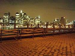
The Brooklyn Heights Promenade (also called the Esplanade[1]), a 1,826-foot (557 m)-long platform and pedestrian walkway cantilevered over Interstate 278 in Brooklyn Heights, Brooklyn, in New York City, United States. With views of Lower Manhattan's skyline and the New York Harbor, it came about as the unplanned byproduct of competing proposals for the highway’s route that were resolved in the midst of World War II. Actual construction came after the war. As a structure constructed over a roadway, the Promenade is owned by the NYCDOT and is not considered a park; however, NYC Parks maintains the entire Promenade.[2]
The Promenade runs between the Brooklyn Bridge and the ramp north of Atlantic Avenue. The walkway itself is curtailed at both ends. Due to the area's topography, the Promenade is four stories; from top to bottom, they are the walkway, eastbound I-278, westbound I-278, and service road.
Planning
The need for a highway to connect the boroughs of Brooklyn and Queens predated the war. In 1939, a topographical engineer with New York’s then new City Planning Department mapped a route for such a highway that hewed quite closely to the East River waterfront of the two boroughs.
Independently, the "master builder" Robert Moses subsequently envisioned a somewhat more inland route. A proposal by Moses in 1941 to run the Brooklyn–Queens Expressway through the neighborhood was successfully opposed.[2] This was in part due to the Brooklyn Eagle issue of September 19, 1942 having alarmed some residents of Brooklyn Heights with the front page headline "Plan for Express Highway Is Shocking". The Eagle reported that the route proposed by Moses would bisect the neighborhood, even requiring at least the partial demolition of a recently built marble courthouse. The news galvanized the leadership of the Brooklyn Heights Association, representing one of the city’s more affluent and politically connected communities. Two men in particular, Roy M.D. Richardson, the association’s president and a Wall Street corporate lawyer, and Ferdinand W. ("Fred") Nitardy, vice president for plant construction of Squibb Pharmaceuticals, which then had a major complex at the north end of Brooklyn Heights, lobbied hard for a route that would move the highway westward, to run along the water-fronting escarpment at the neighborhood’s edge. Meanwhile, engineers with Andrews & Clark, the firm commissioned to build the highway, similarly concluded that the route along the escarpment was best, since an inland route would entail excessive condemnation costs.
By March 10, 1943, the date of a hearing before the City Planning Commission, the outer, or Furman Street, route had been settled on. The proposal presented at the hearing was for two roadways of three lanes each in either direction to be built side-by-side on top of the Heights escarpment. A plea by Nitardy at the hearing for the highway to be built on two separate decks with a "cover" on which he could restore his rear garden was heard with seeming sympathy by Moses. Moses agreed to the idea of the cover, but then, a month after the hearing, Brooklyn Borough President John Cashmore, whose office was in charge of the project, informed Nitardy by letter that the adopted plan "would preclude the use by you of the deck" above the highway, which would instead become a public esplanade.[2] Moses betrayed no hint that a similar plan, with two highway decks covered, not by private gardens but by a public walkway, had already been drawn up at Andrews & Clark.
Warehouse demolition and opening
Demolition of the warehouses that lined the eastern, or inland, side of Furman Street began in the fall of 1946, and construction of a triple cantilever section followed for the next few years. The southern half of the Promenade was opened to the public on October 7, 1950,[3] and the northern half on December 7, 1951 (the tenth anniversary of the World War II attack in Pearl Harbor, Hawaii). The highway itself was not ready for traffic until 1954.
Apprehensions by many Brooklyn Heights residents that the Promenade as a public attraction would bring noisy disruptions and crime to the area were soon dissipated as it became a popular destination for residents and tourists alike. However, with the Promenade’s success, various claims were made for who originated the idea. A proposal by the landowner and early developer Hezekiah Pierrepont in about 1827 for a promenade along the bluff of the Heights figures nowhere in the correspondence over the proposed highway. Other claims for and by Heights residents and others also lack documentation. One member of the Andrews & Clark team, the engineer S. Starr Walbridge, in 1982 claimed unequivocally that he had conceived both the cantilevering and the Promenade. However, the project’s chief engineer, Ernest J. Clark, disputed his claim, contending that the design was a team effort and had "evolved" through considering various means of supporting the highway and testing their stresses and appearance. The firm’s artist Julian Michele, the man who did the renderings of the designs and whom Walbridge cited for corroboration, declined comment. Another engineer, Phillips H. Lovering, who was credited with mathematically working out the precise shapes of the cantilevers, agreed with Clark’s view.

In 1953 a new concern arose when it was learned that the Port Authority of New York and New Jersey, which owned the warehouses still lining the west – or harborside – of Furman Street, wished to reserve the right to replace them with structures up to 70 feet in height, or 20 feet higher than the level of the Promenade. The prospective loss of views from the still-new Promenade caused an outpouring of protest unprecedented for that time, and a rare "town hall" meeting was held at Brooklyn's Borough Hall on May 7, 1953. Among officials on the dais were Cashmore, Moses, and Austin Tobin, executive director of the Port Authority. They met the audience’s questions and demands with evasiveness. Moses afterward responded to a letter questioning his position by writing, "The city cannot do a piece of spot zoning simply protecting this particular view." Nevertheless, the city on June 25 did just that, limiting structures across from the Promenade to a height of 50 feet. It went further in 1974 by enacting a "Special Scenic District" that imagined a "view plane" extending from the edge of the Promenade to a line roughly midway in the East River that no new structure could pierce. This remains in effect.
The remaining warehouses were demolished in the late 1950s, opening up what still had been partly obstructed views.
Early 21st century
With the construction of Brooklyn Bridge Park, the foreground view from the Promenade, which until the early 1980s had been of pre-container-era freighters docking at the piers below, and men unloading and loading them, takes on a different and more landscape-like look. Hopes for a major reconstruction of the well-worn triple cantilever section were disappointed in 2011 by the decision of NYSDOT that there was insufficient funding for more than spot repairs. Gentrification continues along the Promenade's route.[4]
In popular culture
It has appeared in the movies Annie Hall and Moonstruck, among others.[5]
References
Notes
- ↑ http://forgotten-ny.com/2013/09/middagh-street-brooklyn-heights/
- 1 2 3 "Brooklyn Heights Promenade, Text of Parks Dept Sign". Retrieved 11 May 2014.
- ↑ "Brooklyn Heights Promenade - Great Public Spaces | Project for Public Spaces". PPS. Retrieved 2014-08-22.
- ↑ Brooklyn Heights (2001-09-12). "Brooklyn Heights | South Brooklyn Network". Southbrooklyn.com. Retrieved 2014-08-22.
- ↑ "Brooklyn Heights Promenade". Nyharborparks.org. Retrieved 2014-08-22.
Further reading
- Reports from the Brooklyn Eagle, New York Times, and New York Herald Tribune, 1942-1950.
- Minutes of meetings of the Brooklyn Heights Association’s governors, 194l-1945.
- Interviews and correspondence with officials, senior residents of Brooklyn Heights, and members of the Andrews & Clark and Clarke+Rapuano engineering firms, with reports on these published in Brooklyn Heights Press articles 1976-1982.
- Letters from Robert Moses in 1953 and 1979.
- Minutes of the City Planning Commission hearing of March 10, 1943.
- The Power Broker: Robert Moses and the Fall of New York by Robert A. Caro (Knopf, 1974) for a background on Moses and the development politics of the time, although Caro has nothing to say about the Promenade or the triple cantilever.
- Public Works: A Dangerous Trade by Robert Moses (McGraw-Hill, 1970) for insight about a certain animus Moses felt toward Brooklyn Heights.
- A History of the City of Brooklyn by Henry R. Stiles (Brooklyn, 1867–1870), for the early promenade proposal by Hezekiah Pierrepont.
- The Brooklyn Heights Promenade by Henrik Krogius (The History Press, Charleston, SC, 2011).
External links
| Wikimedia Commons has media related to Brooklyn Heights Promenade. |
- Official website
- Film about Brooklyn Heights Promenade by Karl Junkersfeld and Martin Schneider on Vimeo
Coordinates: 40°41′51″N 73°59′50″W / 40.6975°N 73.9973°W