Robert Moses Playground

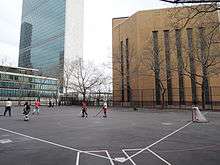
Robert Moses Playground is a 1.3-acre (0.53 ha) playground and park in the New York City borough of Manhattan. It is located in the Murray Hill neighborhood on First Avenue between 41st and 42nd streets, immediately south of the United Nations Headquarters. The park is named for New York's "master builder" Robert Moses.
The land for the park was obtained in 1937 as part of the Queens-Midtown Tunnel construction in exchange for the taking of a portion of St. Gabriel's Park (now named St. Vartan Park) for an approach roadway. The Park itself was completed in 1941 and shares the block with the large ventilation building for the tunnel. It was named for Moses in 1982.[1][2]
The playground is often used for roller hockey, and the East End Hockey Association has been organizing games at the site since 1972.[3]
Land reclamation
Since 1982, there have been at least three attempts to take the park's land for building projects.[4]
The most recent proposal was raised by the United Nations in June 2010. Under this deal, the city would then expand the nearby East River Greenway to compensate for the loss of this park.[5] On December 8, 2010, Manhattan Community Board 6 gave their support to this plan, providing that the esplanade was expanded.[6] In March 2011, the city gave approval to move ahead with a feasibility study for this project as part of Mayor Bloomberg's Vision 2020: New York City Comprehensive Waterfront Plan.[7][8]
If agreed by the city and the heads of both houses of the New York State Legislature, the United Nations Development Corporation could begin preliminary planning for a new office tower, which could be no taller than the 505-foot (154 m) tall Secretariat Building. The UN would pay the city at least $65 million for the park. The plan is opposed by some residents of Tudor City, which is across the street from the park.[9]
On October 5, 2011, the city and state reached an agreement to use the western portion of Robert Moses Playground for an expansion of the United Nations campus. In exchange, the United Nations Development Corporation would pay $73 million to fund the development of the East River esplanade between 38th and 60th streets.[10] To make up for the loss of parkland, the City will convert Asser Levy Place into parkland.[11]
References
- ↑ "Robert Moses Playground Highlights". New York City Department of Parks & Recreation. Retrieved March 5, 2011.
- ↑ "St. Vartan Park Highlights". New York City Department of Parks & Recreation. Retrieved August 20, 2011.
- ↑ Greenberg, Jonathan (November 1, 1993). "Smooth Skating". New York. Retrieved August 21, 2011.
- ↑ Mindlin, Alex (April 1, 2007). "At a Longstanding Playground, Yet Another Plan to End the Games". The New York Times. Retrieved March 7, 2011.
- ↑ Agovino, Theresa (June 13, 2010). "City plots huge land deal with U.N.". Crain's New York Business. Retrieved March 7, 2011.
- ↑ Zimmer, Amy (December 10, 2010). "East Side Park May Get Razed to Build New United Nations Tower". Digital Network Associates. Retrieved March 11, 2011.
CB6 passed a resolution on Wednesday supporting the UN takeover of Robert Moses Park as long as they get what they want in return. They know getting a replacement park won’t be easy, and they don’t want small pocket parks.
- ↑ "Vision 2020: New York City Comprehensive Waterfront Plan" (PDF). New York City Department of City Planning. March 2011. p. 118. Retrieved October 6, 2011.
- ↑ Zimmer, Amy (April 14, 2011). "City Could Open Swath of East River Waterfront to the Public". Digital Network Associates. Retrieved May 11, 2011.
Rep. Carolyn Maloney secured $475,000 in federal funding from the Surface Transportation Program and state funding from the Department of Environmental Conservation for a feasibility study of the engineering, design, landscaping and other planning related to the new esplanade for her East Side district.
- ↑ Foderaro, Lisa W. (September 30, 2011). "Land Deal With U.N. Would Fill a Big Gap in the Waterfront Greenway". The New York Times. Retrieved September 30, 2011.
- ↑ Orden, Erica (October 6, 2011). "Greenway Plan Gets 'Missing Link'". The Wall Street Journal. Retrieved October 6, 2011.
- ↑ Holland, Heather (October 23, 2013). "Asser Levy Place to Close Permanently to Make Way for Park". DNAinfo New York. Retrieved 5 May 2015.
Coordinates: 40°44′54″N 73°58′11″W / 40.748232°N 73.96966°W
| |||||||||||||||||||||||||
| |||||||||||||||||||||||||
| |||||||||||||||||||||||||
| |||||||||||||||||||||||||