Creta, Oklahoma
| Creta, Oklahoma | |
|---|---|
| Unincorporated community | |
 Creta, Oklahoma | |
| Coordinates: 34°31′00″N 99°32′59″W / 34.51667°N 99.54972°W | |
| Country | United States |
| State | Oklahoma |
| County | Jackson |
| Elevation | 1,352 ft (412 m) |
| Time zone | Central (CST) (UTC-6) |
| • Summer (DST) | CDT (UTC-5) |
| Area code(s) | 580 |
| GNIS feature ID | 1101955[1] |
Creta (also Creta Station and Eldorado) is an unincorporated community along Oklahoma State Highway 6 in Jackson County, Oklahoma.[1] It is at latitude 34.517 and longitude -99.55. The elevation is 1,352 feet. It is 6.5 miles west of Olustee, Oklahoma and 10 miles south-southeast of Duke, Oklahoma. It is on the south bank of Gypsum Creek.[2]
References
- 1 2 "Creta, Oklahoma". Geographic Names Information System. United States Geological Survey.
- ↑ DeLorme (2003). Oklahoma Atlas & Gazetteer. Yarmouth, Maine: DeLorme. ISBN 0-89933-283-8
Municipalities and communities of Jackson County, Oklahoma, United States | ||
|---|---|---|
| City | 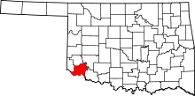 | |
| Towns | ||
| Unincorporated communities | ||
| Ghost towns | ||
Coordinates: 34°09′25″N 99°33′00″W / 34.157°N 99.55°W
This article is issued from Wikipedia - version of the 7/24/2015. The text is available under the Creative Commons Attribution/Share Alike but additional terms may apply for the media files.