Osage County, Oklahoma
| Osage County, Oklahoma | |
|---|---|
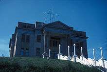 Osage County Courthouse | |
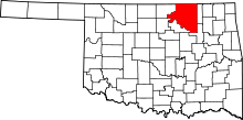 Location in the U.S. state of Oklahoma | |
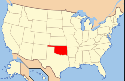 Oklahoma's location in the U.S. | |
| Founded | 1907 |
| Seat | Pawhuska |
| Largest city | Pawhuska |
| Area | |
| • Total | 2,304 sq mi (5,967 km2) |
| • Land | 2,246 sq mi (5,817 km2) |
| • Water | 58 sq mi (150 km2), 2.5% |
| Population (est.) | |
| • (2013) | 47,987 |
| • Density | 21/sq mi (8/km²) |
| Congressional district | 3rd |
Osage County is the largest County in the state of Oklahoma by area. Created at 1907 with Oklahoma's statehood the county was named for and is home to the Osage tribe and is contiguous with the Osage Nation Reservation.
History
By the 19th century, the Osage and other Siouan tribes had been forced to move west from the Ohio Valley across the Mississippi River. The Osage became established as a powerful nation in the areas of present-day Missouri and Arkansas between the Missouri and Red rivers, as well as extending to the west. By 1760, they had increased their range to include the present Osage County. Historically one of the most powerful Great Plains tribes, their numbers were reduced by infectious disease and warfare after encounter with Europeans.
In 1825, they ceded their claim to the land in present-day Oklahoma to the United States government, which included it in a "perpetual outlet to the west given to the Cherokee Nation by the Treaty of New Echota" in 1835. This treaty was to accomplish Cherokee removal to the Indian Territory. During the American Civil War, on December 26, 1861, a band of pro-Union Creek and Seminole fought with a Confederate Army unit at the Battle of Chustenahlah[1] on Bird Creek, near the present town of Skiatook.[2] Generally the Five Civilized Tribes were allied with the Confederacy.
In 1870, the Osage finally prepared for removal from Kansas, after having negotiated payment for their land. They purchased 1.57 million acres (6,400 km2) of their former territory in present-day Oklahoma from the Cherokee. By owning it, they had a stronger position in relation to the US government than did other tribes.[3] The Osage Agency was established in 1872 at Deep Ford, later renamed as Pawhuska. It was designated as the county seat when Oklahoma was admitted as a state. The other chief settlements in the 1870s were Hominy and Fairfax; each of the three was settled by a major Osage band.[3]
In 1875 the US designated their land as the Osage Reservation. Because the tribe owned the land directly, they retained more control over their affairs than did tribes who only had rights to land held "in trust" by the United States government.[3] This reservation became part of the Oklahoma Territory under the Oklahoma Organic Act of 1890. It became a semi-autonomous district by the Oklahoma Enabling Act of 1906, and Osage County at the time of Oklahoma Statehood in 1907.[2] At that time, there were 2,229 registered Osage members.[3]
As owners, the Osage retained the communal mineral rights to their reservation lands. In October 1897, the Phoenix Oil Company drilled the first successful oil well on the Osage reservation and Oklahoma Territory. It was located along Butler Creek. In 1901, Phoenix Oil and Osage Oil companies combined their assets to form the Indian Territory Illuminating Oil Company (ITIO). It arranged with the Bureau of Indian Affairs to sub-lease the eastern part of the Osage reservation until 1916. When ITIO's lease expired, the United States government supervised the public auctioning of leases for 160-acre (65 ha) tracts.[2]
All subsurface minerals, including oil, are owned by the Osage Nation and held in trust for them by the Federal Government. Each mineral lease was negotiated by the Osage National Council and approved by the U. S. Secretary of the Interior.[2] While the government forced allotment of lands and distribution of 160-acre (65 ha) plots to tribal members for farming in the early 20th century, the tribe continued to hold their "surplus" land after the distribution.[3] Other tribes were forced to give up such "surplus" and allow for sales to non-Indians. The Osage distributed their surplus communal land to tribal members, so that in 1906 each Osage was given a total of 657 acres (266 ha), nearly four times the amount that other Indian households received in the allotment process. Later the enrolled Osage and their descendants received oil and other mineral royalties as payments based on these "headrights".[3]
By 1920, the Osage were receiving lucrative revenues from royalties and were counted as the richest people in the country. During the 1920s, Osage County was the site of the infamous Osage Indian murders. Because of the great wealth being generated by oil, an estimated 60 tribal members were killed as whites tried to gain their headrights, royalties or land. The FBI believed that several white husbands of Osage women had committed or ordered their murders.[3] Other Osage were tricked out of their legal rights by unscrupulous white opportunists, in some cases attorneys or businessmen appointed by local courts as "guardians" to the Osage, under the requirements of a 1921 law Congress intended to be for their protection, but which put them more at risk.
The Osage called in the FBI to help solve several murders in the Kyle family, and three men were convicted and sentenced. But, many murders were never solved. To try to protect the Osage, Congress passed a law in 1925 prohibiting the inheritance of headrights by persons who were not at least half Osage in ancestry.[3]
Geography
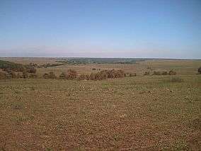
According to the U.S. Census Bureau, the county has a total area of 2,304 square miles (5,970 km2), of which 2,246 square miles (5,820 km2) is land and 58 square miles (150 km2) (2.5%) is water.[4] It is the largest county in Oklahoma by area. Most of the county is in the Osage Plains, and consists of open prairie. The eastern part of the county contains the Osage Hills, an extension of the Flint Hills in Kansas.[2] Tallgrass Prairie Preserve is north of Pawhuska.
Holmes Peak is a mountain northwest of Tulsa in Osage County. It was named by the United States Board on Geographic Names on October 5, 1983 for the fictional detective, Sherlock Holmes. The name was proposed by Richard S. Warner.[5] Holmes Peak is the highest point in the Tulsa Metropolitan area, with an elevation of 1,030 feet (310 m), though it ranks only as the 379th highest point in the state.[6]
Gray Horse Creek, Drum Creek and Salt Creek all drain the southwestern part of the county and flow into the Arkansas River, which is part of the county's southern and western boundaries. Eastern Osage County drains into Caney River, Bird Creek, Hominy Creek, and Delaware Creek. All of these streams flow into the Verdigris River.[2]
Lakes and reservoirs in the county include:[2]
In 2012, the Osage Nation took over management of Wah-Sha-She State Park, which includes Hulah Lake, after state budget cuts would have closed it. Hunting is allowed there. The land is owned by the US Army Corps of Engineers, which developed the lake.[7] The tribe's agreement with the COE runs through 2016, before which it will assess the operation.[8]
It is the most populous and the second-largest county geographically (after Corson County, South Dakota) of the six U.S. counties that lie entirely within an Indian reservation. (The six counties in descending order of area are Corson; Osage; Oglala Lakota and Todd in South Dakota; Sioux in North Dakota; and Mahnomen in Minnesota.) Three other counties, Thurston in Nebraska; and Dewey and Ziebach in South Dakota, lie entirely in parts of two separate Indian reservations. A total of nine US counties lie entirely within reservation territory. Dewey County is slightly larger in area than Osage.
Adjacent counties
- Cowley County, Kansas (northwest)
- Chautauqua County, Kansas (north)
- Washington County (east)
- Tulsa County (southeast)
- Pawnee County (southwest)
- Kay County (west)
- Noble County (west)
Demographics
| Historical population | |||
|---|---|---|---|
| Census | Pop. | %± | |
| 1910 | 20,101 | — | |
| 1920 | 36,536 | 81.8% | |
| 1930 | 47,334 | 29.6% | |
| 1940 | 41,502 | −12.3% | |
| 1950 | 33,071 | −20.3% | |
| 1960 | 32,441 | −1.9% | |
| 1970 | 29,750 | −8.3% | |
| 1980 | 39,327 | 32.2% | |
| 1990 | 41,645 | 5.9% | |
| 2000 | 44,437 | 6.7% | |
| 2010 | 47,472 | 6.8% | |
| Est. 2015 | 47,887 | [9] | 0.9% |
| U.S. Decennial Census[10] 1790-1960[11] 1900-1990[12] 1990-2000[13] 2010-2013[14] | |||
As of the 2010 United States Census,[15] there were 47,472 people, 18,205 households, and 12,972 families residing in the county. The population density was 20.6 people per square mile (8/km²). There were 21,143 housing units at an average density of 9.2 per square mile (3.5/km²). The racial makeup of the county was 66% White, 11.4% Black or African American, 14.4% Native American, 0.3% Asian, less than 0.1% Pacific Islander, 0.8% from other races, and 7.1% from two or more races. Almost 3% of the population were Hispanic or Latino of any race.
There were 18,205 households, out of which 32.6% included children under the age of 18, 54.2% were married couples living together, 12% had a female householder with no husband present, 5.1% had a male householder with no wife present,and 28.7% were non-families. Individuals living alone accounted for 24.8% of households and 10.8% had someone living alone who was 65 years of age or older. The average household size was 2.53 and the average family size was 2.99.
In the county, the population was spread out with 24.3% under the age of 18, 7.4% from 18 to 24, 23.1% from 25 to 44, 29.9% from 45 to 64, and 15.3% who were 65 years of age or older. The median age was 41.4 years. For every 100 females there were 101.39 males. For every 100 females age 18 and over, there were more than 100 males.
The median income for a household in the county was $42,847, and the median income for a family was $53,815. Males had a median income of $42,658 versus $32,352 for females. The per capita income for the county was $21,797. About 11% of families and 13% of the population were below the poverty line, including 18% of those under age 18 and 11% of those age 65 or over.
Politics
| Voter Registration and Party Enrollment as of January 15, 2016[16] | |||||
|---|---|---|---|---|---|
| Party | Number of Voters | Percentage | |||
| Democratic | 12,179 | 48.50% | |||
| Republican | 10,111 | 40.27% | |||
| Unaffiliated | 2,810 | 11.19% | |||
| Total | 25,110 | 100% | |||
| Year | Republican | Democrat |
|---|---|---|
| 2012 | 62.64% 11,242 | 37.36% 6,704 |
| 2008 | 61.86% 12,160 | 38.14% 7,498 |
| 2004 | 58.70% 11,467 | 41.30% 8,068 |
| 2000 | 51.15% 8,138 | 47.39% 7,540 |
Communities
Cities
- Barnsdall
- Bartlesville (part)
- Hominy
- Pawhuska
- Ponca City (part)
- Sand Springs (part)
- Shidler
- Tulsa (part)
Towns
Census-designated place
Unincorporated communities
NRHP sites
The following sites in Osage County are listed on the National Register of Historic Places:
- Bank of Bigheart, Barnsdall
- Bank of Burbank, Burbank
- Bank of Hominy, Hominy
- Barnsdall Main Street Well Site, Barnsdall
- Blacksmith's House, Pawhuska
- Chapman-Barnard Ranch Headquarters, Pawhuska
- Chief Ne-Kah-Wah-She-Tun-Kah Grave and Statue, Fairfax
- Pawhuska City Hall, Pawhuska
- Fred Drummond House, Hominy
- First National Bank and Masonic Lodge, Fairfax
- Hominy Armory, Hominy
- Hominy Osage Round House, Hominy
- Hominy School, Hominy
- Immaculate Conception Church, Pawhuska
- Lincoln Colored School, Fairfax
- Marland Filling Station, Hominy
- Osage Agency, Pawhuska
- Osage Bank of Fairfax, Fairfax
- Osage County Courthouse, Pawhuska
- Pawhuska Armory, Pawhuska
- Pawhuska Downtown Historic District, Pawhuska
- Wolverine Oil Company Drayage Barn, Avant
- Osage Nation Museum, Pawhuska
In popular culture
It is the setting of Oklahoma native Tracy Letts' play August: Osage County (2007), which won the Pulitzer Prize for Drama and a Tony Award in 2008, and the 2013 movie adaptation of the same name which stars Meryl Streep. Filming took place in rural Osage County, including Pawhuska, Barnsdall and Bartlesville.[18]
See also
References
- ↑ "On this date in Civil War history: December 26, 1861 - Battle of Chustenahlah (150th Anniversary)".
- 1 2 3 4 5 6 7 May, Jon D. Osage County, Encyclopedia of Oklahoma History and Culture. Retrieved September 25, 2011.
- 1 2 3 4 5 6 7 8 McAuliffe, Dennis (1994). Bloodland: A Family Story of Oil, Greed and Murder on the Osage Reservation. Council Oak Books. p. 43. ISBN 978-1-57178-083-6.
- ↑ "2010 Census Gazetteer Files". United States Census Bureau. August 22, 2012. Retrieved February 21, 2015.
- ↑ Tulsa City-County Library.How did Holmes Peak get its name? Accessed July 26, 2015.
- ↑ "Holmes Peak." peakery.com. Accessed July 26, 2015
- ↑ "Why It's Hard to Privatize and Move State Parks". NPR. Retrieved January 6, 2013.
- ↑ Polacca, Benny. "Osage Nation takes over Wah-Sha-She State Park", Osage News, 6 June 2012, Retrieved May 26, 2013
- ↑ "County Totals Dataset: Population, Population Change and Estimated Components of Population Change: April 1, 2010 to July 1, 2015". Retrieved July 2, 2016.
- ↑ "U.S. Decennial Census". United States Census Bureau. Retrieved February 21, 2015.
- ↑ "Historical Census Browser". University of Virginia Library. Retrieved February 21, 2015.
- ↑ Forstall, Richard L., ed. (March 27, 1995). "Population of Counties by Decennial Census: 1900 to 1990". United States Census Bureau. Retrieved February 21, 2015.
- ↑ "Census 2000 PHC-T-4. Ranking Tables for Counties: 1990 and 2000" (PDF). United States Census Bureau. April 2, 2001. Retrieved February 21, 2015.
- ↑ "State & County QuickFacts". United States Census Bureau. Retrieved November 12, 2013.
- ↑ "American FactFinder". United States Census Bureau. Retrieved 2008-01-31.
- ↑ https://www.ok.gov/elections/documents/20160115%20-%20Registration%20By%20County%20%28vr2420%29.pdf
- ↑ "Dave Leip's Atlas of U.S. Presidential Elections". Retrieved 2016-03-19.
- ↑ http://www.tulsaworld.com/scene/movienews/august-osage-county-director-talks-about-making-filming-in-oklahoma/article_8e9dde51-211d-573d-938b-4c6b7bdb6731.html
External links
- 2030 Osage County Comprehensive Plan Retrieved July 25, 2014.
- Osage County Sheriff's Office
 |
Cowley County, Kansas | Chautauqua County, Kansas | | |
| Kay County Noble County |
|
Washington County | ||
| ||||
| | ||||
| Pawnee County | Tulsa County |
Municipalities and communities of Osage County, Oklahoma, United States | ||
|---|---|---|
| Cities | | |
| Towns | ||
| CDP | ||
| Unincorporated communities |
| |
| Footnotes | ‡This populated place also has portions in an adjacent county or counties | |
| Counties |  | |
|---|---|---|
| Principal city | ||
| Cities over 20k | ||
| Cities 10k-20k | ||
| Cities 5k-10k | ||
| Cities and towns 1k-5k | ||
Coordinates: 36°38′N 96°24′W / 36.63°N 96.40°W