Woods County, Oklahoma
| Woods County, Oklahoma | |
|---|---|
 Location in the U.S. state of Oklahoma | |
 Oklahoma's location in the U.S. | |
| Founded | 1893 |
| Named for | Samuel Wood |
| Seat | Alva |
| Largest city | Alva |
| Area | |
| • Total | 1,290 sq mi (3,341 km2) |
| • Land | 1,286 sq mi (3,331 km2) |
| • Water | 3.5 sq mi (9 km2), 0.3% |
| Population (est.) | |
| • (2013) | 9,041 |
| • Density | 6.9/sq mi (3/km²) |
| Congressional district | 3rd |
| Time zone | Central: UTC-6/-5 |
Woods County is a county located in the northwestern part of the U.S. state of Oklahoma. As of the 2010 census, the population was 8,878.[1] Its county seat is Alva.[2] The county is named after Samuel Newitt Wood, a renowned Kansas populist.[3]
History
The known explorer of the area now contained within Woods County was George C. Sibley, who traveled through in 1811. He visited a salt formation near the present town of Freedom, Oklahoma, then followed the Mountain Fork of the Arkansas River southeastward to the Great Salt Plains. In 1843, Nathan Boone traveled along the Cimarron River.[3]
The area was part of the so-called Cherokee Outlet, acquired by the Cherokee Nation under the Treaty of New Echota. It later became important for cattle ranching. The Dodge City and Red Fork Trail, a branch of the Chisholm Trail followed the north bank of the Cimarron River en route to Kansas. The U. S. Government acquired the Cherokee Outlet under Congressional Acts in 1889, 1891 and 1893, and divided the area into counties. One of these was designated M County, prior to opening the area for settlement. The Secretary of the Interior designated Alva as the county seat. M County was renamed Woods County by an election on November 6, 1894.[3] Woods County became part of Oklahoma Territory.
The Constitutional Convention of 1906 created Major County and Alfalfa County from southern and eastern parts of Woods County and added a part of Woodward County to Woods County.[3]
Geography
According to the U.S. Census Bureau, the county has a total area of 1,290 square miles (3,300 km2), of which 1,286 square miles (3,330 km2) is land and 3.5 square miles (9.1 km2) (0.3%) is water.[4] It is located along the Kansas border.
Major Highways
 U.S. Highway 64
 U.S. Highway 281
 State Highway 11
 State Highway 14
 State Highway 34
 State Highway 45
Adjacent counties
- Comanche County, Kansas (north)
- Barber County, Kansas (northeast)
- Alfalfa County (east)
- Major County (south)
- Woodward County (southwest)
- Harper County (west)
Demographics
| Historical population | |||
|---|---|---|---|
| Census | Pop. | %± | |
| 1910 | 17,567 | — | |
| 1920 | 15,939 | −9.3% | |
| 1930 | 17,005 | 6.7% | |
| 1940 | 14,915 | −12.3% | |
| 1950 | 14,526 | −2.6% | |
| 1960 | 11,932 | −17.9% | |
| 1970 | 11,920 | −0.1% | |
| 1980 | 10,923 | −8.4% | |
| 1990 | 9,103 | −16.7% | |
| 2000 | 9,089 | −0.2% | |
| 2010 | 8,878 | −2.3% | |
| Est. 2015 | 9,304 | [5] | 4.8% |
| U.S. Decennial Census[6] 1790-1960[7] 1900-1990[8] 1990-2000[9] 2010-2013[1] | |||
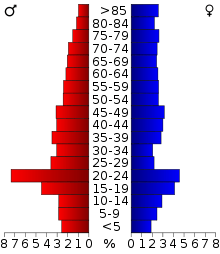
As of the 2010 United States Census, there were 8,878 people, 3,533 households, and 2,133 families residing in the county. The population density was 7 people per square mile (3/km²). There were 4,478 housing units at an average density of 3.5 per square mile (1.3/km²).[10] The racial makeup of the county was 88.4% white, 3.3% black or African American, 2.4% Native American, 0.9% Asian, less than 0.1% Pacific Islander, 2.3% from other races, and 2.7% from two or more races. 4.8% of the population were Hispanic or Latino of any race.
There were 3,533 households, out of which 23.2% had children under the age of 18 living with them, 47.9% were married couples living together, 7.6% had a female householder with no husband present, and 40.2% were non-families. 32.3% of households were made up of individuals and 8.8% had someone living alone who was 65 years of age or older. 8.2% of the population was institutionalized The average household size was 2.23 and the average family size was 2.82.
In the county, the population was spread out with 18.8% under the age of 18, 18.6% from 18 to 24, 22.3% from 25 to 44, 23.1% from 45 to 64, and 17.2% who were 65 years of age or older. The median age was 34.7 years. For every 100 females there were 114.8 males. For every 100 females age 18 and over, there were 109.9 males.
The median income for a household in the county was $47,255, and the median income for a family was $60,500. Males had a median income of $39,754 versus $23,897 for females. The per capita income for the county was $22,935. About 8% of families and 16% of the population were below the poverty line, including 10% of those age 65 or over.
Politics
| Voter Registration and Party Enrollment as of January 15, 2016[11] | |||||
|---|---|---|---|---|---|
| Party | Number of Voters | Percentage | |||
| Democratic | 1,386 | 29.25% | |||
| Republican | 2,901 | 61.23% | |||
| Unaffiliated | 451 | 9.52% | |||
| Total | 4,738 | 100% | |||
| Year | Republican | Democrat |
|---|---|---|
| 2016 | 80.34% 2,947 | 14.23% 522 |
| 2012 | 80.25% 2,727 | 19.75% 671 |
| 2008 | 77.71% 3,043 | 22.29% 873 |
| 2004 | 75.89% 3,166 | 22.74% 932 |
| 2000 | 68.56% 2,774 | 30.52% 1,235 |
Communities
See also
References
- 1 2 "State & County QuickFacts". United States Census Bureau. Retrieved November 13, 2013.
- ↑ "Find a County". National Association of Counties. Retrieved 2011-06-07.
- 1 2 3 4 Reichenberger, Donovan. "Woods County," Encyclopedia of Oklahoma History and Culture, Oklahoma Historical Society, 2009. Accessed April 5, 2015.
- ↑ "2010 Census Gazetteer Files". United States Census Bureau. August 22, 2012. Retrieved February 22, 2015.
- ↑ "County Totals Dataset: Population, Population Change and Estimated Components of Population Change: April 1, 2010 to July 1, 2015". Retrieved July 2, 2016.
- ↑ "U.S. Decennial Census". United States Census Bureau. Retrieved February 22, 2015.
- ↑ "Historical Census Browser". University of Virginia Library. Retrieved February 22, 2015.
- ↑ Forstall, Richard L., ed. (March 27, 1995). "Population of Counties by Decennial Census: 1900 to 1990". United States Census Bureau. Retrieved February 22, 2015.
- ↑ "Census 2000 PHC-T-4. Ranking Tables for Counties: 1990 and 2000" (PDF). United States Census Bureau. April 2, 2001. Retrieved February 22, 2015.
- ↑ "General Housing Characteristics: 2010 - United States -- County by State; and for Puerto Rico". U.S. Census Bureau. Retrieved October 18, 2013.
- ↑ https://www.ok.gov/elections/documents/20160115%20-%20Registration%20By%20County%20%28vr2420%29.pdf
- ↑ "Dave Leip's Atlas of U.S. Presidential Elections". Retrieved 2016-11-19.
 |
Comanche County, Kansas | Barber County, Kansas | | |
| Harper County | |
Alfalfa County | ||
| ||||
| | ||||
| Woodward County | Major County |
Municipalities and communities of Woods County, Oklahoma, United States | ||
|---|---|---|
| Cities | | |
| Towns | ||
| Unincorporated communities | ||
Coordinates: 36°46′N 98°52′W / 36.77°N 98.86°W