Cleveland County, Oklahoma
| Cleveland County, Oklahoma | |
|---|---|
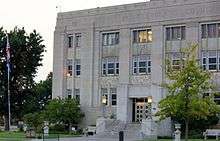 Cleveland County Courthouse | |
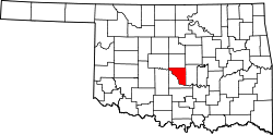 Location in the U.S. state of Oklahoma | |
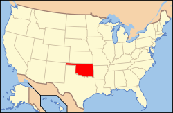 Oklahoma's location in the U.S. | |
| Founded | 1890 |
| Named for | Grover Cleveland |
| Seat | Norman |
| Largest city | Norman |
| Area | |
| • Total | 558 sq mi (1,445 km2) |
| • Land | 539 sq mi (1,396 km2) |
| • Water | 19 sq mi (49 km2), 3.5% |
| Population (est.) | |
| • (2014) | 269,908 |
| • Density | 500/sq mi (193/km²) |
| Congressional district | 4th |
| Time zone | Central: UTC-6/-5 |
| Website |
www |
Cleveland County is a county in the central part of the U.S. state of Oklahoma. The population was 255,755 at the 2010 census,[1] making it the third-most populous county in Oklahoma. Its county seat is Norman.[2] The county was named after U.S. President Grover Cleveland.[3]
Cleveland County is part of the Oklahoma City, OK Metropolitan Statistical Area.
History
Originally occupied by the Quapaw tribe, the Quapaw ceded the area to the U.S. Government soon after the Louisiana Purchase in 1818. During the late 1820s and 1830s, the area was given to the Creek and Seminole tribes after their forced removal from the southeastern United States. An agreement between the two tribes resulted in this area being part of the Seminole Nation, located west of the Creek Nation.
In 1866, these tribes were forced to cede the area to the Federal Government for siding with the Confederacy during the American Civil War. The area became part of the Unassigned Lands and was opened for white settlement on April 22, 1889.
After the passage of the Organic Act in 1890, Cleveland County was organized as County 3 and Norman became the county seat. For a short time, Cleveland County was known as Little River County, until an election in 1890. The voters selected the name Cleveland in honor of President Grover Cleveland over the name Lincoln.[3]
Geography
According to the U.S. Census Bureau, the county has a total area of 558 square miles (1,450 km2), of which 539 square miles (1,400 km2) is land and 19 square miles (49 km2) (3.5%) is water.[4] It is the seventh smallest county in the state.
Cleveland County contains the reservoir Lake Thunderbird 5,349 acres (21.65 km2), constructed between 1962 and 1965.
Cleveland County is the origin of the Little River, a tributary of the Canadian River, 90 miles (140 km) long. The Canadian River defines the southern border of Cleveland County.
Adjacent counties
- Oklahoma County (north)
- Pottawatomie County (east)
- McClain County (southwest)
- Canadian County (northwest)
Demographics
| Historical population | |||
|---|---|---|---|
| Census | Pop. | %± | |
| 1890 | 6,605 | — | |
| 1900 | 16,388 | 148.1% | |
| 1910 | 18,843 | 15.0% | |
| 1920 | 19,389 | 2.9% | |
| 1930 | 24,948 | 28.7% | |
| 1940 | 27,728 | 11.1% | |
| 1950 | 41,443 | 49.5% | |
| 1960 | 47,600 | 14.9% | |
| 1970 | 81,839 | 71.9% | |
| 1980 | 133,173 | 62.7% | |
| 1990 | 174,253 | 30.8% | |
| 2000 | 208,016 | 19.4% | |
| 2010 | 255,755 | 22.9% | |
| Est. 2015 | 274,458 | [5] | 7.3% |
| U.S. Decennial Census[6] 1790-1960[7] 1900-1990[8] 1990-2000[9] 2010-2013[1] | |||
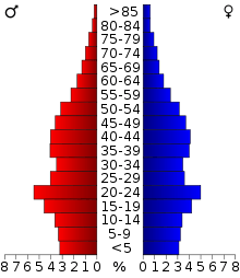
As of the census of 2010,[10] there were 255,755 people, 98,306 households, and 64,182 families residing in the county. The population density was 458 people per square mile (177/km²). There were 104,821 housing units at an average density of 188 per square mile (72.5/km²). The racial makeup of the county was 79.3% white, 4.2% black or African American, 4.7% Native American, 3.8% Asian, 0.1% Pacific Islander, 2.3% from other races, and 5.6% from two or more races. 7.0% of the population were Hispanic or Latino of any race.
There were 98,306 households, of which almost half (49.9%) included married couples living together and more than a third (34.7%) were non-families. Almost a third (32.9%) included children under the age of 18, 10.7% had a female householder with no husband present, and 4.7% had a male householder with no wife present. More than a fourth (25.9%) of households consisted of a sole individual and 6.9% were individuals 65 years of age or older living alone. The average household size was 2.49 and the average family size was 3.02.
In the county, the population was spread out with 23.1% under the age of 18, 14.2% from 18 to 24, 28.1% from 25 to 44, 24.4% from 45 to 64, and 10.2% who were 65 years of age or older. The median age was 32.7 years. For every 100 females there were 99.9 males. For every 100 females age 18 and over, there were 98.1 males.
The median income for a household in the county was $53,759, and the median income for a family was $67,412. Males had a median income of $45,580 versus $34,801 for females. The per capita income for the county was $26,640. About 7.2% of families and 12.1% of the population were below the poverty line, including 12.7% of those under age 18 and 5.8% of those age 65 or over.
Politics
| Voter registration and party enrollment as of January 15, 2016[11] | |||||
|---|---|---|---|---|---|
| Party | Number of voters | Percentage | |||
| Democratic | 51,934 | 36.18% | |||
| Republican | 69,480 | 48.40% | |||
| Unaffiliated | 22,141 | 15.42% | |||
| Total | 143,555 | 100% | |||
| Year | Republican | Democratic |
|---|---|---|
| 2016 | 57.14% 62,538 | 35.48% 38,829 |
| 2012 | 62.97% 59,116 | 37.03% 34,771 |
| 2008 | 62.00% 64,749 | 38.00% 39,681 |
| 2004 | 65.90% 65,720 | 34.10% 34,007 |
| 2000 | 62.22% 47,393 | 36.49% 27,792 |
Education
The University of Oklahoma is located in Norman. It is the largest university in Oklahoma with approximately 30,000 students.
Libraries
Pioneer Library System operates branch libraries in ten cities in Cleveland, McClain and Pottawatomie counties.[13]
Transportation
Airports
The University of Oklahoma Westheimer Airport is owned by the University of Oklahoma and located 3 nautical miles (5.6 km) northwest of Norman.
Major highways
Communities
- Etowah
- Hall Park
- Lexington
- Moore
- Noble
- Norman (county seat)
- Oklahoma City (mostly in Oklahoma County)
- Purcell (mostly in McClain County)
- Slaughterville
NRHP sites
The following sites in Cleveland County are listed on the National Register of Historic Places:
- Bavinger House, Norman
- Beta Theta Pi Fraternity House, Norman
- Bizzell Library, Norman
- Casa Blanca, Norman
- Cleveland County Courthouse, Norman
- DeBarr Historic District, Norman
- Patricio Gimeno House, Norman
- Oscar B. Jacobson House, Norman
- Ledbetter House, Norman
- Mardock Mission, Stella
- Moore Public School Building, Moore
- Moore-Lindsay House, Norman
- Norman City Park New Deal Resources, Norman
- Norman Historic District, Norman
- Norman Public Library, Norman
- Boyd House (University of Oklahoma), Norman
- Santa Fe Depot, Norman
- Sooner Theater Building,
- United States Post Office--Norman, Norman
- James C. Nance Bridge, Lexington/Purcell
References
- 1 2 "State & County QuickFacts". United States Census Bureau. Retrieved November 8, 2013.
- ↑ "Find a County". National Association of Counties. Archived from the original on 2011-05-31. Retrieved 2011-06-07.
- 1 2 Wilson, Linda D. "Cleveland County," Encyclopedia of Oklahoma History and Culture, 2009. Accessed March 28, 2015.
- ↑ "2010 Census Gazetteer Files". United States Census Bureau. August 22, 2012. Retrieved February 18, 2015.
- ↑ "County Totals Dataset: Population, Population Change and Estimated Components of Population Change: April 1, 2010 to July 1, 2015". Retrieved July 2, 2016.
- ↑ "U.S. Decennial Census". United States Census Bureau. Archived from the original on May 11, 2015. Retrieved February 18, 2016.
- ↑ "Historical Census Browser". University of Virginia Library. Retrieved February 18, 2015.
- ↑ Forstall, Richard L., ed. (March 27, 1995). "Population of Counties by Decennial Census: 1900 to 1990". United States Census Bureau. Retrieved February 18, 2015.
- ↑ "Census 2000 PHC-T-4. Ranking Tables for Counties: 1990 and 2000" (PDF). United States Census Bureau. April 2, 2001. Retrieved February 18, 2015.
- ↑ "American FactFinder". United States Census Bureau. Archived from the original on 2013-09-11. Retrieved 2008-01-31.
- ↑ "Archived copy" (PDF). Archived from the original (PDF) on 2016-03-29. Retrieved 2016-02-19.
- ↑ "Dave Leip's Atlas of U.S. Presidential Elections". Retrieved 2016-11-19.
- ↑ "Pioneer Library System to buy Borders bookstore building in Norman". NewsOK. The Oklahoman. September 27, 2011. Retrieved 2011-10-25.
External links
- Encyclopedia of Oklahoma History and Culture - Cleveland County
- Oklahoma Digital Maps: Digital Collections of Oklahoma and Indian Territory
 |
Canadian County | Oklahoma County | | |
| |
Pottawatomie County | |||
| ||||
| | ||||
| McClain County |
Municipalities and communities of Cleveland County, Oklahoma, United States | ||
|---|---|---|
| Cities | | |
| Towns | ||
| Neighborhood | ||
| Footnotes | ‡This populated place also has portions in an adjacent county or counties | |
Coordinates: 35°12′N 97°20′W / 35.20°N 97.33°W