Corwin, Tippecanoe County, Indiana
| Corwin | |
|---|---|
| Ghost town | |
|
The grain elevators at Corwin | |
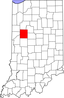 Tippecanoe County's location in Indiana | |
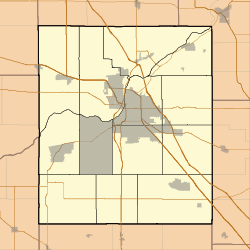 Corwin Location in Tippecanoe County | |
| Coordinates: 40°15′5″N 86°54′52″W / 40.25139°N 86.91444°WCoordinates: 40°15′5″N 86°54′52″W / 40.25139°N 86.91444°W | |
| Country | United States |
| State | Indiana |
| County | Tippecanoe |
| Township | Randolph |
| Elevation[1] | 735 ft (224 m) |
| Time zone | Eastern (EST) (UTC-5) |
| • Summer (DST) | EDT (UTC-4) |
| ZIP code | 47981 |
| Area code(s) | 765 |
| GNIS feature ID | 446668 |

Corwin was a small town, now extinct, in Randolph Township, Tippecanoe County, in the U.S. state of Indiana.
History
Corwin was laid out by Cyrus Foltz in 1856 and consisted of seven lots near the rail line which ran south out of Lafayette. The town never flourished, though, and was eclipsed by nearby Romney.[2] Later maps sometimes cite the town as Corwin Station.[3]
A post office was established at Corwin in 1854, but was discontinued in that same year.[4]
As of 9/19/2016 - The old grain silo has been removed. It appears on the Bing![5] map which is of an unknown date, however the Google[6] map shows it has been demolished.
Geography

Corwin is located at 40°15'5" North, 86°54'52" West (40.251426, -86.914397) at an elevation of approximately 740 feet. It sits in Randolph Township half a mile west of the town of Romney and is on a north/south CSX rail line.
Even though the community is now extinct, it is still cited by the USGS.[7]
References
- ↑ "US Board on Geographic Names". United States Geological Survey. October 25, 2007. Retrieved 2016-07-25.
- ↑ "Ghost Towns of Tippecanoe County". Retrieved 2008-11-15.
- ↑ Indiana Historical Society. Maps of Indiana Counties in 1876. 1968. (Reprinted from Illustrated Historical Atlas of the State of Indiana. Chicago: Baskin, Forster & Company, 1876.)
- ↑ "Tippecanoe County". Jim Forte Postal History. Archived from the original on September 9, 2005. Retrieved July 25, 2016.
- ↑ "Bing Maps - Driving Directions, Traffic and Road Conditions". binged.it. Retrieved 2016-09-19.
- ↑ "Google Maps". Google Maps. Retrieved 2016-09-19.
- ↑ "Corwin, Tippecanoe County, Indiana". Geographic Names Information System. United States Geological Survey. Retrieved 2016-07-25.
Municipalities and communities of Tippecanoe County, Indiana, United States | ||
|---|---|---|
| Cities | ||
| Towns | ||
| Townships | ||
| CDPs | ||
| Other unincorporated communities |
| |
| Ghost towns | ||
| Footnotes | ‡This populated place also has portions in an adjacent county or counties | |