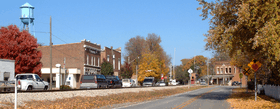
Battle Ground, Indiana
| Battle Ground | |
|---|---|
| Town | |
 | |
| Motto: "Historic Site Of The Battle Of Tippecanoe" | |
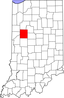 Tippecanoe County's location in Indiana | |
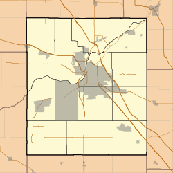 Battle Ground Location in Tippecanoe County | |
| Coordinates: 40°30′36″N 86°50′18″W / 40.51000°N 86.83833°WCoordinates: 40°30′36″N 86°50′18″W / 40.51000°N 86.83833°W | |
| Country | United States |
| State | Indiana |
| County | Tippecanoe |
| Township | Tippecanoe |
| Founded | 1867 |
| Government | |
| • Council President | Steve Egly |
| Area[1] | |
| • Town | 0.87 sq mi (2.25 km2) |
| • Land | 0.87 sq mi (2.25 km2) |
| • Water | 0 sq mi (0 km2) |
| Elevation[2] | 587 ft (179 m) |
| Population (2010)[3] | |
| • Town | 1,334 |
| • Estimate (2012[4]) | 1,399 |
| • Density | 1,533.3/sq mi (592.0/km2) |
| • Metro | 190,386 |
| Time zone | EST (UTC-5) |
| • Summer (DST) | EDT (UTC-4) |
| ZIP code | 47920 |
| Area code(s) | 765 |
| FIPS code | 18-03718[5] |
| GNIS feature ID | 430580 |
| Website |
www |
Battle Ground is a town in Tippecanoe Township, Tippecanoe County in the U.S. state of Indiana.[6] The population was 1,334 at the 2010 census. It is near the site of the Battle of Tippecanoe.
Battle Ground is part of the Lafayette, Indiana, Metropolitan Statistical Area.
History
In the late summer and fall of 1811, William Henry Harrison, then Governor of the Indiana Territory, organized a military expedition against the increasing resistance of the federation of Indian tribes being formed by the Shawnee brothers and chiefs, Tecumseh and Tenskwatawa, also known as the Prophet. With their community of Prophetstown as his objective, General Harrison marched from Vincennes, Indiana, at the head of a small army of about one thousand men.

General Harrison met with representatives of the Prophet on November 6, 1811, when he arrived at Prophetstown. He presented demands in the name of his government. General Harrison was to meet with the Prophet and his council the next day about the demands of the government. General Harrison set up his encampment on a ridge about a mile northwest of Prophet’s Town. Fearing[7] a surprise attack by the Prophet's forces, General Harrison placed his troops in battle formation, instructed his men to sleep fully clothed, and assigned a large detail of men for sentinel duty. On the morning of November 7, 1811, after 4 o’clock AM, the camp was attacked by the Prophet. After a fierce battle, General Harrison and his army defeated the Prophet’s Indian confederation at the Battle of Tippecanoe. This defeat all but ended the Indian wars in the Midwest, especially as Tecumseh was killed in a battle in Canada in 1813.
Battle Ground was consolidated in 1867 with the Town of Harrisonville. The governments of both towns decided to name the consolidation Battle Ground. The Town of Battle Ground was named for the Battle of Tippecanoe and the Town of Harrisonville was named after William Henry Harrison, commander of the American forces of the Battle of Tippecanoe.
The Tippecanoe battlefield monument was erected in 1908 and dedicated to the men who served and were killed in the Battle of Tippecanoe. The Tippecanoe Battlefield has been designated a National Historic Landmark. It includes a museum and recreation area. The Battle of Tippecanoe Outdoor Drama premiered at a nearby amphitheater in Battle Ground in 1989 and played for two summers.
The Battle Ground post office has been in operation since 1835.[8]
Battle Ground Historic District was listed on the National Register of Historic Places in 1985.[9]
Geography
Battle Ground is located at 40°30′36″N 86°50′18″W / 40.51000°N 86.83833°W (40.510110, -86.838220) in Tippecanoe Township, one and a quarter miles northwest of the Wabash River. Its elevation is approximately 585 feet. The small Harrison Creek begins near Battle Ground and flows east, while Burnett Creek skirts the town's western edge and flows southwest.
According to the 2010 census, Battle Ground has a total area of 0.86 square miles (2.23 km2), all land.[1]
Demographics
| Historical population | |||
|---|---|---|---|
| Census | Pop. | %± | |
| 1890 | 456 | — | |
| 1900 | 150 | −67.1% | |
| 1910 | 443 | 195.3% | |
| 1920 | 444 | 0.2% | |
| 1930 | 448 | 0.9% | |
| 1940 | 506 | 12.9% | |
| 1950 | 634 | 25.3% | |
| 1960 | 804 | 26.8% | |
| 1970 | 818 | 1.7% | |
| 1980 | 812 | −0.7% | |
| 1990 | 806 | −0.7% | |
| 2000 | 1,323 | 64.1% | |
| 2010 | 1,334 | 0.8% | |
| Est. 2015 | 1,474 | [10] | 10.5% |

2010 census
As of the census[3] of 2010, there were 1,334 people, 500 households, and 378 families residing in the town. The population density was 1,533.3 inhabitants per square mile (592.0/km2). There were 530 housing units at an average density of 609.2 per square mile (235.2/km2). The racial makeup of the town was 98.2% White, 0.2% African American, 0.1% Native American, 0.2% Asian, 0.7% from other races, and 0.4% from two or more races. Hispanic or Latino of any race were 2.1% of the population.
There were 500 households of which 37.4% had children under the age of 18 living with them, 60.6% were married couples living together, 11.4% had a female householder with no husband present, 3.6% had a male householder with no wife present, and 24.4% were non-families. 22.2% of all households were made up of individuals and 5.6% had someone living alone who was 65 years of age or older. The average household size was 2.67 and the average family size was 3.09.
The median age in the town was 38.1 years. 27.3% of residents were under the age of 18; 7.8% were between the ages of 18 and 24; 23.8% were from 25 to 44; 31.6% were from 45 to 64; and 9.3% were 65 years of age or older. The gender makeup of the town was 48.4% male and 51.6% female.
2000 census
As of the census[5] of 2000, there were 1,323 people, 470 households, and 375 families residing in the town. The population density was 1,152.5 people per square mile (444.2/km²). There were 486 housing units at an average density of 423.4 per square mile (163.2/km²). The racial makeup of the town was 98.79% White, 0.15% African American, 0.08% Native American, 0.15% Asian, 0.30% from other races, and 0.53% from two or more races. Hispanic or Latino of any race were 1.51% of the population.
There were 470 households out of which 46.8% had children under the age of 18 living with them, 68.1% were married couples living together, 9.1% had a female householder with no husband present, and 20.2% were non-families. 17.4% of all households were made up of individuals and 5.7% had someone living alone who was 65 years of age or older. The average household size was 2.81 and the average family size was 3.18.
In the town the population was spread out with 31.6% under the age of 18, 5.8% from 18 to 24, 35.3% from 25 to 44, 21.7% from 45 to 64, and 5.6% who were 65 years of age or older. The median age was 34 years. For every 100 females there were 93.7 males. For every 100 females age 18 and over, there were 91.3 males.
The median income for a household in the town was $52,857, and the median income for a family was $60,125. Males had a median income of $39,167 versus $26,667 for females. The per capita income for the town was $18,012. About 5.2% of families and 5.0% of the population were below the poverty line, including 6.2% of those under age 18 and 8.8% of those age 65 or over.
Schools
Battle Ground Elementary School and Battle Ground Middle School both lie inside of the town. Students from these schools continue on to Harrison High School for 9th-12th grade.
References
- 1 2 "G001 - Geographic Identifiers - 2010 Census Summary File 1". United States Census Bureau. Retrieved 2015-07-13.
- ↑ "US Board on Geographic Names". United States Geological Survey. 2007-10-25. Retrieved 2008-01-31.
- 1 2 "American FactFinder". United States Census Bureau. Retrieved 2012-12-11.
- ↑ "Population Estimates". United States Census Bureau. Archived from the original on 2013-06-17. Retrieved 2013-06-25.
- 1 2 "American FactFinder". United States Census Bureau. Archived from the original on 2013-09-11. Retrieved 2008-01-31.
- ↑ "Battle Ground, Indiana". Geographic Names Information System. United States Geological Survey. Retrieved 2016-07-25.
- ↑ Welcome Page, Battle of Tippecanoe Outdoor Drama 1990 Souvenir Program, Summer 1990.
- ↑ "Tippecanoe County". Jim Forte Postal History. Archived from the original on September 9, 2005. Retrieved July 25, 2016.
- ↑ National Park Service (2010-07-09). "National Register Information System". National Register of Historic Places. National Park Service.
- ↑ "Annual Estimates of the Resident Population for Incorporated Places: April 1, 2010 to July 1, 2015". Retrieved July 2, 2016.
- ↑ "Census of Population and Housing". Census.gov. Archived from the original on May 11, 2015. Retrieved June 4, 2015.
External links
Municipalities and communities of Tippecanoe County, Indiana, United States | ||
|---|---|---|
| Cities | ||
| Towns | ||
| Townships | ||
| CDPs | ||
| Other unincorporated communities |
| |
| Ghost towns | ||
| Footnotes | ‡This populated place also has portions in an adjacent county or counties | |