Heath, Indiana
| Heath | |
|---|---|
| Ghost town | |
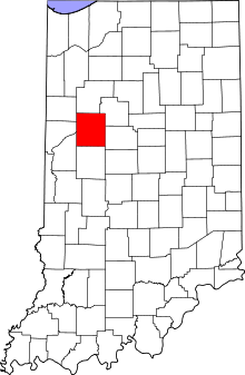 Tippecanoe County's location in Indiana | |
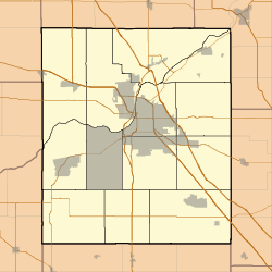 Heath Location in Tippecanoe County | |
| Coordinates: 40°27′41″N 86°44′00″W / 40.46139°N 86.73333°WCoordinates: 40°27′41″N 86°44′00″W / 40.46139°N 86.73333°W | |
| Country | United States |
| State | Indiana |
| County | Tippecanoe |
| Township | Perry |
| Elevation[1] | 669 ft (204 m) |
| Time zone | Eastern (EST) (UTC-5) |
| • Summer (DST) | EDT (UTC-4) |
| ZIP code | 47905 |
| Area code(s) | 765 |
| GNIS feature ID | 435952 |
Heath was a small town, now extinct, in Perry Township, Tippecanoe County, in the U.S. state of Indiana.
Geography
Heath is located at 40°27'41" North, 86°44'00" West (40.461389, -86.733333), on a bluff overlooking Wildcat Creek to the southeast. It is in Perry Township and has an elevation of approximately 669 feet. The post office at Heath was established in 1888 and discontinued in 1902.[2]
A few buildings in the community still exist, and it is still cited by the USGS.[3]
References
- ↑ "US Board on Geographic Names". United States Geological Survey. October 25, 2007. Retrieved 2016-07-25.
- ↑ Helbock, Richard W. United States Post Offices, Volume V - The Ohio Valley (2002) Scappoose, Oregon: La Posta Publications, p. 90
- ↑ "Heath, Indiana". Geographic Names Information System. United States Geological Survey. Retrieved 2016-07-25.
Municipalities and communities of Tippecanoe County, Indiana, United States | ||
|---|---|---|
| Cities | ||
| Towns | ||
| Townships | ||
| CDPs | ||
| Other unincorporated communities |
| |
| Ghost towns | ||
| Footnotes | ‡This populated place also has portions in an adjacent county or counties | |
This article is issued from Wikipedia - version of the 7/26/2016. The text is available under the Creative Commons Attribution/Share Alike but additional terms may apply for the media files.