CityPlace, Toronto
| CityPlace | |
|---|---|
| Neighbourhood | |
|
SkyBridge connecting CityPlace's Parade and Parade2. | |
 Vicinity | |
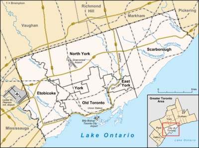 Location within Toronto | |
| Coordinates: 43°38′24″N 79°23′43″W / 43.640044°N 79.395179°WCoordinates: 43°38′24″N 79°23′43″W / 43.640044°N 79.395179°W | |
| Country | Canada |
| Province | Ontario |
| City | Toronto |
| Government | |
| • MP | Adam Vaughan (Spadina—Fort York) |
| • MPP | Han Dong (Trinity—Spadina) |
| • Councillor | Joe Cressy (Ward 20 Trinity—Spadina) |

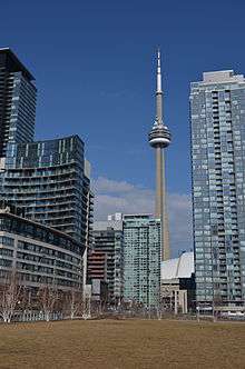
CityPlace is a neighbourhood in Downtown Toronto, Canada, within the former Railway Lands. When completed, this area will be the largest residential development ever created in Toronto. The area is bordered by Bathurst Street to the west, Lake Shore Boulevard to the south, and Front Street to the north and Blue Jays Way and the Rogers Centre to the east. Cityplace is also a 5- to 10-minute walk from King Street West and Liberty Village and a 10- to 20-minute walk from Toronto's financial district. The neighbourhood is also home to the Canoe Landing Park designed by famed Canadian writer and artist Douglas Coupland.
History
Railway Lands
What is now CityPlace was originally conceived as a way to revitalize what was Canadian National's former Spadina Street Yard Facility, which was part of the extensive Railway Lands in the waterfront area. Going as far back as 1965, when CN began to shift the functions of many of its yards in the Greater Toronto Area to a centralized facility in the northern suburb of Vaughan, there had been plans to revitalize this part of downtown. One of them called for the construction of a large television/telecommunications tower as a showcase of Canadian industry, which was realized in the 1970s with the CN Tower in addition to the massive Metro Centre which was later cancelled. Further development took place in the 1980s, with the 1984 completion of the Metro Toronto Convention Centre drawing new attention to the area.

With the arrival of new visitors and development of new commercial draws, a fresh master plan was drawn up by the City of Toronto for revitalization of this area. At the same time Via Rail, the sole remaining occupant of the Spadina Street Yards, relocated their local operations to the newly built Toronto Maintenance Centre in New Toronto, freeing up the lands necessary for the planned revitalization. Work commenced after the demolition of the last railway buildings with the construction of SkyDome, which was completed in 1989. At the same time, a new network of roads, parks and infrastructure began to take shape. The project proceeded smoothly until an economic downturn caused many of the development plans to be shelved, and much land stood abandoned until 1997 when construction of the Air Canada Centre arena commenced.
CityPlace
This began the third and final phase of redevelopment called CityPlace which called for a multipupose development of commercial, residential, and retail along the western section of the Railway Lands.
Block 31 development
The final portion of CityPlace to be developed is Block 31. Initially, the proposal for Block 31 included a 42-storey mixed-use tower (alongside schools and community centre). It was criticized for the shadows it would cast over nearby amenity spaces and the site's adjoining Canoe Landing Park, as well as the views it would partially obstruct.[1]
Following a round of public consultations in early 2015, the new schematic design for Block 31 was revealed. It will include two schools and a new community centre. Toronto District School Board (TDSB) and the Toronto Catholic District School Board (TCDSB) have both been designated to use the new space. The shared school building will seek to maximize spatial efficiency, with a common gym and theatre complex for both schools. Block 31's design attempts to maximize available green space. With an articulated green roof spanning the complex's footprint.[2] The 150,000 square foot complex is expected to cost $55 million to construct, and is set to be completed by 2019.[3]
The current CityPlace development
The current CityPlace development was conceived by Concord Adex Developments, the same company that helped revitalize a large section of former Expo 86 lands in Vancouver.
Project scope
- Project size: 18 hectares (44 acres) including an 8-hectare (20-acre)[4] community park. 7500 residential units upon completion.
- Residential development is divided into 10 street blocks, numbered from 1 to 10. Each street block contains a number of residential towers with its own sets of common facilities.
- Block 1 was developed first with 4 towers, namely Matrix A/B (Completed 2002) and Apex C/D (Completed 2003), all with Front Street West addresses. The street block features buildings directly facing the entertainment district and the closest walk to the Financial District.
- Block 2 features 1 building (Optima) only, directly behind the Rogers Centre, fronting on Navy Wharf Court. It features a heightened privacy comparing to the other interconnected towers. Completed 2003.
- Block 3 is the largest street block in the entire CityPlace complex, with 4 towers and a mid-rise building, as well as townhouses to decrease the tension of high density development. The project was named Harbour View Estates and was completed in 2006.
- Block 4 features 2 towers and a mid-rise, mirroring the Harbour View Estates both in location and in design. The buildings are named as WestOne, N1/N2 and The Gallery, was completed by October 2007.
- Block 5 contains one tower (Montage), completed in early 2009, and a mid-rise building (Neo), completed in late 2008.
- Block 6 has further progressed in design as trend evolves, with 2 towers and 1 mid-rise, Luna and Luna Vista. Completed April 2010
- Block 7-8 (Parade) Two towers with a 2 story bridge at floors 28 and 29, 2 podium buildings and 2 mid-rise buildings. Completed 2013.
- Block 9 contains the 8 acres (3.2 ha) Canoe Landing Park[5]
- Block 10 will contain the Panorama building with a 7 story podium/mid-rise and a luxury high rise. The high-rise will feature a number of 1500+sqft units with private elevators. Completed April 2010.
- Number of Units: over 5,000 residential units to date.
CityPlace buildings

| Rank | Name | Height ft |
Floors | Started | Completed | Address | Notes | Image |
|---|---|---|---|---|---|---|---|---|
| Apex[A] | 273 ft (83.2 m) | 28 | 2001 | 2003 | 381 Front Street West |  | ||
| Apex 2[A] | 371* | 36 | 2001 | 2003 | 397 Front Street West | |||
| The Gallery[A] | 108.3 ft (33.0 m) | 8 | 2005 September | 2007 July | 15 Brunel Court | |||
| Harbourview Estates [A] | 402 ft (122.5 m) | 40 | 2003 January | 2005 | 10 Navy Wharf Court |  | ||
| Harbourview Estates 2[A] | 503 ft (153.3 m) | 49 | 2003 January | 2005 | 35 Mariner Terrace | |||
| Harbourview Estates 3 North[A] | 278 ft (84.7 m)* | 26 | 2004 | 2005 | 3 Navy Wharf Court | |||
| Harbourview Estates 3 South[A] | 378 ft (115.2 m)* | 36 | 2004 | 2005 | 5 Mariner Terrace | |||
| Harbourview Estates [A] | 85.3 ft (26.0 m)* | 8 | 2004 | 2005 | 9 Spadina Avenue | |||
| Luna[A] | 229.7 ft (70.0 m) | 22 | 2007 January | 2010 April | 8 Telegram Mews | |||
| Luna Vista[A] | 413 ft (125.9 m) | 38 | 2007 January | 2010 April | 25 Capreol Court |  | ||
| Matrix 1[A] | 320 ft (97.5 m) | 32 | 2000 | 2002 | 361 Front Street West |  | ||
| Matrix 2[A] | 274 ft (83.5 m) | 28 | 2000 | 2002 | 373 Front Street West | |||
| Montage[A] | 476 ft (145.1 m) | 47 | 2006 November | 2009 February | 25 Telegram Mews |  | ||
| N1[A] | 425 ft (129.5 m)* | 41 | 2005 June | 2007 August | 15 Fort York Boulevard | 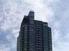 | ||
| N2[A] | 27 | 2009 | ||||||
| Neo[A] | 210 ft (64.0 m) | 16 | 2006 June | 2008 October | 4K Spadina Avenue | |||
| Optima[A] | 357.6 ft (109.0 m) | 34 | 2001 | 2003 | 81 Navy Wharf Court | |||
| Panorama[A] | 315 ft (96.0 m)* | 28 | 2008 January | 2010 April |  | |||
| Parade East[A] | 366 ft (111.6 m) | 39 | 2008 January | 2013 | 15 Iceboat Terrace / 10 Caperol Court |  | ||
| Parade West[A] | 418 ft (127.4 m) | 44 | 2008 January | 2012 November | 21 Iceboat Terrace / 151 Dan Leckie Way | |||
| West One[A] | 486 ft (148.1 m) | 49 | 2005 | 2007 October | 11 Brunel Court |  | ||
| Block 31 (separate developer, but within the community) | 3 | Pre-Construction |
(*) – denotes estimate
See Concord Pacific Masterplan in External Links
Transportation

With its location nestled between the Gardiner Expressway and Union Station, CityPlace is a very accessible area. The development is also serviced by the Toronto Transit Commission's 509 Harbourfront, 510 Spadina, and 511 Bathurst streetcar lines.
In addition, a median is being set aside along Bremner Boulevard, the main thoroughfare through Cityplace, so that it can be used for a streetcar route by the TTC in the future.
A footbridge (Puente de Luz or Bridge of Light) is a pedestrian and cycling crossing from CityPlace to Front Street across the railway tracks was opened in October 2012, but promptly closed due to concerns over the sharpness of clips holding the controversial mesh to the sides of the bridge, as well as concerns over people tripping at joins while using the bridge. Those issues were dealt with, and the bridge reopened in December 2012.[6] The 100m bridge is designed by sculptor Francisco Gazitua of Chile.[7]
Criticism

Some planners, architects and politicians have questioned the prudence of the development's urban design. Critics have lauded the architectural excellence of the buildings themselves, but believe suburban ideals have been engineered into the streetscape.[8] While not opposed to high density, critics cite the project's isolation as a potential hindrance to the future health of the fledgling community. They believe that as with other Toronto high rise developments in the past, CityPlace's lack of interconnectedness with the surrounding city may lead to ghettoization of residents.[9] Others believe community prosperity may be affected by the upward mobility of current purchasers. A lack of large units deters families from choosing CityPlace as a desirable place to live, threatening to recreate the conditions experienced in St. James Town and Regent Park.[10] Some (including major figures in the industry), have questioned the sustainability of such large projects.[11] However, as the debate rages on, proponents with a more optimistic views towards Cityplace's future have cited recent developments such Canoe Landing Park, the rising prestige of the adjacent King West area and other future developments on the horizon in the Toronto Entertainment District as evidence of Cityplace's success.[12]
Remaining Railway Lands
East of Spadina, the former Railway Lands do not have an official name. The land in this area is occupied by several buildings:
- CN Tower
- Rogers Centre
- Metro Toronto Convention Centre – InterContinental Toronto Centre
- John Street Roundhouse – Roundhouse Park, Steam Whistle Brewing and Toronto Railway Heritage Centre
- John Street Pumping Station
- Union Station, Toronto – with tracks and train shed
- Telus Tower
- Air Canada Centre and Maple Leaf Square
See also
References
- ↑ "Concept Plan Revealed for CityPlace Schools and Community Centre". UrbanToronto. Urban Toronto / CHART Communications Inc. Retrieved 7 August 2015.
- ↑ "Concept Plan Revealed for CityPlace Schools and Community Centre". UrbanToronto. Urban Toronto / CHART Communications Inc. Retrieved 7 August 2015.
- ↑ Ghebrelassie, Makda (7 July 2015). "CityPlace condo community plans new schools, daycare". CBC/Radio-Canada. CBC. Retrieved 7 August 2015.
- ↑ After months of hurdles, Canoe Landing Park opens, retrieved 2011-12-05
- ↑ PFS Studio Commons Projects
- ↑ Puente De Luz Bridge Re-opens | Urban Toronto 2012-12-18
- ↑ Photo of the Day: Bridge of Light Pours across CityPlace | Urban Toronto. Urbantoronto.ca (2012-03-27). Retrieved on 2013-07-26.
- ↑ Hume, Christopher. (July 14, 2007). City Place Hurt by New Spadina Expressway The Toronto Star.
- ↑ Hume, Christopher. (April 21, 2007). "Some causes for concern in condo design." Retrieved on 2008-08-16
- ↑ Tossell, Ivor. (September 1, 2007). High Stakes The Globe and Mail.
- ↑ Thorpe, Jacqueline. (June 2, 2008). Toronto's Condo Kings: Is their boom sustainable? The Financial Post.
- ↑ Hume, Christopher. (March 13, 2010). Cityplace proving its critics wrong The Toronto Star. Most people who live in Toronto believe that CityPlace is a prime example of poor, thoughtless urban planning and a stunning showcase of unregulated, generic, and hideous condo architecture.
External links
| Wikimedia Commons has media related to CityPlace, Toronto. |
 |
Fashion District Entertainment District |
| ||
| Fort York Neighbourhood | |
Financial District Railway Lands | ||
| ||||
| | ||||
| Harbourfront |