Baby Point
| Baby Point | |
|---|---|
| Neighbourhood | |
|
Gates to Baby Point on Jane Street | |
 Vicinity of Baby Point | |
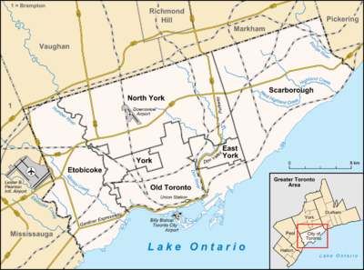 Location within Toronto | |
| Coordinates: 43°39′27″N 79°29′33″W / 43.65750°N 79.49250°WCoordinates: 43°39′27″N 79°29′33″W / 43.65750°N 79.49250°W | |
| Country |
|
| Province |
|
| City |
|
| Community | York |
| Settled | 1816 |
| Changed Municipality | 1998 Toronto from York |
| Government | |
| • MP | Arif Virani (Parkdale—High Park) |
| • MPP | Cheri DiNovo (Parkdale—High Park) |
| • Councillor | Sarah Doucette (Ward 13 Parkdale—High Park) |

Baby Point is a wealthy residential neighbourhood in the York district of Toronto, Ontario, Canada. It was part of the former City of York before the amalgamation of Toronto in 1998. The area began as two independent municipalities. It is bounded on the west by the Humber River from south of Baby Point Crescent to St. Marks Road, east to Jane Street and Jane Street south to Raymond Avenue and Raymond Avenue west to the Humber. It is within the city-defined neighbourhood of 'Lambton-Baby Point.' More recently, in 2010, local merchants formed the Baby Point Gates Business Improvement Area (a board under the City of Toronto) which runs along Jane St from Montye Ave in the north, to Lessard Ave in the south, and along Annette St from Jane St in the west, to Windermere Ave in the east.
In the 17th century, it was the site of the Iroquois village Teiaiagon, occupied by the Seneca and Mohawk, before the Marquis de Denonville led its destruction.
History

- Baby Point enclave
The Baby Point enclave was originally a Seneca village. James Baby, pronounced 'Bawby', was a member of a prominent Quebec fur trading family and a former politician in Upper Canada. He settled at Baby Point in 1816, after discovering the abandoned village. A lush apple orchard covered the area and salmon swam in the Humber River, giving it an Eden-like quality. Water from a fresh spring nearby was bottled and shipped worldwide.
Baby's heirs lived at Baby Point until 1910, when the government acquired the land with the intention of establishing a military fortress and barracks at the site. The government eventually changed their plans and sold the land to a developer named Home Smith, who began developing a subdivision in 1912. Home Smith would later develop a residential area across the Humber, The Kingsway.
Character
A set of historic stone gates at the intersection of Jane Street and Baby Point Road mark the entrance to the Baby Point enclave, which could be said to be a precursor to modern gated communities. Baby Point is situated on a peninsula of land—or a 'point' -- overlooking the Humber River. It is surrounded by ravines and parkland. The larger homes tend to back onto the Humber Valley ravine and are found along Baby Point Road and Baby Point Crescent, while the smaller homes are found near the Jane Street and Baby Point Road entrance. Most of the homes in the enclave were built in the 1920s and 1930s.
Demographics
In the 2006 census the Baby Point census tract had a population of 4,010 in 1,620 households. Less than one in ten of the population were visible minorities, the largest group being Chinese-Canadians with 90 individuals. Median earnings were at $43,581 per year, well above the Toronto average of $30,350.[1]
Schools
Humbercrest Public School is a Public Elementary school located on St. Mark's Road. Humbercrest is part of the Toronto District School Board, part of the SW1 Region in Ward 7. It was established in 1915 and provides instruction in both English and French from Junior Kindergarten to Grade 8. The French Immersion program begins in Senior Kindergarten.
Notable residents
- Conn Smythe - owner and manager of the Toronto Maple Leafs, and his family, were long-time residents of Baby Point Road.[2]
- Raymond Souster - Canadian poet (often described as Toronto’s unofficial poet laureate[3]), lived for many years on Baby Point Road.[4]
See also
- List of neighbourhoods in Toronto
- Schools in the TDSB
References
- Smythe, Conn; Young, Scott (1981). Conn Smythe: If you can't beat 'em in the alley. Toronto, Ontario: McClelland and Stewart. ISBN 0-7710-9078-1.
External links
- Baby Point Gates Business Improvement Area
- Lambton Baby Point neighbourhood profile
- Lambton Woods Park
- Humbercrest Public School
 |
Lambton, Rockcliffe-Smythe | | ||
| The Kingsway (Etobicoke) | |
Runnymede | ||
| ||||
| | ||||
| Old Mill | Swansea (Toronto) |