509 Harbourfront
| 509 Harbourfront | ||||||||||||||||||||||||||||||||||||||||||||||||||||||||||||||||||||||||||||||||||||||||||||||||||||||||||||||||||||||||||||||
|---|---|---|---|---|---|---|---|---|---|---|---|---|---|---|---|---|---|---|---|---|---|---|---|---|---|---|---|---|---|---|---|---|---|---|---|---|---|---|---|---|---|---|---|---|---|---|---|---|---|---|---|---|---|---|---|---|---|---|---|---|---|---|---|---|---|---|---|---|---|---|---|---|---|---|---|---|---|---|---|---|---|---|---|---|---|---|---|---|---|---|---|---|---|---|---|---|---|---|---|---|---|---|---|---|---|---|---|---|---|---|---|---|---|---|---|---|---|---|---|---|---|---|---|---|---|---|
|
| ||||||||||||||||||||||||||||||||||||||||||||||||||||||||||||||||||||||||||||||||||||||||||||||||||||||||||||||||||||||||||||||
| Overview | ||||||||||||||||||||||||||||||||||||||||||||||||||||||||||||||||||||||||||||||||||||||||||||||||||||||||||||||||||||||||||||||
| Type | Streetcar Route | |||||||||||||||||||||||||||||||||||||||||||||||||||||||||||||||||||||||||||||||||||||||||||||||||||||||||||||||||||||||||||||
| Locale | Toronto, Ontario | |||||||||||||||||||||||||||||||||||||||||||||||||||||||||||||||||||||||||||||||||||||||||||||||||||||||||||||||||||||||||||||
| Termini |
Union Station (East) Exhibition Loop (West) | |||||||||||||||||||||||||||||||||||||||||||||||||||||||||||||||||||||||||||||||||||||||||||||||||||||||||||||||||||||||||||||
| Stations |
| |||||||||||||||||||||||||||||||||||||||||||||||||||||||||||||||||||||||||||||||||||||||||||||||||||||||||||||||||||||||||||||
| Operation | ||||||||||||||||||||||||||||||||||||||||||||||||||||||||||||||||||||||||||||||||||||||||||||||||||||||||||||||||||||||||||||||
| Operator(s) | Toronto Transit Commission | |||||||||||||||||||||||||||||||||||||||||||||||||||||||||||||||||||||||||||||||||||||||||||||||||||||||||||||||||||||||||||||
| Depot(s) | Leslie Barns, Russell [1] | |||||||||||||||||||||||||||||||||||||||||||||||||||||||||||||||||||||||||||||||||||||||||||||||||||||||||||||||||||||||||||||
| Rolling stock | CLRV, Flexity Outlook | |||||||||||||||||||||||||||||||||||||||||||||||||||||||||||||||||||||||||||||||||||||||||||||||||||||||||||||||||||||||||||||
| Technical | ||||||||||||||||||||||||||||||||||||||||||||||||||||||||||||||||||||||||||||||||||||||||||||||||||||||||||||||||||||||||||||||
| Line length | 4.65 km (2.89 mi) [1] | |||||||||||||||||||||||||||||||||||||||||||||||||||||||||||||||||||||||||||||||||||||||||||||||||||||||||||||||||||||||||||||
| Track gauge | 4 ft 10 7⁄8 in (1,495 mm) - TTC Gauge | |||||||||||||||||||||||||||||||||||||||||||||||||||||||||||||||||||||||||||||||||||||||||||||||||||||||||||||||||||||||||||||
| Electrification | 600 VDC Overhead | |||||||||||||||||||||||||||||||||||||||||||||||||||||||||||||||||||||||||||||||||||||||||||||||||||||||||||||||||||||||||||||
| Route number | 509 | |||||||||||||||||||||||||||||||||||||||||||||||||||||||||||||||||||||||||||||||||||||||||||||||||||||||||||||||||||||||||||||
| ||||||||||||||||||||||||||||||||||||||||||||||||||||||||||||||||||||||||||||||||||||||||||||||||||||||||||||||||||||||||||||||

509 Harbourfront is a streetcar route in Toronto,[2] Ontario, Canada, operated by the Toronto Transit Commission.
History
The Harbourfront LRT began service in 1990 as the 604 Harbourfront. It was the first new Toronto streetcar route in many years, and the first to employ a dedicated tunnel, approximately 600 metres long. This starts with an underground loop at Union Station, runs south along Bay Street to the underground Queens Quay station, then turns west and emerges onto Queens Quay. The line's original terminus was Queens Quay and Spadina Loop, at the foot of Spadina Avenue; beyond this point non-revenue trackage ran north on Spadina to King, as otherwise the new line would have been disconnected from the rest of the network.
Numbers in the 600-series were used at that time within the TTC for rapid transit routes (i.e., subways and the Scarborough RT) rather than low numbers as is the case today, and the Harbourfront LRT was given a number in this series to indicate that it was different from other streetcar routes; it was also shown like a subway line on the TTC map. Since the route is not grade-separated, this was later felt to be misleading and it was treated like other streetcar lines, taking the number 510.
In 1997, the completion of a dedicated right-of-way on Spadina Avenue resulted in the Harbourfront route being relaunched as the 510 Spadina. The "Harbourfront" route name disappeared until 2000, when the Queens Quay streetcar tracks were extended west to Bathurst and Fleet Streets. The Harbourfront was then reinstated with the new number 509, and extended to Exhibition Loop at Exhibition Place, sharing its route with the 510 from Union to Spadina and with the 511 Bathurst from Bathurst onwards. The Fleet Street portion of Route 509 has since been converted to a parallel private right-of-way, so that the entire route operates entirely separate from road traffic.
A proposed Waterfront West project would have extended the Harbourfront line farther west to join the existing right-of-way along the Queensway, however this project was shelved by the city in 2013.[3]

In July 2012 Waterfront Toronto began a major reconstruction of Queen's Quay West, requiring the 509 streetcar to be replaced with buses for the duration of the construction.[4] On October 12, 2014, streetcar service resumed on 509 Harbourfront route after an absence of over two years in order to rebuild the street to a new design, and to replace tracks. With the new street design, two auto lanes south of the streetcar tracks were eliminated from Spadina Avenue to York Street in order to extend Harbourfront parkland to the edge of the streetcar right-of-way. Thus, streetcars now effectively run on a roadside right-of-way instead of a mid-street median. A bicycle path and rows of trees are located on the immediate south side of the right-of-way.[5]
By August 2016, the TTC reported that streetcars were taking 40 minutes to make a round trip instead of an expected 34 minutes. The new side-of-road track design results in streetcars encountering more traffic lights, pedestrians and cyclists, the latter two requiring streetcar to operate slowly to avoid collisions. TTC service planner Scott Haskill suggested that “public realm and urban design” drove the Queens Quay redevelopment at the expense of transit planning. However, accidents along Queens Quay are no more frequent than along other streets.[6] Transit advocate Steve Munro analyzed the route's performance for May 2016 and concluded that the extra running time was consumed from Queens Quay Loop to the intersection of Bathurst and Fleet streets, and that the running time east of Spadina Avenue was the same as before the reconstruction because of fixes to traffic signal problems.[7]
Operation
Despite its political image as a 'modern, rapid transit' streetcar line, the 604 Harbourfront route began operating using rebuilt PCC streetcars, which were referred to as "Red Rockets" in a branding effort. These were soon replaced by Toronto's CLRV streetcars, which form the majority of the city's current fleet. Because of the amount of shared track, the Toronto Transit Commission has grouped the 509 Harbourfront and 510 Spadina routes together for accounting and measurement purposes.
The 509 Harbourfront streetcar line is operated primarily using standard CLRV streetcars, although since March 29, 2015, the line had been shared with the new Flexity Outlook low-floor vehicles. Since then, all 509 streetcars have operated using a proof-of-payment (POP) all-door boarding system.[8]
Route
Most stops along the 509 route are surface stops with islands separating the regular traffic from the streetcar tracks. Streetcars begin underground at Union Station and pass through a dedicated underground streetcar station at Queens Quay before climbing to the surface.[2]
Points of interest
| Location | Stops |
|---|---|
| Harbourfront Centre & Islands ferry docks | Queens Quay Station |
| Queen's Quay Terminal | Queens Quay Station, York Street |
| CN Tower | Lower Simcoe Street |
| Rogers Centre & Toronto Waterfront WaveDecks | Simcoe Street – Spadina Avenue |
| HTO Park | Rees Street |
| Billy Bishop Toronto City Airport | on the Islands, a block south of Bathurst Street & Queen's Quay |
| Old Fort York | Bathurst & Fleet Streets, Fort York Boulevard |
| HMCS York | Bastion |
| Fort York Armoury | Fort York Boulevard |
| Exhibition Place & Canadian National Exhibition | Strachan Avenue, Exhibition Loop |
| Ricoh Coliseum & Exhibition GO Station & BMO Field | Exhibition Loop |
References
- 1 2 http://www3.ttc.ca/PDF/Transit_Planning/Service_Summary_2009_10_18.pdf
- 1 2 "509 Harbourfront". Streetcar Routes. Toronto Transit Commission. Retrieved 3 November 2015.
- ↑ "Residents share wishlist for Toronto budget". InsideToronto.com. Retrieved 14 March 2014.
- ↑ "Buses to replace TTC's 509 Harbourfront streetcar during Queens Quay revitalization". TTC. Retrieved 14 March 2014.
- ↑ Steve Munro (2014-10-12). "Streetcars Return to Queens Quay". Steve Munro. Retrieved 2014-10-12.
- ↑ Ben Spurr (9 August 2016). "Queens Quay redesign proves popular though 'friction' remains". Toronto Star. Retrieved 2016-08-10.
- ↑ Steve Munro (19 July 2016). "Travel Times on Queens Quay West". Retrieved 2016-08-10.
- ↑ "Proof-of-Payment (POP)". Fares & Passes. Toronto Transit Commission. Retrieved 30 March 2015.
External links
![]() Media related to 509 Harbourfront at Wikimedia Commons
Media related to 509 Harbourfront at Wikimedia Commons
- Route 509 - Harbourfront Streetcar (Transit Toronto)
| Bus | 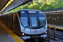 _(14918534190).jpg) | |
|---|---|---|
| Subway | ||
| Streetcars | ||
| History | ||
| Predecessors |
| |
| Facilities | ||
| Proposed | ||
| Miscellaneous | ||
Italics indicate a project under construction | ||