Yuruaní-tepui
| Yuruaní-tepui | |
|---|---|
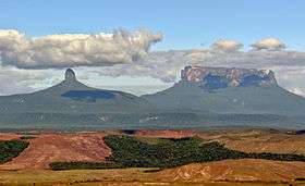 Yuruaní-tepui (right) and Wadakapiapué-tepui | |
| Highest point | |
| Elevation | 2,400 m (7,900 ft) [1] |
| Coordinates | 05°18′41″N 60°51′47″W / 5.31139°N 60.86306°WCoordinates: 05°18′41″N 60°51′47″W / 5.31139°N 60.86306°W |
| Geography | |
 Yuruaní-tepui Location in Venezuela | |
| Location | Cuyuni-Mazaruni, Guyana / Bolívar, Venezuela |
Yuruaní-tepui, also known by the Pemón name Iwalkarima, Iwalecalima[2] or Iwarkárima,[3] is a tepui of the Eastern Tepuis chain primarily situated in Venezuela, while part of the eastern ridge stretches into the disputed Guayana Esequiba territory in Guyana.[1] It has an elevation of around 2,400 metres (7,900 ft), the high plateau being located entirely within Venezuela, and a summit area of 4.38 km2 (1.69 sq mi). It lies just east of the much smaller Wadakapiapué-tepui.[1] This Tepui is not located in the Canaima National Park unlike most other Tepuis in the area.[4]
See also
References
- 1 2 3 Huber, O. (1995). Geographical and physical features. In: P.E. Berry, B.K. Holst & K. Yatskievych (eds.) Flora of the Venezuelan Guayana. Volume 1. Introduction. Missouri Botanical Garden Press, St. Louis. pp. 1–61.
- ↑ (Spanish) Brewer-Carías, C. (2012). "Roraima: madre de todos los ríos." (PDF). Río Verde 8: 77–94.
- ↑ (Spanish) El Tepuy - Características de los Tepuyes Archived January 20, 2013, at the Wayback Machine.. ExplorandoRutas.com.
- ↑ http://viajespereira.com.ve/wp-content/uploads/2015/11/mapa.jpg
Further reading
- Jaffe, K., J. Lattke & R. Perez-Hernández (January–June 1993). Ants on the tepuies of the Guiana Shield: a zoogeographic study. Ecotropicos 6(1): 21–28.
- Kok, P.J.R., R.D. MacCulloch, D.B. Means, K. Roelants, I. Van Bocxlaer & F. Bossuyt (7 August 2012). "Low genetic diversity in tepui summit vertebrates." (PDF). Current Biology 22(15): R589–R590. doi:10.1016/j.cub.2012.06.034 ["supplementary information" (PDF).]
- Rodder, D. & K.-H. Jungfer (2 July 2008). A new Pristimantis (Anura, Strabomantidae) from Yuruani-tepui, Venezuela. Zootaxa 1814: 58–68. ["first page" (PDF).]
This article is issued from Wikipedia - version of the 11/18/2016. The text is available under the Creative Commons Attribution/Share Alike but additional terms may apply for the media files.