Sororopán-tepui
| Sororopán-tepui | |
|---|---|
 Sororopán-tepui Location in Venezuela | |
| Highest point | |
| Elevation | 2,050 m (6,730 ft) [1] |
| Coordinates | 05°41′40″N 61°45′37″W / 5.69444°N 61.76028°WCoordinates: 05°41′40″N 61°45′37″W / 5.69444°N 61.76028°W |
| Geography | |
| Location | Bolívar, Venezuela |
Sororopán-tepui is a 10-kilometre (6.2 mi) long ridge in Bolívar state, Venezuela.[1] It has a maximum elevation of around 2,050 m (6,730 ft) and its densely forested slopes cover an estimated area of 30 km2 (12 sq mi). The ridge has a southwest–northeast orientation and is characterised by a steep southern face. Part of the Ptari Massif, it lies just south of Carrao-tepui and neighbouring Ptari-tepui.[1]
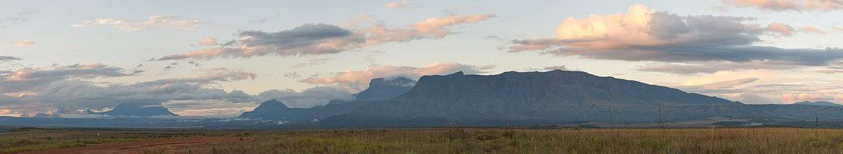
View from Kavanayén in the Gran Sabana, looking northwards. The large forested ridge is Sororopán-tepui, with Ptari-tepui visible just behind. Moving left is Moná-tepui and then, off in the distance, the Los Testigos chain, beginning with Kamarkawarai-tepui.
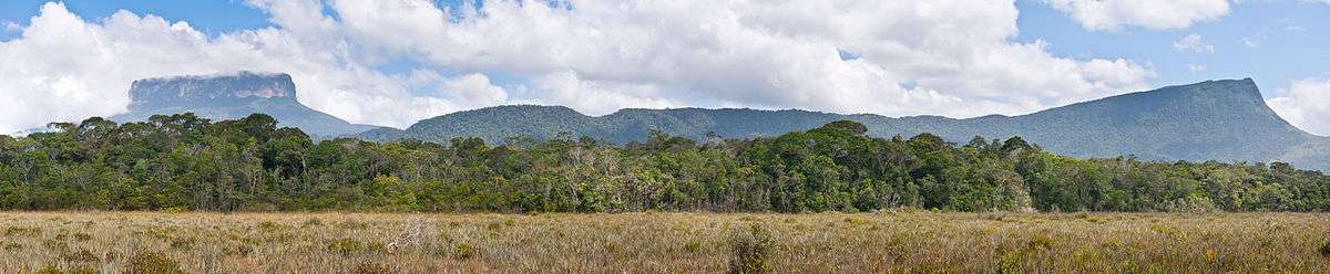
The flat, symmetrical peak of Ptari-tepui is visible on the left, with the long southwestern face of Sororopán-tepui extending to the right.
See also
References
- 1 2 3 Huber, O. (1995). Geographical and physical features. In: P.E. Berry, B.K. Holst & K. Yatskievych (eds.) Flora of the Venezuelan Guayana. Volume 1. Introduction. Missouri Botanical Garden Press, St. Louis. pp. 1–61.
Further reading
- Morton, C.V. (1957). Pteridophyta: Ptari-tepuí. [pp. 729–741] In: J.A. Steyermark et al. Botanical exploration in Venezuela -- 4. Fieldiana: Botany 28(4): 679–1225.
- Vegas-Vilarrúbia, T., S. Nogué & V. Rull (August 2012). Global warming, habitat shifts and potential refugia for biodiversity conservation in the neotropical Guayana Highlands. Biological Conservation 152: 159–168. doi:10.1016/j.biocon.2012.03.036
This article is issued from Wikipedia - version of the 12/25/2015. The text is available under the Creative Commons Attribution/Share Alike but additional terms may apply for the media files.