Canaima National Park
| Canaima National Park | |
|---|---|
|
IUCN category II (national park) | |
|
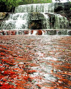
Jasper´s Creek (Canaima National Park) | |
 Location of Angel Falls in the Canaima National Park | |
| Location | Bolívar State, Venezuela |
| Coordinates | 6°10′0″N 62°30′0″W / 6.16667°N 62.50000°WCoordinates: 6°10′0″N 62°30′0″W / 6.16667°N 62.50000°W |
| Area | 30,000 km² |
| Established | June 12, 1962 |
| Type | Natural |
| Criteria | vii, viii, ix, x |
| Designated | 1994 (18th session) |
| Reference no. | 701 |
| State Party | Venezuela |
| Region | Latin America and the Caribbean |
Canaima National Park (Spanish: Parque Nacional Canaima) is a 30,000 km2 (12,000 sq mi) park in south-eastern Venezuela that roughly occupies the same area as the Gran Sabana region. It is located in Bolívar State, reaching the borders with Brazil and Guyana.
History
Canaima National Park was established on 12 June 1962.
As early as 1990 the countries that participate in the Amazonian Cooperation Treaty had recommended expanding the Canaima National Park southward to connect it with Monte Roraima National Park in Brazil, with coordinated management of tourism, research and conservation.[1] In 1994, the Canaima National Park was named a World Heritage Site by UNESCO, as a natural reserve that has abrupt relief special and unique around the world, the tepuis.
Location
Canaima National Park is the second largest park in Venezuela, after Parima-Tapirapecó, and sixth biggest national park in the world. It is the size of Belgium or Maryland.
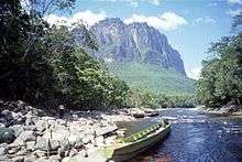
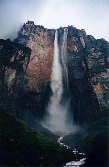
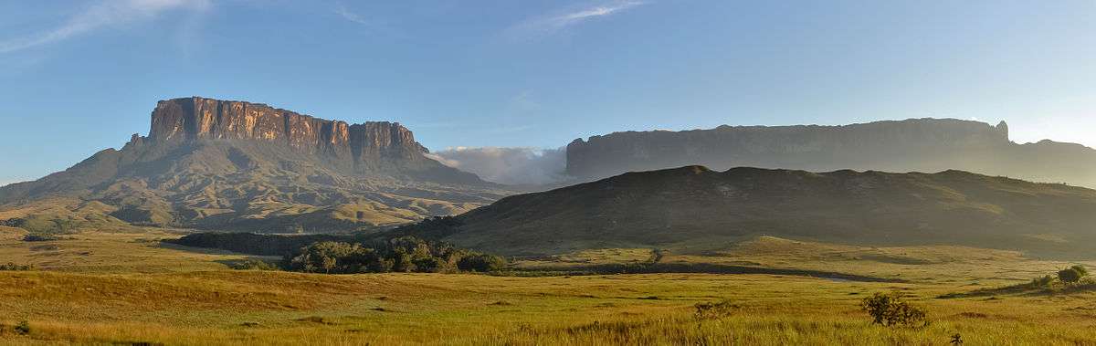
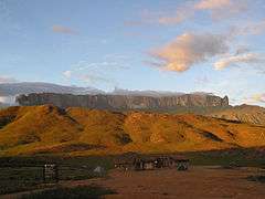
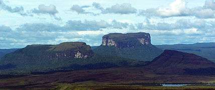
About 65% of the park is occupied by plateaus of rock called tepuis, which are a kind of table-top mountain millions of years old, with vertical walls and almost flat tops. These constitute a unique biological environment and are also of great geological interest. Their sheer cliffs and waterfalls (including Angel Falls, which is the highest waterfall in the world, at 1,002 metres (3,287 ft)) create spectacular landscapes. The most famous tepuis in the park are Mount Roraima, the tallest and easiest to climb, and Auyantepui, the site of Angel Falls. The tepuis are sandstone and date back to a time when South America and Africa were part of a super-continent.
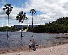
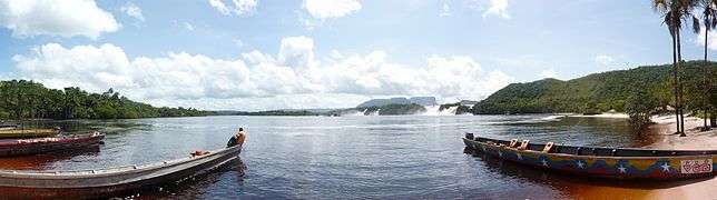
The park is home to indigenous Pemon Indians, part of the Carib linguistic group. The Pemon have an intimate relationship with the tepuis, and believe they are the home of the 'Mawari' spirits. The park is relatively remote, with only a few roads connecting towns. Most transport within the park is done by light plane from the airstrips built by various Capuchin missions, or by foot and canoe. Pemons have developed some basic and luxurious camps, which are mainly visited by tourists from across the world.
Fauna
Canaima has a varied fauna, which is distributed throughout the park according to multiple environmental factors such as altitude and vegetation type. Among the species found are:
- Giant armadillo (Priodontes maximus)
- Giant otter (Pteronura brasiliensis)
- Giant anteater (Myrmecophaga tridactyla)
- Cougar (Puma concolor)
- Jaguar (Panthera onca)
- Linnaeus's two-toed sloth (Choloepus didactylus)
- White-faced saki (Pithecia pithecia)
- Brown-backed bearded saki (Chiropotes israelita)
- Roraima mouse (Podoxymys roraimae)
- Tyleria mouse opossum (Marmosa tyleriana)
- Harpy eagle (Harpia harpyja)
- Red-shouldered macaw (Diopsittaca nobilis)
- Dusky parrot (Pionus fuscus)
- Yellow-banded poison dart frog (Dendrobates leucomelas)
- Green iguana (Iguana iguana)
- Hummingbirds (Trochilinae)
- Toucans (Ramphastidae).
- South American bushmaster (Lachesis muta)
Flora
There are over 300 species endemic only in La Gran Sabana.
- Endemic genera: Achnopogon, Chimantaea, Quelchia, Tepuia, Mallophyton, Adenanthe.
- Abundant insectivorous species from the genera: Bromelia, Drosera, Heliamphora, Utricularia.
Hydrography
The park includes the entire watershed of the right bank of the Caroní River, and two of the highest waterfalls in the world, the Angel Falls and the Kukenán and plenty of waterfalls of lower altitude.
Relief
The only form of relief are the tepuis, that are plateaus which are unique features, among which are its vertical and nearly flat tops, although there are several tepuies that do not meet these rules. Geologically are remnants of a sedimentary cover composed of very ancient sandstone that is superimposed on a base of igneous rocks (mainly granite) that is even older (nearly 3 billion years). On its summit is home to a very substantial amount of very specific endemic species, both plant and animal. Some endemic plant species are categorized as "carnivorous", which are thus the food supply (mainly insects) that are so scarce in the mountains. These have a geological formations ranging between 1.5 and 2 billion years, which makes them one of the oldest formations in the world. The best known tepuies are: the Auyantepuy (where it follows the Angel Falls), the Roraima, the Kukenan and the Chimantá among many others.
Tourist attractions
Western Sector
|
|
Eastern Sector
|
|
Canaima National Park is spread in south-eastern Venezuela along the border between Guyana and Brazil. The best-known feature of Canaima National Park are its characteristic flat-topped mountain formations known as 'tepuis' which cover roughly 65% of the park. The tepuis constitute a unique biogeological entity and are of great geological interest.
Gallery
 Canaima Lagoon panoramic
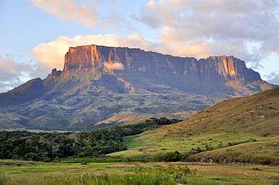 Kukenan Sunset
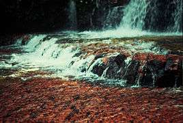
 Mount Roraima
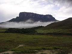 Kukenan Tepui
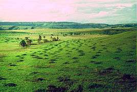
 Tepuies in Canaima
.jpg) Chinak-Meru
Chinak-Meru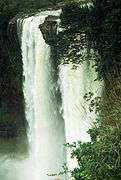 Kamá Falls
.jpg) Waterfalls of Canaima
Waterfalls of Canaima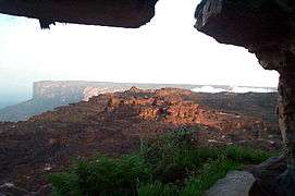 Kukenan Tepui
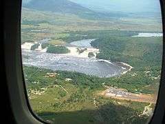 View from inbound plane of Canaima Lagoon, Saltos Golondrina, Saltos Ucaima and the airstrip
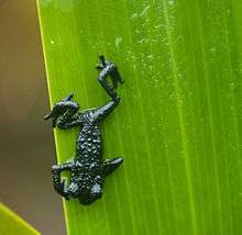 Roraima black frog - Oreophrynella quelchii
See also
References
- ↑ McNeely, Jeffrey A.; Harrison, Jeremy (1994), Protecting Nature: Regional Reviews of Protected Areas, IUCN, p. 377, ISBN 978-2-8317-0119-6, retrieved 2016-06-08
External links
| Wikimedia Commons has media related to Canaima National Park. |
| Wikivoyage has a travel guide for Canaima National Park. |
- Official information about the Canaima National Park
- UNEP World Conservation Monitoring Centre
- Official UNESCO website entry
- Video from Canaima National Park
- Canaima National Park
- Protected Planet Page for Canaima
| Western Venezuela |
| |
|---|---|---|
| Venezuelan Andes |
| |
| Los Llanos |
| |
| Central Region |
| |
| Eastern Region |
| |
| Region of Guayana |
| |
| Offshore |
| |