Wadakapiapué-tepui
| Wadakapiapué-tepui | |
|---|---|
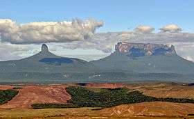 Wadakapiapué-tepui (left) and Yuruaní-tepui | |
| Highest point | |
| Elevation | 2,000 m (6,600 ft) [1] |
| Coordinates | 05°18′59″N 60°55′23″W / 5.31639°N 60.92306°WCoordinates: 05°18′59″N 60°55′23″W / 5.31639°N 60.92306°W |
| Geography | |
 Wadakapiapué-tepui Location in Venezuela | |
| Location | Bolívar, Venezuela |
Wadakapiapué-tepui, also spelled Wadakapiapö,[2] Wadakapiapo,[3] Wadaka Piapo or Guadacapiapui,[4] is a tepui of the Eastern Tepuis chain in Bolívar, Venezuela.[1] It has an elevation of around 2,000 metres (6,600 ft). Its tiny tower-like summit has an area of less than 0.01 km2 (0.0039 sq mi), making it the smallest member of the Eastern Tepuis. It lies just west of the much larger Yuruaní-tepui.[1]
See also
References
- 1 2 3 Huber, O. (1995). Geographical and physical features. In: P.E. Berry, B.K. Holst & K. Yatskievych (eds.) Flora of the Venezuelan Guayana. Volume 1. Introduction. Missouri Botanical Garden Press, St. Louis. pp. 1–61.
- ↑ (Spanish) El Tepuy - Características de los Tepuyes. ExplorandoRutas.com.
- ↑ (Spanish) Arnaldes, J. (June 2011). "La Gran Sabana II: Turismo a pie y de contacto..." (PDF). PrimeraClase.net.
- ↑ (Spanish) Brewer-Carías, C. (2012). "Roraima: madre de todos los ríos." (PDF). Río Verde 8: 77–94.
This article is issued from Wikipedia - version of the 11/18/2016. The text is available under the Creative Commons Attribution/Share Alike but additional terms may apply for the media files.