Dias Creek, New Jersey
| Dias Creek, New Jersey | |
|---|---|
| Unincorporated community | |
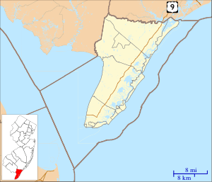 Dias Creek  Dias Creek  Dias Creek Location in Cape May County (Inset: Cape May County in New Jersey) | |
| Coordinates: 39°5′20″N 74°52′50″W / 39.08889°N 74.88056°WCoordinates: 39°5′20″N 74°52′50″W / 39.08889°N 74.88056°W | |
| Country |
|
| State |
|
| County | Cape May |
| Township | Middle |
| Elevation[1] | 13 ft (4 m) |
| Time zone | Eastern (EST) (UTC-5) |
| • Summer (DST) | EDT (UTC-4) |
| GNIS feature ID | 875911[1] |
Dias Creek (also known as Dyars Creek, Dyer's Creek or Dyers Creek[1]) is an unincorporated community located within Middle Township, in Cape May County, New Jersey, United States.[2] The community is traversed by Route 47, and primarily consists of farmland, woods, and campgrounds for vacationers.[3][4]
Wineries
References
- 1 2 3 Dias Creek, Geographic Names Information System. Accessed December 29, 2014.
- ↑ Locality Search, State of New Jersey. Accessed December 29, 2014.
- ↑ Lala, Elisa. "Cape May Tech students plant fruit trees on six-generations-old Dias Creek farm" in The Press of Atlantic City, April 24, 2013. Accessed June 8, 2013.
- ↑ Nark, Jason. "Philly teen drowns in Shore campground pool" in The Philadelphia Inquirer, June 10, 2011. Accessed June 8, 2013.
Municipalities and communities of Cape May County, New Jersey, United States | ||
|---|---|---|
| Cities | 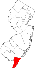 | |
| Boroughs | ||
| Townships | ||
| CDPs | ||
| Other unincorporated communities | ||
This article is issued from Wikipedia - version of the 6/8/2016. The text is available under the Creative Commons Attribution/Share Alike but additional terms may apply for the media files.