Stanhope, New Jersey
| Stanhope, New Jersey | |
|---|---|
| Borough | |
| Borough of Stanhope | |
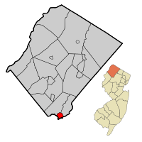 Map of Stanhope in Sussex County. Inset: Location of Sussex County highlighted in the State of New Jersey. | |
 Census Bureau map of Stanhope, New Jersey | |
| Coordinates: 40°54′47″N 74°42′10″W / 40.912976°N 74.702914°WCoordinates: 40°54′47″N 74°42′10″W / 40.912976°N 74.702914°W[1][2] | |
| Country |
|
| State |
|
| County | Sussex |
| Incorporated | March 24, 1904 |
| Government[3] | |
| • Type | Borough |
| • Body | Borough Council |
| • Mayor | Rosemary Maio (R, term ends December 31, 2019)[4][5] |
| • Administrator | Brian McNeilly[6] |
| • Clerk | Ellen Horak[7] |
| Area[1] | |
| • Total | 2.188 sq mi (5.667 km2) |
| • Land | 1.836 sq mi (4.755 km2) |
| • Water | 0.352 sq mi (0.912 km2) 16.10% |
| Area rank |
395th of 566 in state 20th of 24 in county[1] |
| Elevation[8] | 961 ft (293 m) |
| Population (2010 Census)[9][10][11] | |
| • Total | 3,610 |
| • Estimate (2015)[12] | 3,410 |
| • Rank |
427th of 566 in state 14th of 24 in county[13] |
| • Density | 1,966.3/sq mi (759.2/km2) |
| • Density rank |
293rd of 566 in state 4th of 24 in county[13] |
| Time zone | Eastern (EST) (UTC-5) |
| • Summer (DST) | Eastern (EDT) (UTC-4) |
| ZIP code | 07874[14][15] |
| Area code(s) | 973[16] |
| FIPS code | 3403770380[1][17][18] |
| GNIS feature ID | 0885408[1][19] |
| Website |
stanhopenj |
Stanhope is a borough in Sussex County, New Jersey, United States. As of the 2010 United States Census, the borough's population was 3,610,[9][10][11] reflecting an increase of 26 (+0.7%) from the 3,584 counted in the 2000 Census, which had in turn increased by 191 (+5.6%) from the 3,393 counted in the 1990 Census.[20]
Stanhope was formed by an act of the New Jersey Legislature on March 24, 1904, from portions of Byram Township.[21][22]
Geography
According to the United States Census Bureau, Stanhope borough had a total area of 2.188 square miles (5.667 km2), including 1.836 square miles (4.755 km2) of land and 0.352 square miles (0.912 km2) of water (16.1%).[1][2]
Unincorporated communities, localities and place names located partially or completely within the borough include Lake Musconetcong.[23]
Demographics
| Historical population | |||
|---|---|---|---|
| Census | Pop. | %± | |
| 1910 | 1,031 | — | |
| 1920 | 1,031 | 0.0% | |
| 1930 | 1,089 | 5.6% | |
| 1940 | 1,100 | 1.0% | |
| 1950 | 1,351 | 22.8% | |
| 1960 | 1,814 | 34.3% | |
| 1970 | 3,040 | 67.6% | |
| 1980 | 3,638 | 19.7% | |
| 1990 | 3,393 | −6.7% | |
| 2000 | 3,584 | 5.6% | |
| 2010 | 3,610 | 0.7% | |
| Est. 2015 | 3,410 | [12][24] | −5.5% |
| Population sources: 1910-1920[25] 1910[26] 1910-1930[27] 1930-1990[28] 2000[29][30] 2010[9][10][11] | |||
Census 2010
At the 2010 United States Census, there were 3,610 people, 1,396 households, and 957.7 families residing in the borough. The population density was 1,966.3 per square mile (759.2/km2). There were 1,472 housing units at an average density of 801.8 per square mile (309.6/km2). The racial makeup of the borough was 91.36% (3,298) White, 1.58% (57) Black or African American, 0.08% (3) Native American, 2.33% (84) Asian, 0.00% (0) Pacific Islander, 2.63% (95) from other races, and 2.02% (73) from two or more races. Hispanics or Latinos of any race were 8.50% (307) of the population.[9]
There were 1,396 households, of which 31.7% had children under the age of 18 living with them, 53.2% were married couples living together, 11.0% had a female householder with no husband present, and 31.4% were non-families. 25.1% of all households were made up of individuals, and 6.6% had someone living alone who was 65 years of age or older. The average household size was 2.58 and the average family size was 3.11.[9]
In the borough, 22.7% of the population were under the age of 18, 7.9% from 18 to 24, 28.2% from 25 to 44, 30.8% from 45 to 64, and 10.4% who were 65 years of age or older. The median age was 39.5 years. For every 100 females there were 93.2 males. For every 100 females age 18 and over, there were 91.4 males.[9]
The Census Bureau's 2006-2010 American Community Survey showed that (in 2010 inflation-adjusted dollars) median household income was $78,625 (with a margin of error of +/- $10,138) and the median family income was $94,545 (+/- $11,809). Males had a median income of $51,974 (+/- $7,042) versus $47,241 (+/- $3,337) for females. The per capita income for the borough was $35,934 (+/- $4,607). About 0.9% of families and 3.2% of the population were below the poverty line, including 3.6% of those under age 18 and 0.0% of those age 65 or over.[31]
Census 2000
As of the 2000 United States Census[17] there were 3,584 people, 1,384 households, and 978 families residing in the borough. The population density was 1,913.6 people per square mile (740.0/km2). There were 1,419 housing units at an average density of 757.7 per square mile (293.0/km2). The racial makeup of the borough was 93.55% White, 1.34% African American, 0.06% Native American, 1.53% Asian, 0.08% Pacific Islander, 1.40% from other races, and 2.04% from two or more races. Hispanic or Latino of any race were 4.05% of the population.[29][30]
There were 1,384 households out of which 34.3% had children under the age of 18 living with them, 58.3% were married couples living together, 8.9% had a female householder with no husband present, and 29.3% were non-families. 22.9% of all households were made up of individuals and 4.2% had someone living alone who was 65 years of age or older. The average household size was 2.58 and the average family size was 3.10.[29][30]
In the borough the population was spread out with 25.1% under the age of 18, 5.9% from 18 to 24, 34.7% from 25 to 44, 26.8% from 45 to 64, and 7.5% who were 65 years of age or older. The median age was 37 years. For every 100 females there were 90.2 males. For every 100 females age 18 and over, there were 90.0 males.[29][30]
The median income for a household in the borough was $63,059, and the median income for a family was $73,203. Males had a median income of $49,861 versus $36,545 for females. The per capita income for the borough was $27,535. About 1.7% of families and 2.2% of the population were below the poverty line, including 0.7% of those under age 18 and 2.4% of those age 65 or over.[29][30]
Government
Local government
Stanhope is governed under the Borough form of New Jersey municipal government. The governing body consists of a Mayor and a Borough Council comprising six council members, with all positions elected at-large on a partisan basis as part of the November general election. A Mayor is elected directly by the voters to a four-year term of office. The Borough Council consists of six members elected to serve three-year terms on a staggered basis, with two seats coming up for election each year in a three-year cycle.[3] The Borough form of government used by Stanhope, the most common system used in the state, is a "weak mayor / strong council" government in which council members act as the legislative body with the mayor presiding at meetings and voting only in the event of a tie. The mayor can veto ordinances subject to an override by a two-thirds majority vote of the council. The mayor makes committee and liaison assignments for council members, and most appointments are made by the mayor with the advice and consent of the council.[32][33]
As of 2016, the Mayor of Stanhope Borough is Republican Rosemarie Maio, whose term of office ends December 31, 2019. Members of the Borough Council are Council President Bill Thornton (R, 2018), Michael A. Depew (D, 2017), Diana M. Kuncken (R, 2016), Thomas J. Romano (R, 2017), Doreen Thistleton (R, 2016) and Patricia Zdichocki (R, 2018).[4][34][35][36][37]
Federal, state and county representation
Stanhope is located in the 11th Congressional District[38] and is part of New Jersey's 24th state legislative district.[10][39][40]
New Jersey's Eleventh Congressional District is represented by Rodney Frelinghuysen (R, Harding Township).[41] New Jersey is represented in the United States Senate by Cory Booker (D, Newark, term ends 2021)[42] and Bob Menendez (D, Paramus, 2019).[43][44]
For the 2016–2017 session (Senate, General Assembly), the 24th Legislative District of the New Jersey Legislature is represented in the State Senate by Steve Oroho (R, Franklin) and in the General Assembly by Parker Space (R, Wantage Township) and Gail Phoebus (R, Andover Township).[45] The Governor of New Jersey is Chris Christie (R, Mendham Township).[46] The Lieutenant Governor of New Jersey is Kim Guadagno (R, Monmouth Beach).[47]
Sussex County is governed by a Board of Chosen Freeholders whose five members are elected at-large in partisan elections on a staggered basis, with either one or two seats coming up for election each year. At an annual reorganization meeting held in the beginning of January, the board selects a Freeholder Director and Deputy Director from among its members, with day-to-day supervision of the operation of the county delegated to a County Administrator.[48] As of 2014, Sussex County's Freeholders are Freeholder Director Richard Vohden (R, Green Township, 2016),[49] Deputy Director Dennis J. Mudrick (R, Sparta Township, 2015),[50] Phillip R. Crabb (R, Franklin, 2014),[51] George Graham (R, Stanhope, 2016)[52] and Gail Phoebus (R, Andover Township, 2015).[53][48] Graham was chosen in April 2013 to fill the seat vacated by Parker Space, who had been chosen to fill a vacancy in the New Jersey General Assembly.[54] Constitutional officers elected on a countywide basis are County Clerk Jeff Parrott (R, 2016),[55] Sheriff Michael F. Strada (R, 2016)[56] and Surrogate Gary R. Chiusano (R, filling the vacancy after the resignation of Nancy Fitzgibbons).[57][54] The County Administrator is John Eskilson.[58][59]
Politics
As of March 23, 2011, there were a total of 2,403 registered voters in Stanhope, of which 486 (20.2% vs. 16.5% countywide) were registered as Democrats, 754 (31.4% vs. 39.3%) were registered as Republicans and 1,159 (48.2% vs. 44.1%) were registered as Unaffiliated. There were 4 voters registered to other parties.[60] Among the borough's 2010 Census population, 66.6% (vs. 65.8% in Sussex County) were registered to vote, including 86.1% of those ages 18 and over (vs. 86.5% countywide).[60][61]
In the 2012 presidential election, Republican Mitt Romney received 843 votes (52.2% vs. 59.4% countywide), ahead of Democrat Barack Obama with 738 votes (45.7% vs. 38.2%) and other candidates with 29 votes (1.8% vs. 2.1%), among the 1,614 ballots cast by the borough's 2,458 registered voters, for a turnout of 65.7% (vs. 68.3% in Sussex County).[62] In the 2008 presidential election, Republican John McCain received 995 votes (53.4% vs. 59.2% countywide), ahead of Democrat Barack Obama with 821 votes (44.1% vs. 38.7%) and other candidates with 30 votes (1.6% vs. 1.5%), among the 1,863 ballots cast by the borough's 2,384 registered voters, for a turnout of 78.1% (vs. 76.9% in Sussex County).[63] In the 2004 presidential election, Republican George W. Bush received 1,017 votes (59.4% vs. 63.9% countywide), ahead of Democrat John Kerry with 665 votes (38.8% vs. 34.4%) and other candidates with 25 votes (1.5% vs. 1.3%), among the 1,712 ballots cast by the borough's 2,200 registered voters, for a turnout of 77.8% (vs. 77.7% in the whole county).[64]
In the 2013 gubernatorial election, Republican Chris Christie received 69.8% of the vote (711 cast), ahead of Democrat Barbara Buono with 26.2% (267 votes), and other candidates with 3.9% (40 votes), among the 1,029 ballots cast by the borough's 2,475 registered voters (11 ballots were spoiled), for a turnout of 41.6%.[65][66] In the 2009 gubernatorial election, Republican Chris Christie received 716 votes (59.6% vs. 63.3% countywide), ahead of Democrat Jon Corzine with 354 votes (29.5% vs. 25.7%), Independent Chris Daggett with 105 votes (8.7% vs. 9.1%) and other candidates with 22 votes (1.8% vs. 1.3%), among the 1,201 ballots cast by the borough's 2,360 registered voters, yielding a 50.9% turnout (vs. 52.3% in the county).[67]
Education
The Stanhope Public Schools serve students in Kindergarten through eighth grade. As of the 2012-13 school year, the district's one school had an enrollment of 356 students and 28.0 classroom teachers (on an FTE basis), for a student–teacher ratio of 12.72:1.[68]
For ninth through twelfth grades, the borough shares Lenape Valley Regional High School, which serves public school students from Netcong in Morris County and the Sussex County communities of Byram Township and Stanhope.[69] As of the 2012-13 school year, the district's one school had an enrollment of 778 students and 63.3 classroom teachers (on an FTE basis), for a student–teacher ratio of 12.29:1.[70]
Transportation
Roads and highways
As of May 2010, the township had a total of 16.76 miles (26.97 km) of roadways, of which 12.75 miles (20.52 km) were maintained by the municipality, 2.24 miles (3.60 km) by Sussex County and 1.77 miles (2.85 km) by the New Jersey Department of Transportation.[71]
Route 183 is the main access road that serves the borough. U.S. Route 206 also passes through in the western section and is partially a limited access road (the "Netcong Bypass") which connects to Interstate 80 in neighboring Mount Olive.
Stanhope is noted for its highway oddity. Upon the completion of Interstate 80 (circa 1974), Old U.S. Route 206 through Stanhope was renamed Route 183. A section of Interstate 80 now acts as a traffic bypass around Stanhope.
Public transportation
Lakeland Bus Lines provides service operating along Interstate 80 between Newton, New Jersey and the Port Authority Bus Terminal in Midtown Manhattan.[72]
Points of interest
Waterloo Village, (located in Byram Township) in Allamuchy Mountain State Park, exhibits many different time periods from a 400-year-old Lenape (Delaware) Native American village to a bustling port along the once prosperous Morris Canal. The early 19th-century village contains a working mill with gristmills and sawmills, a general store, a blacksmith shop and restored houses. Classical and popular music programs are available to the public during the summer months.
Notable people
People who were born in, residents of, or otherwise closely associated with Stanhope include:
- Gamaliel Bartlett (1796–1859), first postmaster at Stanhope, appointed in 1823 by President James Monroe. In 1829, Bartlett petitioned the Sussex County Court for a license to "...keep an Inn or Tavern in the house in which he now lives, in the Township of Byram..." It was signed by the 16 town council members (referred to as Freeholders!). Probably the location of the proposed licensed premises was what is locally referred to as: The Stanhope House.[73]
- Rob Freeman (born 1981), former guitarist, backing vocalist and primary songwriter for the pop punk/post-hardcore group Hidden in Plain View.[74]
- Alicia Luciano (born 1983), beauty pageant competitor who held the title of Miss New Jersey 2002 and competed in the Miss America 2003 Pageant.[75]
- Joe Reo, lead singer for Hidden in Plain View.[76]
- Dave Yovanovits, (born 1981), guard for the Cleveland Browns.[77][78]
References
- 1 2 3 4 5 6 2010 Census Gazetteer Files: New Jersey County Subdivisions, United States Census Bureau. Accessed May 21, 2015.
- 1 2 US Gazetteer files: 2010, 2000, and 1990, United States Census Bureau. Accessed September 4, 2014.
- 1 2 2012 New Jersey Legislative District Data Book, Rutgers University Edward J. Bloustein School of Planning and Public Policy, March 2013, p. 110.
- 1 2 Mayor and Council, Stanhope Borough. Accessed August 2, 2016.
- ↑ 2016 New Jersey Mayors Directory, New Jersey Department of Community Affairs. Accessed June 14, 2016.
- ↑ Borough Administrator, Stanhope Borough. Accessed August 2, 2016.
- ↑ Borough Clerk, Stanhope Borough. Accessed August 2, 2016.
- ↑ U.S. Geological Survey Geographic Names Information System: Borough of Stanhope, Geographic Names Information System. Accessed March 14, 2013.
- 1 2 3 4 5 6 DP-1 - Profile of General Population and Housing Characteristics: 2010 for Stanhope borough, Sussex County, New Jersey, United States Census Bureau. Accessed September 16, 2012.
- 1 2 3 4 Municipalities Grouped by 2011-2020 Legislative Districts, New Jersey Department of State, p. 11. Accessed January 6, 2013.
- 1 2 3 Profile of General Demographic Characteristics: 2010 for Stanhope borough, New Jersey Department of Labor and Workforce Development. Accessed September 16, 2012.
- 1 2 PEPANNRES - Annual Estimates of the Resident Population: April 1, 2010 to July 1, 2015 - 2015 Population Estimates for New Jersey municipalities, United States Census Bureau. Accessed May 22, 2016.
- 1 2 GCT-PH1 Population, Housing Units, Area, and Density: 2010 - State -- County Subdivision from the 2010 Census Summary File 1 for New Jersey, United States Census Bureau. Accessed September 16, 2012.
- ↑ Look Up a ZIP Code for Stanhope, NJ, United States Postal Service. Accessed September 16, 2012.
- ↑ Zip Codes, State of New Jersey. Accessed August 30, 2013.
- ↑ Area Code Lookup - NPA NXX for Stanhope, NJ, Area-Codes.com. Accessed August 30, 2013.
- 1 2 American FactFinder, United States Census Bureau. Accessed September 4, 2014.
- ↑ A Cure for the Common Codes: New Jersey, Missouri Census Data Center. Accessed September 16, 2012.
- ↑ US Board on Geographic Names, United States Geological Survey. Accessed September 4, 2014.
- ↑ Table 7. Population for the Counties and Municipalities in New Jersey: 1990, 2000 and 2010, New Jersey Department of Labor and Workforce Development, February 2011. Accessed September 16, 2012.
- ↑ Snyder, John P. The Story of New Jersey's Civil Boundaries: 1606-1968, Bureau of Geology and Topography; Trenton, New Jersey; 1969. p. 232. Accessed April 1, 2012.
- ↑ Honeyman, Abraham Van Doren. Index-analysis of the Statutes of New Jersey, 1896-1909: Together with References to All Acts, and Parts of Acts, in the 'General Statutes' and Pamphlet Laws Expressly Repealed: and the Statutory Crimes of New Jersey During the Same Period, p. 263. New Jersey Law Journal Publishing Company, 1910. Accessed October 9, 2015.
- ↑ Locality Search, State of New Jersey. Accessed May 21, 2015.
- ↑ Census Estimates for New Jersey April 1, 2010 to July 1, 2015, United States Census Bureau. Accessed May 22, 2016.
- ↑ Compendium of censuses 1726-1905: together with the tabulated returns of 1905, New Jersey Department of State, 1906. Accessed August 30, 2013.
- ↑ Thirteenth Census of the United States, 1910: Population by Counties and Minor Civil Divisions, 1910, 1900, 1890, United States Census Bureau, p. 338. Accessed September 16, 2012.
- ↑ Fifteenth Census of the United States : 1930 - Population Volume I, United States Census Bureau, p. 719. Accessed September 16, 2012.
- ↑ Table 6. New Jersey Resident Population by Municipality: 1930 - 1990, New Jersey Department of Labor and Workforce Development. Accessed June 28, 2015.
- 1 2 3 4 5 Census 2000 Profiles of Demographic / Social / Economic / Housing Characteristics for Stanhope borough, New Jersey, United States Census Bureau. Accessed September 16, 2012.
- 1 2 3 4 5 DP-1: Profile of General Demographic Characteristics: 2000 - Census 2000 Summary File 1 (SF 1) 100-Percent Data for Stanhope borough, Sussex County, New Jersey, United States Census Bureau. Accessed September 16, 2012.
- ↑ DP03: Selected Economic Characteristics from the 2006-2010 American Community Survey 5-Year Estimates for Stanhope borough, Sussex County, New Jersey, United States Census Bureau. Accessed June 21, 2012.
- ↑ Cerra, Michael F. "Forms of Government: Everything You've Always Wanted to Know, But Were Afraid to Ask", New Jersey State League of Municipalities. Accessed November 30, 2014.
- ↑ "Forms of Municipal Government in New Jersey", p. 6. Rutgers University Center for Government Studies. Accessed June 3, 2015.
- ↑ 2016 Municipal User Friendly Budget, Stanhope Borough. Accessed August 2, 2016.
- ↑ Sussex County General Election November 3, 2015 Summary Report Official Results, Sussex County, New Jersey Clerk, updated November 6, 2015. Accessed August 1, 2016.
- ↑ Sussex County General Election November 4, 2014 Summary Report Official Results, Sussex County, New Jersey Clerk, updated November 10, 2014. Accessed August 1, 2016.
- ↑ Sussex County General and School Election November 5, 2013 Summary Report Official Results, Sussex County, New Jersey Clerk, updated November 7, 2013. Accessed August 1, 2016.
- ↑ Plan Components Report, New Jersey Redistricting Commission, December 23, 2011. Accessed January 6, 2013.
- ↑ 2016 New Jersey Citizen's Guide to Government, p. 64, New Jersey League of Women Voters. Accessed July 20, 2016.
- ↑ Districts by Number for 2011-2020, New Jersey Legislature. Accessed January 6, 2013.
- ↑ Directory of Representatives: New Jersey, United States House of Representatives. Accessed January 5, 2012.
- ↑ About Cory Booker, United States Senate. Accessed January 26, 2015. "He now owns a home and lives in Newark's Central Ward community."
- ↑ Biography of Bob Menendez, United States Senate, January 26, 2015. "He currently lives in Paramus and has two children, Alicia and Robert."
- ↑ Senators of the 114th Congress from New Jersey. United States Senate. Accessed January 26, 2015. "Booker, Cory A. - (D - NJ) Class II; Menendez, Robert - (D - NJ) Class I"
- ↑ Legislative Roster 2016-2017 Session, New Jersey Legislature. Accessed January 17, 2016.
- ↑ "About the Governor". State of New Jersey. Retrieved 2010-01-21.
- ↑ "About the Lieutenant Governor". State of New Jersey. Retrieved 2010-01-21.
- 1 2 Sussex County Board of Chosen Freeholders, Sussex County, New Jersey. Accessed July 28, 2014.
- ↑ Richard A. Vohden, Sussex County, New Jersey. Accessed July 28, 2014.
- ↑ Dennis J. Mudrick, Sussex County, New Jersey. Accessed July 28, 2014.
- ↑ Phillip R. Crabb, Sussex County, New Jersey. Accessed July 28, 2014.
- ↑ George Graham, Sussex County, New Jersey. Accessed July 28, 2014.
- ↑ Gail Phoebus, Sussex County, New Jersey. Accessed July 28, 2014.
- 1 2 Miller, Jennifer Jean. "George Graham Chosen as Freeholder at Sussex County Republican Convention", TheAlternativePress.com, April 13, 2013. Accessed April 25, 2013. "Graham will fill the freeholder seat that New Jersey Assemblyman Parker Space left to take his new position. Space recently took the seat, which formerly belonged to Gary Chiusano, who in turn, was appointed to the spot of Sussex County Surrogate, following the retirement of Surrogate Nancy Fitzgibbons."
- ↑ Home Page, Sussex County Clerk's Office. Accessed July 28, 2014.
- ↑ Sheriff's Office, Sussex County, New Jersey. Accessed July 28, 2014.
- ↑ Home Page, Sussex County Surrogate. Accessed July 28, 2014.
- ↑ County Administrator, Sussex County, New Jersey. Accessed July 28, 2014.
- ↑ Sussex County Official Directory 2014, Sussex County, New Jersey. Accessed July 28, 2014.
- 1 2 Voter Registration Summary - Sussex, New Jersey Department of State Division of Elections, March 23, 2011. Accessed February 25, 2013.
- ↑ GCT-P7: Selected Age Groups: 2010 - State -- County Subdivision; 2010 Census Summary File 1 for New Jersey, United States Census Bureau. Accessed February 25, 2013.
- ↑ General Election November 6, 2012: District Report - Group Detail, Sussex County, New Jersey Clerk, run date November 30, 2012. Accessed February 25, 2013.
- ↑ 2008 Presidential General Election Results: Sussex County, New Jersey Department of State Division of Elections, December 23, 2008. Accessed February 25, 2013.
- ↑ 2004 Presidential Election: Sussex County, New Jersey Department of State Division of Elections, December 13, 2004. Accessed February 25, 2013.
- ↑ "Governor - Sussex County" (PDF). New Jersey Department of Elections. January 29, 2014. Retrieved December 24, 2014.
- ↑ "Number of Registered Voters and Ballots Cast - November 5, 2013 - General Election Results - Sussex County" (PDF). New Jersey Department of Elections. January 29, 2014. Retrieved December 24, 2014.
- ↑ 2009 Governor: Sussex County, New Jersey Department of State Division of Elections, December 31, 2009. Accessed February 25, 2013.
- ↑ District information for Stanhope School District, National Center for Education Statistics. Accessed March 9, 2015.
- ↑ Lenape Valley Regional High School 2013 Report Card Narrative, New Jersey Department of Education. Accessed July 19, 2016. "Lenape Valley Regional High School is a comprehensive academic high school serving approximately 825 students in grade -12 from Byram Township and Stanhope Borough in Sussex County and from Netcong Borough in Morris County."
- ↑ District information for Lenape Valley Regional School District, National Center for Education Statistics. Accessed March 9, 2015.
- ↑ Sussex County Mileage by Municipality and Jurisdiction, New Jersey Department of Transportation, May 2010. Accessed July 18, 2014.
- ↑ Lakeland Rt 80 Newton to PABT, Lakeland Bus Lines. Accessed July 9, 2015.
- ↑ Staff. List of post-offices in the United States, with the names of the post-masters, of the counties and states, to which they belong:the distances from the city of Washington, and the seats of state governments, respectively; exhibiting the state of post-offices, on the 1st of June, 1828, p. 113, Way & Gideon, 1828. Accessed November 15, 2015.
- ↑ Hogan, Colin. "Hidden In Plain View: Interview With Rob Freeman", The Aquarian Weekly, March 16, 2005. Accessed October 9, 2015. "With a new release titled Life in Dreaming having hit stores on February 22nd sitting the band safely on the Billboard Charts at #154, it seems that Hidden in Plain View is anything but. It seems that the hometown heroes from Stanhope, New Jersey have definitely established a name for themselves. I was able to catch Rob Freeman, vocalist and guitarist of the band, to discuss the band, their album and upcoming tours."
- ↑ Miss New Jersey 2002, Miss America. Accessed October 9, 2015. "Name: Alicia Luciano; Hometown: Stanhope, New Jersey"
- ↑ Woliver, Robbie. "MUSIC; For Punk Band, Success Counts", The New York Times, April 1, 2011. Accessed October 9, 2015. "The band members -- Chris Amato, 23, bass player of Chatham; Joe Reo, 20, vocalist of Stanhope; Bob Freeman, 19, guitarist vocalist and songwriter of Stanhope; Kenny Ryan, 19, guitarist of Long Valley; Derek Reilly, 18, drummer of Rockaway -- have no qualms about acting in ways that their peers might view as selling out, as long as they get their music heard."
- ↑ Dave Yovanovits player profile, New York Jets. Accessed April 26, 2007. "Resides in Stanhope, NJ."
- ↑ Tatum, Kevin. "Owls pleasantly surprised by draft; The Patriots chose defensive lineman Dan Klecko, and the Jets took offensive tackle Dave Yovanovits.", The Philadelphia Inquirer, April 28, 2013. Accessed October 9, 2015. "At home in Stanhope, N.J., Dave Yovanovits was glued to the televised NFL draft coverage from New York."
External links
- Stanhope Borough website
- Sussex County webpage for Stanhope Borough
- Stanhope Police Department
- Stanhope Public Schools
- The Township Journal, community newspaper
- Stanhope Public Schools's 2014–15 School Report Card from the New Jersey Department of Education
- School Data for the Stanhope Public Schools, National Center for Education Statistics
- Lenape Valley Regional High School
Municipalities and communities of Sussex County, New Jersey, United States | ||
|---|---|---|
| Boroughs | 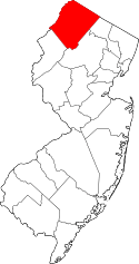 | |
| Town | ||
| Townships | ||
| CDPs | ||
| Other unincorporated communities | ||
 |
Byram Township | Hopatcong | | |
| |
||||
| ||||
| | ||||
| Mount Olive Township | Netcong | Roxbury Township |